Mori Atlas logo
National parkWallingat National Park

Discover the protected boundaries and regional geography of this Australian national park.

Wallingat National Park: Detailed Map Exploration of Protected Landscape in New South Wales

Wallingat National Park stands as a significant protected area within the diverse landscapes of New South Wales, Australia. This page serves as a detailed entry point for understanding the park's identity as a national park and its geographical context. Explore the mapped boundaries and the natural terrain that define this protected landscape, offering a unique perspective for atlas-driven discovery.

Australian national parksCoastal forestsNew South Wales protected areasWildlife observationBirdwatchingForest walking

Wallingat National Park

National park

Park overview

Structured park overview, official facts, and landscape profile for Wallingat National Park

Wallingat National Park park facts, protected area profile, and essential visitor context
Review the core facts for Wallingat National Park, including designation, size, terrain, visitor scale, habitats, and operating context in one park-focused overview.

About Wallingat National Park

Wallingat National Park occupies a stretch of coastal forest landscape in the Mid North Coast region of New South Wales, approximately a two-and-a-half-hour drive from Sydney. The park was formally established in 1999, adding to New South Wales's network of protected areas. Its proximity to the coast and position near Smiths Lake creates a distinctive setting where forest environments meet lake and coastal landscapes. The park is accessible via unsealed roads, which helps maintain its relatively wild character despite being within reach of a major population centre. Visitors can explore the forest through a network of walking tracks, camp along the banks of the Wallingat River, and ascend to the Whoota Whoota Lookout for elevated views over the surrounding terrain and Wallis Lake. The combination of forest ecosystem, river corridor, and coastal proximity makes this park a distinctive protected area in the regional context.

Quick facts and research context for Wallingat National Park

Wallingat National Park spans 65.57 square kilometres of coastal forest in northeastern New South Wales, situated between Smiths Lake and the Pacific coast. Established in 1999, the park features the Wallingat River running through its centre, with the Whoota Whoota Lookout providing sweeping views over Wallis Lake and the coastline. The terrain is predominantly forested with unsealed access roads, and the average elevation across the park is approximately 44 metres above sea level.

Park context

Deeper park guide and search-rich context for Wallingat National Park

Wallingat National Park history, landscape, wildlife, and travel context
Explore Wallingat National Park through its history, landscape character, ecosystems, wildlife, conservation priorities, cultural context, and seasonal travel timing in a structured park guide built for atlas discovery and search intent.

Why Wallingat National Park stands out

Wallingat National Park is best known for its accessible coastal forest environment and diverse wildlife populations. The park supports approximately 200 bird species alongside populations of wallabies and kangaroos, making it a notable destination for wildlife observation in the Sydney region. The Whoota Whoota Lookout offers one of the park's signature experiences, providing panoramic views across Wallis Lake to the coast. The riverside campsite along the Wallingat River provides a forested camping experience that is relatively uncommon so close to a major city.

Wallingat National Park history and protected-area timeline

Wallingat National Park was established in 1999 as part of the continued expansion of New South Wales's national park system. The creation of the park protected a significant area of coastal forestland that had previously existed in a less formal conservation status. The land was incorporated into the National Parks and Wildlife Service portfolio, which manages protected areas across New South Wales. The park's establishment reflected a recognition of the ecological value of the coastal forest environment in this region, including its biodiversity and watershed functions.

Wallingat National Park landscape and geographic character

The landscape of Wallingat National Park consists of gently rolling forested terrain with an average elevation of approximately 44 metres above sea level. The terrain is characteristic of coastal New South Wales, with native eucalyptus and other Australian forest species dominating the vegetation. The Wallingat River flows through the park, creating a riparian corridor and providing the focal point for the park's campsite. From the Whoota Whoota Lookout, visitors can observe Wallis Lake and gain perspectives across the coastal plain toward the Pacific Ocean. The overall topographic character is subdued compared to mountainous national parks, but the forest landscape and water views create a distinctive scenic quality.

Wallingat National Park ecosystems, habitats, and plant life

The park protects a coastal forest ecosystem typical of northeastern New South Wales. The vegetation consists primarily of dry sclerophyll forest, with eucalyptus species forming the dominant tree layer and a diverse understory of Australian native plants. The forest environment supports a range of habitats including the riparian zone along the Wallingat River, which provides more moist conditions and different plant communities than the surrounding slopes. The park's position between the coast and the Great Dividing Range influences the types of species present, with some species having distributions that extend from coastal areas into adjacent inland environments.

Wallingat National Park wildlife and species highlights

Wallingat National Park is notable for its wildlife populations, particularly birds. Approximately 200 bird species have been recorded in the park, reflecting the diversity of forest and edge habitats present in the area. Mammals including wallabies and kangaroos are present and can be observed, particularly in more open areas or during dawn and dusk when wildlife is most active. The combination of forest cover, water sources, and relatively intact habitat creates conditions that support both common Australian wildlife species and those with more specific habitat requirements. The park provides meaningful wildlife observation opportunities within a reasonably accessible distance from Sydney.

Wallingat National Park conservation status and protection priorities

The establishment of Wallingat National Park in 1999 provided formal protection to a coastal forest ecosystem in the Mid North Coast region of New South Wales. The protected status safeguards the forest habitats, riparian corridors, and the wildlife populations they support. As part of the national park category under IUCN classification II, the area is managed primarily for conservation while allowing for appropriate public recreation. The protection of the Wallingat River corridor and surrounding forest contributes to watershed health and provides a reference area for understanding coastal forest ecosystems in this part of New South Wales.

Wallingat National Park cultural meaning and human context

The park exists within the traditional lands of Aboriginal peoples, though the source material does not provide specific details about indigenous cultural associations with the area. The broader Mid North Coast region of New South Wales contains numerous sites of Aboriginal significance, and the landscape would have supported indigenous communities prior to European settlement. The place name Wallingat derives from the local area, though the specific etymology and traditional associations are not detailed in the available sources.

Top sights and standout views in Wallingat National Park

Wallingat National Park's highlights include the forest walking tracks that traverse the park's diverse terrain, the scenic riverside campsite along the Wallingat River, and the panoramic views available from the Whoota Whoota Lookout overlooking Wallis Lake and the coast. The wildlife viewing opportunities, particularly the birdlife and macropod populations, distinguish this park from other forested protected areas in the region. The combination of accessible nature-based recreation with relative proximity to Sydney makes the park a valuable escape for residents seeking coastal forest experiences without extensive travel.

Best time to visit Wallingat National Park

The park can be visited throughout the year, with different seasons offering varied experiences. Summer months bring warmer conditions suitable for riverside camping and swimming in the Wallingat River, though visitor numbers typically increase during this period. Autumn and spring offer moderate temperatures and often pleasant conditions for walking and wildlife observation. Winter brings cooler temperatures but still workable conditions for day visits and short walks. The unsealed roads may be affected by wet weather conditions, so visitors should check current conditions before traveling, particularly during the cooler months when rainfall is more likely in this region.
Park location guide

Geography guide, regional context, and park location map for Wallingat National Park

Wallingat National Park park geography, regions, and map view in Australia
Understand where Wallingat National Park sits in Australia through a broader geographic reading of the surrounding landscape, nearby location context, and its mapped position within the national park landscape.

How Wallingat National Park fits into Australia

Australia is a constitutional monarchy and federal parliamentary democracy comprising six states and ten territories. With a population of nearly 28 million, it is one of the world's most urbanised countries, with most people concentrated on the eastern seaboard. The country has a high Human Development Index and is known for its cultural diversity, ancient Aboriginal heritage, and unique wildlife.

Wider geography shaping Wallingat National Park in Australia

Australia occupies the entire Australian continent, the island of Tasmania, and numerous smaller islands. It is the world's flattest and driest inhabited continent, featuring vast deserts in the interior (the Outback), tropical rainforests along the eastern coast, and a coastline bordering the Indian and Pacific Oceans.

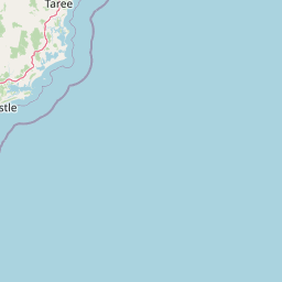
Map view of Wallingat National Park

Use this park location map to pinpoint Wallingat National Park in Australia, understand its exact geographic position, and read its mapped placement within the surrounding landscape more clearly.

Pigeon | © OpenStreetMap contributors

Location context for Wallingat National Park

New South Wales
Park atlas

Compare diverse protected landscapes and coastal forest zones across the surrounding New South Wales region

Discover Other National Parks and Protected Areas Near Wallingat National Park, New South Wales
After exploring Wallingat National Park, browse other national parks and protected areas within the coastal forests and regional geography of New South Wales. Expand your park discovery by comparing different protected landscapes, tracing their geographic spread, and understanding their conservation context in broader Australia.
National parkNew South Wales

Booti Booti National Park: New South Wales National Park Protected Landscape Atlas

Mapped boundaries and regional geography for this Australian national park.

Delve into the specifics of Booti Booti National Park, a designated national park within New South Wales, Australia. This resource facilitates a detailed understanding of its protected area status, landscape characteristics, and precise geographic placement. Explore its mapped features and regional context to enrich your atlas-based discovery of Australia's protected lands.

Area
15.67 km²
Established
1992
IUCN
II
Relief
Highland
National parkNew South Wales

Myall Lakes National Park National Park: Mapped Boundaries and Protected Landscape Exploration

Discover its regional geography and natural terrain context.

Delve into the specific protected landscape and geographic features of Myall Lakes National Park. As a national park located in New South Wales, it provides critical atlas context for understanding protected areas and their distribution. Explore its mapped terrain and boundaries to gain a deeper appreciation for this significant natural area within Australia's geography.

Area
448 km²
Established
1972
IUCN
II
Relief
Lowland
National parkNew South Wales

Tomaree National Park: New South Wales National Park with Defined Protected Boundaries

Explore its mapped geography and regional landscape context.

Tomaree National Park represents a significant protected landscape within New South Wales, Australia. This national park entry focuses on its distinct geographic features and mapped boundaries, offering a clear point of reference for atlas-based exploration. Understand its place in the regional geography of New South Wales and its identity as a conserved natural area. The detailed mapping and contextual data provide a solid foundation for appreciating this protected landscape.

Area
23.18 km²
Established
1984
IUCN
II
Relief
Lowland
National parkNew South Wales

Crowdy Bay National Park: New South Wales Protected Coastal Landscape and Terrain Map

Explore mapped boundaries and diverse natural geography within this national park.

Crowdy Bay National Park offers a compelling example of coastal protected landscape in New South Wales, Australia. This page facilitates a detailed atlas exploration of its natural geography, focusing on the interaction between ocean beaches, headlands, and inland forested terrain. Understand the park's specific location and its characteristic ecosystems, providing a structured view of this significant national park for geographic discovery.

Area
102 km²
Established
1972
IUCN
II
Relief
Lowland
National parkNew South Wales

Coorabakh National Park: A Protected Volcanic Landscape in New South Wales

Discover unique terrain, mapped protected boundaries, and regional geography.

Coorabakh National Park in New South Wales, Australia, is characterized by its striking volcanic trio: Big Nellie, Flat Nellie, and Little Nellie. These peaks dominate the rugged escarpment terrain, offering a unique geographic vista. The park protects a rich mosaic of tall eucalypt forests and sheltered subtropical rainforest gullies, highlighting its ecological diversity. For those interested in atlas-style exploration, Coorabakh National Park provides a clear example of a protected landscape with significant geological and ecological features within the broader regional context of New South Wales.

Area
18 km²
Established
1999
IUCN
II
Relief
Highland
National parkNew South Wales

Middle Brother National Park: New South Wales Protected Area and Geographic Exploration

Mapped boundaries and regional landscape context for this national park.

Middle Brother National Park represents a distinct protected landscape within the state of New South Wales, Australia. This entry offers detailed geographic context, focusing on the park's mapped boundaries and its significance as a national park. Users can explore its place within the regional geography of New South Wales, gaining a structured understanding of this protected area through an atlas-focused perspective.

Area
18.3 km²
Established
1999
IUCN
II
Relief
Mountain
National parkMid North Coast

Tapin Tops National Park: Protected Landscape in Mid North Coast, Australia

Mapped geographic context and natural terrain discovery.

Tapin Tops National Park is a designated national park offering rich opportunities for geographic and landscape exploration. This detail page provides a structured look at its protected area status and its location within the Mid North Coast region of Australia. Delve into the mapped boundaries and understand the park's specific natural terrain for comprehensive atlas-based discovery.

Area
110 km²
Established
1999
IUCN
II
Relief
Mountain
National parkNew South Wales

Dooragan National Park: Coastal Mountain Protected Landscape and Old-Growth Forest Atlas

Explore the geography and mapped boundaries of this New South Wales national park.

Dooragan National Park is a significant protected area in New South Wales, renowned for the dramatic North Brother Mountain and its exceptional old-growth blackbutt forests. This park offers a rich exploration of coastal mountain geography, providing valuable mapped landscape context for the Mid North Coast region. Discover the park's unique ecological environment and its role as a protected natural asset.

Area
11 km²
Established
1997
IUCN
II
Relief
Mountain

Common questions about visiting, size, designation, and location context for Wallingat National Park

Wallingat National Park FAQs for park facts, access, geography, and protected area context
Find quick answers about Wallingat National Park, including protected-area facts, park geography, trail and visitor context, and how the park fits into its surrounding country and regional landscape.
MoriAtlas Explorer

Continue Your Protected Areas Search Across the Global Atlas

Deepen your exploration by continuing the structured search for national parks and protected areas worldwide. Utilize the comprehensive filtering capabilities to compare different conservation landscapes and refine your understanding of global park geography. Discover more about the distribution and characteristics of protected natural areas.

Global natural geography