
Mori Atlas logo
Nature reserveWasservogelreservat Northeimer Seenplatte

A concentrated floodplain mosaic of gravel-pit lakes and waterbird habitats in Lower Saxony

Wasservogelreservat Northeimer Seenplatte Nature Reserve and Protected Wetland Landscape Geography

(Naturschutzgebiet Wasservogelreservat Northeimer Seenplatte)

Wasservogelreservat Northeimer Seenplatte stands as a significant nature reserve located within the Leine valley floodplain of Lower Saxony. This protected area features a series of gravel-pit lakes that have evolved into a vital mosaic of open-water and shoreline environments. The reserve serves as a critical node in regional bird conservation, providing habitat for migratory species and breeding waterfowl within a compact, human-framed terrain.

waterbird reservegravel-pit lakesfloodplainlower saxonybird sanctuarywetland
An illustrative depiction of a calm lake in the Northeimer Seenplatte, with lush green trees and shrubs in the foreground, a distant railway bridge over the water, and gentle rolling hills under a soft pastel sky.

Wasservogelreservat Northeimer Seenplatte

Nature reserve

Park overview

Structured park overview, official facts, and landscape profile for Wasservogelreservat Northeimer Seenplatte

Wasservogelreservat Northeimer Seenplatte park facts, protected area profile, and essential visitor context

Review the core facts for Wasservogelreservat Northeimer Seenplatte, including designation, size, terrain, visitor scale, habitats, and operating context in one park-focused overview.

About Wasservogelreservat Northeimer Seenplatte

The Wasservogelreservat Northeimer Seenplatte lies at the western edge of the larger Northeimer Seenplatte, a series of lakes in the Leine valley just north of the city of Northeim. From a landscape perspective, the reserve is a textbook example of how former mineral extraction sites can be transformed into ecologically valuable habitat. The lakes themselves were created through gravel mining (Kiesabbau), and although extraction has now largely ended in most of the pits, the resulting open water and shoreline environments have proven exceptionally attractive to waterbirds.

To the west and north of the lakes, the reserve includes areas that remain in agricultural use as grassland and arable fields, while the rest is shaped by its open water bodies, fringed vegetation, and the broader floodplain mosaic. The reserve sits within an unusually infrastructure-rich landscape: the A7 motorway bounds it to the south, the Hannover–Würzburg high-speed railway line and the north-south rail corridor pass along its eastern side, the embankment of Polder V of the Salzderhelden flood retention system lies to the northwest, and a regional road (L 572) defines part of the western boundary.

Despite this heavily engineered setting, the area functions as a refuge because it is nested within a chain of protected floodplain sites around Salzderhelden. It is fully contained within the EU Bird Directive Special Protection Area "Leinetal bei Salzderhelden" and adjoins the Leineniederung Salzderhelden nature reserve and Polder I of the Salzderhelden flood retention basin. Together, these sites form a coherent ecological network in the middle Leine valley that is managed in coordination between the Landkreis Northeim and the state-level NLWKN.

The reserve's profile is fundamentally shaped by its identity as a waterbird habitat. The combination of varying lake depths, shoreline structure, and nearby wet meadows produces ideal conditions for breeding, feeding, and staging waterbirds throughout much of the year. Observers can encounter species that would normally be associated with much larger lakes or coastal sites, making the area a notable birding destination within southern Lower Saxony. A themed walking trail laid out as the "Themenpfad Wasser" for Expo 2000 in Hannover runs through the reserve, and several observation points are set up for nature watching along the route.

Quick facts and research context for Wasservogelreservat Northeimer Seenplatte

The Wasservogelreservat Northeimer Seenplatte is a nature reserve in Lower Saxony, classified as an IUCN Category IV Habitat/Species Management Area and designated under the German Naturschutzgebiet framework with the identifier NSG BR 042. It lies in the Leine floodplain northwest of Northeim in the Landkreis Northeim, at roughly 107 to 111 meters above sea level, and covers about 80 hectares. The site is fully integrated into the EU Birds Directive Special Protection Area "Leinetal bei Salzderhelden" and is surrounded by infrastructure including the A7 motorway, the Hannover–Würzburg high-speed rail line, regional roads, and the Polder V flood retention embankment. Protection status dates to 2 March 1984, and the area has been recognized at the EU level as a special area for natural habitats since 1983.

Protection and recognition

Documented terrestrial protection metrics and official registry records

Wasservogelreservat Northeimer Seenplatte Protection Status and Mapped Territory

Wasservogelreservat Northeimer Seenplatte holds a documented terrestrial protection status within official registry records. Public conservation data outlines the registered geographic scope and baseline administrative metrics for this protected area.

Protection details

Protection scope
Terrestrial
Transboundary protection
No
WDPA ID
166185
Park context

Deeper park guide and search-rich context for Wasservogelreservat Northeimer Seenplatte

Wasservogelreservat Northeimer Seenplatte history, landscape, wildlife, and travel context

Explore Wasservogelreservat Northeimer Seenplatte through its history, landscape character, ecosystems, wildlife, conservation priorities, cultural context, and seasonal travel timing in a structured park guide built for atlas discovery and search intent.

Why Wasservogelreservat Northeimer Seenplatte stands out

The reserve is best known for its exceptional waterbird diversity in a compact floodplain setting. Over 170 bird species have been documented here, with the former gravel-pit lakes functioning as breeding grounds for great crested grebes, greylag and Egyptian geese, little ringed plovers, penduline tits, and kingfishers, as well as hosting a cormorant colony. The lakes are equally important for migratory and wintering birds, attracting terns and little gulls in passage, and a wide range of diving ducks, grebes, mergansers, and even sea ducks such as velvet and common scoters during the colder months.
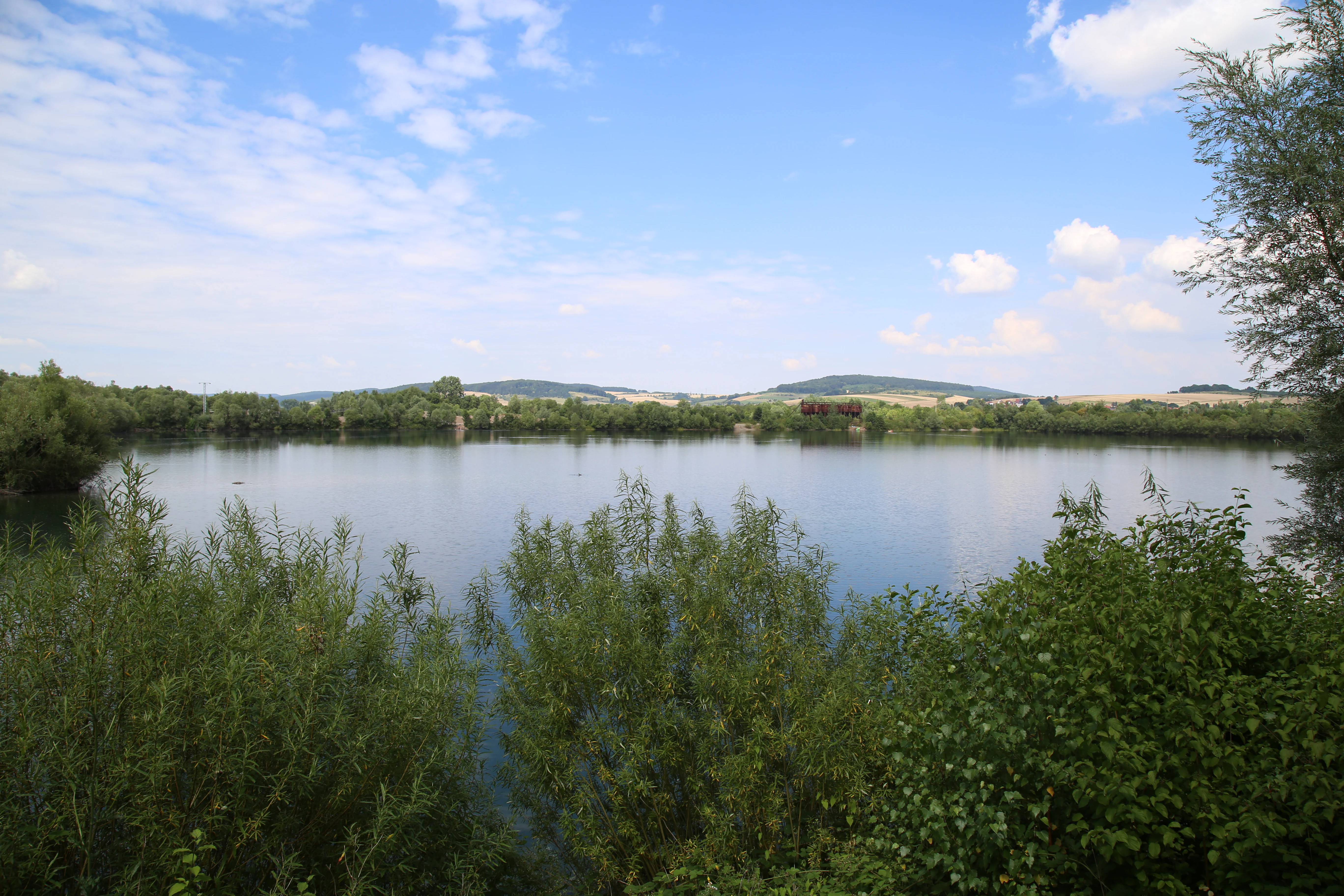
A wide view of a calm lake surrounded by lush green trees and shrubs under a blue sky with light clouds, with rolling hills visible in the background.
A view across a lake in the Northeim Lake District nature reserve.

Wasservogelreservat Northeimer Seenplatte history and protected-area timeline

The Wasservogelreservat Northeimer Seenplatte was formally designated as a Naturschutzgebiet on 2 March 1984, giving it the protected-area identifier NSG BR 042. It was, however, already recognized at the European level a year earlier, in 1983, when the EU listed it as a special area for the conservation of natural habitats (FFH-related recognition). This early European recognition reflects the fact that the lakes, formed through years of gravel extraction, had already developed into a habitat of considerable ecological interest by the early 1980s.

The reserve was established within a broader effort to protect the Leine floodplain near Salzderhelden, and it is fully integrated into the EU Bird Directive Special Protection Area "Leinetal bei Salzderhelden". It was also designed to function ecologically alongside neighboring floodplain protected sites, including the Leineniederung Salzderhelden reserve and Polder I of the Salzderhelden flood retention basin. Today, the area is administered by the Landkreis Northeim as the responsible lower nature conservation authority, with the Niedersächsischer Landesbetrieb für Wasserwirtschaft, Küsten- und Naturschutz (NLWKN) acting as the state-level coordinating body.

In 2000, the reserve gained an additional interpretive layer when a themed trail, the "Themenpfad Wasser" (Water Theme Path), was laid through the area as part of the Expo 2000 project in Hannover. The trail included observation points, embedding the site within a wider program of public environmental education along the Leine valley.

Wasservogelreservat Northeimer Seenplatte landscape and geographic character

The landscape of the Wasservogelreservat Northeimer Seenplatte is essentially a lowland floodplain mosaic of lakes, fringing vegetation, and agricultural fields. The central feature is a chain of Baggerseen, open-water lakes created through historic gravel mining in the Leineaue. Although these pits were originally industrial, their steep shorelines, variable depths, and disturbance-free character have made them ecologically attractive, and most extraction has since ceased across much of the reserve.

Surrounding the lakes, the western and northern parts of the reserve are still shaped by agricultural land use, with sections maintained as grassland and arable fields. This mixture gives the area a sharp contrast between open cultivated ground and the still, reflective surfaces of the lakes. The terrain lies at a relatively uniform low elevation between roughly 107 and 111 meters above sea level, characteristic of the flat Leine valley near Salzderhelden.

The reserve's boundary is defined almost entirely by major human-made features. The A7 motorway runs along its southern edge, the Hannover–Würzburg high-speed rail line and the associated north-south rail corridor lie to the east, a regional road (L 572) passes along the western side, and the embankment of Polder V of the Salzderhelden flood retention system defines part of the northwestern margin. Together, these features frame an unusually compact, self-contained wetland complex in the middle of an otherwise heavily used landscape.

Wasservogelreservat Northeimer Seenplatte ecosystems, habitats, and plant life

Ecologically, the Wasservogelreservat Northeimer Seenplatte is fundamentally a water-and-meadow complex. The lakes themselves are the ecological anchor, providing open-water, shoreline, and shallow-water habitats that support a wide range of water-dependent species. Around and between the lakes, fringing vegetation, wet meadows, and arable margins add structural diversity, while the wider grassland and farmland areas to the west and north contribute open-ground habitat.

The birdlife is the dominant ecological signal of the reserve. With over 170 recorded species, the lakes are widely used both as breeding habitat and as a staging site during migration. The mix of habitats, including open water, reed-fringed shoreline, grassland, and adjacent cultivation, allows the reserve to support species with very different ecological requirements within a very small area, and reinforces its role within the larger Leinetal bei Salzderhelden Special Protection Area.

The reserve functions as one of several complementary floodplain protected sites around Salzderhelden. Its integration with the Leineniederung Salzderhelden nature reserve and the Polder I site means that the ecological value of the Wasservogelreservat is amplified by the surrounding network of floodplain, meadow, and retention habitats. This network character is a defining aspect of the area's natural identity.

Wasservogelreservat Northeimer Seenplatte wildlife and species highlights

Wildlife interest in the Wasservogelreservat Northeimer Seenplatte centers overwhelmingly on birds. More than 170 species have been recorded, a striking figure for a reserve of about 80 hectares. Many species breed on site. The breeding community includes great crested grebes, greylag geese, Egyptian geese, little ringed plovers, penduline tits, and the strikingly colored kingfisher, along with a resident cormorant colony that uses the area as a breeding site.

During spring and autumn migration the reserve takes on a particularly dynamic character. Little gulls pass through, along with a suite of terns that includes common, Sandwich, black, and little terns. A wide variety of grebes also use the lakes during passage, including black-necked, red-necked, little, and horned grebes, and divers such as red-throated and black-throated (Pacific) divers may also appear. Sea ducks, normally associated with marine coasts, are occasional visitors in the form of common, velvet, and king eiders, scoters, and long-tailed ducks.

In winter, the reserve becomes a stronghold for waterfowl. Diving ducks such as common pochard and tufted duck overwinter on the lakes, joined by goldeneyes and a range of sawbills including goosander, smew, and red-breasted merganser. Coots and great crested grebes are regular winter presences, and the reserve also supports wintering bitterns, a notably secretive heron species. This combination of breeding, migrating, and wintering waterbirds in one small area gives the site an unusually rich and varied ornithological profile.

Wasservogelreservat Northeimer Seenplatte conservation status and protection priorities

The reserve's conservation significance lies in its role as a compact but exceptionally rich waterbird refuge embedded within the larger Leine floodplain protected-area network. It is formally designated as a Naturschutzgebiet under German nature conservation law and classified at the international level as an IUCN Category IV Habitat/Species Management Area, recognizing that the primary objective is the active management of habitats and species rather than purely strict protection.

Internationally, it is fully integrated into the EU Birds Directive Special Protection Area "Leinetal bei Salzderhelden", giving its habitats and species a formal layer of European protection. Its ecological role is closely tied to its neighbors, especially the Leineniederung Salzderhelden nature reserve and Polder I of the Salzderhelden flood retention basin, which together provide a buffer of complementary floodplain, grassland, and retention habitat. This spatial integration is itself a conservation feature: the reserve draws much of its value from functioning as one node in a coherent protected floodplain system rather than as an isolated site.

The fact that the lakes originated from gravel extraction makes the reserve a notable example of post-industrial habitat conservation. After mining largely ended, the pits were allowed to develop into ecologically valuable open water with fringing vegetation, demonstrating how former extraction sites can be repurposed for biodiversity. Active management is provided by the Landkreis Northeim as the responsible lower nature conservation authority and by the NLWKN at state level, ensuring that the reserve remains connected to larger habitat protection and water management programs in the region.

Wasservogelreservat Northeimer Seenplatte cultural meaning and human context

The reserve does not carry a deep cultural heritage dimension of its own, but it sits within a landscape shaped by a long history of human use. The lakes themselves are the product of gravel mining, an industrial activity that reshaped the local Leine floodplain over a period of decades. When extraction ended, the former pits were gradually embraced as a nature conservation asset, illustrating a wider pattern in Lower Saxony where post-industrial sites have been repurposed for biodiversity and recreation.

The area also has a public-facing cultural role through the "Themenpfad Wasser" walking trail, which was developed for Expo 2000 in Hannover. The themed path, together with several observation points, connects the site to a broader program of environmental education and regional identity around water and floodplain landscapes in southern Lower Saxony, and gives the reserve a modest but real place in regional nature-tourism and educational heritage.

Top sights and standout views in Wasservogelreservat Northeimer Seenplatte

The defining highlight of the Wasservogelreservat Northeimer Seenplatte is the density of waterbird life concentrated in a relatively small area: over 170 recorded bird species, a cormorant colony, breeding great crested grebes and kingfishers, and notable wintering populations of diving ducks, sawbills, and bitterns, all framed by man-made gravel-pit lakes in the Leine floodplain.

Best time to visit Wasservogelreservat Northeimer Seenplatte

Because the reserve hosts breeding, migrating, and wintering waterbirds, it offers distinct seasonal character throughout much of the year. Spring brings breeding display and the arrival of terns, little gulls, and a wide range of grebes and divers on passage. Autumn is the most dynamic passage season, with regular sightings of uncommon grebes, divers, and even sea ducks as they move through the Leine valley. Winter concentrates large numbers of diving ducks, sawbills, coots, grebes, and bitterns on the lakes, making it a strong period for waterbird observation. As with all small wetland reserves, visits are most rewarding when water levels and weather allow open sightlines across the lakes and shoreline margins.

Monthly climate preview

Long-term representative point measurements tracking monthly temperature and precipitation variation

Wasservogelreservat Northeimer Seenplatte Climate Normals and Temperature Rhythms

Wasservogelreservat Northeimer Seenplatte exhibits measured mean monthly temperatures ranging from sub-zero lows to summer highs alongside steady daily precipitation normals. Reviewing the complete twelve-month temperature profile provides structured meteorological context for this protected natural area.
Annual mean8 °C
-1 °C18 °C
Jan-1°
Feb
Mar
Apr
May12°
Jun16°
Jul18°
Aug18°
Sep14°
Oct
Nov
Dec
Warmest month
July

18.2 °C

Coolest month
January

-0.9 °C

Wettest month
July

2.6 mm/day

Driest month
April

1.5 mm/day

Park location guide

Geography guide, regional context, and park location map for Wasservogelreservat Northeimer Seenplatte

Wasservogelreservat Northeimer Seenplatte park geography, regions, and map view in Germany

Understand where Wasservogelreservat Northeimer Seenplatte sits in Germany through a broader geographic reading of the surrounding landscape, nearby location context, and its mapped position within the national park landscape.

How Wasservogelreservat Northeimer Seenplatte fits into Germany

Germany is a federal republic in Western and Central Europe with a population of over 83 million across sixteen constituent states. It is Europe's largest economy by nominal GDP and a major global exporter and importer. The capital is Berlin, and the country borders Denmark, Poland, Czech Republic, Austria, Switzerland, France, Luxembourg, Belgium, and the Netherlands.

Wider geography shaping Wasservogelreservat Northeimer Seenplatte in Germany

Germany is located in Western and Central Europe, spanning 357,022 km². It borders Denmark to the north, Poland and the Czech Republic to the east, Austria and Switzerland to the south, and France, Luxembourg, Belgium, and the Netherlands to the west. The country has coastlines on the Baltic Sea and North Sea to the north, with the Alps located in the southern region.

Map view of Wasservogelreservat Northeimer Seenplatte

Use this park location map to pinpoint Wasservogelreservat Northeimer Seenplatte in Germany, understand its exact geographic position, and read its mapped placement within the surrounding landscape more clearly.

Pigeon | © OpenStreetMap contributors

Location context for Wasservogelreservat Northeimer Seenplatte

Lower Saxony

Visualizing the wetland habitats, gravel-pit lakes, and floodplain terrain

Wasservogelreservat Northeimer Seenplatte Photos and Landscape Scenery

Visual documentation reveals the distinctive wetland mosaic and open-water habitats defining Wasservogelreservat Northeimer Seenplatte across the Leine valley floodplain. Photographic records provide clear insight into the landscape character, shoreline vegetation, and protected environment supporting regional waterbird populations.

A wide view of a calm lake surrounded by lush green trees and shrubs under a blue sky with light clouds, with rolling hills visible in the background.

Park atlas

Compare nearby wetland reserves and floodplain habitats across the surrounding region

Parks Near Wasservogelreservat Northeimer Seenplatte and Related Protected Landscapes

Visitors exploring Wasservogelreservat Northeimer Seenplatte can continue browsing other protected areas sharing similar lowland geography and wetland features. Expanding the comparison provides broader context on regional bird sanctuaries and connected floodplain habitats.
Nature reserveLower Saxony
About 6.6 km away#1 closest

South

Wahrberg Nature Reserve: Geographic Mapping of Limestone Hilltop Protected Landscapes

Examining the ecological terrain within the Weser-Leine hill country of Lower Saxony

Wahrberg is a protected nature reserve defined by its limestone bedrock and rare calcareous dry grassland habitats. This site serves as a vital ecological refuge, showcasing a mosaic of open slopes, shrub transitions, and broadleaf woodland near the Leine valley. Explore the mapped boundaries and natural terrain characteristics that distinguish this important German nature reserve.

Area
0.25 km²
Established
1991
IUCN
IV
Nature reserveLower Saxony
About 11 km away#2 closest

West

Weper, Gladeberg und Aschenburg Protected Nature Reserve and Hilltop Mosaic

Calcareous grassland and forest network in Lower Saxony

Explore the geographic composition of the Weper, Gladeberg und Aschenburg nature reserve in Lower Saxony. This protected area encompasses a series of hill fragments and slopes characterized by sun-exposed calcareous grasslands and dense deciduous forest stands, providing essential habitat connectivity in the regional uplands.

Area
2.67 km²
Established
2020
Relief
Upland
Scope
Terrestrial
Nature reserveLower Saxony
About 13 km away#3 closest

West

Wälder im Solling bei Lauenberg Nature Reserve: Geographic and Landscape Analysis

Protected oak pasture remnants in the Lower Saxony Solling

Analyze the mapped parcels of Wälder im Solling bei Lauenberg. This protected site integrates old growth oak forest with open meadows and brook corridors, showcasing the unique cultural and ecological legacy of the Solling region in southern Lower Saxony.

Area
3.22 km²
Established
2020
Nature reserveLower Saxony
About 14 km away#4 closest

Southwest

Wald am Großen Streitrodt bei Delliehausen: Protected Beech Forests of Lower Saxony

Geographic overview of the eastern Solling upland nature reserve

The Wald am Großen Streitrodt bei Delliehausen nature reserve protects a rich, near-natural beech woodland matrix in the eastern Solling. Spanning gentle ridges and slopes, the area features significant deadwood habitats and a distinct southeastern meadow mosaic carved by the Kobbeke headwaters. This record details the park landscape and ecological boundaries within the broader forested context of southern Lower Saxony.

Area
228 km²
Established
2020
Nature reserveLower Saxony
About 16 km away#5 closest

West

Wälder im östlichen Solling Nature Reserve: Regional Geography and Forest Landscape

Protected beech woodland in the Lower Saxony eastern Solling range

Wälder im östlichen Solling is a specialized nature reserve in the German state of Lower Saxony, covering a vast landscape of broadleaf high forest and historical wood-pasture. This atlas entry focuses on its mapped terrain, featuring mature beech stands, alder-ash spring forests, and intact stream ecosystems along the Riepenbach and Wolfsbach, providing a clear view of its ecological boundaries.

Area
14.79 km²
Established
2020
Nature reserveLower Saxony
About 23 km away#6 closest

Southwest

Wälder am Schäferstein und am Hohen Rott bei Verliehausen: Protected Nature Reserve Landscape

Ancient woodland geography in the Southern Solling uplands

A significant nature reserve in Lower Saxony, these forest tracts at Schäferstein and Hohen Rott protect near-natural beech and oak stands. The site is characterized by an exceptional density of deadwood and historical relict oak pastures, serving as a vital sanctuary for specialized saproxylic beetles and cavity-nesting birds within the broader Solling ridge system.

Area
1.02 km²
Established
2020
Relief
Mountain
Climate
Temperate
A soft watercolor painting depicting a gentle, winding river flowing through a forested landscape with rolling hills in the background.
Protected landscapeLower Saxony
About 24 km away#7 closest

West

Naturpark Solling-Vogler Protected Landscape: Regional Geography and Mapped Terrain

Extensive forested low-mountain region in Lower Saxony

Naturpark Solling-Vogler acts as a core protected region within the Weserbergland of Lower Saxony. This atlas entry details its dual landscape identity, bridging the wide upland Solling plateau with the sharp, narrow Vogler ridge. Explore the mapped river valleys and woodland habitats that define this important German nature park.

Relief
Mountain
Climate
Temperate
Scope
Terrestrial
Water
Major water bodies
Watercolor painting of a rolling, forested ridge landscape in shades of green, yellow, and soft pink.
Protected areaLower Saxony
About 25 km away#8 closest

Northwest

Ith Protected Area: Mapped Limestone Ridge Geography and Geological Features

Continuous limestone cliff formations in the Lower Saxony uplands

The Ith stands as a major geological landmark in Lower Saxony, featuring a 22 kilometer spine of Upper Jurassic limestone. This protected area preserves a unique collection of cliff crags, dense beech forests, and limestone-dependent plant communities that span the districts of Hameln-Pyrmont and Holzminden.

Relief
Mountain
Climate
Temperate
Access
Access unknown
Scope
Terrestrial

Common questions about visiting, size, designation, and location context for Wasservogelreservat Northeimer Seenplatte

Wasservogelreservat Northeimer Seenplatte FAQs for park facts, access, geography, and protected area context

Find quick answers about Wasservogelreservat Northeimer Seenplatte, including protected-area facts, park geography, trail and visitor context, and how the park fits into its surrounding country and regional landscape.
MoriAtlas Explorer

Continue Your Protected Areas Search Across the Global Atlas

Deepen your exploration by continuing the structured search for national parks and protected areas worldwide. Utilize the comprehensive filtering capabilities to compare different conservation landscapes and refine your understanding of global park geography. Discover more about the distribution and characteristics of protected natural areas.

Global natural geography