
Mori Atlas logo
Protected areaWernsdorfer See

Mapping the ecological intersection of glacial dunes, wet meadows, and shallow lake waters

Wernsdorfer See Nature Reserve: A Detailed Atlas of Protected Wetland Landscapes in Brandenburg

(Naturschutzgebiet Wernsdorfer See)

Wernsdorfer See represents a key protected nature reserve within the Brandenburg region of eastern Germany. Situated in the wide Berlin-Fürstenwalder Spree valley, the area features a mosaic of shallow eutrophic lake waters, inland dunes, and marshy reedbeds that sustain significant local biodiversity. This atlas provides a detailed look at the protected site, documenting its glacial topography and the complex interplay between sandy dune grassland and seasonal wetland ecosystems.

wetlandlakeshallow lakespree valleybrandenburgnature reserve
Stylized illustration of a lake surrounded by pine forests and red rocky mountains with a waterfall.

Wernsdorfer See

Protected area

Park overview

Structured park overview, official facts, and landscape profile for Wernsdorfer See

Wernsdorfer See park facts, protected area profile, and essential visitor context

Review the core facts for Wernsdorfer See, including designation, size, terrain, visitor scale, habitats, and operating context in one park-focused overview.

About Wernsdorfer See

Wernsdorfer See is a compact but ecologically dense nature reserve in the Spree valley lowland southeast of Berlin, occupying parts of the districts of Dahme-Spreewald and Oder-Spree in Brandenburg. The protected area wraps around the shallow lake of the same name and extends across a varied sequence of dunes, open grassy patches, wet meadows, reeds, and small waterbodies, giving the site a strong sense of landscape contrast over a relatively small footprint.

The reserve sits within the broader Berlin-Fürstenwalder Spree valley, a glacial lowland shaped during the Weichselian glaciation. The Berlin Urstromtal anchorage the valley's west-east orientation, while the Spree river and the Oder-Spree Canal cross the area and influence water levels in the lake itself. The combination of these old glacial sand deposits, dune formations, and the slow silting up of the lake has produced a layered landscape in which former sandy shoreline now lies inland as dry dunes, while the contemporary shoreline is fringed by reeds and wet grassland.

Today Wernsdorfer See is managed as both a German Naturschutzgebiet and a European FFH site, an arrangement that ties local Brandenburg conservation practice to the broader Natura 2000 network. The site is part of a wider cluster of small protected areas along the Spree that together protect a chain of lowland lakes, fens, and meadows east of Berlin.

Quick facts and research context for Wernsdorfer See

Wernsdorfer See lies in the Berlin-Fürstenwalder Spreetalniederung, a west-east running lowland of the Spree river and the Oder-Spree Canal, in the districts of Dahme-Spreewald and Oder-Spree in Brandenburg. The protected area covers roughly 138 hectares and is classified as an IUCN Category IV Habitat/Species Management Area.

The reserve was officially designated on 19 October 1967, after decades of pressure from human activity including rubbish dumping and reed harvesting, and was confirmed as an EU FFH site in 2004. Ownership is mixed, with about two thirds held by the Federal Republic of Germany and the remainder in private hands. A roughly six kilometre circular trail runs through the area for walkers, while bathing in the lake is prohibited.

Protection and recognition

Documented terrestrial conservation measures and Natura 2000 listings

Wernsdorfer See Protection Status and International Recognition Data

Wernsdorfer See holds a recorded terrestrial protection status backed by official Natura 2000 designations. Official records outline the regulatory framework and international recognition associated with this protected landscape.

International recognition

Protection details

Protection scope
Terrestrial
Transboundary protection
No
WDPA ID
14411
Park context

Deeper park guide and search-rich context for Wernsdorfer See

Wernsdorfer See history, landscape, wildlife, and travel context

Explore Wernsdorfer See through its history, landscape character, ecosystems, wildlife, conservation priorities, cultural context, and seasonal travel timing in a structured park guide built for atlas discovery and search intent.

Why Wernsdorfer See stands out

Wernsdorfer See is best known as a wetland refuge for water and marsh birds at the southeastern edge of Berlin, set in a shallow lake habitat that supports reedbeds, wet meadows, and dune grassland in unusually close proximity. Birdwatchers value the site for sightings of species such as osprey, white-tailed eagle, black tern, bittern, kingfisher, and common crane. The reserve is also notable in botanical terms, because its combination of open sand, dune grassland, and shallow water allows specialised species to coexist. Protected plants include water caltrop, floating fern, fen orchid, and several threatened orchid species, alongside relict sand-loving plants such as thrift and sand immortelle.
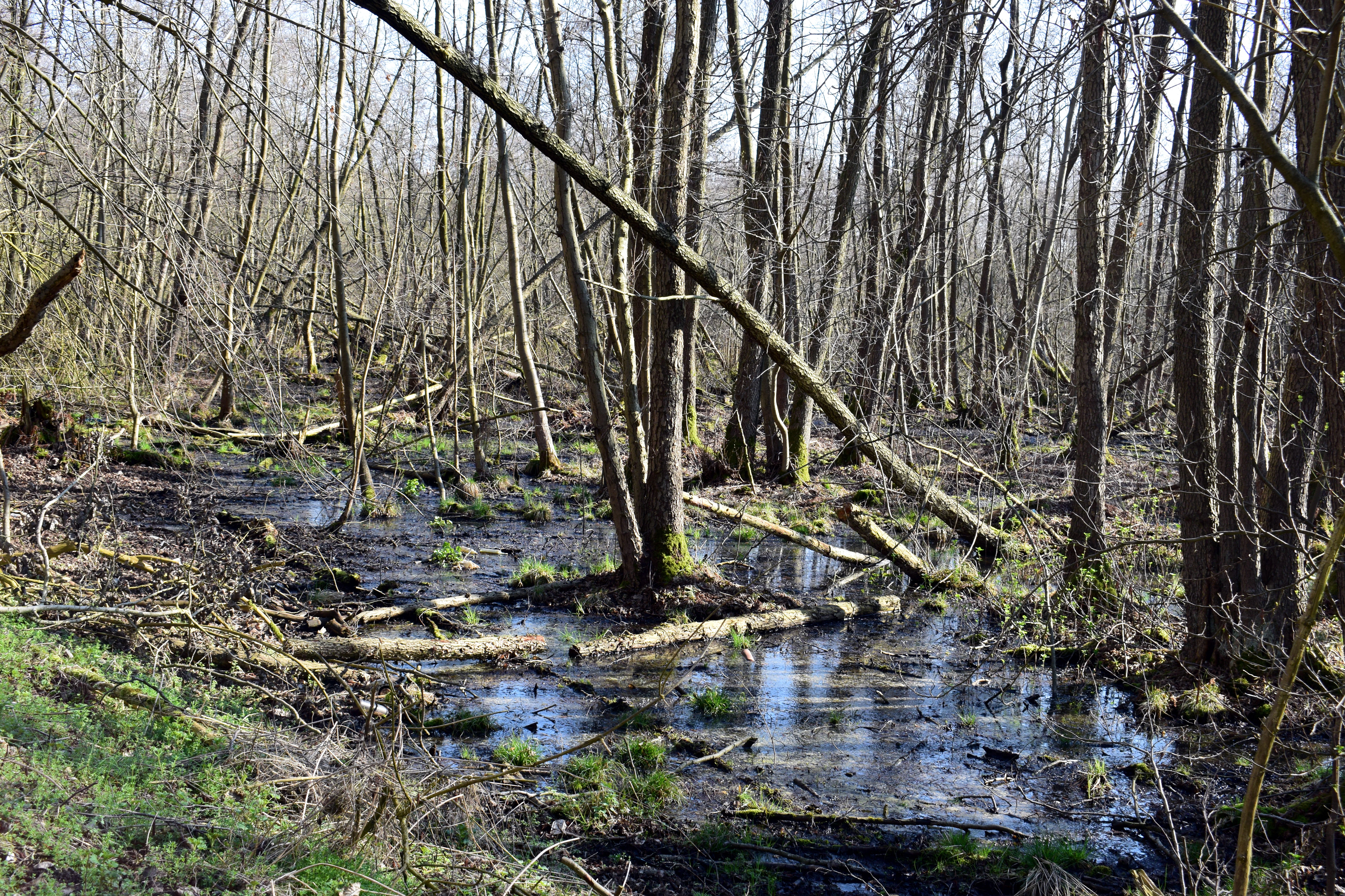
A view of a wetland forest with bare trees, fallen logs, and pools of standing water reflecting the sky.
Wetland forest landscape within the Wernsdorfer See nature reserve in Brandenburg, Germany.

Wernsdorfer See history and protected-area timeline

The landscape around Wernsdorfer See began to take shape at the end of the last Ice Age, when meltwater of the Berlin Urstromtal carved a long west-east running lowland, leaving behind sandy deposits that gradually built dunes. Over thousands of years, sand, flood-borne sediment, and dead plant material filled in the lake basin, converting parts of the original open water into fen and wet grassland between Erkner and Wernsdorf.

Humans have shaped the area for a very long time. Archaeological evidence shows that the region was inhabited during the Middle Stone Age, and Slavic settlement traces from around the fourth century remain preserved as protected ground monuments. The village of Wernsdorf itself was first documented in 1460, while neighbouring Gosen appeared in records later. On Schmettau's historical map of Brandenburg from 1575 to 1787, the lake was shown as a single, considerably larger body of water.

From the late nineteenth century, several reed-processing factories operated in the area and harvested large quantities of reed from the lake margins. As Berlin expanded in the 1920s, tourism began to replace reed harvesting as a dominant local use of the landscape. A first effort in 1936 to secure protection for the area was interrupted by the Second World War, but the district administrator of Beeskow-Storkow resumed the process in 1946. Between 1950 and 1956, Berlin household waste was dumped directly into the lake, a practice halted by conservationists in 1956. Their efforts led to the formal designation of the Naturschutzgebiet on 19 October 1967. During the 1950s a separate landfill was established east of the reserve, which was closed in 2005 due to a missing base seal and is being sealed and remediated in the 2010s. In 2004 the European Union confirmed the area as an FFH site, anchoring its protection within the Natura 2000 framework.

Wernsdorfer See landscape and geographic character

Wernsdorfer See sits in a lowland valley shaped by glacial meltwater, where the Spree and the Oder-Spree Canal run roughly parallel in a west-east direction through an otherwise gentle landscape. Elevations across the reserve range from about 30 to 45 metres above sea level, giving the terrain only modest relief but considerable ecological variety.

The most striking element is the lake itself, a shallow eutrophic waterbody that now covers roughly 75 hectares, having lost around a quarter of its former surface area to sedimentation and post-war dumping. The lake reaches maximum depths of only about 1.0 to 1.5 metres in the south and around 0.8 metres in the north, with an average surface elevation near 32.3 metres above sea level. Water enters the lake from a spring-fed pool in the north, the Kappstrom stream, and the Mühlenfließ, while the southern end connects to the nearby Krossinsee through the Oder-Spree Canal.

Around the lake, the landscape shifts quickly between habitats. Inland dunes carry open and partially open sandy grasslands with low-growing herbs, while lower-lying ground carries wet meadows, tall herb communities, and reedbeds. The interplay of dry dune sand, still water, and seasonally flooded meadows within a few hundred metres is one of the reserve's defining features and supports the diversity of plants and animals found here.

Wernsdorfer See ecosystems, habitats, and plant life

Ecologically, Wernsdorfer See is best understood as a small but layered wetland complex where glacial sand, shallow open water, reed margins, and managed grassland coexist. The combination of dry dune grassland, wet meadows, and eutrophic shallow water creates overlapping habitat types that would not normally be found side by side in lowland Brandenburg.

The reserve contains dunes with open grassy vegetation, eutrophic lakes and ponds, damp tall-herb communities, and species-rich lowland meadows that are partly maintained through traditional use. The wet meadows and stands of tall herbs are also inhabited by beaver, whose activity continues to reshape small stretches of the shoreline. As in many Spree valley reserves, water levels are partly governed by the Oder-Spree Canal, so the management of the canal has direct ecological consequences for the lake.

The botanical interest of the site is unusually high for its size. Dune and dry grassland species grow alongside wetland and aquatic species on the lake margins. Plants of conservation interest include water caltrop, the floating aquatic fern Salvinia, the fen orchid Liparis loeselii, the early marsh orchid and the broad-leaved marsh orchid, the grass-like sand sedge with dark tips, marsh gladiolus, amphibious bistort, and a range of small marshland herbs. The mixture of sand-loving and wetland-loving species in the same reserve is one of the reasons the site has been afforded both national and European protection.

Wernsdorfer See wildlife and species highlights

Wernsdorfer See is primarily known as a bird reserve. The shoreline, open water, reeds, and surrounding meadows support a wide range of breeding, resting, and feeding birds. Among regularly recorded species are hobby, bluethroat, wood sandpiper, common kingfisher, osprey, little ringed plover, common sandpiper, woodlark, northern lapwing, little crake, garganey, common crane, teal and northern shoveler, red-backed shrike, golden oriole, bittern, marsh harrier, red and black kite, black woodpecker, white-tailed eagle, great egret, barred warbler, common pochard, black tern, spotted crake, and hoopoe, reflecting a remarkably diverse mix of woodland, farmland, reedbed, and wetland species.

Mammals are represented chiefly by beaver, which is active along the wet edges of the meadows and reeds. Amphibians include moor frog, and reptiles include sand lizard. The lake itself supports fish species such as asp and bitterling, which are characteristic of slow-flowing lowland waters in the Spree system.

Conservationists have worked actively to restore two species at the site. Since 2016 artificial nest platforms have been used to encourage black terns to breed, with the first year producing a substantial count of breeding pairs that subsequently declined. From 2005 onwards, individuals of a regionally extinct butterfly, sometimes referred to as the golden checkerspot, were translocated here from a larger population near Pasewalk, and by 2009 several thousand individuals had been recorded, with the population now considered stable.

Wernsdorfer See conservation status and protection priorities

Wernsdorfer See is protected under both German and European conservation frameworks. As a Naturschutzgebiet designated in 1967, it carries the strongest level of habitat protection available under Brandenburg law. Its confirmation as an EU Fauna-Flora-Habitat site in 2004 placed it within the Natura 2000 network and tied its management to European protection objectives.

The formal conservation aims of the reserve centre on preserving the shallow lake as a refuge for water and marsh birds, maintaining habitat for feeding and breeding across many animal groups, and securing the populations of protected plants such as water caltrop, the floating fern Salvinia, and several threatened orchid species. A first draft management plan for the FFH area, produced in July 2019, reviewed the condition of habitats and species and identified fishing and angling as issues requiring clearer coordination between stakeholders.

A significant part of the conservation story is remediation. Decades of post-war dumping reduced the open water surface, while an adjacent landfill operated from the 1950s and was shut in 2005 for lacking a proper base liner, with sealing and aftercare continuing in the following decade. Active species recovery projects for black tern and the regionally extinct checkerspot butterfly show that the reserve combines passive habitat protection with more direct intervention aimed at restoring biodiversity.

Wernsdorfer See cultural meaning and human context

The region around Wernsdorfer See has been continuously occupied for thousands of years. Archaeological evidence indicates settlement during the Middle Stone Age, and Slavic settlement traces from around the fourth century remain protected as designated ground monuments. The nearby village of Wernsdorf itself was first recorded in 1460, while the village of Gosen appears in later sources. Schmettau's late-eighteenth-century map still shows the lake as a single, larger waterbody, providing a historical baseline for understanding how dramatically the landscape has changed since then.

The name Wernsdorf and the name of the lake survive as the principal cultural reference points for the reserve. While the lake is no longer used for bathing, traditional uses of the surrounding landscape, including reed harvesting in earlier centuries and the long-running agricultural use of part of the grassland, continue to shape how the area is managed today. A roughly six kilometre circular trail allows visitors to encounter these historical layers through the landscape itself.

Top sights and standout views in Wernsdorfer See

Within its compact footprint, Wernsdorfer See packs together sand dunes, dune grassland, wet meadows, reedbeds, and a shallow lake, producing a habitat mosaic that is unusual for lowland Brandenburg and particularly rich in wildlife for its size.

The reserve is a strong year-round birdwatching destination in the Berlin-Brandenburg region, combining sightings of raptors, marshland waders, and reedbed species in a single walk. Active species recovery projects, including nesting aids for black terns and a successful reintroduction of a regionally extinct checkerspot butterfly, make it a useful example of modern habitat management in action.

Best time to visit Wernsdorfer See

Because Wernsdorfer See is a lowland wetland reserve rather than a mountain or coastal park, the character of a visit changes most noticeably through the bird calendar. Spring and early summer bring the widest range of breeding birds, including cranes, bitterns, common kingfishers, and black woodpeckers, as well as flowering orchids and other dune and meadow plants on the drier ground. Late summer and autumn are often rewarding for migratory waterbirds and raptors gathering over the reeds and wet meadows, and for clearer views across the wetland as vegetation begins to die back.

Walking conditions on the roughly six kilometre circular trail are generally easiest in the drier months from late spring through early autumn, when the meadow paths are firmest. Bathing in the lake is prohibited, so visits at any time of year are best framed around walking, observing wildlife, and exploring the dunes and reed margins rather than water-based recreation.

Monthly climate preview

Measured monthly averages for temperature and precipitation across representative terrain

Wernsdorfer See Climate Normals and Long Term Temperature Rhythms

Representative coordinate records show mean temperatures ranging from sub zero winter lows to warm summer peaks alongside steady precipitation rates throughout the year. Reviewing the complete monthly climate profile reveals detailed temperature bounds and precipitation distributions for Wernsdorfer See.
Annual mean9 °C
-1 °C20 °C
Jan-1°
Feb
Mar
Apr
May14°
Jun18°
Jul20°
Aug20°
Sep15°
Oct
Nov
Dec
Warmest month
July

20.3 °C

Coolest month
January

-0.9 °C

Wettest month
July

2.4 mm/day

Driest month
April

1.1 mm/day

Park location guide

Geography guide, regional context, and park location map for Wernsdorfer See

Wernsdorfer See park geography, regions, and map view in Germany

Understand where Wernsdorfer See sits in Germany through a broader geographic reading of the surrounding landscape, nearby location context, and its mapped position within the national park landscape.

How Wernsdorfer See fits into Germany

Germany is a federal republic in Western and Central Europe with a population of over 83 million across sixteen constituent states. It is Europe's largest economy by nominal GDP and a major global exporter and importer. The capital is Berlin, and the country borders Denmark, Poland, Czech Republic, Austria, Switzerland, France, Luxembourg, Belgium, and the Netherlands.

Wider geography shaping Wernsdorfer See in Germany

Germany is located in Western and Central Europe, spanning 357,022 km². It borders Denmark to the north, Poland and the Czech Republic to the east, Austria and Switzerland to the south, and France, Luxembourg, Belgium, and the Netherlands to the west. The country has coastlines on the Baltic Sea and North Sea to the north, with the Alps located in the southern region.

Map view of Wernsdorfer See

Use this park location map to pinpoint Wernsdorfer See in Germany, understand its exact geographic position, and read its mapped placement within the surrounding landscape more clearly.

Pigeon | © OpenStreetMap contributors

Location context for Wernsdorfer See

Brandenburg

Explore protected habitats, shallow lake waters, and sandy dune grasslands.

Wernsdorfer See Photos and Landscape Scenery: Visualizing the Reserve

Visual records capture the distinctive mosaic of open water, reedbeds, and wet meadows across Wernsdorfer See. Examining field photography reveals the complex environmental character of this Brandenburg lowland nature reserve.

A view of a wetland forest with bare trees, fallen logs, and pools of standing water reflecting the sky.

A wide landscape view of a blue lake bordered by grassy banks and leafless trees under a bright blue sky.

Park atlas

Compare nearby lowland reserves, wetland habitats, and connected Brandenburg landscapes

Exploring Parks Near Wernsdorfer See and Surrounding Regional Protected Areas

Browse other protected areas and wetland reserves located near Wernsdorfer See in the surrounding Brandenburg region. Comparing adjacent lowland habitats and glacial valley geography helps place individual nature reserves into a broader regional conservation context.
A horizontal watercolor painting of a calm river or wetland area with trees, shoreline grasses, and rolling hills in the background, executed in a soft, muted style.
Nature reserveBerlin
About 2.7 km away#1 closest

North

EU-Vogelschutzgebiet Müggelspree: Protected Nature Reserve and Spree Valley Geography

Bird sanctuary and wetland landscape in southeastern Berlin

As a protected bird sanctuary within the European Natura 2000 network, the EU-Vogelschutzgebiet Müggelspree features an intricate mix of river corridors, fens, and pine forests. This reserve maintains significant ecological connectivity through the Spree lowlands, providing stable breeding and passage environments for numerous avian species. Its unique landscape architecture offers a clear view into the intersection of glacial sand formations and active floodplain ecosystems on the outskirts of Berlin.

Area
8.002 km²
Established
1997
A watercolor painting showing a soft, abstract landscape with rolling hills, a central body of water, and a tree-lined shoreline.
Nature reserveBerlin
4.9 km away#2 closest

West

Krumme Lake Nature Reserve: Geographic Overview and Protected Wetland Boundaries in Berlin

A preserved mosaic of alder swamp forest and Dahme floodplain habitat

Krumme Lake preserves a dense network of wetland habitats within the pine-dominated forests of Berlin's Treptow-Köpenick borough. This protected nature reserve integrates groundwater-influenced ecosystems and riparian forest remnants, providing a sanctuary for diverse amphibians and invertebrates that have become increasingly rare in surrounding urbanized landscapes.

Area
0.452 km²
Established
2004
IUCN
IV
Relief
Lowland
Nature reserveBerlin
6.1 km away#3 closest

Northwest

Teufelsseemoor Köpenick: Protected Kettle Bog Geography and Urban Wetland Atlas

Glacial landscape and conservation zone in Berlin, Germany

Teufelsseemoor Köpenick is a key nature reserve in Berlin that showcases the transition from post-glacial kettle hole to a thriving peatland and swamp forest. This protected area stands out for its ecological gradient and serves as a model of urban wilderness conservation. The site is defined by the contrast between its still waters and the surrounding moraine ridges of the Müggelberge.

Area
0.065 km²
Established
2016
IUCN
IV
A horizontal watercolor illustration depicting a soft, serene landscape with green trees, pink flowering trees, and gentle hills on a white background.
Nature reserveBrandenburg
7.2 km away#4 closest

South

Skabyer Torfgraben Nature Reserve: Geographic Mapping and Protected Area Overview

Wetland landscape corridors within Brandenburg, Germany

The Skabyer Torfgraben nature reserve provides a focused look at lowland stream ecosystems and rare through-flow peatland remnants. This protected area in the Dahme-Spreewald region serves as a crucial habitat mosaic, blending sandy birch-oak forests with sedge-dominated wet meadows. Examine its natural terrain and hydrological connections to the Dahme river within the context of German protected landscapes.

Area
3.049 km²
Established
1998
IUCN
IV
Relief
Lowland
Nature reserveBrandenburg
8.2 km away#5 closest

Southeast

Swatzke- und Skabyberge Nature Reserve and Protected Inland Dune Geography in Brandenburg

Mapping the sand heaths and forest ecosystems of northeastern Germany

Swatzke- und Skabyberge is a designated nature reserve in Brandenburg that preserves a rare inland dune complex. Originally shaped by long term military usage, this protected land now functions as a vital habitat for dry acid grasslands, lichen-rich pine forests, and wetland woodland fringes. It provides a unique study in how sand, fire, and moisture processes maintain biodiversity within the lowland German landscape.

Area
5.2 km²
Established
1999
IUCN
IV
Nature reserveBrandenburg
9.3 km away#6 closest

South

Tiergarten Nature Reserve: Geography and Protected Habitat Mapping in Brandenburg, Germany

Ancient oak woodland, riparian wetlands, and historic forest trails.

Spanning 158 hectares, the Tiergarten nature reserve serves as an ecologically rich sanctuary of oak-hornbeam forests and wet meadows. This area, formerly a royal hunting ground, offers a dense mosaic of riparian zones along the Staabe river, protecting essential habitats within the broader Brandenburg landscape.

Area
1.58 km²
Established
1995
IUCN
IV
A soft watercolor illustration of a lowland wetland landscape with a small pool of water, grasses, and scattered trees under a light sky.
Nature reserveBrandenburg
About 9.4 km away#7 closest

West

Flutgrabenaue Waltersdorf Nature Reserve: Protected Wetland Geography and Regional Atlas

A significant floodplain sanctuary in the Brandenburg lowlands.

Flutgrabenaue Waltersdorf represents an ecologically rich lowland floodplain featuring sinuous watercourses, alder swamps, and traditional meadow habitats. Located south of Berlin, this reserve provides a vital geographic contrast to the urbanized infrastructure of the Brandenburg region. Use this overview to study the boundary, terrain characteristics, and regional importance of this protected marshland landscape.

Area
2.88 km²
Established
1998
IUCN
IV
Relief
Lowland
Nature reserveBrandenburg
13 km away#8 closest

South

Dolgensee Nature Reserve: Mapped Protected Landscapes and Wetland Geography in Brandenburg, Germany

Protected lake basin, reedbeds, and inland dune grassland

Located in the Brandenburg state of Germany, Dolgensee Nature Reserve offers a rare mosaic of wetland and dry grassland habitats. The site centers on a nutrient-rich lake basin featuring extensive reedbeds and alder swamp, which transitions into open inland dune ecosystems. This protected area represents a significant example of natural lake basin preservation within the larger Dahme-Heideseen landscape, providing a crucial habitat for various waterbird and aquatic wildlife species.

Area
3.085 km²
Established
1995
IUCN
IV
Relief
Lowland

Common questions about visiting, size, designation, and location context for Wernsdorfer See

Wernsdorfer See FAQs for park facts, access, geography, and protected area context

Find quick answers about Wernsdorfer See, including protected-area facts, park geography, trail and visitor context, and how the park fits into its surrounding country and regional landscape.
MoriAtlas Explorer

Continue Your Protected Areas Search Across the Global Atlas

Deepen your exploration by continuing the structured search for national parks and protected areas worldwide. Utilize the comprehensive filtering capabilities to compare different conservation landscapes and refine your understanding of global park geography. Discover more about the distribution and characteristics of protected natural areas.

Global natural geography