Mori Atlas logo
Nature reserveSwatzke- und Skabyberge

Analyzing the ecological mosaic of dry sandy heaths, lichen pine forests, and bog woodland margins

Swatzke- und Skabyberge Nature Reserve: An Inland Dune Protected Landscape in Brandenburg, Germany

(Naturschutzgebiet Swatzke- und Skabyberge)

Swatzke- und Skabyberge stands as a significant nature reserve within the Oder-Spree district of Brandenburg, representing one of the region's most distinctive inland sand ecosystems. This former military training ground now supports a complex mosaic of acid habitat types, including expansive sand heaths, dry silver-grass grasslands, and transitional mire remnants. The terrain features gentle ridges and moist depressions that illustrate the intersection of historical land use and natural conservation within the lowland geography of northeastern Germany.

inland dunessand heathdry grasslandlichen pine forestbog woodlandtransitional mire

Swatzke- und Skabyberge

Nature reserve

Park overview

Structured park overview, official facts, and landscape profile for Swatzke and Skabyberge Nature Reserve

Swatzke and Skabyberge Nature Reserve park facts, protected area profile, and essential visitor context

Review the core facts for Swatzke and Skabyberge Nature Reserve, including designation, size, terrain, visitor scale, habitats, and operating context in one park-focused overview.

About Swatzke and Skabyberge Nature Reserve

Swatzke and Skabyberge lies in the southeast of Brandenburg, in a region shaped by glacial sand deposits drained by the Spree river and its associated canal system. It is a low-relief landscape by any standard: the highest points of the Swatzkeberge reach only around 51 meters above sea level, and the neighboring Kleine Skabyberge top out at about 50.8 meters, yet those modest elevations are enough to anchor one of the more ecologically distinctive sites in the Oder-Spree district.

The reserve covers about 520 hectares of a historically military-used area that, after decades of disturbance by armored vehicles and troop movements, has re-developed into an unusually well-preserved mosaic of inland dune habitats. The site's character is defined by contrast: dry and wet, open and forested, acid sand soils on the ridges and peaty moors in the depressions between them. Where the water table is highest, the depressions hold transitions into floating bog communities, bog woodlands, and small fringe mires that grade into the surrounding pine forest.

Its protected status is modern but thorough. The area was placed under formal nature protection in 1999 and has been integrated into the European Natura 2000 network as a Fauna-Flora-Habitat site, recognizing the quality and extent of its dune, heath, and pine forest habitat types. Today the reserve functions as a sanctuary where natural sand dynamics, slow forest succession, and traditional open-ground disturbance regimes together maintain a sand-ecosystem landscape that increasingly rare in central Europe.

Quick facts and research context for Swatzke and Skabyberge Nature Reserve

Swatzke and Skabyberge is a nature reserve in Brandenburg, Germany, located in the municipality of Spreenhagen in the Oder-Spree district, just south of Hartmannsdorf and north of the A12 motorway. The full protected area covers roughly 520 hectares, of which about 459 hectares are designated as a Natura 2000 Fauna-Flora-Habitat (FFH) site under the EU Habitats Directive. The reserve was placed under legal protection by decree dated 11 October 1999, and is managed as an IUCN Category IV Habitat/Species Management Area. Designated number 1537, it is part of the European ecological network Natura 2000 for its inland dunes, dry heaths, and lichen pine forests.

Protection and recognition

Examining official conservation records, management frameworks, and international designations.

Swatzke- und Skabyberge Protection Status and Natura 2000 Recognition

Swatzke- und Skabyberge maintains documented protection status supported by official Natura 2000 recognition records. Structured datasets aggregate baseline conservation metrics to clarify international designations and administrative scope.
Park context

Deeper park guide and search-rich context for Swatzke and Skabyberge Nature Reserve

Swatzke and Skabyberge Nature Reserve history, landscape, wildlife, and travel context

Explore Swatzke and Skabyberge Nature Reserve through its history, landscape character, ecosystems, wildlife, conservation priorities, cultural context, and seasonal travel timing in a structured park guide built for atlas discovery and search intent.

Why Swatzke and Skabyberge Nature Reserve stands out

The reserve is best known for its inland dune complex, a large tract of former military training ground that has become an extensive area of sand heath with broom and gorse, dry grasslands, and natural Central European lichen pine forests. These dry, acid sand habitats are uncommon in Brandenburg and form the defining ecological identity of the site, complemented by small transitional mire and bog woodland margins along the lower ground.
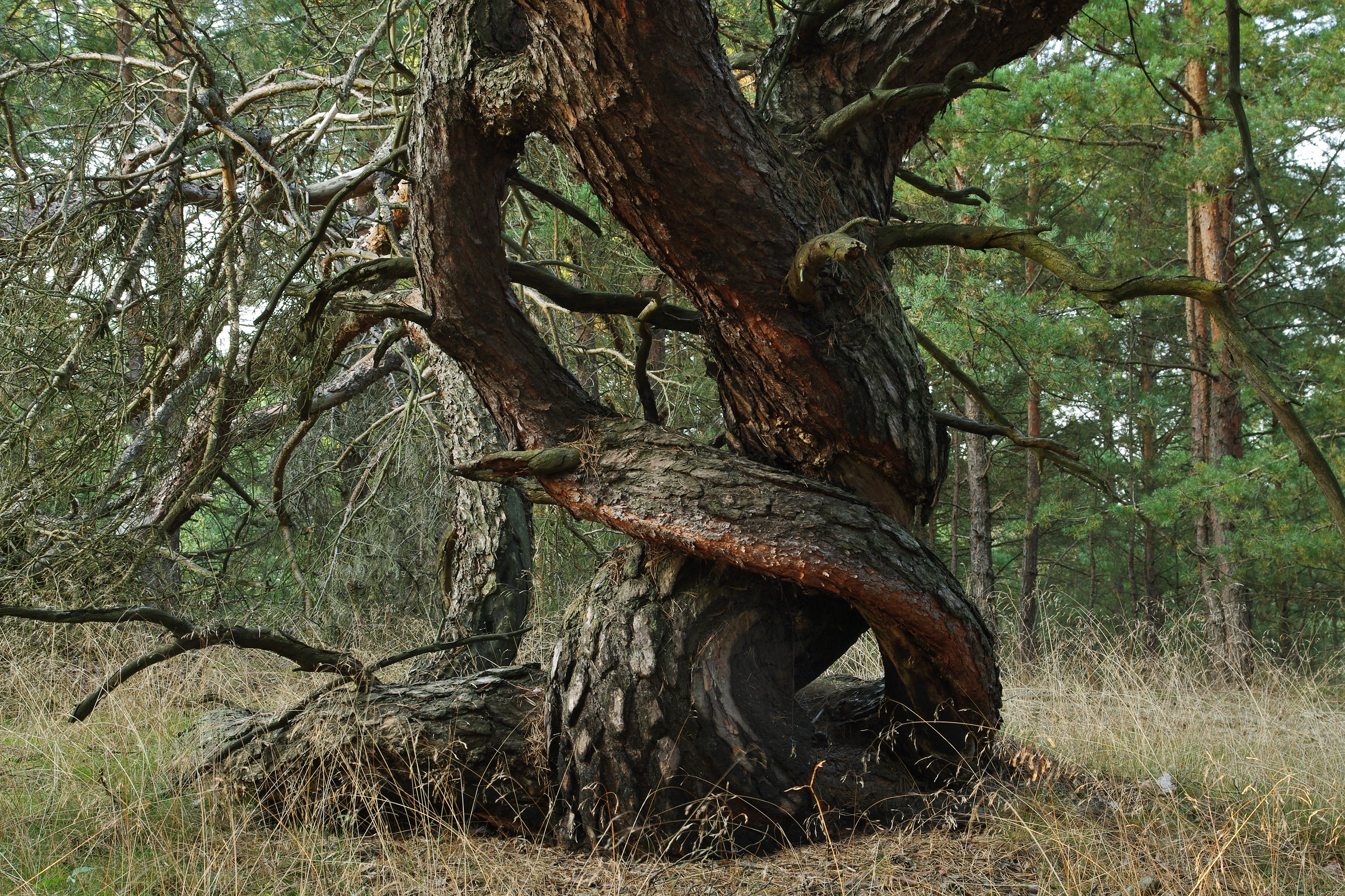
A close up view of a gnarled pine tree trunk with twisted, textured bark in a dry, sandy pine forest setting.
A gnarled pine tree in the Swatzke- und Skabyberge nature reserve.

Swatzke and Skabyberge Nature Reserve history and protected-area timeline

The modern history of the Swatzke and Skabyberge landscape is inseparable from its long use as a military training area. During the Cold War period the area served as a Truppenübungsplatz, a troop training ground, for the Western Group of Soviet Forces (WGT) stationed in East Germany, and vehicle movements, track laying, and other training activity kept the sandy ground open at a time when much of the surrounding region was being afforested.

The end of that military use marked a turning point for conservation. After German reunification and the withdrawal of Soviet forces, the property's biological value became apparent. The Brandenburg state authorities placed the area under formal protection through the Verordnung über das Naturschutzgebiet "Swatzke- und Skabyberge" of 11 October 1999, assigning it designation number 1537. Shortly afterwards it was incorporated into the Natura 2000 network as an FFH site (site code 3649-301), under the Habitats Directive (Council Directive 92/43/EEC). The reserve is now administered by the Brandenburg State Office for the Environment as a Habitat/Species Management Area, classified at IUCN Category IV, with active management to restore and maintain open sand habitats.

Swatzke and Skabyberge Nature Reserve landscape and geographic character

The landscape of Swatzke and Skabyberge is a classic Brandenburg inland dune terrain, with gentle sandy ridges, dry valleys, and shallow peat-filled depressions. The ground rises only modestly: the Swatzkeberge reach about 51 meters above sea level and the Kleine Skabyberge about 50.8 meters, but even these small heights cast the ecological template of the area, because the sandy slopes dry out quickly while the hollows between them remain moist.

To the north of the reserve lies the Oder-Spree Canal and, further north, the Spree river itself. The eastern edge runs along the L23 state road, and the southern boundary is defined in part by the A12 motorway. To the northwest lies the Triebschsee, another nature reserve, while the Skabyer Torfgraben rises south of the hills and flows north and east to eventually empty into the Dahme river downstream. The result is a small but ecologically rich land parcel that sits inside a broader matrix of lowland Brandenburg forest, canal systems, and former military grounds.

Swatzke and Skabyberge Nature Reserve ecosystems, habitats, and plant life

Ecologically, Swatzke and Skabyberge is remarkable for the way a small piece of ground packs together an unusually complete sequence of inland sand habitats. The dune ridges carry dry, acid, leached soils that support sand heath communities with heather and broom-gorse scrub, and open silver-grass and bent-grass dry grasslands (the Cornephorus-Agrostis grasslands), all recognized as priority inland dune habitats in the European Habitats Directive.

Open sand and heath here grade naturally into Central European lichen pine forests, a special forest community shaped by long-term ecological continuity, dry conditions, and nutrient-poor soil. In the wetter depressions and along the margins, the habitat mix shifts sharply: the site includes transitions into floating bog and quaking mires (Caricion lasiocarpae and Rhynchosporion albae vegetation, coded 7140 in the Natura 2000 system) and patches of bog woodland (coded 91D0). The reserve's five listed habitat types therefore range from very dry to very wet, producing a tight ecological mosaic that is unusually complete for this part of Germany.

Swatzke and Skabyberge Nature Reserve wildlife and species highlights

While the reserve is best characterized by its habitats rather than by headline species, its ecological integrity supports characteristic assemblages of dry-sand and pine-forest fauna. Among mammals, the reserve lists Myotis myotis, the greater mouse-eared bat, as a species protected under Annex II of the Habitats Directive along with its important foraging, breeding, migration, and wintering habitats.

Swatzke and Skabyberge Nature Reserve conservation status and protection priorities

Swatzke and Skabyberge holds a clear conservation significance that extends well beyond its modest size. The site is part of the coherent European Natura 2000 ecological network, formally recognized as a Fauna-Flora-Habitat site of approximately 459 hectares, and designated as a national nature reserve (Naturschutzgebiet) with a larger buffer area of about 520 hectares in total.

Its conservation value rests on the unusual completeness of its inland-dune ecosystem: dry inland dune heaths, dry grasslands, natural Central European lichen pine forests, and small bog and mire communities all occur within a compact block once shaped by military use but now allowed to develop toward a more natural state. As an IUCN Category IV Habitat/Species Management Area, the site is actively managed to maintain and restore these open sand habitats, preventing succession toward uniform closed forest and preserving the mosaic that gives the reserve its distinctiveness.

Swatzke and Skabyberge Nature Reserve cultural meaning and human context

The reserve's identity is closely bound up with the regional history of eastern Brandenburg and the legacy of late twentieth-century military use. For decades the sandy ridges of the Swatzkeberge and Kleine Skabyberge functioned as a Soviet training ground, and the disturbance regime that resulted, compacted ground, vehicle tracks, and artificially maintained open sand, paradoxically preserved the open character of the dunes that now anchors their ecological value.

Today the site sits within the rural landscape around Spreenhagen, bordered by reclaimed military land, canals constructed and modified during the period of industrial waterway use, and the small agricultural settlements of the Oder-Spree region. The transformation from restricted military zone to public nature reserve fits a broader pattern across the former East German military belt, where former training areas have become some of the most important refuges for open sand and heath ecosystems in central Europe.

Top sights and standout views in Swatzke and Skabyberge Nature Reserve

The Swatzke and Skabyberge reserve concentrates five protected habitat types within a compact 459-hectare Natura 2000 block: dry inland dune heaths of heather and gorse, natural silver-grass dry grasslands, Central European lichen pine forests, and small transitional mire and bog woodland on the wetter ground. It is also one of a small set of Brandenburg reserves whose contemporary ecological identity was directly shaped by the area's past as a Soviet training ground.

Best time to visit Swatzke and Skabyberge Nature Reserve

The reserve is most rewarding in late spring through early autumn, when dry sand heaths and open grasslands are at their most diverse, woodland paths are dry underfoot, and birds and insects associated with open dune habitats are most active. Cooler months still offer quiet, contemplative pine-forest walking, but the dune grasslands and heaths are at their visual and ecological peak in the warmer half of the year.

Monthly climate preview

Long-term monthly averages and representative coordinates across Brandenburg geography

Swatzke und Skabyberge Climate Normals, Annual Temperature and Precipitation Patterns

Representative point measurements reveal the long-term annual temperature and precipitation rhythm across Swatzke und Skabyberge, establishing baseline environmental normals from historical climate data. Complete monthly breakdowns provide deeper comparative context for examining year-round temperature variations and precipitation trends across the protected terrain.
Annual mean9 °C
-1 °C20 °C
Jan-1°
Feb
Mar
Apr
May14°
Jun18°
Jul20°
Aug20°
Sep15°
Oct
Nov
Dec
Warmest month
July

20.3 °C

Coolest month
January

-0.9 °C

Wettest month
July

2.4 mm/day

Driest month
April

1.1 mm/day

Park location guide

Geography guide, regional context, and park location map for Swatzke and Skabyberge Nature Reserve

Swatzke and Skabyberge Nature Reserve park geography, regions, and map view in Germany

Understand where Swatzke and Skabyberge Nature Reserve sits in Germany through a broader geographic reading of the surrounding landscape, nearby location context, and its mapped position within the national park landscape.

How Swatzke and Skabyberge Nature Reserve fits into Germany

Germany is a federal republic in Western and Central Europe with a population of over 83 million across sixteen constituent states. It is Europe's largest economy by nominal GDP and a major global exporter and importer. The capital is Berlin, and the country borders Denmark, Poland, Czech Republic, Austria, Switzerland, France, Luxembourg, Belgium, and the Netherlands.

Wider geography shaping Swatzke and Skabyberge Nature Reserve in Germany

Germany is located in Western and Central Europe, spanning 357,022 km². It borders Denmark to the north, Poland and the Czech Republic to the east, Austria and Switzerland to the south, and France, Luxembourg, Belgium, and the Netherlands to the west. The country has coastlines on the Baltic Sea and North Sea to the north, with the Alps located in the southern region.

Map view of Swatzke and Skabyberge Nature Reserve

Use this park location map to pinpoint Swatzke and Skabyberge Nature Reserve in Germany, understand its exact geographic position, and read its mapped placement within the surrounding landscape more clearly.

Pigeon | © OpenStreetMap contributors

Location context for Swatzke and Skabyberge Nature Reserve

Brandenburg

Explore inland dune terrain, sand heath, and lichen pine forest imagery.

Swatzke- und Skabyberge Photos and Landscape Scenery Visual Guide

Visual documentation captures the unique topography and rare habitat mosaic of Swatzke- und Skabyberge across sandy ridges and moist depressions. Photographic archives reveal the distinct environmental character of protected inland dune ecosystems and lowland Brandenburg wilderness.

A close up view of a gnarled pine tree trunk with twisted, textured bark in a dry, sandy pine forest setting.

Park atlas

Compare surrounding lowland reserves and regional protected landscapes

Explore Protected Areas and Parks Near Swatzke- und Skabyberge

Discover adjacent nature reserves and protected habitats situated within the broader Brandenburg lowland ecosystem. Continued geographic comparison reveals the diverse regional network of inland dunes, pine forests, and wetland reserves surrounding Swatzke- und Skabyberge.
A horizontal watercolor illustration depicting a soft, serene landscape with green trees, pink flowering trees, and gentle hills on a white background.
Nature reserveBrandenburg
3.2 km away#1 closest

Southwest

Skabyer Torfgraben Nature Reserve: Geographic Mapping and Protected Area Overview

Wetland landscape corridors within Brandenburg, Germany

The Skabyer Torfgraben nature reserve provides a focused look at lowland stream ecosystems and rare through-flow peatland remnants. This protected area in the Dahme-Spreewald region serves as a crucial habitat mosaic, blending sandy birch-oak forests with sedge-dominated wet meadows. Examine its natural terrain and hydrological connections to the Dahme river within the context of German protected landscapes.

Area
3.049 km²
Established
1998
IUCN
IV
Relief
Lowland
A wide watercolor illustration showing a calm lake with small tree-covered islands, bordered by green forests and distant hills under a pale sky.
Protected areaBrandenburg
8.2 km away#2 closest

Northwest

Wernsdorfer See Protected Area: Geographic Mapping and Landscape Context in Brandenburg

Glacial wetland mosaic featuring dunes and reedbeds

Wernsdorfer See is an essential nature reserve in Brandenburg that showcases a rare mix of habitats, from open sandy dunes and grasslands to shallow marshland and reedbeds. Managed as part of the Natura 2000 network, the site serves as a vital refuge for bird species and rare wetland flora. This overview traces the geography and terrain of the Spree valley lowland, offering a structured perspective on its conservation landscape.

Area
1.387 km²
Established
1967
Relief
Lowland
Climate
Temperate
Nature reserveBrandenburg
8.9 km away#3 closest

Southwest

Dolgensee Nature Reserve: Mapped Protected Landscapes and Wetland Geography in Brandenburg, Germany

Protected lake basin, reedbeds, and inland dune grassland

Located in the Brandenburg state of Germany, Dolgensee Nature Reserve offers a rare mosaic of wetland and dry grassland habitats. The site centers on a nutrient-rich lake basin featuring extensive reedbeds and alder swamp, which transitions into open inland dune ecosystems. This protected area represents a significant example of natural lake basin preservation within the larger Dahme-Heideseen landscape, providing a crucial habitat for various waterbird and aquatic wildlife species.

Area
3.085 km²
Established
1995
IUCN
IV
Relief
Lowland
A watercolor illustration of an open dune landscape with soft yellow sand, green grass, and scattered trees under a light sky.
Nature reserveBrandenburg
9.3 km away#4 closest

Southeast

Binnendüne Waltersberge: Nature Reserve and Glacial Landscape in Brandenburg

Exploring inland sand dune geography and protected habitat boundaries.

Binnendüne Waltersberge is a significant nature reserve representing the glacial history of Brandenburg. Its terrain features a wave-like sand ridge that contrasts bare, sun-exposed surfaces with lichen-rich pine forests. This site serves as an essential example of psammophilic ecosystem restoration and regional geomorphology within the Oder-Spree landscape.

Area
0.14 km²
Established
1990
Relief
Upland
Climate
Temperate
Nature reserveBrandenburg
9.6 km away#5 closest

Southeast

Groß Schauener Seenkette Nature Reserve: Mapped Wetlands and Brandenburg Lake Geography

An undisturbed chain of shallow lakes and protected fen landscapes

This protected nature reserve in Brandenburg preserves a vital chain of six interconnected lakes. The geography is defined by extensive reedbeds, sedge stands, and rare inland saline meadows, providing a crucial habitat mosaic. Learn how these wetlands connect to the surrounding Dahme-Heideseen region through a network of terrain-focused conservation areas and historic trails.

Area
21.249 km²
Established
2000
Relief
Lowland
Climate
Temperate
Nature reserveBrandenburg
11 km away#6 closest

West

Tiergarten Nature Reserve: Geography and Protected Habitat Mapping in Brandenburg, Germany

Ancient oak woodland, riparian wetlands, and historic forest trails.

Spanning 158 hectares, the Tiergarten nature reserve serves as an ecologically rich sanctuary of oak-hornbeam forests and wet meadows. This area, formerly a royal hunting ground, offers a dense mosaic of riparian zones along the Staabe river, protecting essential habitats within the broader Brandenburg landscape.

Area
1.58 km²
Established
1995
IUCN
IV
A horizontal watercolor painting of a calm river or wetland area with trees, shoreline grasses, and rolling hills in the background, executed in a soft, muted style.
Nature reserveBerlin
About 11 km away#7 closest

Northwest

EU-Vogelschutzgebiet Müggelspree: Protected Nature Reserve and Spree Valley Geography

Bird sanctuary and wetland landscape in southeastern Berlin

As a protected bird sanctuary within the European Natura 2000 network, the EU-Vogelschutzgebiet Müggelspree features an intricate mix of river corridors, fens, and pine forests. This reserve maintains significant ecological connectivity through the Spree lowlands, providing stable breeding and passage environments for numerous avian species. Its unique landscape architecture offers a clear view into the intersection of glacial sand formations and active floodplain ecosystems on the outskirts of Berlin.

Area
8.002 km²
Established
1997
A watercolor painting showing a soft, abstract landscape with rolling hills, a central body of water, and a tree-lined shoreline.
Nature reserveBerlin
14 km away#8 closest

Northwest

Krumme Lake Nature Reserve: Geographic Overview and Protected Wetland Boundaries in Berlin

A preserved mosaic of alder swamp forest and Dahme floodplain habitat

Krumme Lake preserves a dense network of wetland habitats within the pine-dominated forests of Berlin's Treptow-Köpenick borough. This protected nature reserve integrates groundwater-influenced ecosystems and riparian forest remnants, providing a sanctuary for diverse amphibians and invertebrates that have become increasingly rare in surrounding urbanized landscapes.

Area
0.452 km²
Established
2004
IUCN
IV
Relief
Lowland

Common questions about visiting, size, designation, and location context for Swatzke and Skabyberge Nature Reserve

Swatzke and Skabyberge Nature Reserve FAQs for park facts, access, geography, and protected area context

Find quick answers about Swatzke and Skabyberge Nature Reserve, including protected-area facts, park geography, trail and visitor context, and how the park fits into its surrounding country and regional landscape.
MoriAtlas Explorer

Continue Your Protected Areas Search Across the Global Atlas

Deepen your exploration by continuing the structured search for national parks and protected areas worldwide. Utilize the comprehensive filtering capabilities to compare different conservation landscapes and refine your understanding of global park geography. Discover more about the distribution and characteristics of protected natural areas.

Global natural geography