Mori Atlas logo
Nature reserveGroß Schauener Seenkette

Mapping the six interconnected lakes, fens, and rare saline meadows within the Brandenburg region

Groß Schauener Seenkette: A Comprehensive Protected Nature Reserve and Wetland Landscape Atlas

(Naturschutzgebiet Groß Schauener Seenkette)

Groß Schauener Seenkette represents a significant protected nature reserve in Brandenburg, Germany, encompassing a chain of six shallow lakes and surrounding mire ecosystems. This geographic atlas entry provides a detailed look at the wetland mosaic, including the rare inland saline meadows at Marstallwiesen. By tracing these protected boundaries, visitors can better understand the lowland lake terrain and the quiet aquatic corridors that support sensitive species within the wider Dahme-Heideseen landscape.

lake chainshallow lakeswetlandsreedbedswet meadowsfen and mire

Groß Schauener Seenkette

Nature reserve

Park overview

Structured park overview, official facts, and landscape profile for Groß Schauener Seenkette

Groß Schauener Seenkette park facts, protected area profile, and essential visitor context

Review the core facts for Groß Schauener Seenkette, including designation, size, terrain, visitor scale, habitats, and operating context in one park-focused overview.

About Groß Schauener Seenkette

The Groß Schauener Seenkette is a nature reserve in Brandenburg, eastern Germany, defined above all by a string of six shallow, lowland lakes that together form one of the more intact freshwater wetland complexes in the region. The protected area lies in the district of Oder-Spree, within the municipality of Storkow (Mark), where it sits inside the broader Dahme-Heideseen Nature Park. Its official designation as a Naturschutzgebiet dates from 27 April 2000, and the entire reserve covers around 2,125 hectares of lakes, reed belts, wet meadows, forest mires, and transitional bog.

The lake chain itself runs roughly north to south and comprises six named waters: Schaplowsee, Großer Schauener See, Großer Wochowsee, Großer Selchower See, Schweriner See, and Bugker See. Each of these lakes touches one of the surrounding villages, including Groß Schauen, Wochowsee, Selchow, Schwerin, and Bugk, which gives the reserve a particular relationship with the local rural communities. In 2002, the Heinz Sielmann Foundation, a major German conservation foundation, purchased the lakes and a substantial part of the surrounding land, creating the area now called Sielmanns Naturlandschaft Groß Schauener Seen.

The defining value of the Seenkette lies in its ecological intactness. Because the lakes are shallow and the surrounding land has been spared from major development, the reserve supports reedbeds, floating and emergent aquatic plants, rare marsh orchids, sundews, royal fern, and pockets of inland saline habitat on the Marstallwiesen north of Schaplowsee. Together with adjacent fens and forest mires, this mosaic makes the area one of the more important wetland refuges in southern Brandenburg, and a key piece of the larger network of protected areas in Oder-Spree.

Protection and recognition

Terrestrial conservation history and verified Natura 2000 framework details

Groß Schauener Seenkette Protection Status and Designated Recognition Records

Groß Schauener Seenkette holds documented terrestrial protection status established in the year 2000 alongside verified Natura 2000 recognition records. Structured conservation metrics outline management scope and official designation history for regional analysis.

International recognition

Protection details

Protection scope
Terrestrial
Designated year
2000
Transboundary protection
No
Park context

Deeper park guide and search-rich context for Groß Schauener Seenkette

Groß Schauener Seenkette history, landscape, wildlife, and travel context

Explore Groß Schauener Seenkette through its history, landscape character, ecosystems, wildlife, conservation priorities, cultural context, and seasonal travel timing in a structured park guide built for atlas discovery and search intent.

Why Groß Schauener Seenkette stands out

The reserve is best known for its undisturbed chain of shallow lakes, bordering fens and wet meadows, and for the surprisingly rich waterbird and amphibian fauna that this quiet Brandenburg landscape still supports.
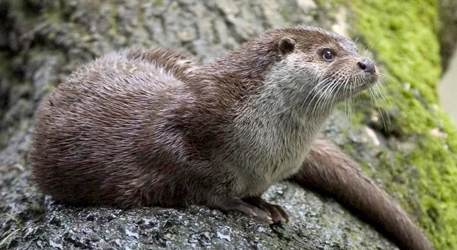
A close-up view of a European otter with brown fur and white whiskers resting on a moss-covered tree trunk.
A European otter resting on a mossy log within the Groß Schauener Seenkette nature reserve.

Groß Schauener Seenkette history and protected-area timeline

Although the lakes themselves are natural features of the Brandenburg glacial landscape, their modern significance as a nature reserve is comparatively recent. The Groß Schauener Seenkette was formally designated as a protected Naturschutzgebiet on 27 April 2000, bringing the lakes and the surrounding fens, wet meadows, and forested mires under a unified conservation framework.

Two years later, in 2002, the Heinz Sielmann Foundation acquired the lakes and a substantial portion of the surrounding land. This purchase effectively removed a large part of the reserve from purely commercial or agricultural use and created the long-term stewardship zone now known as Sielmanns Naturlandschaft Groß Schauener Seen. The acquisition also aligned the area with the wider goals of the foundation, which operates several large conservation landscapes across Germany.

The reserve is also embedded in a broader regional landscape. It lies within the Naturpark Dahme-Heideseen, a sprawling nature park that connects numerous lakes, forests, and wetland areas in southern Brandenburg. Within this regional framework, the Groß Schauener Seenkette functions both as a standalone wetland sanctuary and as a node in a wider network of protected lowland lakes, mires, and forest patches extending toward the Spree river system.

Groß Schauener Seenkette landscape and geographic character

The landscape of the Groß Schauener Seenkette is shaped by the low-relief, glacially formed terrain typical of southern Brandenburg. The reserve is built around six shallow lakes that line up in a chain running roughly north to south across the Storkow area. Their shallow profiles leave wide, soft shorelines that are fringed with reedbeds, sedge stands, and floating mats of water lilies and yellow pond lilies, giving the waters an intensively vegetated, almost lacustrine character rather than that of open deepwater lakes.

Around the lakes the terrain transitions into a mosaic of wet meadows, fens, and forest mires. These flat, waterlogged zones are broken up by patches of damp woodland and floating bog vegetation, while scattered reed beds and sedge meadows fill the lower-lying basins. A particularly unusual feature is the inland saline site known as the Marstallwiesen north of Schaplowsee, where salt-influenced soils produce a specialised sward of halophytic plant species that is very rare inland in Germany.

The wider setting is the gently undulating countryside of the Dahme-Heideseen region, where chains of lakes, pine and mixed forest stands, and small rural villages alternate. Because the Seenkette is sheltered from dense settlement and industrial development, the broader landscape around the reserve still reads as a quiet, lakes-dominated rural mosaic characteristic of eastern Brandenburg.
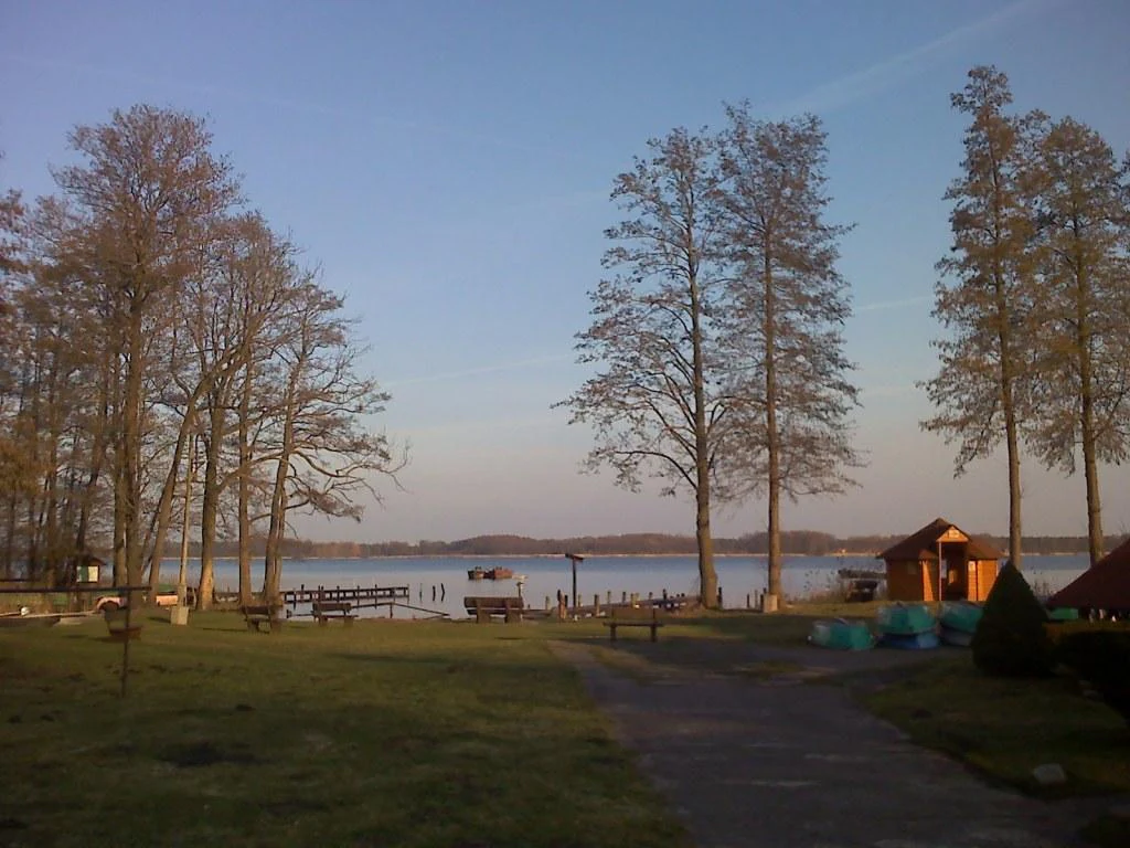
A lakeshore scene featuring tall deciduous trees, a wooden structure, a small pier, and benches overlooking the water at sunset.
A view of the Gross Schauener See from the shoreline near the Kollnitz fishery.

Groß Schauener Seenkette ecosystems, habitats, and plant life

Ecologically, the Groß Schauener Seenkette is a wetland-dominated system whose identity rests on the interaction between shallow open water, reed fringe, wet meadow, fen, and forest mire. The shallow basin of each lake supports extensive beds of white and yellow water lilies, water arum (Sumpf-Calla), marsh iris, marsh orchids, sundews, and royal fern along the margins, with the resulting gradient from open water through floating and emergent vegetation into saturated peatland forming the core ecological gradient of the reserve.

The wet meadows and fens around the lakes harbour typical lowland mire vegetation, including sedges, reeds, and moisture-loving herbs. These open wetland habitats are complemented by wet woodland and bog forest on the poorer, peatier soils. The most botanically distinctive element is the inland saline grassland at the Marstallwiesen, which adds a halophytic flora to an otherwise freshwater wetland assemblage and gives the reserve an unusually broad ecological spectrum for its size.

The hydrology of the chain is also central to its nature. Because the lakes remain shallow and strongly connected to fluctuating groundwater, seasonal water-level changes shape both the shape of reedbeds and the composition of the wet meadows, periodically opening up new muddy shorelines that are important for wading birds and amphibians. This dynamic wetland character is one of the chief reasons the reserve has retained such a rich suite of species.

Groß Schauener Seenkette wildlife and species highlights

The Groß Schauener Seenkette is primarily a waterbird and wetland wildlife area. The lakes and their fringing reedbeds support breeding populations of bittern, great crested grebe, mute swan, and greylag goose, while the broader wetland mosaic functions as a staging and wintering site for migratory waterbirds. The conspicuous power-line pylons standing in the surrounding landscape are regularly used as nest platforms by ospreys, giving visitors a good chance of seeing these large fish-eagles hunting over the lakes during the breeding season.

Reptiles and amphibians are particularly well represented around the shallow waters. Water frogs and common toads are joined by the endangered fire-bellied toad and, more unusually, the smooth snake, a rare and easily overlooked reptile in Brandenburg. Grass snakes hunt along the margins, completing a herpetofauna typical of undisturbed lowland wetland in eastern Germany.

The mammal fauna of the reserve is also notable. The undisturbed quality of the lake system and its surrounding mires has allowed the Eurasian otter to maintain a presence along the waterway chain, and otters are recorded using the lakes as part of a wider territory that includes the surrounding forest and wetland. Roe deer and other typical Brandenburg woodland mammals also make use of the wet woodland edges, but it is the combination of wetland birds, amphibians, and otters that defines the reserve's wildlife identity.

Groß Schauener Seenkette conservation status and protection priorities

The conservation significance of the Groß Schauener Seenkette rests on its formal protection as a Naturschutzgebiet since 2000 and on the long-term stewardship the area has received since 2002, when the Heinz Sielmann Foundation acquired the lakes and a major part of the surrounding land. That acquisition effectively converted a large portion of the wetland from potentially vulnerable private use into a permanently managed conservation zone, now known as Sielmanns Naturlandschaft Groß Schauener Seen.

Within the regional conservation framework, the reserve is part of the Dahme-Heideseen Nature Park and contributes to a broader network of protected wetland sites across Landkreis Oder-Spree, alongside areas such as Trautzke-Seen und Moore and the Storkower Kanal reserve. Its shallow lakes, reed belts, fens, and inland saline meadows together protect a coherent mosaic of freshwater and halophytic habitats that is increasingly rare in central Europe.

The reserve is also recognised for hosting species that depend on undisturbed lowland wetland, including breeding bitterns, ospreys, fire-bellied toads, smooth snakes, and otters. Maintaining the current hydrology, restricting harmful land-use, and preserving the inland saline grassland of the Marstallwiesen are central to ensuring that the Seenkette retains its ecological integrity into the future.

Groß Schauener Seenkette cultural meaning and human context

The reserve is closely interwoven with the rural communities along its shores. The lakes border the villages of Groß Schauen, Wochowsee, Selchow, Schwerin, and Bugk, and traditional local uses of the water, including a working fishery on the Großer Schauener See (operated by Fischerei Köllnitz), still coexist with the conservation framework.

A second cultural strand is the historical Salzweg, an 8.5-kilometre themed trail that begins at Storkow Castle and runs through Philadelphia and Groß Schauen down to the lake chain. The trail links the reserve to the region’s salt-related heritage and to the unusual inland saline landscape at the Marstallwiesen, which were historically associated with traditional salt-meadow land use. Today this legacy is reinterpreted through four information points that explain the cultural and ecological story of inland saline habitats.

Top sights and standout views in Groß Schauener Seenkette

The highlights of the Groß Schauener Seenkette revolve around the interplay of six shallow, reed-fringed lakes and the wetlands around them. The reserve’s most distinctive assets include its undisturbed shoreline vegetation and floating-leaved aquatic plant communities, the inland saline meadow at the Marstallwiesen, and the presence of sensitive wetland species such as breeding bitterns, great crested grebes, ospreys, fire-bellied toads, smooth snakes, and otters.

The reserve also offers accessible ways to experience this landscape. A roughly 35-kilometre cycling route circles the lake chain, the historic Salzweg connects the Seenkette to Storkow Castle through thematic information points, and a nearby fish restaurant hosts an exhibition on the area’s wildlife. Within the larger context of the Naturpark Dahme-Heideseen, the Seenkette stands out as a comparatively quiet and well-protected chain of shallow lakes where Brandenburg’s wetland character is still intact.

Best time to visit Groß Schauener Seenkette

Because the reserve is fundamentally a wetland landscape, the time of year strongly influences the atmosphere of a visit. Late spring and early summer are generally the most rewarding for waterbirds and for the show of aquatic and marsh vegetation, when reedbeds are active and species such as bitterns, grebes, swans, and ospreys are most visible around the lakes. The same months also bring the richest display of flowering aquatic plants along the shoreline.

Autumn and winter change the character of the Seenkette substantially. As water levels fluctuate, the lakes and wet meadows attract migratory waterfowl, making the chain a productive birding destination outside the breeding season. In winter, the frozen fringes of the shallow lakes and the surrounding dark forest mires give the area a much quieter, more atmospheric appearance, while still offering chances to observe wintering waterbirds. Any visit benefits from the calm, low-disturbance setting, which is part of what makes the reserve ecologically valuable in the first place.

Monthly climate preview

Long-term temperature and precipitation patterns sampled across monthly records

Groß Schauener Seenkette Climate Normals and Annual Weather Rhythm

Representative point measurements reveal the measured annual temperature and precipitation rhythm across twelve recorded intervals for Groß Schauener Seenkette. Examining the complete monthly climate profile provides deeper context for long-term averages without relying on live forecasts.
Annual mean10 °C
-1 °C21 °C
Jan-1°
Feb
Mar
Apr
May14°
Jun18°
Jul21°
Aug20°
Sep15°
Oct
Nov
Dec
Warmest month
July

20.6 °C

Coolest month
January

-0.8 °C

Wettest month
July

2.5 mm/day

Driest month
April

1.1 mm/day

Park location guide

Geography guide, regional context, and park location map for Groß Schauener Seenkette

Groß Schauener Seenkette park geography, regions, and map view in Germany

Understand where Groß Schauener Seenkette sits in Germany through a broader geographic reading of the surrounding landscape, nearby location context, and its mapped position within the national park landscape.

How Groß Schauener Seenkette fits into Germany

Germany is a federal republic in Western and Central Europe with a population of over 83 million across sixteen constituent states. It is Europe's largest economy by nominal GDP and a major global exporter and importer. The capital is Berlin, and the country borders Denmark, Poland, Czech Republic, Austria, Switzerland, France, Luxembourg, Belgium, and the Netherlands.

Wider geography shaping Groß Schauener Seenkette in Germany

Germany is located in Western and Central Europe, spanning 357,022 km². It borders Denmark to the north, Poland and the Czech Republic to the east, Austria and Switzerland to the south, and France, Luxembourg, Belgium, and the Netherlands to the west. The country has coastlines on the Baltic Sea and North Sea to the north, with the Alps located in the southern region.

Map view of Groß Schauener Seenkette

Use this park location map to pinpoint Groß Schauener Seenkette in Germany, understand its exact geographic position, and read its mapped placement within the surrounding landscape more clearly.

Pigeon | © OpenStreetMap contributors

Location context for Groß Schauener Seenkette

Brandenburg

Visual reference for shallow lakes, reedbeds, and wetland habitats

Groß Schauener Seenkette Photos and Landscape Scenery

Visual documentation captures the undisturbed chain of shallow lakes, reed fringes, and wet meadows defining the protected reserve. Photographic records reveal the lowland lake terrain and specialized wetland habitats typical of eastern Brandenburg.

A close-up view of a European otter with brown fur and white whiskers resting on a moss-covered tree trunk.

A digital map showing the Groß Schauener Seenkette lake chain in Germany, with surrounding forest areas and roads.

A lakeshore scene featuring tall deciduous trees, a wooden structure, a small pier, and benches overlooking the water at sunset.

Park atlas

Discover adjacent wetland reserves and lowland lake landscapes across eastern Brandenburg

Other Protected Areas and Parks Near Groß Schauener Seenkette for Regional Comparison

Browsing other protected areas near Groß Schauener Seenkette reveals how glacial lake chains and wetland mosaics connect across the surrounding region. Extending your geographic comparison helps place these undisturbed Brandenburg reserves into a broader conservation context.
A watercolor illustration of an open dune landscape with soft yellow sand, green grass, and scattered trees under a light sky.
Nature reserveBrandenburg
2.3 km away#1 closest

Northeast

Binnendüne Waltersberge: Nature Reserve and Glacial Landscape in Brandenburg

Exploring inland sand dune geography and protected habitat boundaries.

Binnendüne Waltersberge is a significant nature reserve representing the glacial history of Brandenburg. Its terrain features a wave-like sand ridge that contrasts bare, sun-exposed surfaces with lichen-rich pine forests. This site serves as an essential example of psammophilic ecosystem restoration and regional geomorphology within the Oder-Spree landscape.

Area
0.14 km²
Established
1990
Relief
Upland
Climate
Temperate
Nature reserveBrandenburg
About 6 km away#2 closest

Southwest

Streganzsee-Dahme Nature Reserve: Mapping Brandenburg Protected River Landscapes and Dunes

An ecological mosaic in the Dahme-Spreewald river corridor

Streganzsee-Dahme represents an intact Brandenburg riverine corridor characterized by sharply varied topography. The reserve encompasses water bodies, floodplain forests, fens, and dry sandland heaths. Its protected boundaries connect various biotopes, offering an essential look at the region's diverse lowland ecology and the structured geography of the local conservation network.

Area
4.36 km²
Established
1999
IUCN
IV
Relief
Lowland
Nature reserveBrandenburg
7.5 km away#3 closest

Southwest

Katzenberge Nature Reserve: An Atlas of Glacial Moraine Woodlands in Brandenburg Germany

Protected oak forest habitats within the Dahme-Spreewald landscape

Katzenberge offers a focused look at the conservation of mature deciduous forest environments on sandy moraine soils. As a designated nature reserve within the Brandenburg region, the area serves as a primary reference point for studying habitat continuity and the unique glacial terrain that defines the south-eastern lowlands near the Dahme river.

Area
1.44 km²
Established
2004
IUCN
IV
Relief
Upland
Nature reserveBrandenburg
8 km away#4 closest

West

Dolgensee Nature Reserve: Mapped Protected Landscapes and Wetland Geography in Brandenburg, Germany

Protected lake basin, reedbeds, and inland dune grassland

Located in the Brandenburg state of Germany, Dolgensee Nature Reserve offers a rare mosaic of wetland and dry grassland habitats. The site centers on a nutrient-rich lake basin featuring extensive reedbeds and alder swamp, which transitions into open inland dune ecosystems. This protected area represents a significant example of natural lake basin preservation within the larger Dahme-Heideseen landscape, providing a crucial habitat for various waterbird and aquatic wildlife species.

Area
3.085 km²
Established
1995
IUCN
IV
Relief
Lowland
A soft watercolor painting of a wetland featuring grassy foregrounds, a winding stream, distant rolling hills, and a pale sky.
Protected areaBrandenburg
About 8.7 km away#5 closest

Southeast

Reichardtsluch Protected Area: A Wetland Geography Overview in Brandenburg, Germany

Glacial moraine terrain and seasonal amphibian habitats

Reichardtsluch acts as a vital, two-hectare wetland refuge within the Beeskower Platte region of Brandenburg. This protected landscape is defined by its dramatic seasonal hydrology, alternating between full inundation and dry spells. The site remains a core component of the broader Natura 2000 network, offering insight into postglacial drainage patterns and forest-fringed amphibian breeding ecology in eastern Germany.

Area
0.29 km²
Established
2003
Relief
Lowland
Climate
Temperate
Nature reserveBrandenburg
9.5 km away#6 closest

Southwest

Stintgraben Nature Reserve: Protected Stream Landscapes in Southern Brandenburg

Ecological connectivity between glacial lakes and river corridors.

Located in the Dahme-Spreewald district, Stintgraben is a protected stream corridor defined by its lowland riparian habitats and position between the Klein Köriser See and the Dahme river. This nature reserve provides essential ecological continuity within the broader Dahme-Heideseen region, offering a clear example of how small-scale protected areas maintain the natural integrity of Germany's glacial lake districts.

Area
1.09 km²
Established
1995
IUCN
IV
Nature reserveBrandenburg
9.6 km away#7 closest

Northwest

Swatzke- und Skabyberge Nature Reserve and Protected Inland Dune Geography in Brandenburg

Mapping the sand heaths and forest ecosystems of northeastern Germany

Swatzke- und Skabyberge is a designated nature reserve in Brandenburg that preserves a rare inland dune complex. Originally shaped by long term military usage, this protected land now functions as a vital habitat for dry acid grasslands, lichen-rich pine forests, and wetland woodland fringes. It provides a unique study in how sand, fire, and moisture processes maintain biodiversity within the lowland German landscape.

Area
5.2 km²
Established
1999
IUCN
IV
A horizontal watercolor illustration depicting a soft, serene landscape with green trees, pink flowering trees, and gentle hills on a white background.
Nature reserveBrandenburg
11 km away#8 closest

Northwest

Skabyer Torfgraben Nature Reserve: Geographic Mapping and Protected Area Overview

Wetland landscape corridors within Brandenburg, Germany

The Skabyer Torfgraben nature reserve provides a focused look at lowland stream ecosystems and rare through-flow peatland remnants. This protected area in the Dahme-Spreewald region serves as a crucial habitat mosaic, blending sandy birch-oak forests with sedge-dominated wet meadows. Examine its natural terrain and hydrological connections to the Dahme river within the context of German protected landscapes.

Area
3.049 km²
Established
1998
IUCN
IV
Relief
Lowland

Common questions about visiting, size, designation, and location context for Groß Schauener Seenkette

Groß Schauener Seenkette FAQs for park facts, access, geography, and protected area context

Find quick answers about Groß Schauener Seenkette, including protected-area facts, park geography, trail and visitor context, and how the park fits into its surrounding country and regional landscape.
MoriAtlas Explorer

Continue Your Protected Areas Search Across the Global Atlas

Deepen your exploration by continuing the structured search for national parks and protected areas worldwide. Utilize the comprehensive filtering capabilities to compare different conservation landscapes and refine your understanding of global park geography. Discover more about the distribution and characteristics of protected natural areas.

Global natural geography