Mori Atlas logo
Nature reserveWingham Brush Nature Reserve

Mapping the ecological landscape and regenerative history of a floodplain forest remnant.

Wingham Brush Nature Reserve: A Protected Subtropical Rainforest Sanctuary in New South Wales

Wingham Brush Nature Reserve preserves a rare and ecologically vital patch of subtropical lowland rainforest on the Manning River floodplain in New South Wales. This protected landscape is defined by its towering Moreton Bay fig canopy, supporting a dense array of seventy-six tree species and serving as a critical communal roosting site for grey-headed flying foxes. Through intensive regeneration, this eight-hectare enclave remains a functioning island of biodiversity within the surrounding coastal agricultural terrain.

subtropical rainforestlowland rainforestManning River floodplainflying fox campMoreton Bay figsrainforest regeneration

Wingham Brush Nature Reserve

Nature reserve

Park overview

Structured park overview, official facts, and landscape profile for Wingham Brush Nature Reserve

Wingham Brush Nature Reserve park facts, protected area profile, and essential visitor context

Review the core facts for Wingham Brush Nature Reserve, including designation, size, terrain, visitor scale, habitats, and operating context in one park-focused overview.

About Wingham Brush Nature Reserve

Wingham Brush Nature Reserve is a compact yet exceptionally rich protected area that captures what almost everywhere else in eastern Australia has been lost: a patch of subtropical lowland rainforest on a fertile river floodplain. The reserve lies on the alluvial flats of the Manning River, a short distance from the town of Wingham, and its eight hectares serve as both an ecological refuge and a cultural landmark.

The rainforest at Wingham Brush is built on deep alluvial soils derived from basaltic deposits washed down from the Barrington Tops and the Comboyne and Bulga plateaux upstream. Combined with the region’s reliable rainfall of roughly 1,100 millimetres per year, these soils support a layered forest of emergent figs, mid-storey trees, ferns, vines, and palms, with seventy-six tree species recorded across the small area. The visual character of the reserve is defined above all by the immense Moreton Bay figs, whose exposed roots and buttressed trunks dominate the ground layer.

What gives Wingham Brush its reputation beyond regional botany is its role as a focal point for the grey-headed flying fox. The reserve hosts one of the largest and most accessible camps of this vulnerable species on the Mid North Coast, and the evening flights as bats leave the trees to forage are a signature experience for visitors. The same forest canopy shelters green catbirds, wompoo fruit-doves, brush turkeys, ospreys, and a suite of nocturnal gliders, possums, and reptiles, from large land mullets gliding along the forest floor to smaller skinks in the leaf litter.

The reserve is also notable for the way it was rescued from ecological collapse. By the late twentieth century, the forest had been overwhelmed by invasive vines such as Madeira vine and cats claw creeper, smothering native growth and changing the structure of the understorey. Local residents began coordinated removal work around 1980, and their careful approach to clearing weeds while protecting native regeneration became known as the Wingham Brush method, an approach that has since been applied in rainforest restoration projects in other parts of the world. Today, the reserve functions as a case study in how small fragments of threatened ecosystems can be brought back to ecological health through sustained community effort.

Quick facts and research context for Wingham Brush Nature Reserve

Wingham Brush Nature Reserve is an eight-hectare IUCN Category IV protected area on the Manning River in New South Wales, managed by the NSW National Parks and Wildlife Service and formally gazetted in July 2000. It sits near the town of Wingham in the Mid North Coast region and receives around 1,100 millimetres of rainfall per year.

The reserve protects a small remnant of subtropical lowland rainforest, a vegetation type that has been almost entirely cleared elsewhere in eastern Australia for housing and farming. It is one of the best-known sites in the state for observing grey-headed flying foxes at close range and is a reference site for community-led rainforest regeneration.

Protection and recognition

Documented terrestrial protection metrics and official conservation status records

Wingham Brush Nature Reserve Protection Status and International Recognition Data

Wingham Brush Nature Reserve holds a documented terrestrial protection status within official conservation records. Structured metrics examine the management scope and recognized designation details for this protected natural area.

Protection details

Protection scope
Terrestrial
Transboundary protection
No
Park context

Deeper park guide and search-rich context for Wingham Brush Nature Reserve

Wingham Brush Nature Reserve history, landscape, wildlife, and travel context

Explore Wingham Brush Nature Reserve through its history, landscape character, ecosystems, wildlife, conservation priorities, cultural context, and seasonal travel timing in a structured park guide built for atlas discovery and search intent.

Why Wingham Brush Nature Reserve stands out

Wingham Brush is especially known as one of the most important communal roosting sites for the grey-headed flying fox on the New South Wales Mid North Coast, where thousands of these large fruit bats can be seen and heard in the canopy. The reserve is equally celebrated for its towering, buttressed Moreton Bay fig trees, some of the most photographed specimens of the species in the region. Equally distinctive is the reserve’s status as a textbook example of community-led rainforest restoration. Decades of volunteer work rescued the forest from severe weed infestation and helped establish the internationally referenced “Wingham Brush method” of rainforest regeneration.
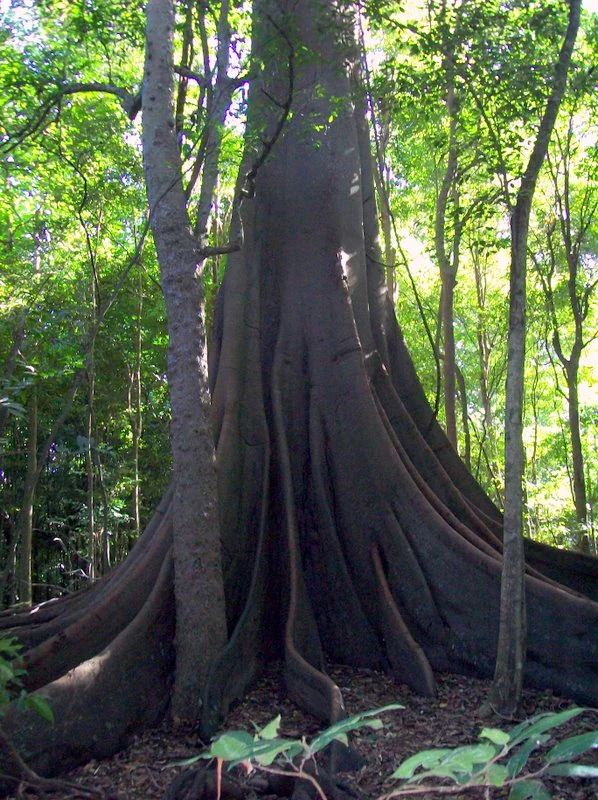
Close-up view of the massive buttress roots of a Moreton Bay fig tree within a dense rainforest.
A giant Moreton Bay fig with prominent buttress roots in the subtropical rainforest of Wingham Brush Nature Reserve.

Wingham Brush Nature Reserve history and protected-area timeline

For the Biripi people, the original custodians of the land on which Wingham Brush now stands, the rainforest known as Wingan, meaning “where bats come to drink,” has been a significant gathering place for thousands of years. They visited the forest regularly to collect plant foods and medicines, harvest fibres for bags and nets, and meet for social and ceremonial purposes, and they continue to regard the rainforest as a place of spiritual importance.

During the period of European settlement and agricultural expansion in the Manning Valley, much of the surrounding lowland rainforest was cleared for farming and town development, leaving only small isolated remnants. Wingham Brush survived largely because of its setting on the river floodplain, but by the second half of the twentieth century the surviving forest had become seriously degraded by invasive species, particularly the vines Madeira vine and cats claw creeper, which choked out native plants and altered the structure of the understorey.

The turning point came in 1980, when local residents began organized volunteer work to remove the weeds and protect regenerating native seedlings. Their systematic approach to restoration gradually transformed the forest back into a functioning rainforest and gave rise to the internationally recognized “Wingham Brush method” of rainforest regeneration. Building on this community achievement, the area was formally gazetted as a nature reserve under the management of the NSW National Parks and Wildlife Service in July 2000, securing long-term protection for one of the few surviving examples of subtropical lowland rainforest in the region.

Wingham Brush Nature Reserve landscape and geographic character

The landscape of Wingham Brush is a small, flat pocket of river-flat rainforest set within a wider valley of cleared pastureland. The reserve occupies alluvial ground on the floodplain of the Manning River, and its soils have been built up over time by sediments carried downstream from the basaltic uplands of the Barrington Tops, the Comboyne Plateau, and the Bulga Plateau.

This setting produces a distinctive lowland rainforest topography rather than dramatic relief. Instead of cliffs or peaks, the eye is drawn upward to the complex vertical structure of the forest itself: a high canopy dominated by enormous Moreton Bay figs, a dense mid-storey of smaller rainforest trees, and a tangled understorey of palms, ferns, vines, and stinging trees. Boardwalks thread through this environment, bringing visitors into close contact with the buttressed trunks, exposed roots, and dripping canopy that define the reserve’s physical character.

Around the reserve, the contrast is sharp. Cleared farmland and the edges of the town of Wingham press close against the forest boundary, making Wingham Brush feel like a green island in an otherwise open landscape. The river itself anchors the setting, providing the moisture and seasonal flooding regime on which the rainforest depends, while the reliable coastal foothills rainfall keeps the forest perpetually green throughout the year.
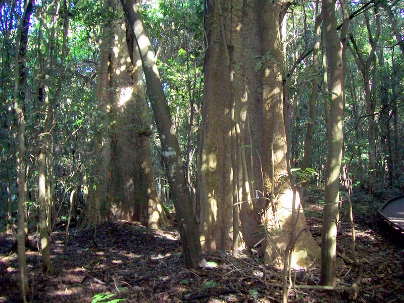
A view of several tall, thick-trunked trees in a dense subtropical rainforest, with dappled sunlight filtering through the canopy onto the forest floor.
Large Dendrocnide excelsa trees growing in the subtropical rainforest at Wingham Brush Nature Reserve.

Wingham Brush Nature Reserve ecosystems, habitats, and plant life

Wingham Brush protects one of the last surviving examples of subtropical lowland rainforest in New South Wales, a vegetation type that has been reduced to scattered fragments across eastern Australia. The reserve’s eight hectares therefore hold a disproportionately rich sample of rainforest biodiversity, with seventy-six recorded tree species layered into a structurally complex forest.

The canopy and mid-storey include emergent Moreton Bay figs, the tallest known blush walnut ever recorded, white cedar, black apple, white walnut, native elm, hairy rosewood, black booyong, and red kamala, alongside the notorious giant stinging tree and its shiny-leaved relative. Palms, tree ferns, and climbing vines fill the spaces between, creating the dense, multi-tiered structure typical of intact lowland rainforest.

Soils and climate underpin this richness. Alluvial sediments enriched by basaltic material upstream support deep root systems, and a mean annual rainfall of around 1,100 millimetres sustains year-round moisture. Active regeneration programs continue to suppress invasive vines that once threatened the forest, with the aim of keeping the site as a near-pristine example of what the broader Manning Valley once looked like before settlement.
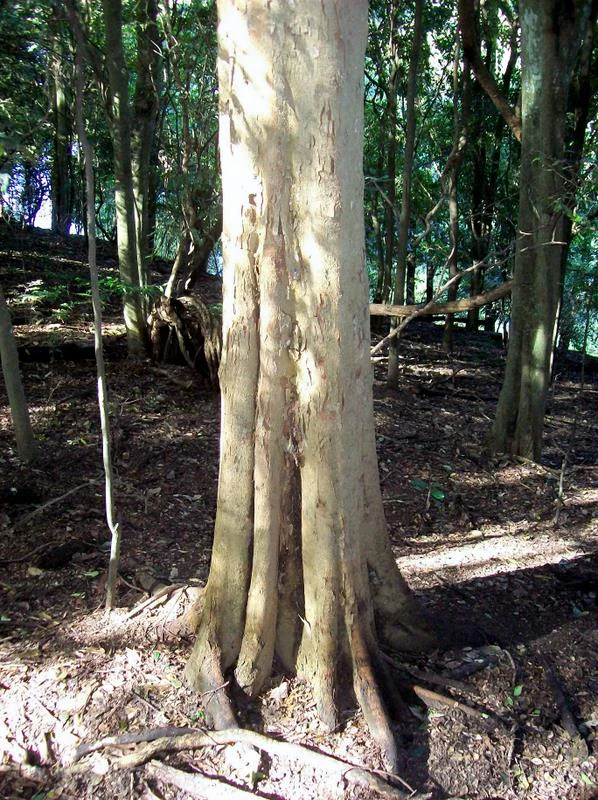
A close-up view of the trunk and flared buttress roots of a large native elm tree in a shaded forest environment.
A native elm tree, Aphananthe philippinensis, growing in the rainforest of Wingham Brush Nature Reserve.

Wingham Brush Nature Reserve wildlife and species highlights

The animal life of Wingham Brush is closely tied to the structure of its rainforest canopy, and the species most associated with the reserve is the grey-headed flying fox. The forest serves as one of the most important communal roosting camps for these large fruit bats on the New South Wales Mid North Coast, and the evening departures of the colony are a defining feature of a visit.

Beyond the flying foxes, the reserve supports a diverse bat community, with several smaller species using the hollows and dense foliage of the canopy. Nocturnal mammals are also well represented, including various gliders and possums that move through the upper layers at night. On the forest floor and in the understorey, large land mullets are a frequently observed reptile, alongside a broader community of skinks and other small reptiles that thrive in the moist leaf litter.

Birdlife is a major draw for naturalists. The reserve hosts ospreys fishing along the nearby Manning River, as well as rainforest specialists such as the green catbird, the wompoo fruit-dove, and the brush turkey, all of which depend on the dense, fruit-bearing canopy. Together, these birds, bats, and reptiles give Wingham Brush an unusually complete picture of lowland rainforest fauna compressed into a very small area.
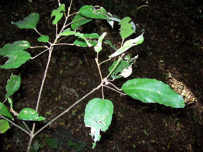
Close-up of green Mallotus philippensis leaves on thin woody stems in a forest setting.
A close-up view of Red Kamala leaves in Wingham Brush Nature Reserve.

Wingham Brush Nature Reserve conservation status and protection priorities

Wingham Brush is a conservation landmark out of proportion to its size. Lowland subtropical rainforest is among the most depleted forest types in eastern Australia, with most original stands cleared for agriculture and urban development, and the reserve preserves one of the few intact remnants of this ecosystem in the Manning Valley. As an IUCN Category IV habitat and species management area, it is formally protected for the long term under the management of the NSW National Parks and Wildlife Service.

The reserve’s broader conservation significance lies in its role as a practical demonstration of community-led rainforest restoration. After decades of degradation caused by invasive vines, coordinated local action from 1980 onward reversed the decline and established the internationally referenced Wingham Brush method. The site is therefore valued not only for what it protects, a rare forest type and the species it shelters, including the vulnerable grey-headed flying fox, but also as a living example of how fragmented ecosystems can be brought back to ecological health.

Ongoing weed monitoring and regeneration programs remain central to the reserve’s management, with efforts focused on keeping invasive species such as Madeira vine and cats claw creeper from re-establishing dominance. The combination of formal protection and continued active management makes Wingham Brush a model for small but ecologically significant reserves across the region.

Wingham Brush Nature Reserve cultural meaning and human context

To the local Biripi people, the rainforest now known as Wingham Brush has long been referred to as Wingan, a word that translates roughly as “where bats come to drink,” a description that captures both the ecological reality and the cultural meaning of the forest. The site was an important destination for Indigenous Australians of the region, who travelled there to gather plant foods, collect medicinal plants, harvest fibres for making bags and nets, and come together for social gatherings.

Beyond its practical uses, the rainforest holds spiritual significance for the Biripi and connects contemporary Indigenous communities to a continuous relationship with the land that long predates the formal protection of the area. The reserve thus sits at the intersection of two conservation stories: the Indigenous stewardship that shaped the forest over millennia, and the more recent community-led effort that rescued it from ecological collapse in the late twentieth century.

Top sights and standout views in Wingham Brush Nature Reserve

Wingham Brush offers an unusually complete rainforest experience compressed into a small, accessible reserve. Visitors come primarily for the chance to stand beneath the massive Moreton Bay figs and observe one of the most important grey-headed flying fox camps on the New South Wales Mid North Coast, with the evening exodus of bats a signature spectacle.

Equally compelling are the seventy-six tree species packed into the eight-hectare site, the chance to see rainforest birds such as the wompoo fruit-dove and green catbird, and the tangible evidence of successful regeneration in a forest that was once choked by invasive weeds. Boardwalks through the understorey, including sections that pass giant stinging trees and the largest known blush walnut, make these highlights easy to experience at close range.

Best time to visit Wingham Brush Nature Reserve

Wingham Brush can be visited year round because the rainforest depends on the region’s consistently moist climate, with annual rainfall averaging around 1,100 millimetres. The forest stays green in all seasons, and the flying fox camp remains active through most of the year, so visitors interested in seeing the bats should generally find them present on any typical day.

The experience differs subtly with the seasons. Warmer months tend to bring more active birdlife and reptiles, while cooler periods can feel quieter underfoot but offer crisper conditions for walking the boardwalks. Avoiding heavy rain periods, when tracks can be slippery, and visiting in the late afternoon, when the flying foxes typically stream out of the canopy, tends to give the most rewarding experience of the reserve’s character.

Monthly climate preview

Long-term temperature ranges and monthly precipitation distributions

Wingham Brush Nature Reserve Climate Normals and Annual Weather Patterns

Representative coordinate measurements reveal measured annual temperature variations and monthly precipitation rhythms across Wingham Brush Nature Reserve. Detailed twelve-month climate profiles provide deeper analytical context for long-term meteorological patterns.
Annual mean19 °C
14 °C24 °C
Jan24°
Feb23°
Mar22°
Apr20°
May17°
Jun15°
Jul14°
Aug14°
Sep17°
Oct19°
Nov21°
Dec22°
Warmest month
January

23.8 °C

Coolest month
July

13.6 °C

Wettest month
February

5.4 mm/day

Driest month
August

1.6 mm/day

Park location guide

Geography guide, regional context, and park location map for Wingham Brush Nature Reserve

Wingham Brush Nature Reserve park geography, regions, and map view in Australia

Understand where Wingham Brush Nature Reserve sits in Australia through a broader geographic reading of the surrounding landscape, nearby location context, and its mapped position within the national park landscape.

How Wingham Brush Nature Reserve fits into Australia

Australia is a constitutional monarchy and federal parliamentary democracy comprising six states and ten territories. With a population of nearly 28 million, it is one of the world's most urbanised countries, with most people concentrated on the eastern seaboard. The country has a high Human Development Index and is known for its cultural diversity, ancient Aboriginal heritage, and unique wildlife.

Wider geography shaping Wingham Brush Nature Reserve in Australia

Australia occupies the entire Australian continent, the island of Tasmania, and numerous smaller islands. It is the world's flattest and driest inhabited continent, featuring vast deserts in the interior (the Outback), tropical rainforests along the eastern coast, and a coastline bordering the Indian and Pacific Oceans.

Map view of Wingham Brush Nature Reserve

Use this park location map to pinpoint Wingham Brush Nature Reserve in Australia, understand its exact geographic position, and read its mapped placement within the surrounding landscape more clearly.

Pigeon | © OpenStreetMap contributors

Location context for Wingham Brush Nature Reserve

New South Wales

Visual reference guide to floodplain topography, towering Moreton Bay figs, and habitat structure

Wingham Brush Nature Reserve Photos, Scenery, and Protected Rainforest Landscapes

Visual documentation captures the complex vertical canopy, buttressed trunk formations, and river-flat topography defining Wingham Brush Nature Reserve. Examining field photography reveals the distinct environmental character of this subtropical lowland rainforest island within New South Wales.

Close-up view of the massive buttress roots of a Moreton Bay fig tree within a dense rainforest.

A wooden boardwalk path curving through a dense subtropical forest with tall trees and leaf litter on the ground.

A view of several tall, thick-trunked trees in a dense subtropical rainforest, with dappled sunlight filtering through the canopy onto the forest floor.

A close-up view of the trunk and flared buttress roots of a large native elm tree in a shaded forest environment.

Close-up of green Mallotus philippensis leaves on thin woody stems in a forest setting.

Park atlas

Compare adjacent lowland rainforest remnants and regional conservation landscapes

Explore Protected Areas and Parks Near Wingham Brush Nature Reserve

Browsing parks near Wingham Brush Nature Reserve reveals connected subtropical ecosystems and river floodplains across the surrounding region. Expanding outward from these alluvial forests offers deeper geographic context for regional conservation terrain and protected landscapes.
A soft watercolor painting of a riverbank scene with trees along a shoreline and rolling hills in the background.
Nature reserveNew South Wales
About 9 km away#1 closest

Southeast

Coocumbac Island Nature Reserve: Mapping Rare Rainforest on the Manning River

Protected island geography in New South Wales

Coocumbac Island Nature Reserve represents a key protected area on the mid-north coast of New South Wales, safeguarding a distinct subtropical lowland rainforest community. The reserve features a dense canopy of strangler figs, mangroves, and alluvial river terrain that serves as a sanctuary for rainforest-dependent wildlife. Its geography provides a clear window into the ecological history of the Manning River and its traditional significance as an Indigenous meeting place.

Area
0.06 km²
Established
1981
IUCN
IV
Water
Water-dominated
National parkNew South Wales
About 20 km away#2 closest

Northeast

Coorabakh National Park: A Protected Volcanic Landscape in New South Wales

Discover unique terrain, mapped protected boundaries, and regional geography.

Coorabakh National Park in New South Wales, Australia, is characterized by its striking volcanic trio: Big Nellie, Flat Nellie, and Little Nellie. These peaks dominate the rugged escarpment terrain, offering a unique geographic vista. The park protects a rich mosaic of tall eucalypt forests and sheltered subtropical rainforest gullies, highlighting its ecological diversity. For those interested in atlas-style exploration, Coorabakh National Park provides a clear example of a protected landscape with significant geological and ecological features within the broader regional context of New South Wales.

Area
18 km²
Established
1999
IUCN
II
Relief
Highland
National parkMid North Coast
About 23 km away#3 closest

Northwest

Tapin Tops National Park: Protected Landscape in Mid North Coast, Australia

Mapped geographic context and natural terrain discovery.

Tapin Tops National Park is a designated national park offering rich opportunities for geographic and landscape exploration. This detail page provides a structured look at its protected area status and its location within the Mid North Coast region of Australia. Delve into the mapped boundaries and understand the park's specific natural terrain for comprehensive atlas-based discovery.

Area
110 km²
Established
1999
IUCN
II
Relief
Mountain
A soft watercolor illustration of a rolling landscape with green trees, a dirt path, and a light-filled background.
Nature reserveNew South Wales
About 24 km away#4 closest

North

Killabakh Nature Reserve: Protected Forest Boundaries and Great Dividing Range Geography

Mapped conservation estate in coastal New South Wales

Killabakh Nature Reserve serves as a significant protected land entity within the New South Wales forest network. This site features rugged escarpment terrain dominated by wet sclerophyll eucalyptus and remnant rainforest. Its preservation contributes to long-term ecological connectivity along the Great Eastern Escarpment, showcasing a distinctive botanical profile rooted in the local landscape and regional environmental history.

Area
26.44 km²
Established
1999
IUCN
Ia
Relief
Mountain
Nature reserveNew South Wales
About 26 km away#5 closest

North

Boorganna Nature Reserve: Protected Rainforest Mapping and Geographic Overview

Essential geographic context on the Comboyne Plateau in New South Wales

Boorganna Nature Reserve preserves a vital corridor of subtropical and warm temperate rainforest within the Comboyne Plateau of New South Wales. By mapping the deep basalt loams and rugged gully terrain, this overview highlights the reserve as a significant historical refuge for diverse forest types and endemic plant species. Analyze the landscape composition, elevation shifts, and the structural integrity of this protected environmental boundary.

Area
4 km²
Established
1904
IUCN
Ia
Relief
Upland
National parkNew South Wales
About 31 km away#6 closest

Northeast

Middle Brother National Park: New South Wales Protected Area and Geographic Exploration

Mapped boundaries and regional landscape context for this national park.

Middle Brother National Park represents a distinct protected landscape within the state of New South Wales, Australia. This entry offers detailed geographic context, focusing on the park's mapped boundaries and its significance as a national park. Users can explore its place within the regional geography of New South Wales, gaining a structured understanding of this protected area through an atlas-focused perspective.

Area
18.3 km²
Established
1999
IUCN
II
Relief
Mountain
National parkNew South Wales
About 33 km away#7 closest

East

Crowdy Bay National Park: New South Wales Protected Coastal Landscape and Terrain Map

Explore mapped boundaries and diverse natural geography within this national park.

Crowdy Bay National Park offers a compelling example of coastal protected landscape in New South Wales, Australia. This page facilitates a detailed atlas exploration of its natural geography, focusing on the interaction between ocean beaches, headlands, and inland forested terrain. Understand the park's specific location and its characteristic ecosystems, providing a structured view of this significant national park for geographic discovery.

Area
102 km²
Established
1972
IUCN
II
Relief
Lowland
National parkNew South Wales
About 34 km away#8 closest

North

Biriwal Bulga National Park: Protected Landscape and Geographic Context within New South Wales

Explore mapped boundaries and the national park's regional setting.

Biriwal Bulga National Park represents a significant protected area within New South Wales, Australia, offering crucial insights into the region's natural landscape geography. This dedicated page details the park's specific identity as a national park, focusing on its mapped geographic boundaries and its contribution to the broader atlas of protected lands. It is designed for users who require structured information about individual protected areas and their precise location and landscape context.

Area
65.28 km²
Established
1999
IUCN
II
Relief
Lowland

Common questions about visiting, size, designation, and location context for Wingham Brush Nature Reserve

Wingham Brush Nature Reserve FAQs for park facts, access, geography, and protected area context

Find quick answers about Wingham Brush Nature Reserve, including protected-area facts, park geography, trail and visitor context, and how the park fits into its surrounding country and regional landscape.
MoriAtlas Explorer

Continue Your Protected Areas Search Across the Global Atlas

Deepen your exploration by continuing the structured search for national parks and protected areas worldwide. Utilize the comprehensive filtering capabilities to compare different conservation landscapes and refine your understanding of global park geography. Discover more about the distribution and characteristics of protected natural areas.

Global natural geography