
Mori Atlas logo
Nature reserveWolbecker Tiergarten

Examining the ecological geography and mapped boundaries of this unique German nature reserve.

Wolbecker Tiergarten: A Protected Lowland Beech Forest and Historic Hunting Park Landscape

The Wolbecker Tiergarten encompasses 288 hectares of protected lowland deciduous woodland on the southeastern edge of Münster, North Rhine-Westphalia. As a formally protected nature reserve and EU Habitats Directive site, it is defined by its ancient beech forest continuity, significant deadwood habitats, and the meandering course of the Angel river. This historic princely hunting park maintains a distinct landscape legacy, featuring centuries-old oaks and a structured grid of forest paths that bridge the intersection of conservation and cultural history.

lowland beech forestnature reserveFFH siteNatura 2000deadwood habitatstate forest
A flat-style digital illustration showing a waterfall flowing over a cliff into a river surrounded by coniferous and deciduous trees.

Wolbecker Tiergarten

Nature reserve

Park overview

Structured park overview, official facts, and landscape profile for Wolbecker Tiergarten

Wolbecker Tiergarten park facts, protected area profile, and essential visitor context

Review the core facts for Wolbecker Tiergarten, including designation, size, terrain, visitor scale, habitats, and operating context in one park-focused overview.

About Wolbecker Tiergarten

The Wolbecker Tiergarten is one of the older and more ecologically significant woodland protected areas in the Münsterland region of North Rhine-Westphalia. It occupies a large portion of the Wolbeck state forest on the southern edge of the city of Münster, where it forms the boundary between the urban area and the surrounding district of Warendorf. Covering close to 288 hectares, it is one of the larger contiguous forest blocks in the broader Münsterland and has retained a notably closed forest character thanks to centuries of protective management under successive land owners.

Ecologically, the reserve is dominated by near-natural deciduous forest, in particular beech communities on pseudogley soils with oak-beech stands in places. The high groundwater table typical of these soils, regulated today by a network of drainage ditches, supports a distinctive damp woodland character that is uncommon in the region. The forest's continuity is unusual: even the large medieval clearances that affected much of the surrounding landscape spared this area thanks to its long use as a protected hunting ground for the Prince-Bishops of Münster, so even today individual trees of two hundred years or more survive, with the Donnereiche reputedly reaching around three hundred years in age.

In administrative terms the Wolbecker Tiergarten is both a German nature reserve (Naturschutzgebiet) and an EU Habitats Directive site, and was designated as such in 2005. Although a small inner reserve had existed since 1911, the wider modern designation reflects recognition of its regional importance for biodiversity, including its deadwood-rich habitat for lichens, mosses, insects, amphibians such as fire salamanders, bats, and cavity-nesting birds. At the same time, the forest remains a quiet recreational landscape, crossed by a regular grid of paths with only a single through road, and crossed in three places by bridges over the Angel.

Quick facts and research context for Wolbecker Tiergarten

The Wolbecker Tiergarten is a combined nature reserve and European Habitats Directive site located within the Wolbeck state forest in the southeast of Münster, North Rhine-Westphalia. The protected area covers roughly 288 hectares of contiguous deciduous woodland split by the Angel river into a smaller northern part called the Kellingholz and a larger southern part. The reserve lies at the boundary between the city of Münster and the district of Warendorf and is surrounded by earth banks dating to its eighteenth-century redesign.

Ecologically, it is dominated by beech forests on pseudogley soils, with oak-beech communities in some stands, and is notable for its abundance of dead wood and old trees, including individual specimens of extreme age. Although a small reserve already existed within it in 1911, the entire current area was only formally protected in 2005 and simultaneously designated as part of the European Union's Natura 2000 network.

Protection and recognition

Examine the documented terrestrial protection scope and official designation records for Wolbecker Tiergarten.

Wolbecker Tiergarten Protection Status and Natura 2000 Recognition Details

Terrestrial protection status records for Wolbecker Tiergarten detail official conservation frameworks and registered boundaries. Natura 2000 recognition data outlines the verified designation sources linked to this protected natural area.

International recognition

Protection details

Protection scope
Terrestrial
Transboundary protection
No
Park context

Deeper park guide and search-rich context for Wolbecker Tiergarten

Wolbecker Tiergarten history, landscape, wildlife, and travel context

Explore Wolbecker Tiergarten through its history, landscape character, ecosystems, wildlife, conservation priorities, cultural context, and seasonal travel timing in a structured park guide built for atlas discovery and search intent.

Why Wolbecker Tiergarten stands out

The Wolbecker Tiergarten is best known for being a sizeable, ecologically rich lowland beech forest reserve with strong woodland continuity in an otherwise heavily altered landscape. Its value comes from the combination of near-natural deciduous forest on wet, pseudogley soils, an exceptionally high density of deadwood, and the presence of very old individual trees such as the Donnereiche. The reserve is also recognized for its rich habitat mosaic for lichens, mosses, saproxylic insects, amphibians including a notably isolated fire salamander population, bats, and cavity-nesting birds such as the middle spotted woodpecker and the honey buzzard, all set within a forest that was historically used as a princely hunting park.
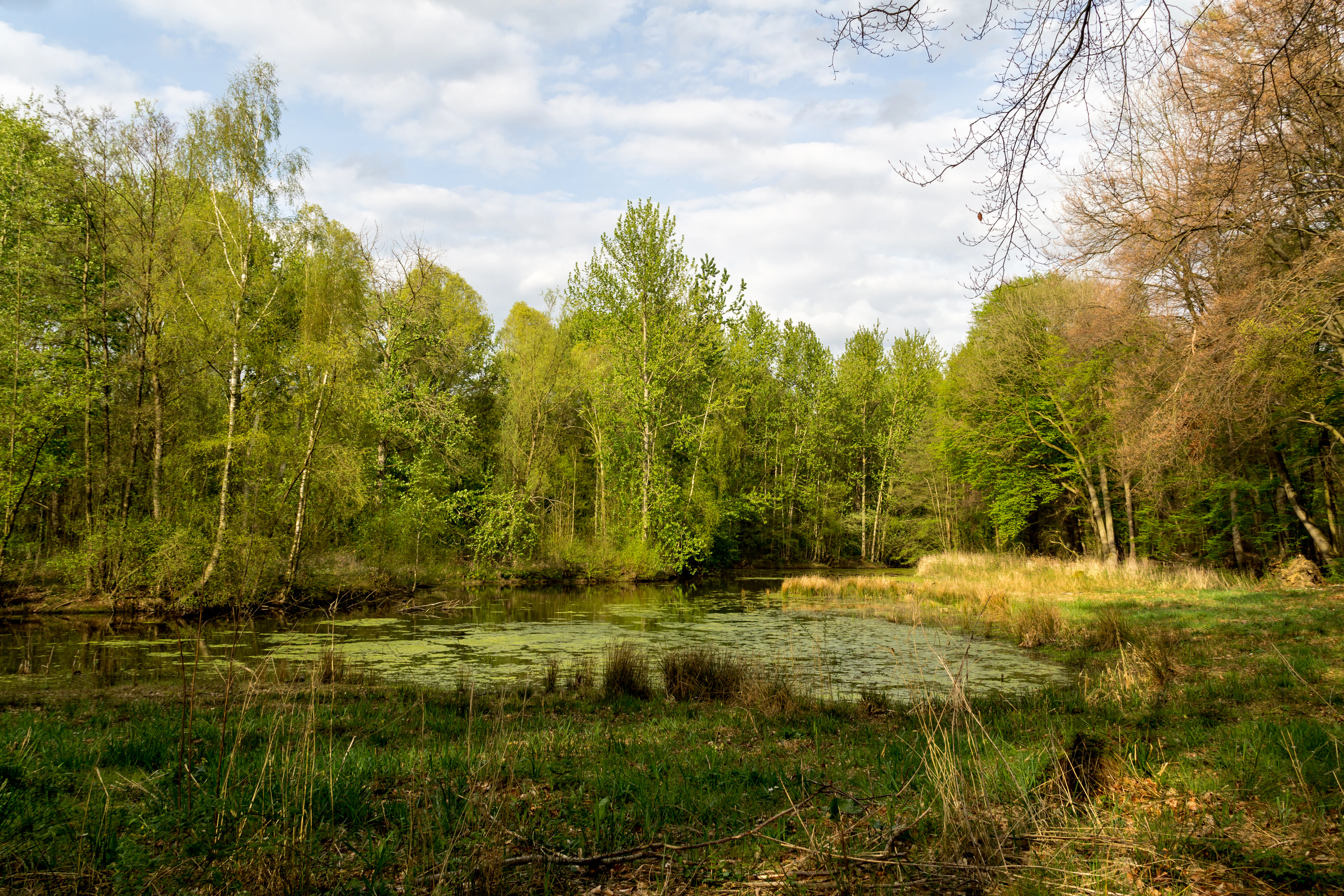
A small pond covered with light green vegetation surrounded by dense deciduous trees under a cloudy sky.
A tranquil pond surrounded by lush deciduous forest in the Wolbecker Tiergarten.

Wolbecker Tiergarten history and protected-area timeline

The Wolbecker Tiergarten is one of the oldest forests in the Münsterland, with its origins in a wooded mark first laid out in the twelfth century. For most of its early history it formed part of a broader forested landscape, but from the late seventeenth century onward it was increasingly used by the Prince-Bishops of Münster as a hunting park. The decisive moment came around 1740 under Prince-Bishop Clemens August I of Bavaria, who gave the forest its present grid-like layout and bordered it with the characteristic earthen banks that still mark its edges today. A boundary stone from 1740, bearing the initials C.A. and a princely electoral hat, still stands opposite the older forester's house, which itself was built back in 1712.

Around 1770 the Wolbecker Tiergarten became the sole hunting ground of the Prince-Bishops of Münster after the adjoining Sassenberg forest was abandoned. The forest was used not only for hunting but also for princely recreation, but this era ended abruptly with secularization in 1803, when the area passed into Prussian hands. Under Prussian administration, and despite a brief French occupation, General Gebhard Leberecht von Blücher oversaw the shooting of the last of the park's game, and the forest was turned over to timber production.

In the late nineteenth century the forest gradually took on a new public role, becoming a place for recreation among citizens of Münster and eventually hosting a small inn in the forester's house that proved very popular but closed around 1914. In the 1920s a new café operated at the nearby Hof Markfort until 1943, and in the 1930s there were plans, ultimately abandoned, to establish a bathing facility along the meadows of the Angel. In the postwar period the area was managed as the Münster state forest, and a last major channel-straightening of the Angel within the forest took place in 1980, partly compensated by the creation of an oxbow used as a biotope and winter ice-skating area. While a small inner nature reserve had existed since 1911, only in 2005 was the entire current 287-hectare area declared a nature reserve and simultaneously notified as a European Union Habitats Directive site.

Wolbecker Tiergarten landscape and geographic character

The Wolbecker Tiergarten is a lowland deciduous forest landscape set within the broader Münsterland, characterized by flat to gently undulating terrain underlain by seasonally waterlogged pseudogley soils. The forest is cut roughly in two by the Angel river, which flows east to west through the area and divides the reserve into a smaller northern section known as the Kellingholz and a larger southern section. Three bridges cross the Angel within the reserve, while elsewhere the paths are typical forest tracks, with only a single road, the Tiergarten, asphalted and continued as a gravel track beyond.

The visual character of the landscape is shaped strongly by its eighteenth-century design as a hunting park. A regular grid of broad paths runs through the woodland, and the edges of the forest are still defined by low earthen banks built when the park was laid out. Individual very old trees, including the famous Donnereiche with its four-and-a-half-meter trunk circumference, and scattered noble stand trees give the forest a distinctive mature, slightly park-like feel beneath the otherwise dense deciduous canopy. Remnants of historical infrastructure, such as the baroque 1740 boundary stone with the initials of Prince-Bishop Clemens August, and old signage at Hof Markfort, remain visible features in the cultural landscape.
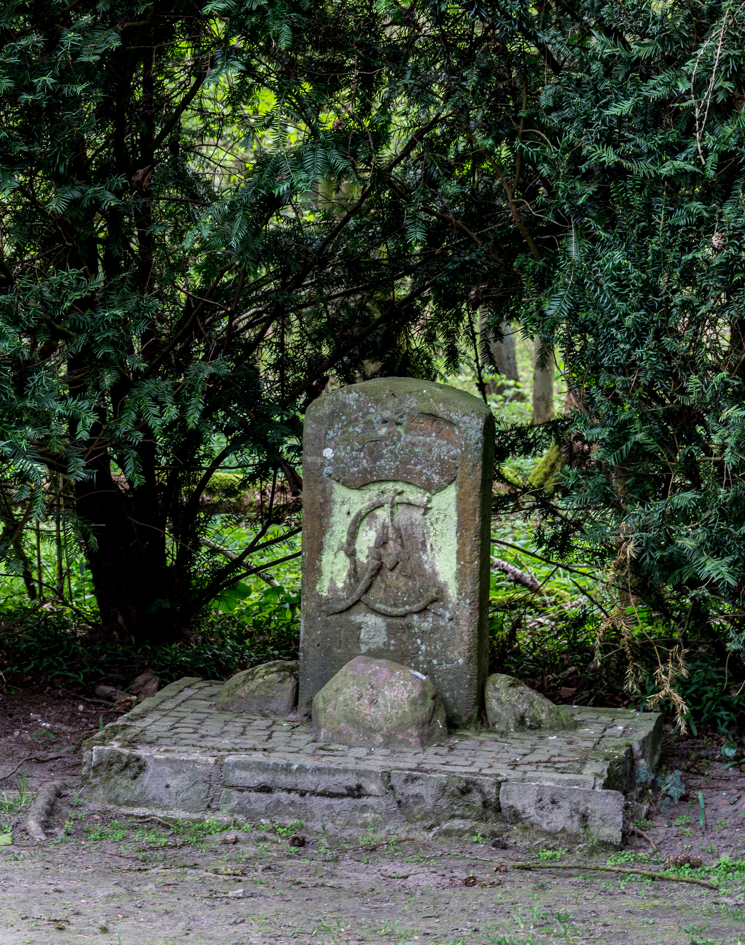
A weathered stone monument stands on a small paved stone platform in a wooded area, featuring an carved crest and initials.
A historic 1740 Baroque boundary stone featuring the initials of Prince-Bishop Clemens August, situated within the Wolbecker Tiergarten forest.

Wolbecker Tiergarten ecosystems, habitats, and plant life

Ecologically, the Wolbecker Tiergarten represents a regionally important example of near-natural lowland deciduous forest, in particular of beech woodland on pseudogley soils. The dominant forest type is the woodrush-beech forest, with oak-beech communities in places, much of which developed through historical forestry favoring beech. Because the soils are seasonally waterlogged and the forest stands on a high groundwater table, the woodland has a distinctly moist character that supports a particular suite of plant communities and makes the beech trees particularly vulnerable to storm damage.

The forest is managed today with attention to natural processes, including designated natural forest cells (Naturwaldzellen) such as the Teppes Viertel, where deadwood is allowed to accumulate. This abundance of deadwood is one of the key ecological features of the area, supporting rich populations of lichens, mosses, and saproxylic, or deadwood-dependent, insects. A network of drainage ditches still modulates the groundwater within the reserve, and the river Angel, with the oxbow biotope created after its 1980 straightening, adds an additional aquatic and wetland habitat component to the broader forest mosaic. The overall ecological value of the reserve derives largely from its long continuity as forest and from its unusually closed landscape character compared with much of the surrounding Münsterland.
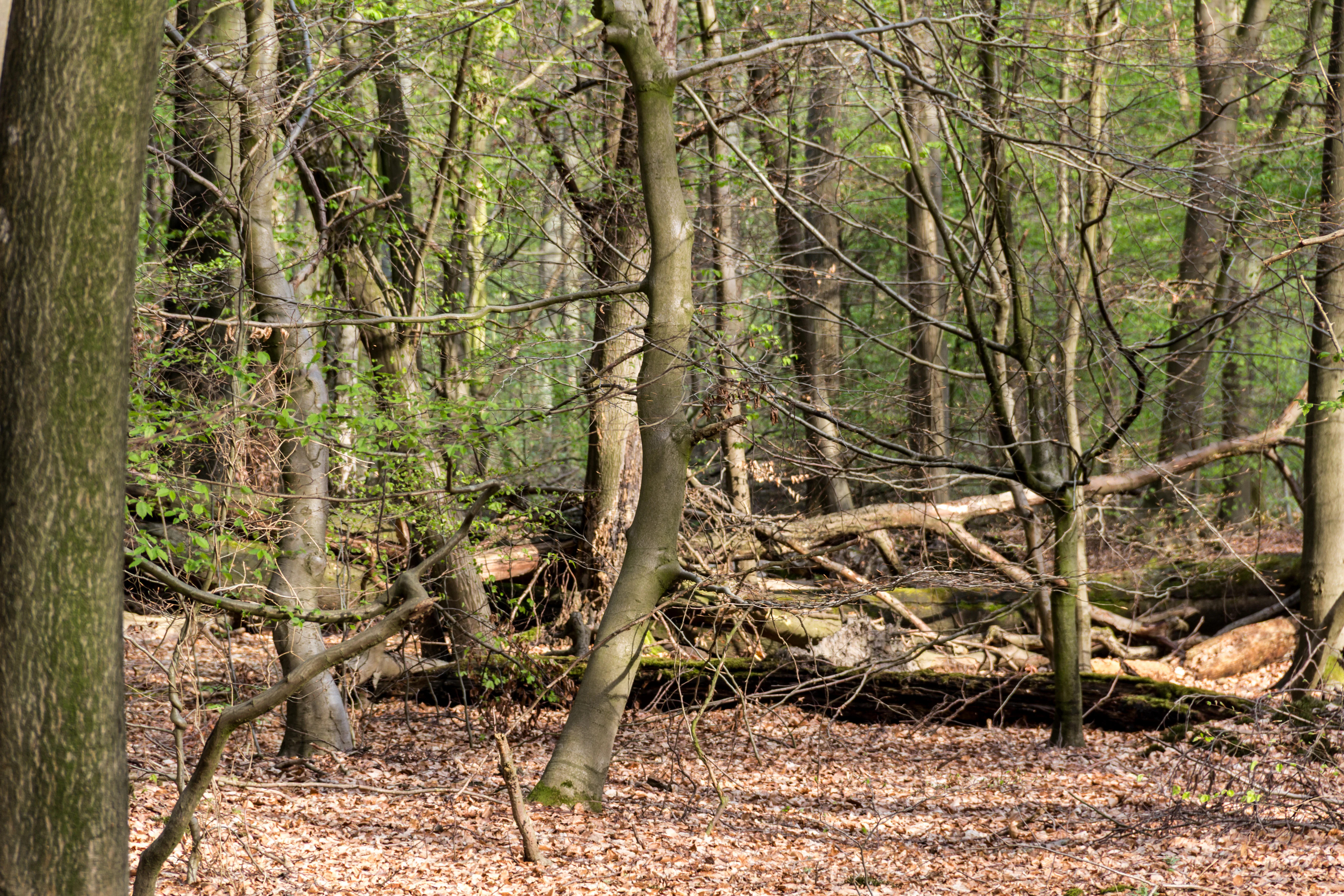
A section of a deciduous forest in spring, featuring thin tree trunks, fallen logs on the leaf-covered ground, and new green leaves sprouting on branches.
A view into the Teppes Viertel natural forest reserve within Wolbecker Tiergarten, showing mature trees and natural woodland debris.

Wolbecker Tiergarten wildlife and species highlights

The wildlife interest of the Wolbecker Tiergarten has been documented since the nineteenth century and is one of the main reasons the area is protected today. The deadwood-rich forest provides particularly favorable conditions for lichens, mosses, and a wide range of insects, which in turn underpin richer vertebrate communities.

Among vertebrates, amphibians are especially notable: the reserve hosts an isolated population of fire salamanders, whose nearest neighbors live around 20 kilometers away, making the Wolbecker Tiergarten population particularly important for the regional conservation of the species. Bats and cavity-nesting birds, especially the middle spotted woodpecker, are likewise well represented, and the area is one of the places where the regionally uncommon honey buzzard is regularly recorded. The combination of old trees, high deadwood volumes, wet forest soils, and the Angel river corridor gives the reserve a habitat mosaic that supports this unusually broad range of species groups for an urban-proximate woodland.
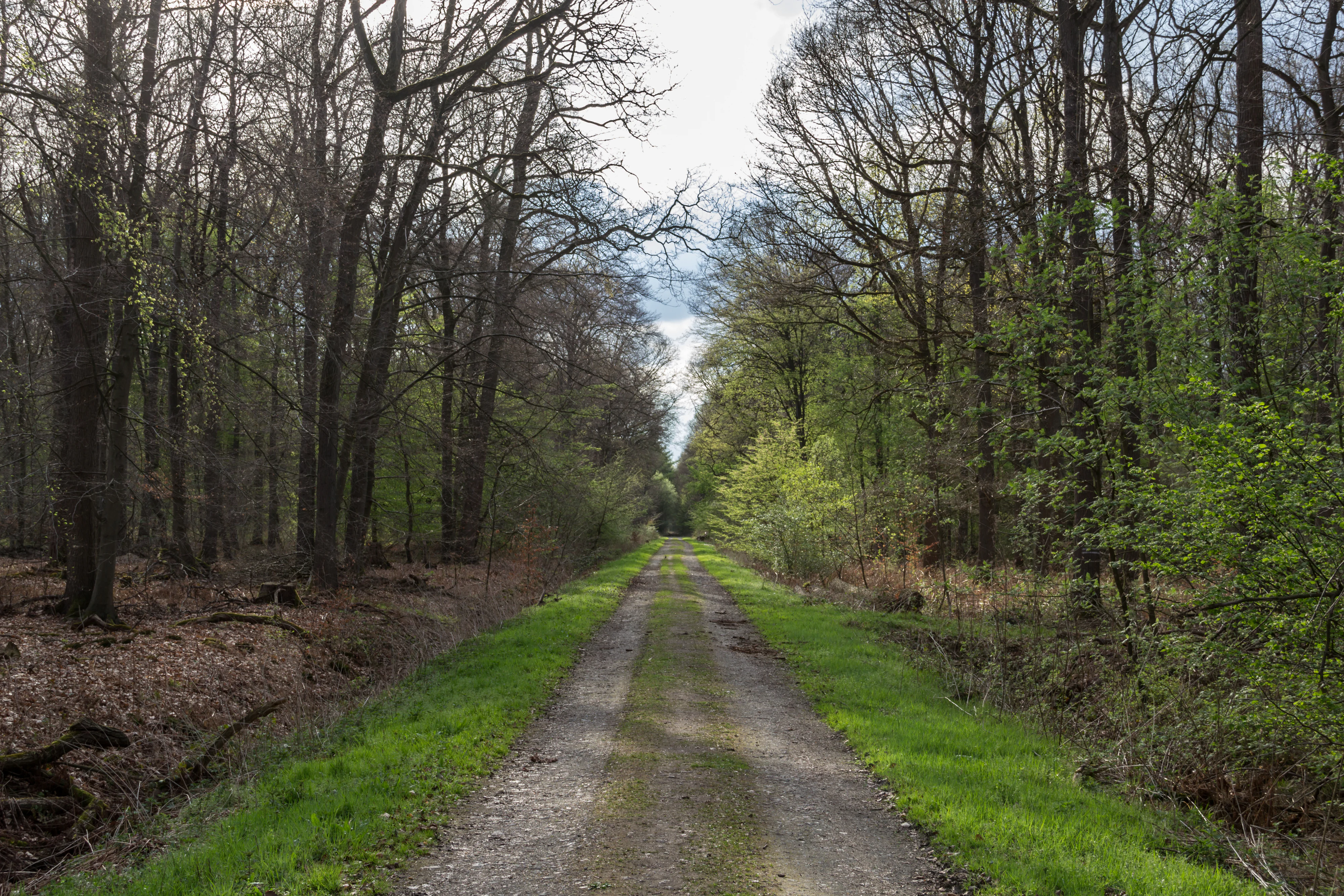
A straight dirt path stretches into the distance, flanked by dense forest with deciduous trees in early spring leaf development.
A dirt path leads through the dense, mature woodland of Wolbecker Tiergarten.

Wolbecker Tiergarten conservation status and protection priorities

From a conservation perspective, the Wolbecker Tiergarten is significant mainly because of its size, its landscape coherence, and its long continuity as woodland in a region that otherwise lost much of its forest to medieval clearance and later exploitation. Protected formally as a nature reserve in 2005 and simultaneously designated as a European Habitats Directive (FFH) site, it now forms part of the Natura 2000 network and represents one of the more ecologically valuable lowland beech forest areas in the Münsterland.

Its conservation importance rests on several reinforcing factors. The forest has survived as forested land since at least the twelfth century and, because it was used for centuries as a princely hunting park and later as state forest, was spared the most destructive phases of clearance. The resulting near-natural deciduous forest, especially beech forest on pseudogley soils, provides a regionally scarce habitat type. The high deadwood volumes, the natural forest cells including the Teppes Viertel, and the presence of old individual trees of two to three hundred years of age further raise its value for specialist species such as lichens, mosses, saproxylic insects, fire salamanders, bats, and cavity-nesting birds. Together these features make the Wolbecker Tiergarten a key reference site for the protection of near-natural, deadwood-rich lowland beech forest in northwestern Germany.

Wolbecker Tiergarten cultural meaning and human context

The Wolbecker Tiergarten carries a strong cultural identity tied to its long history as a noble hunting park of the Prince-Bishops of Münster and, before that, as a medieval wood-mark. The forest still bears the physical marks of its eighteenth-century redesign under Prince-Bishop Clemens August I of Bavaria in the form of the regular path grid and the surrounding earthen banks, as well as a baroque boundary stone dated 1740 that is carved with the initials C.A. and the electoral hat of the prince-bishop.

The area was also closely interwoven with everyday city life: from the late nineteenth century onward it served as a leisure forest for the citizens of Münster, hosting a popular inn in the historic forester's house, a later café at the nearby Hof Markfort, and ambitious but unrealized plans in the 1930s for a bathing establishment along the Angel meadows. The site is recognized regionally as a culturally significant landscape element, documented in landscape surveys of Westphalia-Lippe as a regionally important cultural landscape area, reflecting its joint ecological and historical importance for the region.

Top sights and standout views in Wolbecker Tiergarten

The Wolbecker Tiergarten stands out as a sizeable, ecologically coherent lowland beech forest reserve with centuries of woodland continuity, an exceptionally high deadwood component, and individual trees of extraordinary age such as the Donnereiche. Its combination of nature reserve and EU Habitats Directive status underscores its value for regional conservation, while the presence of an isolated fire salamander population strengthens its significance for species protection in the Münsterland.

Equally distinctive is the legible imprint of its eighteenth-century use as a princely hunting park under the Prince-Bishops of Münster, visible in the grid of broad forest roads, the enclosing earthen banks, the 1740 boundary stone, and the historic forester's house. Together with the Angel river, its oxbow biotope, and the network of forest paths, these cultural and natural elements give the reserve a clear identity as a place where old forest character, princely landscape design, and modern nature conservation all intersect.

Best time to visit Wolbecker Tiergarten

As a quiet deciduous woodland within and just outside Münster, the Wolbecker Tiergarten can be visited comfortably in any season, but its character shifts noticeably through the year. In spring and early summer the beech canopy is fully leafed and the wet forest soils and the Angel river are at their most lush, which is also the most active period for amphibians and for breeding birds, including cavity-nesting species.

Autumn brings the most visually striking forest character, when the beech trees turn color and the abundance of deadwood and old trees is most atmospheric under low light, while the cooler weather also makes long walks along the regular grid of paths and the bridges over the Angel particularly pleasant. Winter can be quieter and colder, with frost and occasional hoarfrost on the old trees, and the Angel oxbow has historically been used as an informal ice-skating surface after long cold spells; visitors should expect wet, possibly flooded sections of the path network at this time of year given the reserve's high groundwater table.

Monthly climate preview

Long-term representative coordinate measurements detailing monthly temperature and precipitation averages.

Wolbecker Tiergarten Climate Normals, Annual Temperature and Precipitation Rhythm

Representative coordinate data records long-term monthly temperature and precipitation values to map the annual climate rhythm across Wolbecker Tiergarten. Detailed twelve-month climate normals provide complete statistical context for average temperature and precipitation distributions.
Annual mean10 °C
1 °C19 °C
Jan
Feb
Mar
Apr
May13°
Jun16°
Jul19°
Aug18°
Sep15°
Oct10°
Nov
Dec
Warmest month
July

18.6 °C

Coolest month
January

1.3 °C

Wettest month
December

2.5 mm/day

Driest month
April

1.5 mm/day

Park location guide

Geography guide, regional context, and park location map for Wolbecker Tiergarten

Wolbecker Tiergarten park geography, regions, and map view in Germany

Understand where Wolbecker Tiergarten sits in Germany through a broader geographic reading of the surrounding landscape, nearby location context, and its mapped position within the national park landscape.

How Wolbecker Tiergarten fits into Germany

Germany is a federal republic in Western and Central Europe with a population of over 83 million across sixteen constituent states. It is Europe's largest economy by nominal GDP and a major global exporter and importer. The capital is Berlin, and the country borders Denmark, Poland, Czech Republic, Austria, Switzerland, France, Luxembourg, Belgium, and the Netherlands.

Wider geography shaping Wolbecker Tiergarten in Germany

Germany is located in Western and Central Europe, spanning 357,022 km². It borders Denmark to the north, Poland and the Czech Republic to the east, Austria and Switzerland to the south, and France, Luxembourg, Belgium, and the Netherlands to the west. The country has coastlines on the Baltic Sea and North Sea to the north, with the Alps located in the southern region.

Map view of Wolbecker Tiergarten

Use this park location map to pinpoint Wolbecker Tiergarten in Germany, understand its exact geographic position, and read its mapped placement within the surrounding landscape more clearly.

Pigeon | © OpenStreetMap contributors

Location context for Wolbecker Tiergarten

North Rhine-Westphalia
Recorded earthquake history

Browse the Historical Earthquake Catalogue for Wolbecker Tiergarten

Consult the dedicated collection of recorded seismic events associated with the geography of Wolbecker Tiergarten. This MoriAtlas resource provides a transparent, data-driven view of historical records including event timing, magnitude, and distance for those studying the regional seismicity of this protected forest.

Wolbecker Tiergarten Earthquake History

Catalogued events

39 events

Strongest magnitude

Magnitude 4.7

Most recent event

Dec 20, 2008

This history includes earthquakes recorded inside the park or within 50 km of its borders

Protected area views, lowland beech forest habitats, and terrain character

Wolbecker Tiergarten Photos and Landscape Scenery Visual Exploration

Visual documentation reveals the ancient deciduous canopy, deadwood habitats, and flat wetland terrain defining the protected reserve. Detailed photography illustrates the mature tree specimens and historic boundary features shaping the regional ecosystem.

A small pond covered with light green vegetation surrounded by dense deciduous trees under a cloudy sky.

A calm, narrow river flowing through a lush green deciduous forest with a dirt trail running along its bank.

A weathered stone monument stands on a small paved stone platform in a wooded area, featuring an carved crest and initials.

A section of a deciduous forest in spring, featuring thin tree trunks, fallen logs on the leaf-covered ground, and new green leaves sprouting on branches.

A straight dirt path stretches into the distance, flanked by dense forest with deciduous trees in early spring leaf development.

Park atlas

Compare adjacent forest reserves and regional woodland habitats

Parks Near Wolbecker Tiergarten and Surrounding Protected Landscapes

Visitors exploring Wolbecker Tiergarten can browse other nearby nature reserves and protected lowland forests across the region. Reviewing adjacent conservation areas helps place individual woodland habitats into a broader geographical perspective.
A pale, soft watercolor illustration showing rolling hills, sparse trees, and gentle inland dune slopes under a light sky.
Protected landscapeBerlin
21 km away#1 closest

East

Baumberge Protected Landscape: Mapping Berlin's Glacial Sand Dunes and Rare Grassland Habitats

A vital protected ecosystem within the Tegeler Forst region

The Baumberge stand as one of the last remaining open inland dune sites in Berlin, encompassing a fragile 47 hectare mosaic of sand heath and dry grassland. These parabolic dunes provide a critical refuge for warmth-loving invertebrate species and rare flora, anchored by glacial sand deposits dating back to the last ice age. The area offers a significant window into the historical landscape evolution of the northern Berlin glacial valley.

Area
0.47 km²
Relief
Lowland
Climate
Temperate
Access
Easy access
Nature reserveLandkreis Osnabrück
About 21 km away#2 closest

Northeast

Sudendorfer Vennepohl Nature Reserve: Geography and Protected Wetland Atlas

A significant peatland site in Landkreis Osnabrück, Germany.

Explore the geographic identity of Sudendorfer Vennepohl, a protected lowland mire situated in the Osnabrück plain. This site is defined by its sandy substrate, pine forest surroundings, and rare bog flora that thrives in nutrient-poor, acidic conditions. Understanding its origins as an ancient river oxbow provides essential context for the ongoing conservation of this unique wetland relict.

Area
0.204 km²
Established
1951
IUCN
IV
A watercolor illustration of a rolling grassy landscape with a cluster of pine and deciduous trees on a white background.
Protected areaGermany
About 23 km away#3 closest

North

Hüttruper Heide Protected Area: Münsterland Heathland Geography and Maps

A compact and scientifically significant nature reserve in North Rhine-Westphalia.

Hüttruper Heide serves as a concentrated example of historic Westfalian heathland. The area features a distinct geological contrast between dry heath ridges and moist, molinia-filled depressions. It remains a key case study in landscape conservation, highlighting the ongoing tension between industrial infrastructure expansion and the survival of rare, fragmented plant habitats.

Area
0.123 km²
Established
1938
Relief
Lowland
Climate
Temperate
A minimalist watercolor painting showing a winding river through a soft green and yellow landscape with distant rolling hills.
Nature reserveKreis Warendorf
About 24 km away#4 closest

Southeast

Lippeaue zwischen Schloss Oberwerries und Dolberg Protected Riverine Landscape Atlas

Nature reserve geography and riparian floodplain terrain

Located in Kreis Warendorf, Lippeaue zwischen Schloss Oberwerries und Dolberg is a distinctive nature reserve shaped by the Lippe River. The area features a concentration of still waters, reed beds, and meandering channels that showcase the natural dynamics of a lowland floodplain. This protected territory provides a detailed look at the interface between riverine ecosystems and regional landscape preservation in Germany.

Area
0.31 km²
Established
1993
IUCN
IV
Relief
Lowland
Nature reserveNorth Rhine-Westphalia
About 29 km away#5 closest

North

In den Hiärken Nature Reserve: Mapped Protected Area and Wetland Geography in Steinfurt

A fragmented mosaic of wet meadow habitats in North Rhine-Westphalia

Located in the Münsterland region, In den Hiärken consists of six separate parcels that form a vital wet-habitat network. The landscape is defined by its low-lying, undulating terrain and moisture-rich soils, standing in stark contrast to the surrounding agricultural fields and major infrastructure routes such as the A 1 motorway and Dortmund-Ems Canal.

Area
1.664 km²
Established
1992
Nature reserveNordrhein-Westfalen
About 33 km away#6 closest

Southeast

Märzenbecherwald Nature Reserve: Wetland Mosaic and Protected Forest in Nordrhein-Westfalen

A rare calcareous fen and alder swamp forest ecosystem

This protected nature reserve in the Warendorf district serves as a vital ecological anchor, preserving a mosaic of spring-fed seeps, damp woodlands, and calcareous fens. Despite its modest size, the area provides a sharp contrast to the surrounding agricultural fields of the Münsterland region, maintaining a essential water-logged habitat for specialized plant species.

Area
0.016 km²
Established
1995
IUCN
IV
Relief
Lowland
A soft watercolor illustration showing a calm, light-toned landscape with a river, a fallen tree reaching into the water, and sparse trees against a backdrop of gentle hills.
Nature reserveNordrhein-Westfalen
About 35 km away#7 closest

Southeast

Lippeaue zwischen Hamm und Lippstadt mit Ahsewiesen Protected Area and Wetland Geography

Mapping the floodplain meadows and river restoration in Nordrhein-Westfalen

Investigate the complex landscape structure of this prominent nature reserve, defined by its extensive floodplain meadows, reed beds, and remnants of alluvial forest. The site offers a clear look at how restored river meanders and managed grassland complexes function within the wider lowland geography of Germany.

Area
72 km²
Established
2004
Relief
Lowland
Climate
Temperate
Watercolor painting of a green and pink moor landscape with a distant tree line.
Nature reserveNordrhein-Westfalen
About 38 km away#8 closest

East

Hühnermoor Nature Reserve: Geographic Analysis of a Protected Peatland in Nordrhein-Westfalen

A preserved raised-bog landscape and historic botanical refuge

Hühnermoor represents a rare, compact peatland ecosystem situated between ancient sand dunes in the Münsterland region. This nature reserve functions as a critical protected landscape, offering deep insights into regional vegetation history through its stratified peat layers while supporting threatened specialist wetland species.

Area
0.085 km²
Established
1938
IUCN
IV
Relief
Lowland

Common questions about visiting, size, designation, and location context for Wolbecker Tiergarten

Wolbecker Tiergarten FAQs for park facts, access, geography, and protected area context

Find quick answers about Wolbecker Tiergarten, including protected-area facts, park geography, trail and visitor context, and how the park fits into its surrounding country and regional landscape.
MoriAtlas Explorer

Continue Your Protected Areas Search Across the Global Atlas

Deepen your exploration by continuing the structured search for national parks and protected areas worldwide. Utilize the comprehensive filtering capabilities to compare different conservation landscapes and refine your understanding of global park geography. Discover more about the distribution and characteristics of protected natural areas.

Global natural geography