Mori Atlas logo
National parkYarkon-Tel Afek National Park

Discover the mapped landscape and protected boundaries of this national park.

Yarkon-Tel Afek National Park: Protected Area Details and Geographic Context in Israel

Yarkon-Tel Afek National Park stands as a protected national park entity within Israel, offering insights into its distinct geographic setting and natural landscape. This page provides a foundational understanding of the park's mapped boundaries and its place in the regional atlas, crucial for appreciating its protected-area status and ecological context. Explore the specific geography that defines Yarkon-Tel Afek National Park.

Archaeological ParkHistorical SiteOttoman FortressAncient CityYarkon RiverStrategic Location

Yarkon-Tel Afek National Park

National park

Park overview

Structured park overview, official facts, and landscape profile for Yarkon-Tel Afek National Park

Yarkon-Tel Afek National Park park facts, protected area profile, and essential visitor context

Review the core facts for Yarkon-Tel Afek National Park, including designation, size, terrain, visitor scale, habitats, and operating context in one park-focused overview.

About Yarkon-Tel Afek National Park

Yarkon-Tel Afek National Park preserves a remarkable concentration of historical and archaeological significance at the point where the Yarkon River emerges from the earth in central Israel. The park's territory encompasses the tel (ancient mound) of Tel Afek, the ruins of the ancient city of Antipatris founded by Herod the Great, the Ottoman fortress of Ras al-Ayn, and the remains of a British Mandate-period water pumping station that once channeled water to Jerusalem. The location's strategic importance derives from its position at the confluence of the Yarkon springs, which created a natural obstacle separating the hill country to the east from the Mediterranean coastal plain to the west. Travelers and armies throughout history were forced to pass through the narrow Afek Pass, making control of this location a matter of considerable military and economic significance. The park today allows visitors to walk through layers of history, from Bronze Age defensive walls and palace complexes through Hellenistic and Roman urban remains to medieval and early modern fortifications. The Yarkon River, whose Arabic name Nahr Abu Fitrus preserves the ancient Antipatris toponym, continues to flow through the park, supporting riparian vegetation and creating a distinctive ecological corridor in the otherwise densely populated central Israeli landscape.

Quick facts and research context for Yarkon-Tel Afek National Park

Yarkon-Tel Afek National Park is located in Israel's Central District, protecting the ancient site of Antipatris at the headwaters of the Yarkon River. The park encompasses remains from multiple historical periods including Bronze Age palaces, a Roman city, a 16th-century Ottoman fortress, and British Mandate infrastructure. The location controlled the ancient Via Maris trade route and later served as a strategic point on the Cairo-Damascus highway. Archaeological excavations have uncovered significant finds including one of the oldest winepresses in the Southern Levant, dating to the reign of Ramesses II, as well as evidence of trade connections with Cyprus and Mycenaean Greece. The park is managed by the Israel Nature and Parks Authority.

Protection and recognition

Documenting terrestrial boundaries and official conservation management frameworks.

Yarkon-Tel Afek National Park Protection Status and Designation Details

Standardized records outline the terrestrial protection status and established conservation boundaries of Yarkon-Tel Afek National Park. Regional geographic insights provide structured context regarding international designations and documented management history for comparative atlas research.

Protection details

Protection scope
Terrestrial
Park context

Deeper park guide and search-rich context for Yarkon-Tel Afek National Park

Yarkon-Tel Afek National Park history, landscape, wildlife, and travel context

Explore Yarkon-Tel Afek National Park through its history, landscape character, ecosystems, wildlife, conservation priorities, cultural context, and seasonal travel timing in a structured park guide built for atlas discovery and search intent.

Why Yarkon-Tel Afek National Park stands out

Yarkon-Tel Afek National Park is best known for its exceptional archaeological stratification, preserving remains from ancient Aphek through the Hellenistic, Roman, Byzantine, Crusader, and Ottoman periods at a single location. The park protects the remarkably well-preserved 16th-century Ottoman fortress known as Binar Bashi or Ras al-Ayn, built to guard the strategic springs and highway. The site is also renowned for its identification with biblical Aphek, mentioned in the story of the Battle of Aphek and the Philistine capture of the Ark of the Covenant. The Yarkon River springs themselves represent a significant hydrological feature that has shaped both human history and the ecological character of the area, creating a verdant oasis amid the central Israeli landscape.

Yarkon-Tel Afek National Park history and protected-area timeline

The history of Yarkon-Tel Afek spans over three millennia of continuous human occupation. The site was already significant in the Bronze Age, when defensive walls and a series of palaces were constructed, including an Egyptian governor's residence from the 15th century BCE containing cuneiform tablets. Scholars identify this location as either the tower of Aphek mentioned by Josephus or the biblical Aphek famous from the account of the Philistines' capture of the Ark. In the first century BCE, Herod the Great built the city of Antipatris on the site, naming it in honor of his father Antipater. The city was situated on the major Roman road connecting Caesarea Maritima to Jerusalem and played a prominent role in Roman-era history, notably during the Jewish war of 66 CE when Roman forces were routed as far as Antipatris. The biblical apostle Paul was brought here by night from Jerusalem before being taken to Caesarea for trial. The city suffered severe damage in an earthquake in 363 CE and later declined. During the Crusader period, the site was known as Surdi fontes (Silent springs). The Ottoman fortress known as Binar Bashi was constructed in 1573 to protect the Cairo-Damascus highway, and during the British Mandate a water pumping station was built to supply Jerusalem. The Arab population deserted the village in the 1920s, and the site was subsequently incorporated into the national park system.

Yarkon-Tel Afek National Park landscape and geographic character

The landscape of Yarkon-Tel Afek National Park is defined by the Yarkon River springs, which emerge from the ground at the park's heart, creating a distinctive wetlands environment amid the densely populated central Israeli plain. The terrain is relatively flat, lying at the transition between the Sharon plain to the north and the more undulating terrain approaching the foothills of Samaria to the east. The Ottoman fortress, a massive rectangular enclosure with four corner towers and a central gate, dominates the landscape with its stone walls rising above the surrounding terrain. The ancient tel rises slightly above the surrounding area, preserving the mound of accumulated archaeological deposits across millennia. The river corridor supports riparian vegetation including tamarisk, oleander, and various reeds, creating a green belt through the landscape. The combination of water, built structures, and ancient earthworks creates a park landscape of considerable visual and historical interest, where the physical remnants of different historical periods are visible in a relatively compact area.

Yarkon-Tel Afek National Park ecosystems, habitats, and plant life

The ecological character of Yarkon-Tel Afek is shaped by the presence of the Yarkon River springs, which create a freshwater habitat in an area where such aquatic environments are relatively rare. The springs support a riparian ecosystem with characteristic vegetation adapted to permanent water presence, including willows, tamarisks, and various wetland plants. The river corridor serves as a green pathway through the central Israeli landscape, supporting biodiversity in an otherwise heavily agricultural and urbanized region. The park's position at the boundary between different ecological zones, from the Mediterranean coastal plain to the more continental hill country, contributes to species diversity. While the park's primary significance is archaeological and historical, the water features and associated vegetation provide meaningful natural value, particularly as an ecological island in the densely populated Central District. The management of water flow through the park maintains this habitat while also serving downstream agricultural and urban water needs.

Yarkon-Tel Afek National Park wildlife and species highlights

The wildlife of Yarkon-Tel Afek is characteristic of riparian and freshwater habitats in central Israel, centered on the Yarkon River and its associated wetlands. Fish including various cyprinids inhabit the river waters, while amphibians such as frogs and toads are found in the wetland margins. The riparian vegetation provides nesting habitat for birds including kingfishers, herons, and various passerines. The park's location along a major bird migration route adds seasonal diversity, with migratory species pausing to feed and rest in the river corridor. Small mammals including rodents, foxes, and occasionally jackals utilize the vegetated areas bordering the water. The insect fauna includes dragonflies and damselflies associated with freshwater habitats, as well as various butterflies drawn to the flowering plants along the riverbanks. While not a primary wildlife destination, the park provides meaningful habitat for species adapted to the freshwater ecosystems that the Yarkon springs create.

Yarkon-Tel Afek National Park conservation status and protection priorities

Yarkon-Tel Afek National Park represents the conservation of a significant multi-period archaeological site within Israel's national park system, managed by the Israel Nature and Parks Authority. The park protects not only the architectural remains of various historical periods but also the hydrological resource of the Yarkon springs, which have been important to the region since antiquity. Conservation efforts focus on maintaining the structural integrity of the Ottoman fortress, preserving the archaeological layers beneath the surface, and managing the visitor experience to minimize impact on the sensitive resources. The designation as a national park ensures legal protection for the archaeological remains and prevents development that could damage the site's integrity. The park also serves a conservation function in maintaining a green space and ecological corridor within the densely populated central Israeli region, with the Yarkon river system supporting biodiversity that would otherwise be diminished by urban and agricultural expansion.

Yarkon-Tel Afek National Park cultural meaning and human context

The cultural context of Yarkon-Tel Afek reflects the intersection of biblical history, Hellenistic urban culture, and later regional powers that shaped the landscape of central Israel. The identification with biblical Aphek connects the site to one of the key locations in the story of the Philistines and the Ark of the Covenant, giving it religious and historical significance in Jewish tradition. The founding of Antipatris by Herod the Great exemplifies the Hellenistic and Roman urban development that transformed the coastal plain and its approaches. The Ottoman fortress represents the later strategic importance of the site along the overland route between Egypt and the Levant, with the Turkish name Pınar Başı (Fountain-head) reflecting the continued importance of the springs. The British Mandate infrastructure reflects the modern period when the Yarkon was developed as a water source for Jerusalem, continuing the long tradition of exploiting the springs for regional development. This layering of cultural periods, each leaving physical traces, makes the site a palimpsest of Levantine history.

Top sights and standout views in Yarkon-Tel Afek National Park

The standout features of Yarkon-Tel Afek National Park include the remarkably well-preserved 16th-century Ottoman fortress with its distinctive octagonal southwest tower, the archaeological tel preserving remains from multiple historical periods including Bronze Age palaces and Roman urban structures, and the Yarkon River springs that have drawn human activity to this location for millennia. The park contains one of the oldest known winepresses in the Southern Levant, dating to the Egyptian administration of the 13th century BCE, a testament to the long history of agricultural production in the Sharon plain. The location's identification with biblical Aphek and its mention in the New Testament account of Paul's journey to trial in Caesarea give the site religious significance beyond its archaeological value. Visitors can traverse remains from the Bronze Age through the Ottoman period within a compact park area, making this an unusually dense concentration of historical strata.

Best time to visit Yarkon-Tel Afek National Park

The best time to visit Yarkon-Tel Afek National Park is during the cooler months from October through April, when comfortable temperatures make walking through the park's outdoor archaeological areas more pleasant. The winter and early spring seasons often see increased water flow in the Yarkon River and more vibrant vegetation along the riparian corridors, enhancing the natural aspect of the visit. Summer months can bring high temperatures that make extensive outdoor touring uncomfortable, particularly given the relatively exposed nature of much of the archaeological site. The park can be visited year-round, but spring and autumn offer the most pleasant conditions for combining exploration of the archaeological remains with appreciation of the park's natural features. As with many Israeli national parks, visiting on weekdays rather than weekends may provide a quieter experience, particularly during the peak spring holiday periods.

Monthly climate preview

Analyzing long term temperature and precipitation cycles in Israel

Yarkon-Tel Afek National Park Monthly Climate and Weather Patterns

Long term averages recorded at a representative elevation of 280.5 meters reveal warm, dry conditions in the middle of the year alongside milder, wetter conditions in other periods. Accessing the complete monthly profile provides detailed data on temperature maximums, minimums, and daily precipitation averages for the protected landscape.
Annual mean19 °C
11 °C27 °C
Jan11°
Feb12°
Mar14°
Apr18°
May21°
Jun25°
Jul26°
Aug27°
Sep25°
Oct23°
Nov18°
Dec13°
Warmest month
August

26.8 °C

Coolest month
January

11.3 °C

Wettest month
January

2.7 mm/day

Driest month
August

0 mm/day

Park location guide

Geography guide, regional context, and park location map for Yarkon-Tel Afek National Park

Yarkon-Tel Afek National Park park geography, regions, and map view in Israel

Understand where Yarkon-Tel Afek National Park sits in Israel through a broader geographic reading of the surrounding landscape, nearby location context, and its mapped position within the national park landscape.

How Yarkon-Tel Afek National Park fits into Israel

Israel is a parliamentary republic in the Southern Levant, established in 1948 as a Jewish homeland. It borders Lebanon, Syria, Jordan, and Egypt, with Mediterranean coastline and access to the Red Sea. Jerusalem is the capital, though its status is contested, while Tel Aviv is the largest urban area. The country has a high-income economy with strong technology and innovation sectors.

Wider geography shaping Yarkon-Tel Afek National Park in Israel

Israel occupies the Southern Levant region of West Asia. It is bordered by Lebanon to the north, Syria to the northeast, Jordan to the east, and Egypt to the southwest. The western coast lies on the Mediterranean Sea, while the southern tip reaches the Red Sea. The eastern border includes the Dead Sea, Earth's lowest point. The country occupies the West Bank, Gaza Strip, and Golan Heights.

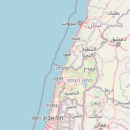
Map view of Yarkon-Tel Afek National Park

Use this park location map to pinpoint Yarkon-Tel Afek National Park in Israel, understand its exact geographic position, and read its mapped placement within the surrounding landscape more clearly.

Pigeon | © OpenStreetMap contributors
Park atlas

Trace the mapped geography of protected landscapes and historical sites across central Israel, comparing regional conservation contexts.

Discover Other National Parks and Protected Areas Near Yarkon-Tel Afek National Park in Central Israel

Browse national parks and protected areas in central Israel, featuring significant archaeological sites and riparian habitats near Yarkon-Tel Afek National Park. Discover how these diverse protected landscapes connect geographically, offering valuable insights into regional conservation patterns and the historical stratification of the area.
National parkPalestine
About 31 km away#1 closest

Northeast

Shomron National Park: Protected Landscape and Geographic Identity

Explore the terrain and mapped boundaries of this national park.

Shomron National Park preserves the natural landscape and archaeological remnants of the historic Samarian region. This protected area offers a glimpse into the characteristic terrain of the West Bank highlands, featuring rolling hills and rocky outcrops. Understand the geographic placement and protected land context of Shomron National Park within its regional setting.

IUCN
V
Relief
Mountain
Scope
Terrestrial
Watercolor painting of a river surrounded by grassy fields and distant hills with trees
National parkIsrael
About 33 km away#2 closest

North

Alexander River National Park: Israel's Protected Coastal Wetland and Sea Turtle Conservation Hub

Mapped riparian geography and vital protected landscape in Israel.

Alexander River National Park is a significant protected coastal wetland in Israel, focusing on the preservation of the lower Alexander River's unique riparian ecosystem. Renowned for its thriving populations of African softshell turtles and its role as the National Sea Turtle Rescue Center for endangered green sea turtles, the park offers a compelling case study in environmental rehabilitation. Users can explore the park's mapped boundaries, understand its geography as a transition zone between freshwater and marine environments, and appreciate its importance within the broader landscape of Mediterranean protected areas.

IUCN
V
Relief
Lowland
Climate
Mediterranean
Scope
Mixed
National parkIsrael
About 36 km away#3 closest

North

HaSharon Park National Park: Geographic Atlas and Protected Landscape Exploration in Israel

Discover the mapped terrain and regional context of HaSharon Park.

HaSharon Park is a national park providing a distinct protected landscape within Israel's borders. This entry supports a deeper understanding of its geographic setting and mapped natural terrain, contributing to the broader atlas of protected areas in the region. Users can explore the park's boundaries and its place within the national geography, gaining insights into the protected lands that characterize this part of the Levant.

Relief
Lowland
Access
Easy access
Scope
Terrestrial
Water
Major water bodies
National parkIsrael
About 39 km away#4 closest

Southeast

Ein Hemed National Park: Mapped Protected Landscape in Israel's Geography

Discover the natural terrain and park boundaries.

Ein Hemed National Park is a designated national park in Israel, providing valuable insight into its protected natural landscapes and regional geography. This entry focuses on understanding the park's physical setting and its mapped boundaries, essential for atlas-based exploration. Examine the terrain and discover the geographic significance of this protected area within the Israeli context.

Access
Access unknown
Scope
Terrestrial
National parkIsrael
About 40 km away#5 closest

Southeast

Castel National Park: A National Park for Geographic Discovery in Israel

Investigate the mapped protected landscape and regional terrain.

Castel National Park represents a key protected area within Israel, focusing on the discovery of its mapped terrain and geographic identity. As a national park, it serves as a crucial entity for understanding regional conservation landscapes and the distribution of protected areas across Israel. This detailed view allows for focused exploration of the park's boundaries and its contribution to the country's natural heritage, offering valuable context for atlas-based geographical inquiry.

Relief
Mountain
Climate
Mediterranean
Scope
Terrestrial
Water
No major water
Nature reserveJericho Governorate
About 50 km away#6 closest

East

Ain Al-Auja Nature Reserve: Mapping the Oasis Geography and Protected Ecosystems

Desert oasis and freshwater spring landscapes in Jericho Governorate

Ain Al-Auja Nature Reserve offers a distinct look at the intersection of highland escarpments and valley floor water systems. The protected landscape, defined by its perennial spring and surrounding medicinal flora, functions as a vital green corridor. View the mapped boundaries and terrain context of this significant desert oasis within the Jordan Valley network.

Area
22 km²
Access
Access unknown
Scope
Terrestrial
Water
Major water bodies
National parkIsrael
About 56 km away#7 closest

South

Beit Guvrin-Maresha National Park: A Mapped Exploration of Israel's Ancient Subterranean Heritage

Discover unique bell caves and archaeological landscape in the Judean lowlands.

Beit Guvrin-Maresha National Park in Israel presents a unique atlas-style discovery of a landscape defined by ancient human excavation. Explore the vast networks of bell caves, Phoenician necropolises, and Byzantine underground churches carved into the soft limestone hillsides. This protected area offers a compelling journey through millennia of history, revealing the geography and terrain shaped by continuous habitation and burial practices, making it a vital site for understanding regional archaeology and ancient cave systems.

IUCN
V
Water
No major water
National parkIsrael
About 57 km away#8 closest

Southeast

Herodion National Park: A Key National Park within Israel's Protected Landscape Atlas

Explore its mapped boundaries and geographic terrain.

Herodion National Park stands as a significant protected area within Israel, contributing vital context to the nation's atlas of natural landscapes. This national park designation highlights its role in conservation and offers a unique opportunity to study its specific geography, terrain, and mapped boundaries. By focusing on the park's protected landscape identity, users can gain structured insights into Israel's conservation efforts and regional geographic features, enhancing any atlas exploration.

Scope
Terrestrial

Common questions about visiting, size, designation, and location context for Yarkon-Tel Afek National Park

Yarkon-Tel Afek National Park FAQs for park facts, access, geography, and protected area context

Find quick answers about Yarkon-Tel Afek National Park, including protected-area facts, park geography, trail and visitor context, and how the park fits into its surrounding country and regional landscape.
MoriAtlas Explorer

Continue Your Protected Areas Search Across the Global Atlas

Deepen your exploration by continuing the structured search for national parks and protected areas worldwide. Utilize the comprehensive filtering capabilities to compare different conservation landscapes and refine your understanding of global park geography. Discover more about the distribution and characteristics of protected natural areas.

Global natural geography