Why HaSharon Park stands out
HaSharon Park is best known for preserving a remnant of the historic Sharon plain swamps that once covered the region and caused widespread malaria. The park's carob forest and Mount Tabor oak woodland represent native Mediterranean vegetation that has survived amid the transformed landscape. The contrast between the planted eucalyptus stands and the natural forest types creates a distinctive ecological character that illustrates the region's environmental history.
HaSharon Park history and protected-area timeline
The history of HaSharon Park is deeply intertwined with the broader reclamation of the Sharon plain's marshlands. The entire region was historically covered by extensive swamps that rendered the land unusable for agriculture and posed serious health risks due to malaria transmission. These wetlands were part of a larger system of coastal marshes that stretched along the Mediterranean coast of what is now Israel. In the early twentieth century, systematic drainage efforts were undertaken to transform these swampy lands into usable agricultural territory. Eucalyptus trees were planted extensively during this period because of their ability to absorb large quantities of groundwater and accelerate the drying process. These drainage operations fundamentally altered the ecological character of the region, converting disease-ridden wetlands into productive farmland. HaSharon Park preserves a portion of this transformed landscape, allowing visitors to see both the results of that environmental engineering and remnants of the natural vegetation that persists today.
HaSharon Park landscape and geographic character
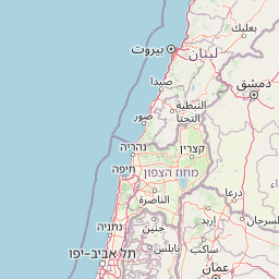
The landscape of HaSharon Park consists of a forested area dominated by carob and Mount Tabor oak trees, with a central lake providing open water habitat. The terrain is relatively flat, consistent with the coastal plain setting, though the forest creates a more varied visual environment with canopy cover and shaded areas beneath the trees. The eucalyptus plantings from the early twentieth century create distinct stands within the park, their tall forms contrasting with the broader-crowned carob and oak trees. The lake provides a focal point and breaks the forest cover, offering habitat for waterfowl and other wetland species. The park's boundaries are defined in part by the adjacent Alexander Stream, which adds a linear watercourse element to the broader landscape context.
HaSharon Park ecosystems, habitats, and plant life
The ecological character of HaSharon Park reflects a hybrid of historical wetland conditions and Mediterranean forest ecosystems. The carob tree is a Mediterranean native that produces distinctive seed pods and provides important habitat for wildlife, while the Mount Tabor oak is a deciduous oak species native to the region. The forest structure supports a variety of bird species and provides shelter for small mammals. The remnant wetland elements, particularly around the lake area, support different vegetation types than the drier forest areas. The early planted eucalyptus trees, while not native, have become established features that support their own ecological communities. The park represents a transitional ecosystem that developed after the drainage of the original swamp system, creating conditions that support both Mediterranean woodland species and remnant wetland organisms.
HaSharon Park wildlife and species highlights
The forest habitat within HaSharon Park supports populations of birds adapted to Mediterranean woodland environments. The carob and oak trees provide nesting sites and food resources for various songbird species, while the open water of the lake attracts waterfowl and wading birds. Small mammals likely inhabit the understory and forest floor, feeding on seeds, fruits, and insects. The remnant wetland areas, though greatly reduced from the historical swamp system, still provide habitat for amphibians and insects associated with moist environments. The park's position along the coast places it within migration routes for birds traveling between Europe and Africa, adding seasonal visitors to the resident wildlife population.
HaSharon Park conservation status and protection priorities
HaSharon Park represents the conservation of an important ecological and historical landscape within Israel's heavily developed coastal plain. While the original swamp ecosystem has been lost to drainage, the park preserves what's left of the forest that developed on reclaimed land and maintains connections to the remaining Alexander Stream corridor. The protection of this area ensures that the Mediterranean woodland character of the Sharon plain is not entirely lost to urban and agricultural development. The park also serves an educational function, allowing visitors to understand the historical environmental conditions of the region before the extensive modifications of the twentieth century. Conservation of this remnant forest patch is particularly significant given the intensive land use in the surrounding coastal plain.
HaSharon Park cultural meaning and human context
The cultural context of HaSharon Park is rooted in the transformation of the Israeli coastal plain from an unhealthy, malaria-ridden swamp region to productive agricultural land. The drainage of these wetlands was a major achievement of early Zionist settlement and agricultural development, opening up vast areas of the Sharon plain for cultivation and settlement. The eucalyptus trees planted to achieve this transformation have become symbolic of this effort in Israeli environmental history. The park preserves a tangible connection to this transformation, allowing visitors to experience the landscape that resulted from one of the most significant environmental engineering projects in the region's modern history.
Top sights and standout views in HaSharon Park
The standout features of HaSharon Park include its preserved carob and Mount Tabor oak forest, the central lake providing wetland habitat, and the historical eucalyptus trees dating to the early twentieth century drainage efforts. The park offers a rare opportunity to experience remnant natural vegetation in a region where most of the original landscape has been transformed by agriculture and development. The connection to the broader Alexander Stream protected corridor adds ecological context, while the park's location along a major highway makes it accessible for visitors interested in Israel's environmental heritage.
Best time to visit HaSharon Park
The best time to visit HaSharon Park is during the cooler months from October through April, when the Mediterranean climate provides comfortable conditions for outdoor exploration. During this period, the park's vegetation is at its most vibrant, and wildlife activity is higher than during the hot summer months. Winter and early spring may offer the most verdant landscape conditions, though rainfall can occasionally affect access. The summer months can be extremely hot and less suitable for prolonged outdoor activities in the park.