Mori Atlas logo
National parkCastel National Park

Discover the mapped terrain and regional context of this national park within Israel.

Castel National Park National Park: Explore Israel's Protected Landscape and Geography

Castel National Park stands as a significant protected landscape within Israel, offering a unique entry point for exploring its mapped boundaries and natural terrain. As a designated national park, it contributes to the country's network of conservation areas, providing a vital geographic context for understanding the region's diverse landscapes. This page serves as an atlas-driven resource to comprehend the park's identity and its role within Israel's protected land framework, facilitating discovery of its specific geographic features and the broader regional context.

Historic battlegroundMemorial siteAncient fortificationJudean MountainsArchaeological site1948 Arab-Israeli War

Castel National Park

National park

Park overview

Structured park overview, official facts, and landscape profile for Castel National Park

Castel National Park park facts, protected area profile, and essential visitor context
Review the core facts for Castel National Park, including designation, size, terrain, visitor scale, habitats, and operating context in one park-focused overview.

About Castel National Park

Castel National Park occupies a historically significant fortified summit in the Judean Mountains, approximately 8 kilometers west of Jerusalem along Highway 1. The park's name derives from the Hebrew HaCástel, meaning "the Castle," reflecting the site's long history as a fortified position controlling the vital road to Jerusalem. The park encompasses the ruins of ancient fortifications, including Roman and Crusader-era structures, as well as the remnants of the Arab village of Al-Qastal that existed on the hilltop during the Ottoman period. Beyond its archaeological significance, the park serves as a memorial to the soldiers who died during the 1948 war, with monuments and bronze plaques documenting the military events that shaped the region's modern history. The adjacent contemporary settlement of Maoz Zion, established in 1951 at the foot of the hill, anchors the site in the present while connecting it to the area's historical layers.

Quick facts and research context for Castel National Park

Castel National Park is located in the Judean Mountains region of Israel, positioned 8 kilometers west of Jerusalem on the main highway connecting Jerusalem to Tel Aviv. The park protects a fortified hilltop that has served as a strategic military position since the Roman period. The site is most famous for the fierce battles of April 1948 during Operation Nachshon, when control of the summit became crucial during the 1948 Arab-Israeli War. The park includes memorial structures honoring Israeli soldiers, including a monument designed in 1980 by Yitzhak Yamin, and features bronze plaques documenting the course of the fighting. The adjacent Jewish village of Maoz Zion was established at the foot of the hill in 1951.

Park context

Deeper park guide and search-rich context for Castel National Park

Castel National Park history, landscape, wildlife, and travel context
Explore Castel National Park through its history, landscape character, ecosystems, wildlife, conservation priorities, cultural context, and seasonal travel timing in a structured park guide built for atlas discovery and search intent.

Why Castel National Park stands out

Castel National Park is best known for its pivotal role in the 1948 Arab-Israeli War, specifically the battles of Operation Nachshon in April 1948. The strategic hilltop overlooking the main Tel Aviv-Jerusalem highway saw intense fighting as control of the site changed hands multiple times between Arab and Jewish forces. The park preserves the fortress ruins, defensive trenches, and a memorial complex that includes monuments to the fallen soldiers and to the convoys that attempted to break through the blockade of Jerusalem. The death of the revered Arab commander Abd al-Qadir al-Husayni during these battles marked a turning point in the conflict.

Castel National Park history and protected-area timeline

The strategic importance of Castel's hilltop position has attracted settlement and fortification since antiquity. The Romans established a fortress known as Castellum on the summit to secure their control over the road leading to Jerusalem. Following the Roman period, the Crusaders constructed a castle referred to in chronicles as Castellum Belveer, though no visible traces of this structure remain today. After the Crusader period, the site disappeared from historical records for centuries until an Arab village grew around the location during the Ottoman era, with the Mukhtar's house built on the hilltop near the ruins of the earlier fortifications. During the British Mandate period, the area was referred to as "The Castle" in English. The site gained its most celebrated historical significance during the 1947-1948 period when the Arab siege of Jerusalem made control of the Tel Aviv-Jerusalem road critical. Operation Nachshon in April 1948 saw fierce battles for the Castel, with the position changing hands multiple times before ultimately falling to Israeli forces on April 9, following the death of Arab commander Abd al-Qadir al-Husayni.

Castel National Park landscape and geographic character

Castel National Park sits atop a prominent hill in the Judean Mountains, a range that forms the central highlands of Israel between the coastal plain and the Dead Sea depression. The fortified summit offers commanding views over the Tel Aviv-Jerusalem corridor, making it a naturally defensible position that has attracted military fortification throughout history. The landscape features the rocky, terraced terrain typical of the Judean highlands, with ancient olive groves and Mediterranean scrub vegetation covering the slopes. The park contains the remains of stone fortifications, underground chambers, and trench networks dug during the 1948 conflicts. The surrounding area includes the modern village of Maoz Zion at the hill's base and connects to the urban edge of Jerusalem to the east.

Castel National Park ecosystems, habitats, and plant life

The natural environment of Castel National Park reflects the Mediterranean climate and terrain of the Judean Mountains. The park's vegetation includes characteristic Mediterranean scrubland with wild olive, carob, and various herbaceous plants adapted to the semi-arid conditions. While the park is primarily valued for its historical and memorial significance, the surrounding Judean Mountains support diverse wildlife including various bird species, reptiles adapted to rocky habitats, and small mammals. The park's location along the Jerusalem corridor places it within a transition zone between coastal and mountain ecosystems.

Castel National Park wildlife and species highlights

The Judean Mountains ecosystem that encompasses Castel National Park supports various wildlife species typical of the region. Birdlife includes species common to Mediterranean habitats, while the rocky terrain provides shelter for reptiles including lizards and snakes. Small mammals such as rodents and foxes inhabit the area's scrubland and rocky habitats. The park's historical and memorial focus means that wildlife observation is not the primary visitor draw, but the natural environment contributes to the site's atmosphere and provides ecological context to the historic landscape.

Castel National Park conservation status and protection priorities

Castel National Park is protected under Israel's national park system, preserving both the archaeological remains of ancient fortifications and the 1948 war memorial sites. The park's conservation significance lies in maintaining access to this historically important location while preserving the physical evidence of the military events that occurred there. The memorial complex, including monuments and bronze plaques, requires ongoing preservation to ensure the historical record remains accessible to visitors. The park balances its role as a historical memorial with its function as a protected natural area in the Judean Mountains.

Castel National Park cultural meaning and human context

Castel National Park occupies a location of profound cultural and historical significance that extends across multiple periods and communities. The site represents layers of human activity from Roman, Crusader, Ottoman, and modern Israeli periods. The park's memorial function honors the soldiers who died during the 1948 conflict while also preserving the physical landscape of that pivotal period. The relationship between the site's ancient fortified history and its more recent military events creates a cultural continuity of strategic importance that has shaped the region's development. The establishment of Maoz Zion village at the foot of the hill in 1951 demonstrates how the landscape has been reclaimed and reinhabited following the events of 1948.

Top sights and standout views in Castel National Park

The primary highlights of Castel National Park include the fortified hilltop with views over the Jerusalem corridor, the preserved fortress ruins dating to Roman and Crusader periods, and the memorial complex honoring soldiers from the 1948 war. Visitors can explore the trench networks and defensive positions that played critical roles during Operation Nachshon. The monument designed by Yitzhak Yamin in 1980 serves as a focal point for memorial activities. The bronze plaques distributed throughout the site provide historical context and documentation of the April 1948 battles. The combination of ancient fortification archaeology with 20th-century military history makes the park unique among Israel's historical sites.

Best time to visit Castel National Park

The best time to visit Castel National Park is during the spring and autumn months when temperatures are moderate and suitable for outdoor exploration of the hilltop site. Summer months can bring intense heat on the exposed summit, while winter may see rain and cooler conditions. Visitors seeking to avoid peak crowds should consider weekdays or early morning visits. The park is open during standard national park hours, and visitors interested in the memorial aspects may find early morning or late afternoon visits particularly atmospheric for reflection on the site's historical significance.
Park location guide

Geography guide, regional context, and park location map for Castel National Park

Castel National Park park geography, regions, and map view in Israel
Understand where Castel National Park sits in Israel through a broader geographic reading of the surrounding landscape, nearby location context, and its mapped position within the national park landscape.

How Castel National Park fits into Israel

Israel is a parliamentary republic in the Southern Levant, established in 1948 as a Jewish homeland. It borders Lebanon, Syria, Jordan, and Egypt, with Mediterranean coastline and access to the Red Sea. Jerusalem is the capital, though its status is contested, while Tel Aviv is the largest urban area. The country has a high-income economy with strong technology and innovation sectors.

Wider geography shaping Castel National Park in Israel

Israel occupies the Southern Levant region of West Asia. It is bordered by Lebanon to the north, Syria to the northeast, Jordan to the east, and Egypt to the southwest. The western coast lies on the Mediterranean Sea, while the southern tip reaches the Red Sea. The eastern border includes the Dead Sea, Earth's lowest point. The country occupies the West Bank, Gaza Strip, and Golan Heights.

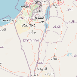
Map view of Castel National Park

Use this park location map to pinpoint Castel National Park in Israel, understand its exact geographic position, and read its mapped placement within the surrounding landscape more clearly.

Pigeon | © OpenStreetMap contributors

Location context for Castel National Park

Jerusalem District
Park atlas

Trace the mapped geography of protected landscapes and historic sites surrounding Castel National Park.

Explore Other National Parks and Protected Areas Near Castel National Park, Judean Mountains
Browse national parks and protected areas within the Judean Mountains and the broader region surrounding Castel National Park, tracing diverse historic sites and mountain landscapes. Comparing these protected landscapes provides essential geographic context for the Judean highlands, revealing how conservation efforts protect both natural and historically significant terrain.
National parkIsrael

Yarkon-Tel Afek National Park: Explore Its Protected Landscape and Israeli Geography

Mapped protected area and natural terrain context.

Gain a structured understanding of Yarkon-Tel Afek National Park, a designated national park within Israel. This detail entry focuses on its geographic identity and role as a protected landscape, providing essential context for atlas exploration. Understand the park's mapped boundaries and its contribution to the natural geography of the region without extraneous visitor details.

Scope
Terrestrial
Water
Minor water
Nature reserveJordan

Wadi Mujib Nature Reserve: Explore Jordan's Dramatic Canyon Protected Landscape

Discover mapped boundaries and arid biodiversity within this unique rift valley gorge.

Wadi Mujib Nature Reserve represents a significant protected landscape in Jordan, celebrated for its deep desert canyon and dramatic slot canyon terrain. Situated in the Dead Sea region, this reserve protects a remarkable range of geography, from its lowest points near the Dead Sea to surrounding mountain terrain. Its status as a UNESCO biosphere reserve highlights its importance for arid biodiversity and its role as a migratory bird flyway, offering a distinct atlas-level discovery of Jordan's natural heritage.

Area
212 km²
Established
1987
IUCN
IV
Relief
Mountain
Watercolor painting of rolling hills with pink, green, and purple hues
National parkIsrael

Ashkelon National Park: Ancient Coastal Protected Landscape and Archaeological Atlas

Explore mapped ruins, Fatimid walls, and Mediterranean coastal geography.

Ashkelon National Park in Israel offers a unique dive into ancient urban development, preserving layers of history from multiple civilizations along the Mediterranean coast. This protected area features landmark archaeological discoveries, including the Middle Bronze Age gate and extensive Roman ruins, all situated within a distinct coastal landscape. Understanding its mapped boundaries and the progression of its terrain provides critical context for appreciating this significant heritage site's geographic and historical importance.

IUCN
V
Relief
Lowland
Climate
Mediterranean
Access
Access unknown
Watercolor illustration showing a winding river through green hills with distant trees under a light sky
National park

Eshkol National Park: Desert Wetland Oasis with Archaeological Significance in Southern Israel

Mapped protected area featuring Ein HaBesor spring and Besor valley landscapes.

Eshkol National Park showcases a rare desert wetland environment sustained by the significant Ein HaBesor spring in Israel's Northern Negev. This protected natural area offers a distinctive landscape where water nourishes lush vegetation against the backdrop of arid terrain. Beyond its ecological value, the park encompasses archaeological remnants, including the mound of Khirbet Shalala, providing a rich geographical and historical discovery context within the Besor Stream basin.

Area
3.54 km²
Relief
Lowland
Climate
Arid
Access
Easy access
Nature reserveAjloun Governorate

Ajloun Forest Reserve: A Protected Mediterranean Woodland in Jordan's Ajloun Governorate

Explore the unique protected landscape and mapped terrain of Ajloun Forest Reserve.

Ajloun Forest Reserve is a nature reserve located in Jordan's Ajloun Governorate, distinguished by its rare Mediterranean woodland ecosystem. This protected area provides crucial habitat and showcases a landscape of rolling hills and valleys, offering a stark contrast to the country's predominantly arid regions. Its designation as a UNESCO biosphere reserve underscores its importance for conservation, including efforts in roe deer restoration and the preservation of the black iris, Jordan's national flower. Discover the geographic context and protected nature of this significant Jordanian landscape.

Area
13 km²
Established
1988
IUCN
IV
Relief
Highland
National parkIsrael

Mount Carmel National Park: Explore Israel's Protected Landscape and Geographic Atlas

Discover the mapped boundaries and natural terrain.

Mount Carmel National Park serves as a critical point for understanding protected areas and regional geography within Israel. This national park offers a detailed view of its specific landscape, mapped terrain, and protected boundaries, making it an essential component of any geographic exploration focused on the Levant. Investigate the park's unique features to enhance your understanding of conservation landscapes and their mapping within the Middle East.

Area
100 km²
Established
1960
Relief
Mountain
Climate
Mediterranean
Watercolor illustration of a canyon with winding river, mountains, and rolling hills
National parkIsrael

Ein Avdat National Park: A Spectular Desert Oasis and Protected Landscape in Israel

Explore its unique springs, waterfalls, and ancient Nabatean and Byzantine history.

Ein Avdat National Park showcases a rare desert oasis environment, a starkly beautiful protected landscape where natural springs emerge from the Negev's arid terrain. This park is celebrated for its dramatic waterfalls, deep pools, and the preserved remnants of ancient human habitation, including a remarkable Byzantine cave monastery carved directly into the canyon walls. Its geography, shaped by the Nahal Zin wadi, provides a vivid study in desert ecosystems and their capacity for supporting life and history over millennia, making it a key site for understanding landscape context in Israel.

Area
4.8 km²
IUCN
V
Relief
Mixed relief
Climate
Arid
Watercolor illustration of a mountainous landscape with multiple colored terrain layers
Biosphere reserveJordan

Dana Biosphere Reserve: Mapped Biosphere Reserve in Jordan's Geography

Explore protected landscape boundaries and regional context.

Dana Biosphere Reserve is a critical protected landscape in Jordan, recognized for its significant geographic features and ecological value. This page offers detailed insights into its mapped boundaries and its place within the broader regional geography of the Middle East. It serves as an essential resource for understanding the park's protected-area identity and its contribution to Jordan's natural heritage, facilitating a deeper atlas-driven exploration of its terrain and conservation significance.

Area
308 km²
Established
1989
Relief
Mixed relief
Scope
Terrestrial

Common questions about visiting, size, designation, and location context for Castel National Park

Castel National Park FAQs for park facts, access, geography, and protected area context
Find quick answers about Castel National Park, including protected-area facts, park geography, trail and visitor context, and how the park fits into its surrounding country and regional landscape.
MoriAtlas Explorer

Continue Your Protected Areas Search Across the Global Atlas

Deepen your exploration by continuing the structured search for national parks and protected areas worldwide. Utilize the comprehensive filtering capabilities to compare different conservation landscapes and refine your understanding of global park geography. Discover more about the distribution and characteristics of protected natural areas.

Global natural geography