

Mori Atlas logo
Protected areaZugvogelschutzgebiet Upper Rousay Lake

A detailed look at the protected terrain, wetland boundaries, and landscape configuration.

Zugvogelschutzgebiet Upper Rousay Lake Protected Area: Mapping Regional Wetland Geography

(Upper Rousay Lake Migratory Bird Sanctuary)

The Zugvogelschutzgebiet Upper Rousay Lake protected area represents a specific geographic unit within the Estonian landscape. Our atlas provides a structured view of these protected boundaries, allowing for a clearer understanding of how the terrain is integrated into the broader regional environment. This analysis focuses on the spatial extent and natural characteristics of the site, providing essential context for those examining protected land configurations.

migratory bird sanctuarywetlandshallow lakewaterfowl habitatshorebirdsgrebes

Zugvogelschutzgebiet Upper Rousay Lake

Protected area

Park overview

Structured park overview, official facts, and landscape profile for Upper Rousay Lake Migratory Bird Sanctuary

Upper Rousay Lake Migratory Bird Sanctuary park facts, protected area profile, and essential visitor context

Review the core facts for Upper Rousay Lake Migratory Bird Sanctuary, including designation, size, terrain, visitor scale, habitats, and operating context in one park-focused overview.

About Upper Rousay Lake Migratory Bird Sanctuary

The Upper Rousay Lake Migratory Bird Sanctuary is a compact but ecologically important wetland reserve in the Canadian province of Saskatchewan. Although it covers a relatively small area, the sanctuary punchs well above its weight in terms of waterbird conservation value, because it protects a slice of one of the more productive shallow wetland complexes in the Aspen Parkland ecoregion.

The protected area centers on the upper portion of Rousay Lake, a shallow prairie basin with an average depth of only about half a meter. Around 55 percent of the sanctuary is open water, while the remaining 45 percent consists of sedge meadows, giving the landscape a finely balanced mosaic of aquatic and emergent habitats. The shoreline is irregular and richly structured, with numerous bays, peninsulas, and temporary islands that naturally shelter waterbird nests. On top of this natural complexity, Ducks Unlimited Canada has constructed additional artificial islands to enhance nesting habitat, making the site a textbook example of habitat management working alongside natural wetland processes.

The sanctuary sits in an agriculturally significant part of eastern Saskatchewan, roughly six kilometers west-southwest of the city of Yorkton. This eastern parkland region, where prairie grasslands meet boreal forest influence, is known for its seasonal wetlands that are critical to numerous waterfowl and shorebird species. Protecting Upper Rousay Lake therefore serves a dual purpose: it insulates a key wetland from the drainage and cultivation pressures that have affected many similar sites in the region, and it preserves a reliable staging area for migratory birds moving through the northern prairies.

The reserve is administered by the Canadian Wildlife Service as a migratory bird sanctuary under Canada's migratory bird protection framework. It is classified as an IUCN Category IV area, reflecting its managed nature and its primary focus on habitat and species conservation rather than on strict ecological preservation. Despite its small footprint, the sanctuary plays a role in the broader network of Canadian migratory bird sanctuaries that collectively maintain breeding, molting, and stopover habitat across the continent's flyways.

Quick facts and research context for Upper Rousay Lake Migratory Bird Sanctuary

Upper Rousay Lake Migratory Bird Sanctuary is a 5.73 square kilometer migratory bird sanctuary in east-central Saskatchewan, Canada, administered by the Canadian Wildlife Service. It sits in the Aspen Parkland ecoregion and protects part of a shallow lake and sedge meadow complex about six kilometers west-southwest of Yorkton. The sanctuary was created on November 3, 1948, replacing earlier bird sanctuaries that had become unsuitable due to drought, and is classified as IUCN Category IV. Roughly 55 percent of the protected area is open water and 45 percent is sedge meadow, with an average water depth of about half a meter, and the area includes bays, peninsulas, temporary islands, and artificial nesting islands built by Ducks Unlimited Canada.

Protection and recognition

Documented terrestrial protection scope and international designation facts

Zugvogelschutzgebiet Upper Rousay Lake Protection Status and Records

Zugvogelschutzgebiet Upper Rousay Lake maintains a documented terrestrial protection scope within global conservation databases. Verified records outline the established designation framework and administrative parameters governing the protected area.

Protection details

Protection scope
Terrestrial
Transboundary protection
No
WDPA ID
67437
Park context

Deeper park guide and search-rich context for Upper Rousay Lake Migratory Bird Sanctuary

Upper Rousay Lake Migratory Bird Sanctuary history, landscape, wildlife, and travel context

Explore Upper Rousay Lake Migratory Bird Sanctuary through its history, landscape character, ecosystems, wildlife, conservation priorities, cultural context, and seasonal travel timing in a structured park guide built for atlas discovery and search intent.

Why Upper Rousay Lake Migratory Bird Sanctuary stands out

Upper Rousay Lake is best known as a productive prairie wetland breeding and molting ground for waterfowl and as a fall staging area for migratory birds. Its shallow open water interspersed with sedge meadows, bays, and managed islands creates ideal nesting and feeding conditions for dabbling ducks, Canada geese, grebes, and a wide variety of shorebirds. The sanctuary's location within the broader Aspen Parkland wetlands also gives it significance as a stopover site along migratory flyways crossing the northern prairies.
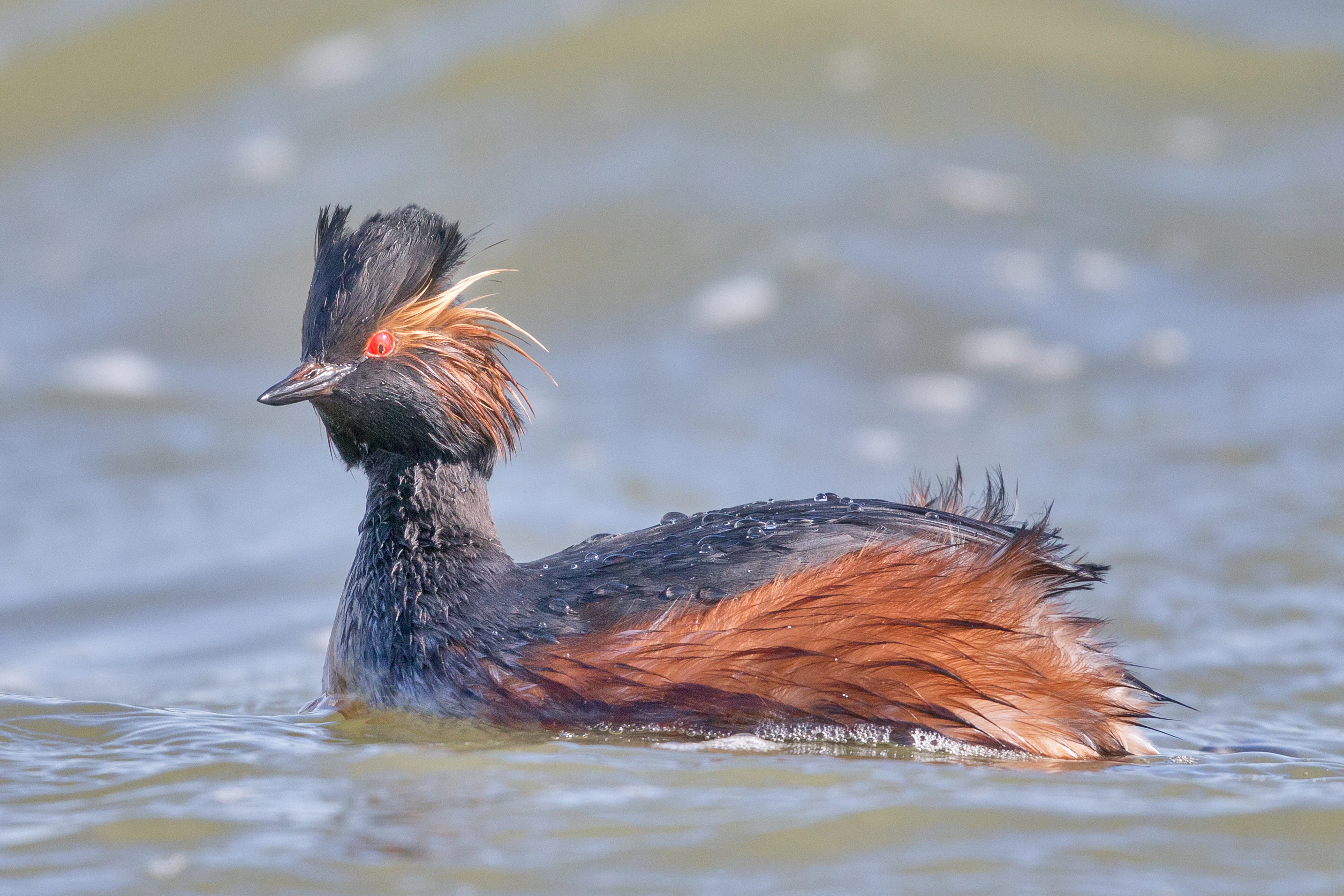
A black-necked grebe with distinctive black head and golden-brown fan-shaped cheek feathers swimming in calm water.
A black-necked grebe swimming in the water of Upper Rousay Lake.

Upper Rousay Lake Migratory Bird Sanctuary history and protected-area timeline

The Upper Rousay Lake Migratory Bird Sanctuary was established on November 3, 1948, as one of five new bird sanctuaries created in Saskatchewan on the same date. These sanctuaries were set up to replace five earlier migratory bird sanctuaries in the province that had become unsuitable for waterbird conservation due to recurring drought, which had reduced water levels and degraded habitat at the original sites.

The sanctuary is administered by the Canadian Wildlife Service, the federal agency responsible for migratory bird conservation in Canada. Over time, habitat management interventions, including the construction of artificial islands by Ducks Unlimited Canada, have supplemented the natural wetland character of the site, improving its value for nesting waterfowl. Its institutional setting remains that of a federally managed migratory bird sanctuary, integrated into Canada's long-standing system of wetlands protected for breeding and migratory waterbirds.

Upper Rousay Lake Migratory Bird Sanctuary landscape and geographic character

The landscape of the Upper Rousay Lake sanctuary is defined by a shallow prairie lake and its associated wetland margins. Upper Rousay Lake has an average water depth of about half a meter, making it a warm, productive body of water in summer and relatively easy for waterbirds to use for feeding. Approximately 55 percent of the sanctuary consists of open water, while the remaining 45 percent is made up of sedge meadows, which form dense emergent vegetation around the lake margins and across shallow sections.

The shoreline is highly irregular, with numerous bays, peninsulas, and temporary islands that give the wetland a varied and structurally complex edge. Submerged and emergent vegetation patterns, combined with shallow bays, create sheltered nesting and brood-rearing habitat. The neighboring Lower Rousay Lake lies just to the southeast but is not part of the sanctuary, leaving the protected area focused tightly on the upper lake basin. Ducks Unlimited Canada has added artificial nesting islands in the sanctuary to enhance the natural island and peninsula complex and to improve nesting success.

Upper Rousay Lake Migratory Bird Sanctuary ecosystems, habitats, and plant life

Ecologically, the sanctuary sits within the Aspen Parkland ecoregion, a transitional zone between the open prairies to the south and west and the boreal forest to the north. This region is characterized by a mix of grassland, aspen woodland, shrubby margins, and wetlands, many of which are seasonal or semi-permanent. Upper Rousay Lake represents one of the more permanent wetland features in this landscape, and its combination of open water and sedge meadow is typical of high-value prairie parkland wetlands.

The protected area is part of a larger wetland complex made up of shallow, interconnected water bodies. This connectivity is ecologically important because it allows waterfowl, especially broods of young ducks and geese, to move between feeding and sheltering habitats as water levels and seasonal conditions change. The variety of habitats, from open water through shallow bays to dense sedge, supports a broader mix of species than a simple open-water or meadow system would.

Upper Rousay Lake Migratory Bird Sanctuary wildlife and species highlights

The sanctuary is recognized as an ideal breeding and molting area for waterfowl. Large numbers of ducks, especially mallards, and Canada geese visit the site annually for breeding, and they also use it as a resting and feeding area during the fall migration. The combination of sheltered bays, sedge cover, and artificial nesting islands makes the lake particularly suitable for species that prefer shallow, vegetated wetlands.

Several species of grebes are recorded as breeding birds in the sanctuary, including black-necked grebe, horned grebe, and red-necked grebe, the latter two of which are featured in wildlife imagery associated with the site. Other breeding marshland birds reported from the sanctuary include the sora, marsh wren, red-winged blackbird, and yellow-headed blackbird. Breeding or probably breeding shorebirds include Wilson's phalarope, marbled godwit, killdeer, Wilson's snipe, upland sandpiper, willet, spotted sandpiper, Baird's sandpiper, and black-necked stilt, illustrating the diversity of wader habitats the wetland provides.

In summer the sanctuary also hosts visiting species such as great blue heron, black-crowned night heron, least bittern, common loon, red-throated loon, American white pelican, ring-billed gull, and Bonaparte's gull. During migration, additional shorebirds appear on the lakeshore and adjacent meadows, including American golden plover, lesser yellowlegs, greater yellowlegs, stilt sandpiper, pectoral sandpiper, least sandpiper, and solitary sandpiper. Together, these records position the sanctuary as an unusually rich wetland bird site for its size within Saskatchewan.

Upper Rousay Lake Migratory Bird Sanctuary conservation status and protection priorities

The Upper Rousay Lake sanctuary holds clear conservation value as a stable refuge for migratory waterbirds in a landscape where many natural wetlands have been lost or degraded through drainage, cultivation, and recurring drought. Its protected status under the Canadian migratory bird sanctuary system gives the wetland formal legal protection from activities that would otherwise threaten waterbird habitat, including wetland drainage and uncontrolled water-level changes.

Its IUCN Category IV designation, Habitat or Species Management Area, reflects the sanctuary's primary conservation objective. Rather than being preserved as untouched wilderness, the area is actively managed to maintain or enhance habitat conditions for waterbirds, including engineering interventions such as the artificial nesting islands built by Ducks Unlimited Canada. This combination of legal protection and active habitat management is typical of migratory bird sanctuaries in settled agricultural regions, where simply preventing disturbance is not sufficient to ensure long-term habitat quality.

The sanctuary also plays a role in climate resilience for waterbird populations. By protecting a permanent shallow wetland in a region historically affected by drought-driven loss of earlier sanctuaries, it provides a more dependable habitat anchor than the original sites it replaced. Its continued importance for breeding, molting, and migration underscores its place within the wider federal strategy of maintaining a network of wetland refugia across Canada's flyways.

Top sights and standout views in Upper Rousay Lake Migratory Bird Sanctuary

The sanctuary's strongest qualities lie in its combination of shallow open water and dense sedge meadow, its irregular shoreline of bays, peninsulas, and islands, and its record of supporting multiple grebe species alongside large numbers of breeding ducks and Canada geese. The active habitat management by Ducks Unlimited Canada, including artificial islands, distinguishes it as a managed rather than purely preserved wetland, while its location within the Aspen Parkland links it ecologically to one of Canada's most important transitional ecoregions. Its longevity, dating back to 1948, also marks it as one of the older sanctuary sites in the Saskatchewan migratory bird network.

Best time to visit Upper Rousay Lake Migratory Bird Sanctuary

The most ecologically meaningful periods to experience Upper Rousay Lake are late spring through summer, when breeding waterfowl, grebes, and shorebirds are present in the wetland, and early to mid fall, when the sanctuary functions as a staging and feeding area for ducks, geese, and migrating shorebirds. Summer visits coincide with peak waterbird activity and the lush growth of sedge meadows. Winter in this part of Saskatchewan is long and cold, and the shallow lake characteristically freezes, which dramatically reduces its accessibility and waterbird use.

Monthly climate preview

Long-term representative monthly temperature and precipitation records for Estonia

Zugvogelschutzgebiet Upper Rousay Lake Climate Normals and Annual Temperature Range

Measured coordinates at Zugvogelschutzgebiet Upper Rousay Lake reveal a pronounced annual thermal range spanning from sub-zero winter minimums to warm summer maximums alongside varying daily precipitation rates. Examining the full twelve-month profile provides deeper analytical context on long-term climate normals and seasonal variations across the protected landscape.
Annual mean3 °C
-16 °C19 °C
Jan-16°
Feb-13°
Mar-5°
Apr
May11°
Jun16°
Jul19°
Aug19°
Sep12°
Oct
Nov-5°
Dec-13°
Warmest month
July

19.5 °C

Coolest month
January

-16.2 °C

Wettest month
June

3.2 mm/day

Driest month
February

0.5 mm/day

Park location guide

Geography guide, regional context, and park location map for Upper Rousay Lake Migratory Bird Sanctuary

Upper Rousay Lake Migratory Bird Sanctuary park geography, regions, and map view in Estonia

Understand where Upper Rousay Lake Migratory Bird Sanctuary sits in Estonia through a broader geographic reading of the surrounding landscape, nearby location context, and its mapped position within the national park landscape.

How Upper Rousay Lake Migratory Bird Sanctuary fits into Estonia

Estonia is a parliamentary republic and member of the European Union and NATO. With a population of about 1.4 million, it is one of the least populous EU member states. The official language is Estonian, and the currency is the Euro.

Wider geography shaping Upper Rousay Lake Migratory Bird Sanctuary in Estonia

Estonia is situated on the eastern coast of the Baltic Sea in Northern Europe. It borders the Gulf of Finland to the north, Latvia to the south, and Russia to the east. The territory includes the mainland, the islands of Saaremaa and Hiiumaa, and over 2,300 smaller islands and islets.

Map view of Upper Rousay Lake Migratory Bird Sanctuary

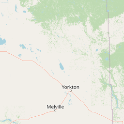
Use this park location map to pinpoint Upper Rousay Lake Migratory Bird Sanctuary in Estonia, understand its exact geographic position, and read its mapped placement within the surrounding landscape more clearly.

Pigeon | © OpenStreetMap contributors

Visual reference of wetland habitats, shallow waters, and protected park terrain

Zugvogelschutzgebiet Upper Rousay Lake Photos and Landscape Scenery

Examine detailed photographs showcasing the wetland habitats, shallow open waters, and sedge meadows of Zugvogelschutzgebiet Upper Rousay Lake. Visual documentation reveals the protected terrain, irregular shorelines, and environmental character of this prairie sanctuary.

A black-necked grebe with distinctive black head and golden-brown fan-shaped cheek feathers swimming in calm water.

Park atlas

Discover adjacent wetland reserves, shallow lake ecosystems, and regional prairie protected areas.

Explore Parks Near Zugvogelschutzgebiet Upper Rousay Lake and Related Protected Landscapes

Compare Zugvogelschutzgebiet Upper Rousay Lake with other regional protected areas sharing similar shallow wetland terrain and waterfowl habitats. Broaden your geographic understanding of local conservation landscapes by examining nearby natural reserves and interconnected wildlife sanctuaries.
National parkManitoba
About 106 km away#1 closest

East

Riding Mountain National Park: Manitoba National Park Protected Landscape and Geography

Discover mapped boundaries and regional context for this national park.

Delve into the geography of Riding Mountain National Park, a protected national park located in Manitoba. This page provides detailed insights into its mapped boundaries and its significance as a protected landscape within the region. Understand its place within the broader natural terrain and atlas context of Manitoba, offering a focused view for geographic exploration and conservation landscape study.

Area
2,969 km²
Established
1933
IUCN
II
Visitors
336.6K annual
Wildlife reserveSaskatchewan
About 109 km away#2 closest

Southwest

Zugvogelschutzgebiet Indian Head: A Wildlife Reserve in Saskatchewan Prairie Landscapes

Examining mapped boundaries and protected wetland terrain

Zugvogelschutzgebiet Indian Head represents a significant conservation footprint within the Saskatchewan prairie region. This wildlife reserve integrates managed wetlands and historic nursery grounds, showcasing how agricultural landscapes support migratory bird populations. Gain insight into its terrain, ecoregion placement, and the geographic history of these protected lands through our structured atlas data.

Area
0.32 km²
Established
1924
Relief
Lowland
Scope
Terrestrial
Wildlife reserveSaskatchewan
About 140 km away#3 closest

South

Moose Mountain Creek National Wildlife Area Protected Habitat and Geographic Atlas

A preserved prairie wetland complex in southeastern Saskatchewan.

Moose Mountain Creek National Wildlife Area is a federal reserve in Saskatchewan that protects a rare assembly of four distinct habitat types. The land features a functional mix of freshwater marshes, native mixed-grass prairie, and trembling aspen groves. This structured protected area highlights the importance of preserving remnant prairie ecosystems within a broader agricultural region, providing a critical baseline for understanding local geography.

Area
1.63 km²
Established
2025
IUCN
IV
Relief
Lowland
Wildlife reserveSaskatchewan
About 164 km away#4 closest

Southwest

Wascana Lake Migratory Bird Sanctuary: Geographic Overview and Protected Wetland Boundaries

A vital wildlife reserve located in Regina, Saskatchewan

Explore the unique geography of Wascana Lake Migratory Bird Sanctuary, where a managed reservoir creates a rich wetland habitat for migratory waterfowl. This protected area stands as a significant ecological site within the Saskatchewan prairie landscape, offering a rare look at riparian terrain integration inside a major urban center.

Area
1.04 km²
Established
1956
Relief
Lowland
Climate
Temperate
Wildlife reserveSaskatchewan
About 170 km away#5 closest

North

Neely Lake Migratory Bird Sanctuary: Boreal Wetland Geography and Protected Landscapes

Essential protected area data for the eastern Saskatchewan boreal fringe

Neely Lake Migratory Bird Sanctuary encompasses a shallow freshwater environment defined by marshy shorelines, wet meadows, and small islands. Situated within the Mid-Boreal Upland, this protected landscape provides crucial stopover habitat for waterfowl moving through the Prairie and Boreal flyways. Gain insight into the terrain, water-body structure, and ecological role of this significant Canadian wildlife reserve.

Area
5.02 km²
Established
1952
IUCN
IV
Wildlife reserveSaskatchewan
About 218 km away#6 closest

Northwest

Raven Island National Wildlife Area: Geographic Overview and Protected Island Landscape

Essential conservation geography within Saskatchewan

Located in the saline prairie basins of central Saskatchewan, Raven Island National Wildlife Area is a 112-hectare protected habitat. This site plays a strategic role in the Lenore Lake migratory bird complex, preserving crucial island breeding grounds within a gentle prairie landscape. Explore the physical boundaries and ecological context of this Canadian wildlife reserve.

Area
1.12 km²
Established
1982
IUCN
IV
Scope
Terrestrial
Wildlife reserveSaskatchewan
About 267 km away#7 closest

Northwest

St. Denis National Wildlife Area: Geographic Profile and Protected Prairie Landscape

A research-focused wildlife reserve in central Saskatchewan.

St. Denis National Wildlife Area represents a critical nexus for prairie ecology, defined by its dense network of shallow ponds and native grassland communities. As a dual-designated National Wildlife and Research Area, this site offers a clear window into the delicate balance of wetland habitats, saline soil conditions, and agricultural landscape integration across Saskatchewan.

Area
3.6 km²
Established
1967
IUCN
IV
Wildlife reserveNorth Dakota
About 282 km away#8 closest

South

Lostwood Wilderness Wildlife Reserve and Prairie Pothole Landscape Geography

Protected northern mixed grass prairie in North Dakota

Lostwood Wilderness protects a unique mosaic of native grasslands and shallow wetlands in northwestern North Dakota. As an essential part of the National Wilderness Preservation System, it preserves a roadless, undeveloped window into the prairie pothole region, offering a clear view of the natural terrain and conservation character of the northern Great Plains.

Area
22.57 km²
Established
1975
IUCN
Ib
Relief
Lowland

Common questions about visiting, size, designation, and location context for Upper Rousay Lake Migratory Bird Sanctuary

Upper Rousay Lake Migratory Bird Sanctuary FAQs for park facts, access, geography, and protected area context

Find quick answers about Upper Rousay Lake Migratory Bird Sanctuary, including protected-area facts, park geography, trail and visitor context, and how the park fits into its surrounding country and regional landscape.
MoriAtlas Explorer

Continue Your Protected Areas Search Across the Global Atlas

Deepen your exploration by continuing the structured search for national parks and protected areas worldwide. Utilize the comprehensive filtering capabilities to compare different conservation landscapes and refine your understanding of global park geography. Discover more about the distribution and characteristics of protected natural areas.

Global natural geography
