Mori Atlas logo
Protected areaAllegheny National Recreation Area

Mapping the forested plateaus, reservoir shorelines, and river corridors of northwestern Pennsylvania

Allegheny National Recreation Area: A Protected Landscape within the Pennsylvania Highlands

The Allegheny National Recreation Area encompasses significant tracts of the Allegheny Plateau, serving as a primary protected landscape within the northwestern reaches of Pennsylvania. This area connects expansive reservoir waters with dense northern hardwood forests, offering a unique geographic cross-section of the Allegheny National Forest. Through these mapped territories, travelers can examine the interplay between the Allegheny River watershed and the rugged, elevated terrain that defines this regional Highland ecosystem.

national recreation areaAllegheny PlateauAllegheny National ForestAllegheny ReservoirAllegheny RiverKinzua Dam

Allegheny National Recreation Area

Protected area

Park overview

Structured park overview, official facts, and landscape profile for Allegheny National Recreation Area

Allegheny National Recreation Area park facts, protected area profile, and essential visitor context

Review the core facts for Allegheny National Recreation Area, including designation, size, terrain, visitor scale, habitats, and operating context in one park-focused overview.

About Allegheny National Recreation Area

The Allegheny National Recreation Area is a protected recreation-focused unit of the National Forest System in northwestern Pennsylvania. Sitting on the Allegheny Plateau in Warren and McKean Counties, it is administered by the United States Forest Service and functions as a distinct designation overlaid on portions of the Allegheny National Forest. The recreation area provides outdoor opportunities centered on large reservoirs, river corridors, trails, and expansive northern hardwood forest.

Rather than being a single continuous block, the recreation area is composed of separate parcels distributed across the forest. The northern unit is anchored by the Allegheny Reservoir, a sizeable impoundment upstream of Kinzua Dam, while a southern unit runs along the east bank of the Allegheny River south of the city of Warren. This fragmented but strategically placed arrangement allows the recreation area to capture some of the most scenically and recreationally valuable terrain within the broader national forest.

The landscape is shaped by the dissected plateau topography typical of northwestern Pennsylvania, with rolling ridges, steep stream valleys, and long stretches of forest broken only by water features and small clearings. The result is an environment oriented toward hiking, boating, fishing, hunting, and dispersed backcountry use rather than concentrated visitor infrastructure.

Because it shares its administrative base with the Allegheny National Forest, the recreation area is closely tied to the identity of that larger forest. However, its separate national recreation area designation gives it a stronger emphasis on active outdoor recreation and on preserving large blocks of forest and water in a region where such landscapes have historically been heavily altered by timber, oil, and gas activity.

Quick facts and research context for Allegheny National Recreation Area

The Allegheny National Recreation Area is a national recreation area located in Warren and McKean Counties in northwestern Pennsylvania, with the nearest city being Warren. It sits on the Allegheny Plateau and is administered by the United States Forest Service as a component of the Allegheny National Forest.

The area consists of multiple separate parcels of land within the forest, divided into units associated with the Allegheny Reservoir upstream of Kinzua Dam and the upper Allegheny River south of Warren. It was established by the Pennsylvania Wilderness Act of 1984 and remains one of the few national recreation areas in the eastern United States.

Protection and recognition

Terrestrial protected area classification, management scope, and status metrics

Allegheny National Recreation Area Protection Status and Formal Recognition Data

Allegheny National Recreation Area maintains documented terrestrial protection status across its regional landscape boundaries. Verified conservation records track administrative parameters, management frameworks, and official international recognition listings where established.

Protection details

Protection scope
Terrestrial
Transboundary protection
No
Park context

Deeper park guide and search-rich context for Allegheny National Recreation Area

Allegheny National Recreation Area history, landscape, wildlife, and travel context

Explore Allegheny National Recreation Area through its history, landscape character, ecosystems, wildlife, conservation priorities, cultural context, and seasonal travel timing in a structured park guide built for atlas discovery and search intent.

Why Allegheny National Recreation Area stands out

The recreation area is best known for the forested shoreline of the Allegheny Reservoir, the scenic upper Allegheny River corridor south of Warren, and its role as a recreation-oriented overlay within the larger Allegheny National Forest. It offers long-distance trail experiences, including segments of the North Country Trail, set within a broad plateau landscape of hardwood forest, streams, and reservoir water. The area is also notable as one of only two national recreation areas in the eastern United States, giving it a distinctive administrative identity within the National Forest System. Its combination of backcountry terrain, water-based recreation, and extensive forest tracts makes it a defining outdoor destination in northwestern Pennsylvania.
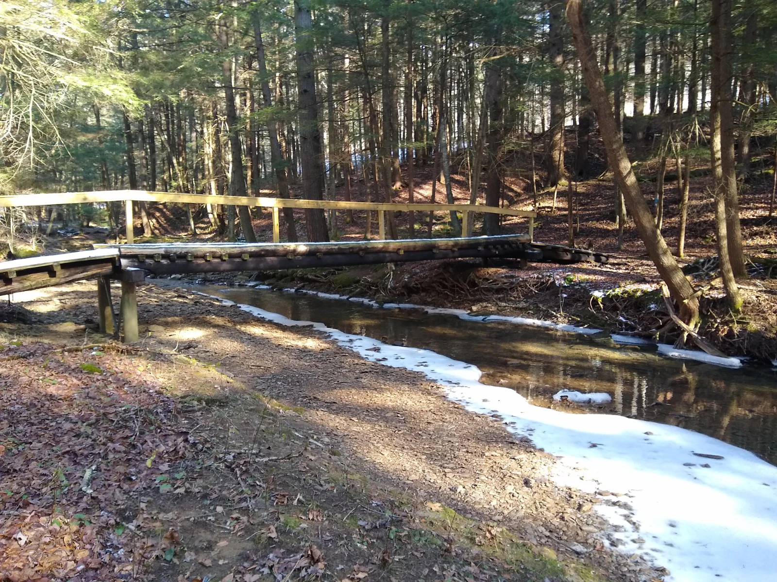
A simple wooden footbridge with a handrail spans a small, shallow stream in a wooded area, with fallen leaves covering the forest floor.
A wooden footbridge crossing Nelse Run on the North Country Trail at Tracy Ridge.

Allegheny National Recreation Area history and protected-area timeline

The Allegheny National Recreation Area was established in 1984 through the Pennsylvania Wilderness Act, Public Law 98-585. Its creation was the work of Congressman Bill Clinger, Senator Arlen Specter, and Senator John Heinz, who together advanced the legislation that set the recreation area apart as a formally designated unit within the Allegheny National Forest.

The 1984 act drew on a long regional history of forest use and recovery in northwestern Pennsylvania, where much of the original forest had been cleared for timber, agriculture, and later oil and gas development. Establishing a national recreation area reflected an effort to protect large forest blocks, water resources, and recreation opportunities in a part of the country where federal recreation lands of this scale are uncommon.

By overlaying the recreation area designation on existing national forest lands rather than carving out an entirely new jurisdiction, the legislation allowed the unit to benefit from the established management framework of the United States Forest Service while still gaining a distinct identity and policy focus.

Allegheny National Recreation Area landscape and geographic character

The recreation area lies on the Allegheny Plateau, a dissected upland region characterized by rolling ridges, narrow stream valleys, and long forested ridgelines. Elevations across the plateau vary gradually rather than dramatically, producing a landscape of broad swells and hollows rather than sharp mountain crests, while the valleys cut by rivers and streams add structural variety.

Water is a defining element of the terrain. The Allegheny Reservoir, formed upstream of Kinzua Dam, gives the northern unit an expansive shoreline of forested coves, points, and inlets. To the south, the Allegheny River forms a narrower but no less central corridor, with steep wooded banks and backwaters shaping the character of that district.

Forest cover dominates the visual experience of the area. Continuous tracts of second-growth northern hardwoods and associated mixed forests stretch across ridgelines and valley walls, broken primarily by streams, reservoirs, and scattered clearings. The result is a deeply wooded, water-threaded plateau landscape typical of Pennsylvania's northwestern highlands.

Allegheny National Recreation Area ecosystems, habitats, and plant life

The vegetation of the Allegheny National Recreation Area reflects the broader ecological character of the Allegheny Plateau, with extensive northern hardwood forest communities dominating most of the landscape. Tree species typical of eastern upland forests, including mixed hardwoods and, in some areas, hemlock along stream valleys, form the structural backbone of the area's habitat.

The reservoir and river corridors introduce distinct aquatic and shoreline habitats that differ sharply from the surrounding forest. fluctuations in water levels around the Allegheny Reservoir create transitional zones between open water, exposed shorelines, and forested banks, while the upper Allegheny River supports riparian habitat along its wooded corridor south of Warren.

Wetlands, seeps, and small tributaries further diversify the ecological mosaic. These features are embedded within an otherwise largely forested setting, making the area a patchwork of upland forest, riparian zones, and water-driven habitats rather than a uniform woodland.

Allegheny National Recreation Area wildlife and species highlights

The heavily forested terrain and the mix of river, reservoir, and upland habitats support wildlife typical of the northern Appalachian region. Forest-dependent species use the large blocks of contiguous hardwood cover that define much of the recreation area, while waterfowl, shorebirds, fish, and other aquatic-associated species concentrate around the Allegheny Reservoir and the upper Allegheny River.

The reservoir itself is an important feature for fish populations and for water-oriented wildlife, and the surrounding forest provides habitat for a wide range of familiar eastern woodland species. Stream valleys and backcountry areas also offer less disturbed conditions for species that benefit from interior forest cover.

Because the recreation area is intertwined with the Allegheny National Forest, its wildlife functions as part of a much larger forest ecosystem. The protected status of the recreation area helps maintain habitat continuity across routes and disturbed lands, sustaining wildlife populations across a broader northwestern Pennsylvania landscape.

Allegheny National Recreation Area conservation status and protection priorities

The designation of the Allegheny National Recreation Area reflects an effort to anchor large-scale forest and water conservation in a part of Pennsylvania historically shaped by intensive resource extraction. By formally setting aside recreation area parcels within the Allegheny National Forest, the 1984 Pennsylvania Wilderness Act reinforced the role of federal forest lands as a long-term refuge for northern hardwood ecosystems, river and reservoir habitat, and the species that depend on them.

The recreation area's value from a conservation perspective is closely linked to its scale and configuration. The northern district around the Allegheny Reservoir protects a substantial block of forested shoreline and adjacent uplands, while the southern district along the Allegheny River preserves a long stretch of river corridor and surrounding plateau forest. Together, these areas help maintain habitat continuity and ecological function across a region where forest fragmentation has been a recurring challenge.

Its status as one of only a handful of national recreation areas in the eastern United States also gives it a conservation profile distinct from that of typical national forest lands, emphasizing the integration of recreation, water resources, and forest habitat protection in a single designation.

Allegheny National Recreation Area cultural meaning and human context

The landscape of the Allegheny National Recreation Area carries the imprint of generations of resource use in northwestern Pennsylvania. The region saw extensive timber harvesting in the 19th and early 20th centuries, followed by periods of agricultural clearing, oil and gas development, and, eventually, large-scale reforestation and federal forest management under the Allegheny National Forest.

Communities around the recreation area, including Warren and smaller towns in McKean County, have long histories linked to forest products, river transport, and energy development. Today, the recreation area forms part of the regional identity of northwestern Pennsylvania, supporting outdoor recreation-based tourism and sustaining the area's image as a forested, water-rich plateau landscape.

Top sights and standout views in Allegheny National Recreation Area

The Allegheny National Recreation Area's most distinctive features are its large forested shoreline along the Allegheny Reservoir, the wooded upper Allegheny River corridor south of Warren, and the extensive trail network that crosses its separate districts, including segments of the long-distance North Country Trail.

Its fragmented but strategically placed districts allow a relatively compact recreation area to encompass some of the most scenically and ecologically valuable parts of the Allegheny National Forest, while its national recreation area status gives it a stronger recreation focus than surrounding general forest lands.

Best time to visit Allegheny National Recreation Area

Seasonal conditions strongly shape the experience of visiting the Allegheny National Recreation Area. Summer brings warm weather suitable for boating on the Allegheny Reservoir, fishing along the Allegheny River, and exploring the area's trails under full forest canopy, though this is also the busiest period for outdoor recreation.

Autumn is widely regarded as a particularly rewarding time to visit, when the northern hardwood forests of the Allegheny Plateau turn color and the reservoir and river corridors are framed by vibrant foliage. Winter brings snow and quieter conditions suited to snow-based recreation and solitude, while spring gradually thaws the landscape and reopens trails and waterways as the forest returns to activity. Visitors generally choose seasons that match their preferred balance of activity, scenery, and crowd levels.
Monthly climate preview

Long-term monthly temperature averages and precipitation patterns measured at representative park coordinates

Allegheny National Recreation Area Climate Normals and Temperature Rhythms

Allegheny National Recreation Area records monthly mean temperatures ranging from sub-zero winter lows to warm summer peaks alongside steady precipitation throughout the year. Reviewing the complete twelve-month climate profile provides detailed insight into long-term temperature ranges and precipitation normals across the protected landscape.
Annual mean8 °C
-5 °C20 °C
Jan-5°
Feb-4°
Mar
Apr
May13°
Jun18°
Jul20°
Aug20°
Sep16°
Oct
Nov
Dec-2°
Warmest month
July

20.5 °C

Coolest month
January

-5.3 °C

Wettest month
June

3.4 mm/day

Driest month
February

2.1 mm/day

Park location guide

Geography guide, regional context, and park location map for Allegheny National Recreation Area

Allegheny National Recreation Area park geography, regions, and map view in United States of America

Understand where Allegheny National Recreation Area sits in United States of America through a broader geographic reading of the surrounding landscape, nearby location context, and its mapped position within the national park landscape.

How Allegheny National Recreation Area fits into United States of America

The United States of America is a federal presidential republic and one of the world's largest countries by area and population. It consists of 50 states across a vast territory spanning multiple time zones, with its capital in Washington, D.C. and largest city in New York City. The nation has a diverse economy, influential political system, and significant cultural and military presence globally.

Wider geography shaping Allegheny National Recreation Area in United States of America

The United States occupies a vast territory in North America, bordered by Canada to the north and Mexico to the south. The 48 contiguous states stretch from the Atlantic to the Pacific Ocean, while Alaska occupies the northwestern region and Hawaii is an archipelago in the Pacific. The country encompasses diverse terrain including the Rocky Mountains, Appalachian Mountains, Great Plains, and extensive river systems.

Map view of Allegheny National Recreation Area

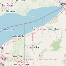
Use this park location map to pinpoint Allegheny National Recreation Area in United States of America, understand its exact geographic position, and read its mapped placement within the surrounding landscape more clearly.

Pigeon | © OpenStreetMap contributors

Location context for Allegheny National Recreation Area

Pennsylvania

Visual reference guide to plateau terrain, reservoir shorelines, and forest habitats

Allegheny National Recreation Area Photos and Protected Landscape Scenery

Visual documentation captures the rolling ridges, expansive reservoir coves, and dense hardwood forests that define the protected landscape of Allegheny National Recreation Area. Detailed photography provides a clear window into the river corridors, backcountry terrain, and upland habitats characteristic of northwestern Pennsylvania.

A simple wooden footbridge with a handrail spans a small, shallow stream in a wooded area, with fallen leaves covering the forest floor.

Park atlas

Compare surrounding regional geography and connected forest landscapes in Pennsylvania

Explore Other Parks and Protected Areas Near Allegheny National Recreation Area

Visitors exploring Allegheny National Recreation Area can browse adjacent protected landscapes and river corridors across the surrounding plateau. Continuing into nearby conservation areas reveals broader regional terrain patterns and connected forest ecosystems.
A pale, soft watercolor painting of a rolling landscape with green hills, scattered trees, and a flat foreground.
Protected landscapePennsylvania
About 0.5 km away#1 closest

Southwest

Allegheny National Forest: Geographic Analysis and Protected Landscape Mapping in Pennsylvania

Rolling plateau topography and expansive hardwood forest conservation zones.

Covering over half a million acres in northwestern Pennsylvania, Allegheny National Forest represents a pivotal protected landscape east of the Mississippi. This overview focuses on the intersection of even-aged timber management, old-growth hemlock stands, and the hydrology of the Allegheny Reservoir. Examine the forest's varied terrain, from ridgelines to riverine islands, through a lens of regional conservation and mapped environmental data.

Area
2,076.75 km²
Established
1923
Relief
Upland
Climate
Temperate
National parkOhio
About 211 km away#2 closest

West

Cuyahoga Valley National Park: Detailed Atlas and Protected Landscape Information

Explore the mapped geography and natural terrain of Ohio's National Park.

Access detailed atlas information for Cuyahoga Valley National Park, a vital protected landscape in Ohio. Understand its geographic scope, mapped boundaries, and the surrounding natural terrain. This entry provides essential context for exploring the park's identity as a National Park and its significance within the broader mapped geography of the United States.

Area
132.7 km²
Established
2000
IUCN
II
Visitors
2.9M annual
National parkOntario
About 237 km away#3 closest

North

Rouge National Urban Park: Ontario's Mapped Protected Landscape Atlas

Explore national park boundaries and regional geography.

Investigate Rouge National Urban Park, a designated national park situated in Ontario, Canada. This page provides detailed atlas-style information focusing on its mapped boundaries, regional geographic context, and its identity as a significant protected natural landscape. Understand the park's role within the broader Canadian atlas for landscape exploration.

Area
79.1 km²
Established
2015
IUCN
V
Relief
Mixed relief
Watercolor painting showing layers of soft green hills and mountain ridges fading into a light hazy background.
Protected landscapeWest Virginia
About 269 km away#4 closest

South

Monongahela National Forest: Protected Appalachian Landscapes and Regional Geography

Mapping West Virginia wilderness and mountain terrain

Monongahela National Forest protects nearly one million acres of the central Appalachian Mountains. This massive federally managed landscape is defined by the Allegheny Front, the highest peak in the Allegheny range at Spruce Knob, and iconic geological formations like Seneca Rocks. The region represents a vital intersection of climate, hydrology, and biodiversity in the eastern United States, housing eight distinct wilderness areas and complex high-altitude ecosystems.

Area
3,727.8 km²
Established
1920
Visitors
3M annual
Relief
Mountain
Marine protected areaNew York
About 279 km away#5 closest

Northeast

Lake Ontario National Marine Sanctuary: Geographic Atlas and Protected Area Overview

Mapping freshwater maritime heritage and coastal New York landscapes.

Spanning the southeastern waters of Lake Ontario, this marine protected area safeguards dozens of historic shipwrecks and vital Indigenous cultural sites. This atlas entry provides geographic context on the sanctuary boundaries, submerged archaeological zones, and the surrounding New York freshwater environment.

Area
4,460 km²
Established
2024
IUCN
V
Relief
Lowland
Wildlife reserveOntario
About 285 km away#6 closest

Northeast

Wellers Bay National Wildlife Area: Coastal and Island Geography in Ontario

An important Great Lakes barrier beach protected reserve

Wellers Bay National Wildlife Area contains a rare collection of undeveloped shorelines, including the Baldhead peninsula and offshore islands. This protected area offers a deep look into the littoral processes of Lake Ontario, providing crucial sanctuary for waterbirds and endangered species within a fragile, compact, and natural woodland environment.

Area
0.74 km²
Established
1978
IUCN
Ia
Scope
Terrestrial
A minimalist watercolor painting showing rolling green hills and a flat plateau with abstract vegetation against a white background.
Wildlife reserveWest Virginia
About 288 km away#7 closest

South

Dolly Sods Wilderness: Geography and Protected Landscape Analysis for West Virginia

High-altitude plateaus and sub-arctic Appalachian terrain.

Trace the boundaries and protected landscape of Dolly Sods Wilderness, a 17,000-acre wildlife reserve in West Virginia. This atlas-focused look highlights the area's geological elevation near 4,000 feet, its unique plant communities including sphagnum bogs, and the distinct role of its recovering ecosystems within the larger Monongahela National Forest.

Area
71.94 km²
Established
1975
IUCN
Ib
Visitors
7.5K annual
National parkOntario
About 290 km away#8 closest

West

Point Pelee National Park: Ontario's National Park Atlas and Protected Landscape Explorer

Mapped geography and protected area context within Ontario.

Point Pelee National Park is a designated national park in Ontario, Canada, offering a unique focus for geographic discovery. This entry details its protected landscape and mapped boundaries, essential for understanding its place within regional park atlases. Explore the core geographic identity of Point Pelee National Park and its significance as a protected natural area.

Area
15 km²
Established
1918
IUCN
II
Visitors
491.1K annual

Common questions about visiting, size, designation, and location context for Allegheny National Recreation Area

Allegheny National Recreation Area FAQs for park facts, access, geography, and protected area context

Find quick answers about Allegheny National Recreation Area, including protected-area facts, park geography, trail and visitor context, and how the park fits into its surrounding country and regional landscape.
MoriAtlas Explorer

Continue Your Protected Areas Search Across the Global Atlas

Deepen your exploration by continuing the structured search for national parks and protected areas worldwide. Utilize the comprehensive filtering capabilities to compare different conservation landscapes and refine your understanding of global park geography. Discover more about the distribution and characteristics of protected natural areas.

Global natural geography