

Mori Atlas logo
Nature reserveAlto Mayo Protection Forest

Understanding the hydrological geography and cloud forest terrain of this critical Peru reserve

Alto Mayo Protection Forest in San Martin: A Detailed Map of Andean Slope Protected Landscapes

(Bosque de Protección Alto Mayo)

Alto Mayo Protection Forest protects a essential stretch of Peruvian Yungas across the eastern Andean slopes of San Martin. This region acts as a vital watershed for the Mayo River, supporting diverse montane ecosystems and critical habitats for the rare yellow-tailed woolly monkey. Detailed mapping reveals a complex topography of steep ridges and deep valleys that bridge the gap between high altitude Andean highlands and the lowland Amazon basin.

peruvian yungascloud forestandean slopeprotected forestwatershedmayo river
Digital illustration of a valley between steep purple mountains, featuring a distant waterfall, palm trees in the foreground, and soft pastel clouds in the sky.

Alto Mayo Protection Forest

Nature reserve

Park overview

Structured park overview, official facts, and landscape profile for Alto Mayo Protection Forest

Alto Mayo Protection Forest park facts, protected area profile, and essential visitor context

Review the core facts for Alto Mayo Protection Forest, including designation, size, terrain, visitor scale, habitats, and operating context in one park-focused overview.

About Alto Mayo Protection Forest

The Alto Mayo Protection Forest occupies a dramatic position along the eastern flank of the Andes in northern Peru. The terrain is steep, mountainous, and heavily forested, with slope gradients in many places exceeding seventy percent. Rivers descending from these mountains carve deep valleys through forest that grades from cloud forest at higher elevations down toward the broader Amazon basin. The reserve sits at the heart of the upper Mayo River basin, capturing rainfall and feeding the tributaries that ultimately supply the Mayo valley with the water on which agriculture and rural communities depend.

Ecologically, Alto Mayo belongs to the Peruvian Yungas, a transitional ecoregion that links Andean montane habitats with lowland Amazonian forest. This gradient supports a rich mix of plant and animal life, from canopy trees such as cedro and tornillo to orchids long prized in the illegal wildlife trade. The reserve is also one of the last strongholds of the yellow-tailed woolly monkey, whose presence has come to define Alto Mayo's conservation identity.

The area protected today is the result of decades of evolving policy, research, and on-the-ground tension. Originally established as the Alto Mayo National Forest in 1963, the area lost effective protection during the 1970s and early 1980s as colonists moved in, forests were cleared for agriculture, and hunting reduced wildlife populations. The 1987 redesignation that created the present-day protection forest attempted to refocus on the upper watershed, where conservation value and hydrological importance intersected most clearly. Today, the reserve is a focal landscape for international conservation partnerships, REDD+ programs, and efforts to balance forest protection with the livelihoods of the people who live around it.

Quick facts and research context for Alto Mayo Protection Forest

Alto Mayo Protection Forest covers roughly 1,820 square kilometers of mountainous tropical forest along the upper Mayo River basin in northern Peru. It lies primarily in the Rioja and Moyobamba provinces of the San Martín region, with a small portion extending into Rodríguez de Mendoza province in Amazonas. The reserve is administered by SERNANP, Peru's national protected areas service, and is classified as IUCN Category VI, a protected area with sustainable use of natural resources.

Ecologically, the forest protects part of the Peruvian Yungas ecoregion, a steep and biodiverse transition zone between the Andes and the Amazon. It is a critical headwaters area for the Mayo River and supplies water to communities further down the valley. The park was formally protected in 1987, building on earlier protections dating back to 1963.

Protection and recognition

Examine documented protection scope and international recognition records

Alto Mayo Protection Forest Protection Status and Terrestrial Designation

Alto Mayo Protection Forest maintains a documented terrestrial protection status within official conservation inventories. Structured records outline management scope and international recognition details for this protected area.

Protection details

Protection scope
Terrestrial
Transboundary protection
No
Park context

Deeper park guide and search-rich context for Alto Mayo Protection Forest

Alto Mayo Protection Forest history, landscape, wildlife, and travel context

Explore Alto Mayo Protection Forest through its history, landscape character, ecosystems, wildlife, conservation priorities, cultural context, and seasonal travel timing in a structured park guide built for atlas discovery and search intent.

Why Alto Mayo Protection Forest stands out

Alto Mayo Protection Forest is best known for safeguarding the habitat of the yellow-tailed woolly monkey (Oreonax flavicauda), one of Peru's rarest primates and a flagship species for cloud forest conservation. The monkey's rediscovery in 1974 in nearby forest areas played a decisive role in building the scientific and political case for formally protecting Alto Mayo in 1987. The reserve is also recognized for its hydrological importance: its upper watershed feeds the Mayo River, which sustains agriculture, drinking water, and aquatic ecosystems across the Mayo valley. Beyond these focal points, the forest is valued as a stronghold of Peruvian Yungas biodiversity, a steep and species-rich Andean slope ecosystem where montane forest, cloud forest, and upper Amazonian habitats converge.
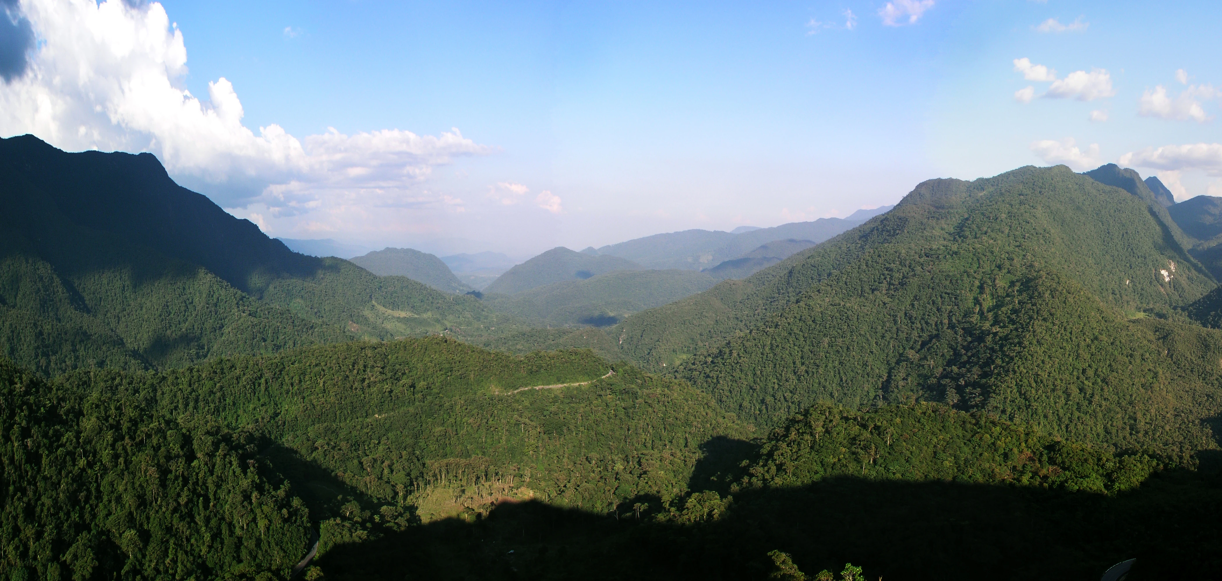
A wide panoramic view of lush, forested mountains under a blue sky with scattered white clouds, taken from a high vantage point.
A panoramic view of the Alto Mayo massif from the Abra Patricia pass, showcasing the dense tropical yungas forest landscape.

Alto Mayo Protection Forest history and protected-area timeline

Protection of the Alto Mayo landscape has a layered and at times turbulent history. In 1963, the Peruvian government granted protection over the area, declaring it the Alto Mayo National Forest by Law No. 442. For more than a decade afterward, the forest was treated primarily as a forestry resource, but the protections it carried were never meaningfully enforced.

The early 1970s brought rapid change. Colonists began moving into the area and clearing forest for agriculture, and road-building crews hunted wildlife, including the yellow-tailed woolly monkey, for food. The government responded by revising the original law and carving out agricultural zones, leaving only the higher forests of the upper valley under protection. In 1974, scientists rediscovered the yellow-tailed woolly monkey in nearby areas, and that finding helped spark a wave of research and conservation interest in the Alto Mayo forests.

Between 1974 and 1983, several research projects on local fauna and forest ecology reached the same conclusion: the area deserved strong conservation protections. A 1977 effort by the local Ministry of Agriculture office to define boundaries and a protection category for the forest was filed and forgotten. In 1979, the Carretera Marginal de la Selva, a major road linking the eastern forests with the Pacific coast, was opened, intensifying colonization pressure. A renewed push in 1984 led to formal protection of the forest by decree on July 23, 1987, creating the Alto Mayo Protection Forest in roughly its present form.

Alto Mayo Protection Forest landscape and geographic character

The landscape of Alto Mayo Protection Forest is defined by the steep eastern slopes of the Andes. The terrain rises and falls rapidly, with slope grades exceeding seventy percent in many locations, producing a mosaic of ridges, ravines, and narrow valleys. These slopes shed water through a dense network of streams that converge into the Mayo River system, and eleven of the Mayo's main tributaries originate within the protected area.

The reserve occupies the upper watershed of the Mayo basin, an ecologically and hydrologically critical position. Forest cover across these slopes slows runoff, regulates streamflow, and reduces erosion, while also trapping moisture in the form of cloud forest and humid montane habitats at higher elevations. As elevation drops toward the south and east, forests transition into the lower elevation formations of the broader Amazon basin.

The result is a physically varied and visually striking landscape of forested mountains, fast-flowing rivers, and deeply shaded valleys, where steep topography and continual moisture support one of the more biologically productive habitats in northern Peru.

Alto Mayo Protection Forest ecosystems, habitats, and plant life

The Alto Mayo Protection Forest protects a significant stretch of the Peruvian Yungas, the Andean-to-Amazon transition zone that is among the country's most ecologically distinctive ecoregions. The Yungas combines elements of premontane forest, lower montane forest, and cloud forest, creating conditions for high species turnover across relatively short elevational gradients.

Vegetation is correspondingly diverse. Canopy and emergent trees include commercially and culturally important species such as cedro, requia, rifari, ojé, cetico, uvilla, tornillo, cascarilla, palo seco, huamansamana, amasisa, quinilla, marupa, yurac ciprana, zapote, guayacán, catahua, mashonaste, and moena negra. The forest's understory and epiphytic layers host orchids such as Phragmipedium boisserianum and Masdevallia vargasii, which are part of the orchid diversity that has historically drawn both researchers and illegal collectors to the area.

Wet conditions combine with elevational variation to produce dense, layered forest on slopes that are difficult to access and historically difficult to clear. This landscape character, rather than any single species, is what defines Alto Mayo ecologically: a steep, humid, structurally complex forest that supports both high biodiversity and critical watershed functions.

Alto Mayo Protection Forest wildlife and species highlights

Wildlife is one of the principal reasons for Alto Mayo's protected status. The reserve is most closely associated with the yellow-tailed woolly monkey, a primate that survives only in a limited set of cloud forest patches across northern Peru. After being heavily hunted by road-building crews in the 1970s, the species became a focal point for conservation attention in the area, and its recovery prospects remain tied to the integrity of forests like Alto Mayo.

Other mammals documented in the forest include the spectacled bear, the cougar, the Peruvian night monkey, the Rio Mayo titi, and the giant armadillo. Together, they suggest a mammal community typical of well-forested Andean slopes, with both larger predators and smaller, often more range-restricted primates dependent on intact canopy.

Birdlife in the reserve is also notable. Recorded species include the Andean cock-of-the-rock, the oilbird, the king vulture, the equatorial greytail, the long-whiskered owlet, the swallow-tailed kite, the razor-billed curassow, the Andean guan, the speckled chachalaca, the blue-grey tanager, and the white-throated toucan. The presence of cave-breeding species such as the oilbird is consistent with the karst and cliff features found in parts of the Andean slope. Across both mammals and birds, the wildlife profile is one of intact forest indicators under increasing pressure from habitat loss and direct exploitation.

Alto Mayo Protection Forest conservation status and protection priorities

Alto Mayo Protection Forest matters from a conservation standpoint for at least three overlapping reasons: watershed protection, biodiversity preservation, and climate mitigation. Its upper basin position means the forest directly affects downstream water availability, sediment loads, and flood cycles for communities across the Mayo valley. Treating the forest as a water supply rather than purely as a biodiversity reserve has been central to its management rationale.

The area faces a familiar set of tropical-forest pressures. Illegal settlement and clearance for small-scale agriculture remains the most visually obvious threat, with forest gaps still expanding along advancing colonization fronts. Timber extraction, unsustainable fishing in the Mayo and its tributaries, and the illegal extraction of wild orchids and live animals for sale all add additional pressures. Deforestation within and around the reserve is a persistent concern, and the reserve's protected status has not eliminated the underlying drivers of forest loss.

In response, the protected area has been a focus for payments-for-conservation and climate finance mechanisms. Conservation agreements linked to voluntary-market REDD+ finance have been used as a forest-conservation and climate-mitigation tool within Alto Mayo, often in partnership with organizations such as Conservation International Peru. These efforts attempt to align the interests of local communities with the goal of keeping forest standing. Conservation outcomes in Alto Mayo ultimately hinge on whether these socioeconomic strategies can outcompete the economic pull of agricultural expansion in one of Peru's last major Andean forest frontiers.

Top sights and standout views in Alto Mayo Protection Forest

The strongest points of distinction for Alto Mayo Protection Forest are its combined ecological and hydrological significance. It shelters one of the last populations of the yellow-tailed woolly monkey in a landscape that has been progressively fragmented by colonization, while at the same time anchoring the water supply for the Mayo valley. Few protected areas in Peru carry that dual load as visibly.

The reserve is also notable as a laboratory for forest conservation finance. Its landscape has been a focal area for REDD+ initiatives and conservation agreements that link climate mitigation funding to local stewardship, often with international conservation partners. The terrain itself, steep, forested, and difficult to access, has shaped both the patterns of colonization and the patterns of protection that define the area today.

Best time to visit Alto Mayo Protection Forest

Given the tropical, humid character of the Andean slope forest, visits to Alto Mayo are generally most comfortable during the drier months, when rainfall and humidity are lower and trails, roads, and forest visibility improve. The reserve's elevation range produces cooler nights and a wider diurnal temperature swing than lowland Amazon sites.

The wetter months bring heavier rains, denser leeches, and more challenging forest conditions, but they are also when rivers are fullest and fruiting trees support richer wildlife activity. Birdwatching and primate observation are typically more rewarding when canopy trees are producing fruit or flowers, while clearer skies during drier periods favor scenic views across the steep Mayo valley. Because conditions vary with elevation, planning a visit around the driest part of the regional cycle tends to produce the most straightforward experience.

Monthly climate preview

Long term temperature and precipitation records measured at representative park coordinates

Alto Mayo Protection Forest Climate Normals and Annual Weather Patterns

Representative coordinates document sustained monthly averages ranging from nineteen to twenty one degrees Celsius alongside shifting precipitation rates. Examining the full twelve month profile reveals detailed temperature ranges and monthly rainfall trends for this conservation area.
Annual mean20 °C
20 °C21 °C
Jan20°
Feb20°
Mar20°
Apr20°
May20°
Jun20°
Jul20°
Aug21°
Sep21°
Oct21°
Nov21°
Dec21°
Warmest month
September

21.3 °C

Coolest month
June

19.5 °C

Wettest month
March

3.5 mm/day

Driest month
August

0.9 mm/day

Park location guide

Geography guide, regional context, and park location map for Alto Mayo Protection Forest

Alto Mayo Protection Forest park geography, regions, and map view in Peru

Understand where Alto Mayo Protection Forest sits in Peru through a broader geographic reading of the surrounding landscape, nearby location context, and its mapped position within the national park landscape.

How Alto Mayo Protection Forest fits into Peru

Peru is a megadiverse country in western South America with a population of over 34 million. It spans three distinct geographic regions: the Pacific coastal desert in the west, the Andes mountains running north to south, and the Amazon rainforest in the east. The country has one of the longest histories of civilization in the world, tracing back to the Caral-Supe civilization of the 10th millennium BCE, and was home to the Inca Empire before Spanish colonization in the 16th century.

Wider geography shaping Alto Mayo Protection Forest in Peru

Peru is located in western South America along the Pacific coast. The country encompasses three major geographic regions: the coastal desert plains along the Pacific, the Andes mountain range extending from north to southeast, and the Amazon basin rainforest in the eastern interior. It shares borders with Ecuador and Colombia to the north, Brazil to the east, Bolivia to the southeast, and Chile to the south.

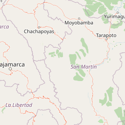
Map view of Alto Mayo Protection Forest

Use this park location map to pinpoint Alto Mayo Protection Forest in Peru, understand its exact geographic position, and read its mapped placement within the surrounding landscape more clearly.

Pigeon | © OpenStreetMap contributors

Location context for Alto Mayo Protection Forest

AmazonasSan Martin
Recorded earthquake history

Review the Recorded Seismic History of the Alto Mayo Protection Forest

Gain insight into the seismic background of the region by examining a curated catalogue of recorded earthquakes. Access detailed event data associated with the geography of the Alto Mayo Protection Forest, managed as part of the MoriAtlas geographic database.

Alto Mayo Protection Forest Earthquakes

Catalogued events

162 events

Strongest magnitude

Magnitude 7.1

Most recent event

Apr 16, 2026

This history includes earthquakes recorded inside the park or within 50 km of its borders

Visualizing the steep Andean slopes, cloud forests, and protected watersheds of northern Peru

Alto Mayo Protection Forest Photos and Landscape Scenery

Visual records capture the rugged terrain, dense cloud forests, and steep Andean slopes that define the reserve. Examining these protected habitats clarifies the complex topography and environmental character of the upper Mayo River watershed.

A wide panoramic view of lush, forested mountains under a blue sky with scattered white clouds, taken from a high vantage point.

An aerial view showing green tropical forest covering mountain slopes with a clearing or pasture visible in the midground.

Park atlas

Compare regional biodiversity, steep Andean slopes, and connected forest reserves

Explore Parks Near Alto Mayo Protection Forest and Surrounding Protected Landscapes

Browse protected areas and national parks near Alto Mayo Protection Forest to examine regional Andean slope ecosystems and tropical forest corridors. Comparing adjacent reserves reveals broader ecological patterns across the northern Peruvian mountain frontier.
Wildlife reserveAmazonas Region
43 km away#1 closest

West

Chayu Nain Communal Reserve: Mapped Protected Landscapes and Regional Geography in Peru

Andes to Amazon ecological transition zone in the Amazonas region

Chayu Nain Communal Reserve functions as a critical stronghold for endemic wildlife and represents a major achievement in communal conservation. Its sandstone geology and elevational gradients create a distinct terrain that sustains rare primate populations, lowland tapirs, and complex forest mosaic habitats in northern Peru.

Area
235.98 km²
Established
2009
IUCN
VI
Relief
Upland
National parkCajamarca Region
114 km away#2 closest

Southwest

Cutervo National Park: Peru's Oldest National Park Atlas and Protected Landscape

Andean Montane Forests and Mapped Geography of a Pioneering Protected Area

As Peru's oldest national park, established in 1961, Cutervo National Park offers a unique glimpse into the protected geography of the northern Peruvian Andes. Located in the Cajamarca Region, it preserves diverse Andean montane forests and páramo grasslands across a significant elevation gradient from 1,550 to 3,500 meters. This page details the park's landscape, including its role as a headwater conservation area and its position within a critical South American ecoregion, providing rich context for geographic and protected-area exploration.

Area
82.14 km²
Established
1961
IUCN
II
Relief
Mountain
National parkSan Martín Region
135 km away#3 closest

South

Rio Abiseo National Park: Peru's Protected Landscape Identity and Geographic Context

Discover the mapped boundaries and regional atlas information.

Investigate Rio Abiseo National Park, a designated national park situated within the San Martín Region of Peru. This detailed entry focuses on its protected landscape characteristics and its specific geographic placement. Understand the park's mapped boundaries and its role in the broader atlas of protected areas, offering a structured approach to geographic discovery.

Area
2,745.2 km²
Established
1983
IUCN
II
Relief
Mountain
Nature reserveZamora Chinchipe
136 km away#4 closest

Northwest

Reserva Biológica Cerro Plateado: Andean and Amazonian Landscape and Protected Area Context

Vertical gradient and mountain forest geography in Zamora Chinchipe

Spanning elevations from 840 to 3,120 meters, Reserva Biológica Cerro Plateado represents a significant conservation effort within the Zamora Chinchipe province. The reserve preserves intact montane cloud forests and paramo, serving as a vital link between the eastern Andean slopes and the Nangaritza watershed in southeastern Ecuador.

Area
307.607 km²
Established
2010
IUCN
Ia
Relief
Mountain
National parkPeru
143 km away#5 closest

Southeast

Cordillera Azul National Park: A National Park for Geographic Discovery in Peru

Explore Peru's protected landscape and regional map context.

Cordillera Azul National Park serves as a dedicated entry point for understanding Peru's protected natural areas through a geographic lens. This park's identity is tied to its specific mapped boundaries and its contribution to the nation's diverse terrain. Focusing on Cordillera Azul National Park allows for detailed atlas exploration of its unique landscape context within western South America, providing factual data for geographic understanding.

Area
13,531.9 km²
Established
2001
IUCN
II
Relief
Mountain
Protected areaCajamarca Region
155 km away#6 closest

Southwest

Pagaibamba Protection Forest: Geography and Protected Area Landscape Analysis

Highland Watershed Protection in the Cajamarca Andes

Pagaibamba Protection Forest represents a key protected land entity in northern Peru. Focused on maintaining the local water cycle, the area showcases dense cloud forest vegetation and steep Andean terrain. Use this mapping data to analyze its ecological boundaries, watershed significance, and regional landscape context in the Cajamarca department.

Area
20.784 km²
Established
1987
IUCN
VI
Relief
Mountain
National parkEcuador
162 km away#7 closest

Northwest

Podocarpus National Park: Ecuador's Diverse National Park and Protected Landscape

Discover elfin forests, paramo, and over 100 lagoons.

Podocarpus National Park, situated in southeastern Ecuador, stands as a prime example of a protected natural area at a unique biogeographic crossroads. This national park spans dramatic elevational zones, from montane rain forests to high-elevation paramo ecosystems dotted with more than 100 lagoons, offering rich mapped landscape exploration. Its significance lies in the convergence of four distinct ecological systems, contributing to exceptional biodiversity and a rich tapestry of natural terrain.

Area
1,462.8 km²
Established
1982
IUCN
II
Relief
Mountain
Wildlife reserveCajamarca Region
162 km away#8 closest

Southwest

Sunchubamba Game Reserve: Geographic Overview of Protected Andean Landscapes in Northern Peru

Examining dry forest ecosystems and managed habitat in the Cajamarca Region

Explore the unique environmental footprint of Sunchubamba Game Reserve, a protected area in northern Peru characterized by its blend of native dry forests and non-native tree plantations. This record details the reserve as a historical hacienda site that now serves as an important study in land-use, wildlife management, and the evolution of Andean highland conservation practices.

Area
597.35 km²
Established
1977
IUCN
VI
Relief
Mountain

Common questions about visiting, size, designation, and location context for Alto Mayo Protection Forest

Alto Mayo Protection Forest FAQs for park facts, access, geography, and protected area context

Find quick answers about Alto Mayo Protection Forest, including protected-area facts, park geography, trail and visitor context, and how the park fits into its surrounding country and regional landscape.
MoriAtlas Explorer

Continue Your Protected Areas Search Across the Global Atlas

Deepen your exploration by continuing the structured search for national parks and protected areas worldwide. Utilize the comprehensive filtering capabilities to compare different conservation landscapes and refine your understanding of global park geography. Discover more about the distribution and characteristics of protected natural areas.

Global natural geography