
Mori Atlas logo
Nature reserveAm Pfingsthut

Examining the geographic boundaries and ecological mosaic of this historic German woodland reserve.

Am Pfingsthut Nature Reserve: Mapped Protected Forest Landscapes in Southern Thuringia

(Naturschutzgebiet Am Pfingsthut)

Am Pfingsthut is a protected nature reserve in the Landkreis Hildburghausen region of southern Thuringia. This forested habitat, designated for conservation in 1967, serves as an essential link within a broader network of protected sites between Westhausen and Gellershausen. The landscape context reflects a gentle rural mosaic where woodland patches contrast with surrounding agricultural meadows and traditional village settings.

nature reserveThuringiawoodland habitatprotected forestsmall reserveIUCN Category IV
A flat-style digital illustration of a mountain valley with steep cliffs, a waterfall, a river, and a pine forest under a clear sky.

Am Pfingsthut

Nature reserve

Park overview

Structured park overview, official facts, and landscape profile for Am Pfingsthut

Am Pfingsthut park facts, protected area profile, and essential visitor context

Review the core facts for Am Pfingsthut, including designation, size, terrain, visitor scale, habitats, and operating context in one park-focused overview.

About Am Pfingsthut

Am Pfingsthut is a nature reserve in the German federal state of Thuringia, located in the Landkreis Hildburghausen in the southern part of the state. The reserve sits in a rural, historically agricultural landscape close to the Inner German border region, where many small protected areas were established over the decades to conserve woodland, meadow, and other semi-natural habitats that developed with limited human intervention.

Geographically, the area lies between the main village of Westhausen, to the northwest, and Gellershausen, a district of the town of Heldburg, to the southeast. Two state roads frame the site: the L 2671 to the west and the L 1134 to the east. This positioning at the edge of small rural communities gives the reserve a quiet, peripheral character within the broader countryside, making it part of the working agricultural landscape rather than a remote wilderness.

The reserve was placed under nature protection in 1967 under the identifier 135. Its purpose is the long-term conservation of its forested habitat. It is one of around two dozen nature reserves in the Landkreis Hildburghausen, a district that includes contrasting sites such as the Gleichberge hill reserve, the Rodachtal valley, and the Schlechtsarter Schweiz. Together, these sites reflect the district's diversity of geomorphology, ranging from lowland forests and meadows to hill-country slopes.

Internationally, Am Pfingsthut is classified as an IUCN Category IV area, indicating a Habitat or Species Management Area, a designation that reflects active habitat preservation rather than strict wilderness protection. Its inclusion in the World Database on Protected Areas confirms its standing as a formally recognized conservation site.

While the reserve is small, roughly 33 hectares, its position within a wider ecological network is what gives it value. To the southwest lies the Lachenwäldchen reserve, and to the northeast stretches the larger Grabfeld meadow complex, a designated FFH (Fauna-Flora-Habitat) area of around 332 hectares. These adjacent sites together sustain continuous forest-meadow transitions that support biodiversity across a regional landscape scale.

Quick facts and research context for Am Pfingsthut

Am Pfingsthut is a designated nature reserve in Thuringia, Germany, located in the Landkreis Hildburghausen. It covers approximately 33.4 hectares and was placed under nature protection in 1967. The reserve carries the official identifier 135 and is recorded in the World Database on Protected Areas under WDPA-ID 162177. It is set in a rural landscape between the villages of Westhausen and Gellershausen, and is bordered by state roads and neighboring protected areas.

Protection and recognition

Examining the documented conservation framework and recognition history

Am Pfingsthut Protection Status and Official Designation Records

Am Pfingsthut maintains structured protection records that outline its established conservation boundaries and administrative context. Official database entries provide verifiable reference details regarding regional protected area status.

Protection details

WDPA ID
162177
Park context

Deeper park guide and search-rich context for Am Pfingsthut

Am Pfingsthut history, landscape, wildlife, and travel context

Explore Am Pfingsthut through its history, landscape character, ecosystems, wildlife, conservation priorities, cultural context, and seasonal travel timing in a structured park guide built for atlas discovery and search intent.

Why Am Pfingsthut stands out

Am Pfingsthut is primarily known as a small woodland nature reserve established in 1967 in the southern Thuringian district of Hildburghausen. Its significance lies in its role within a network of nearby protected sites, including the Lachenwäldchen forest reserve to the southwest and the larger Grabfeld meadow FFH area to the northeast.
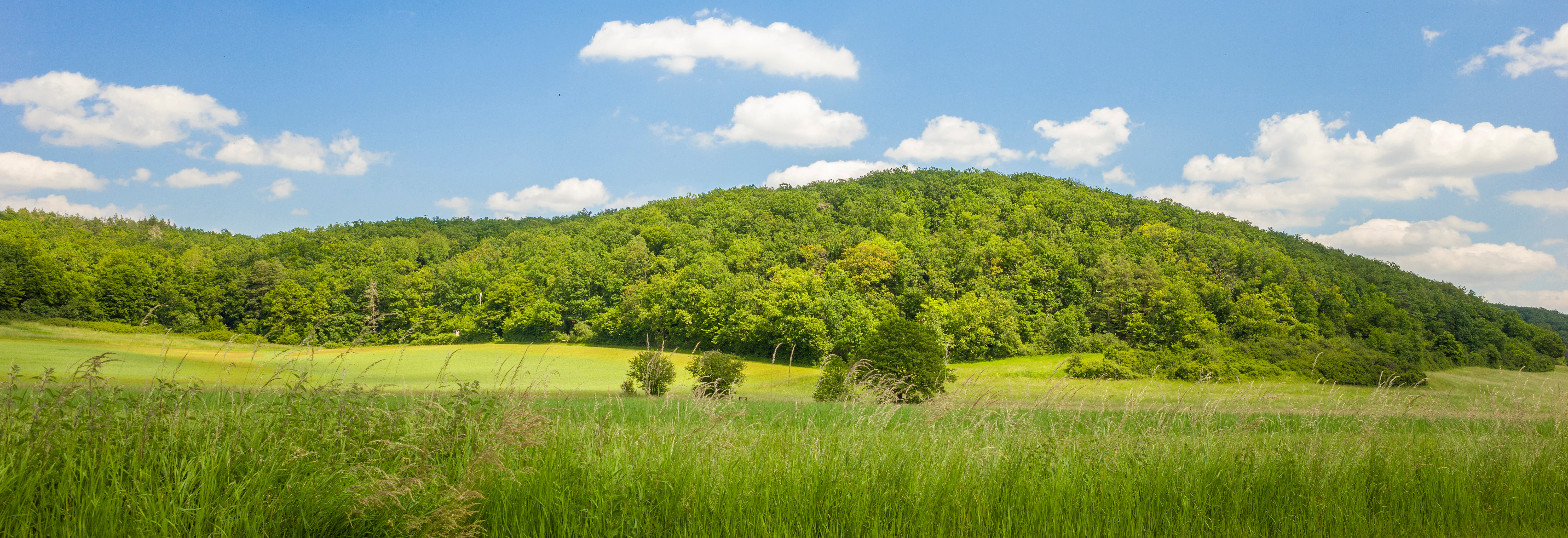
A wide view of a green, forest-covered hill rising above a grassy meadow under a blue sky with scattered clouds.
View of the forested landscape of Am Pfingsthut nature reserve.

Am Pfingsthut history and protected-area timeline

Am Pfingsthut was formally designated as a nature reserve (Naturschutzgebiet) in 1967, with the official identifier 135. The reserve is one of several protected sites in the Landkreis Hildburghausen established during the mid-twentieth century, a period when many local reserves in Thuringia were first formally protected in response to growing recognition of the ecological value of small rural habitats. Its continued listing in the World Database on Protected Areas reflects its unbroken status as a recognized conservation site.

Am Pfingsthut landscape and geographic character

The landscape around Am Pfingsthut is gently undulating rural country typical of southern Thuringia. The reserve itself appears to be a forested patch within a mosaic of farmland, small villages, and connecting roads. Its position between Westhausen and Gellershausen places it in a transition between settlement areas and the surrounding agricultural countryside.

To the west, the state road L 2671 and to the east, the L 1134 form clear boundaries along the reserve. To the northeast lies the larger open landscape of the Grabfeld meadows, a habitat that contrasts with the wooded interior of Am Pfingsthut, while to the southwest, the Lachenwäldchen reserve extends a connected forested character. The visual character of the area is shaped by this mixing of woodland edge with open meadows and traditional village surroundings.

Am Pfingsthut ecosystems, habitats, and plant life

Am Pfingsthut protects a forested habitat of roughly 33 hectares within a wider agricultural setting. The reserve's ecological value is closely tied to its position adjacent to the Grabfeld meadow FFH area, which sustains open grassland and meadow habitats. The reserve is part of a regional ecological network that combines woodland patches, such as Lachenwäldchen, with larger meadow systems, providing ecological continuity for forest-dependent species and those that use the forest-meadow boundary.

Am Pfingsthut wildlife and species highlights

The Wikipedia source does not provide specific information about individual species occurring in the reserve. As a small woodland habitat adjacent to extensive meadows, Am Pfingsthut is part of a landscape mosaic that typically supports typical central German woodland fauna, including small mammals, woodland birds, and insect communities associated with mature and semi-mature mixed forest stands.

Am Pfingsthut conservation status and protection priorities

Am Pfingsthut has formal protection as a Naturschutzgebiet under Thuringian nature conservation law, placing it under the highest level of habitat protection available under German state law for sites of this kind. Its IUCN Category IV designation reflects its function as a habitat and species management area, prioritizing the maintenance of specific habitat conditions rather than wilderness preservation.

Am Pfingsthut cultural meaning and human context

The reserve sits in a region shaped by centuries of small-scale farming, village settlement, and the proximity of the former Inner German border. Many nature reserves in this part of Thuringia, including those in the Landkreis Hildburghausen, were established in part to protect habitats that had developed along the restricted border zone, where conventional agriculture was limited for decades. Today, the reserve is part of a rural cultural landscape defined by traditional villages such as Westhausen and Heldburg.

Top sights and standout views in Am Pfingsthut

Am Pfingsthut is a compact, formally protected forest reserve in southern Thuringia with over fifty years of conservation history since its 1967 designation. Its location among a network of neighboring protected sites, including the Lachenwäldchen forest and the broader Grabfeld meadow FFH area, gives it regional ecological relevance despite its small individual footprint.

Best time to visit Am Pfingsthut

As a small nature reserve without extensive visitor infrastructure, Am Pfingsthut is best appreciated in spring and early summer, when deciduous woodland is fully leafed and conditions for walking in the surrounding rural landscape are most comfortable. Late spring also offers the best contrast with the open meadows of the neighboring Grabfeld area to the northeast.


Monthly climate preview

Long-term monthly temperature and precipitation rhythm for Am Pfingsthut in Thuringia

Am Pfingsthut Climate Normals and Annual Temperature Patterns

Representative coordinate records show average monthly temperatures ranging from sub-zero winter minimums to warm summer peaks alongside steady year-round precipitation. Examining the complete twelve-month dataset reveals the full range of historical climate conditions measured at this elevation.
Annual mean8 °C
-2 °C18 °C
Jan-2°
Feb-1°
Mar
Apr
May12°
Jun16°
Jul18°
Aug18°
Sep13°
Oct
Nov
Dec-1°
Warmest month
July

18.2 °C

Coolest month
January

-1.8 °C

Wettest month
July

2.6 mm/day

Driest month
April

1.4 mm/day

Park location guide

Geography guide, regional context, and park location map for Am Pfingsthut

Am Pfingsthut park geography, regions, and map view in Germany

Understand where Am Pfingsthut sits in Germany through a broader geographic reading of the surrounding landscape, nearby location context, and its mapped position within the national park landscape.

How Am Pfingsthut fits into Germany

Germany is a federal republic in Western and Central Europe with a population of over 83 million across sixteen constituent states. It is Europe's largest economy by nominal GDP and a major global exporter and importer. The capital is Berlin, and the country borders Denmark, Poland, Czech Republic, Austria, Switzerland, France, Luxembourg, Belgium, and the Netherlands.

Wider geography shaping Am Pfingsthut in Germany

Germany is located in Western and Central Europe, spanning 357,022 km². It borders Denmark to the north, Poland and the Czech Republic to the east, Austria and Switzerland to the south, and France, Luxembourg, Belgium, and the Netherlands to the west. The country has coastlines on the Baltic Sea and North Sea to the north, with the Alps located in the southern region.

Map view of Am Pfingsthut

Use this park location map to pinpoint Am Pfingsthut in Germany, understand its exact geographic position, and read its mapped placement within the surrounding landscape more clearly.

Pigeon | © OpenStreetMap contributors

Location context for Am Pfingsthut

Thuringia

Explore detailed visual records of woodland habitats, terrain features, and regional nature reserve characteristics.

Am Pfingsthut Photos and Landscape Scenery: Visualizing the Protected Forest Reserve

Visual records capture the distinctive woodland canopy, undergrowth structures, and rural edges that define the protected environment of Am Pfingsthut. Examining photographic evidence reveals how local forest patches integrate with surrounding agricultural fields and neighboring conservation zones in southern Thuringia.

A wide view of a green, forest-covered hill rising above a grassy meadow under a blue sky with scattered clouds.

Park atlas

Discover adjacent woodland reserves and regional conservation landscapes in southern Thuringia

Explore Parks Near Am Pfingsthut and Surrounding Protected Natural Areas

Visitors exploring Am Pfingsthut can continue browsing nearby protected areas and connected forest habitats across the Hildburghausen district. Regional park comparison reveals the wider ecological mosaic of woodland patches and meadow reserves shaping the local terrain.
A wide watercolor illustration showing a green meadow with purple wildflowers in the foreground, green trees in the midground, and a soft pink and yellow sky.
Nature reserveThuringia
About 3 km away#1 closest

Southwest

Lachenwäldchen Nature Reserve: Protected Woodland Geography in Southern Thuringia

Mapping forest habitats and biodiversity in the Hildburghausen district

Lachenwäldchen is a 45.8 hectare nature reserve in Thuringia, Germany, providing a stable forest microclimate for saproxylic insects and beetle species. Its position within the rural landscape near Heldburg showcases the significance of compact, preserved woodland patches for regional conservation efforts and ecological connectivity in southern Germany.

Area
0.458 km²
Established
1961
IUCN
IV
Relief
Upland
Nature reserveThuringia
About 13 km away#2 closest

North

Werra bis Treffurt mit Zuflüssen: Protected River and Floodplain Network in Thuringia

Mapping an extensive 191 kilometer Natura 2000 river corridor.

The Werra bis Treffurt mit Zuflüssen protected area serves as a vital ecological corridor in Thuringia. This site encompasses a complex mosaic of fast-flowing highland brooks, expansive floodplain meadows, inland salt sites, and rare dissolution lakes. Its geography bridges high-altitude source regions with lower river valleys, creating a distinctive landscape transect that supports essential freshwater habitats and rare aquatic species across the state.

Area
22.6 km²
Established
2008
IUCN
IV
Relief
Mixed relief
A soft watercolor painting of a winding river flowing through green rolling hills and meadows under a hazy, bright sky.
Protected landscapeBavaria
About 33 km away#3 closest

Southeast

Naturpark Fränkische Schweiz, Frankenjura: An Atlas of Bavarian Karst and Forested Landscapes

Protected landscape geography within the northern Franconian Jura.

Naturpark Fränkische Schweiz, Frankenjura is a landmark protected area covering over 2,300 square kilometers across Bavaria. Its terrain is defined by a rhythmic sequence of limestone plateaux, winding river valleys, and dolomite formations, balanced by the quieter, pine-dominated reaches of the Veldensteiner Forst. This atlas entry details the park's geological complexity and its significant role in regional conservation.

Area
2,335.44 km²
Established
1968
Relief
Upland
Climate
Temperate
A horizontal watercolor painting showing soft, light-colored rolling hills and distant mountain ridgelines, with clusters of green trees in the foreground.
Nature reserveBavaria
About 36 km away#4 closest

Southeast

Naturwald Vierzehnheiligen Protected Area and Bavarian Forest Geography

Nature reserve featuring old-growth deciduous stands and limestone slope terrain

Naturwald Vierzehnheiligen comprises a vast, strictly protected forest in Upper Franconia, Germany. Spanning the foothills of the northern Franconian Jura, this reserve is defined by its structurally diverse canopy, moist ravine habitats, and limestone geological formations. It provides a essential study in non-intervention woodland management, serving as a critical refuge for broadleaved-forest species within the regional Bavarian landscape.

Area
5.413 km²
Established
2020
Relief
Upland
Climate
Temperate
Protected landscapeBavaria
About 36 km away#5 closest

East

Naturpark Frankenwald: Geographic Profile of Bavaria's Forested Protected Landscape

A vast, interconnected upland spanning the Bavaria and Thuringia border

Naturpark Frankenwald functions as a large-scale managed nature preserve that integrates cultural heritage with ecological conservation. The terrain consists of gentle mountainous ridges, narrow river valleys, and extensive mixed forests that form a continuous landscape belt across northern Bavaria. This profile provides an overview of the regional geography, boundary extent, and the natural features that define this significant central German upland area.

Area
1,023 km²
Established
1973
Relief
Upland
Climate
Temperate
A soft watercolor painting of a rolling forested landscape with green hills and trees on a white background.
Nature reserveBayern
About 41 km away#6 closest

South

Naturwald Knetzberge-Böhlgrund Nature Reserve and Steigerwald Forest Geography

A mapped overview of protected broadleaf forests in Lower Franconia.

Spanning over 800 hectares, Naturwald Knetzberge-Böhlgrund is a major protected forest entity in the Steigerwald that integrates mature stands, deadwood habitats, and steep valley topographies. This area offers a unique perspective on natural forest succession and ecological preservation within the German landscape, marked by its distinct sandstone ridges and high biodiversity.

Area
8.474 km²
Established
2020
Relief
Mountain
Climate
Temperate
A soft watercolor illustration of a bog landscape featuring layers of green coniferous trees, a flat horizon, and distant, faint pink hills against a white background.
Nature reserveThuringia
About 43 km away#7 closest

North

Schützenbergmoor Nature Reserve: Highland Bog Landscape in Thuringia, Germany

Examining protected wetland terrain and bog ecology

Schützenbergmoor is an essential protected area for understanding highland raised bog ecosystems in the Thuringian Forest. This small, high-altitude site illustrates the intersection of peatland formation and cool, moist regional geography, offering a window into the specialized wetland terrain and microclimates that define this protected landscape in central Germany.

Area
0.052 km²
Established
1967
Relief
Upland
Climate
Temperate
A horizontal watercolor painting showing a soft, natural landscape with rolling hills in the background, a line of trees in the midground, and a meadow with light wildflowers in the foreground.
Nature reserveSchweinfurt
About 44 km away#8 closest

Southwest

Saumain in der Stadt Schweinfurt Nature Reserve: Protected Main River Floodplain Geography

A vital riverine nature reserve in Schweinfurt, Bavaria

Spanning over 11 hectares within the city limits of Schweinfurt, this nature reserve protects an isolated, stable arm of the River Main. The area functions as a critical riparian habitat, featuring still water zones, emergent reeds, and hardwood floodplains that provide essential refuge in an urbanized region of Lower Franconia. Explore the geographic footprint of this protected site within the context of the greater Maintal landscape.

Area
0.116 km²
Established
1993
Relief
Lowland
Climate
Temperate

Common questions about visiting, size, designation, and location context for Am Pfingsthut

Am Pfingsthut FAQs for park facts, access, geography, and protected area context

Find quick answers about Am Pfingsthut, including protected-area facts, park geography, trail and visitor context, and how the park fits into its surrounding country and regional landscape.
MoriAtlas Explorer

Continue Your Protected Areas Search Across the Global Atlas

Deepen your exploration by continuing the structured search for national parks and protected areas worldwide. Utilize the comprehensive filtering capabilities to compare different conservation landscapes and refine your understanding of global park geography. Discover more about the distribution and characteristics of protected natural areas.

Global natural geography