

Mori Atlas logo
National parkParque nacional Antisana

A critical high-altitude corridor spanning glacial peaks, páramo wetlands, and diverse Andean forests

Parque nacional Antisana: Mapping the Volcanic Terrain and Andean Protected Landscapes

(Parque Nacional Antisana)

Parque nacional Antisana serves as a vital protected area within the Ecuadorian Andes, showcasing a remarkable altitudinal gradient that extends from the permanent ice of its namesake stratovolcano down to lush cloud forests. This landscape manages complex water-producing ecosystems, including expansive wetlands and high páramo plains that support a unique assembly of Andean wildlife. By tracing the park boundaries, observers gain insight into how these mountain terrains and hydrological watersheds sustain regional ecology and connectivity.

Andespáramoglacierstratovolcanocloud forestmontane forest
A flat-style digital illustration of a prominent, snow-covered volcanic peak centered in the distance, set above a river valley with rolling green hills, trees, and layered cliffs under a soft-colored sky with a simple sun.

Parque nacional Antisana

National park

Park overview

Structured park overview, official facts, and landscape profile for Antisana National Park

Antisana National Park park facts, protected area profile, and essential visitor context

Review the core facts for Antisana National Park, including designation, size, terrain, visitor scale, habitats, and operating context in one park-focused overview.

About Antisana National Park

Antisana National Park is a large protected area in northern Ecuador that captures a vertical slice of the Andes, from the ice fields high on Volcán Antisana down to the warm, forested eastern foothills. It lies on the Cordillera Real, between the highland province of Pichincha and the Amazon-side province of Napo, and includes parts of Quijos, Archidona, and Cayambe cantons. With an area exceeding 120,000 hectares, the park ranks among the most extensive protected landscapes in the country.

Its defining feature is the altitudinal transition that occurs within a relatively compact geographic footprint. Above roughly 4,500 meters, lichen and moss communities cling to the volcanic substrate near the glaciers. Below that, the páramo dominates, an open landscape of tussock grasses, cushion plants, and shrubs adapted to cold nights, strong winds, and intense sunlight. As elevation drops toward the east, the páramo gives way to cloud forests draped in mosses and epiphytes, then to montane evergreen forests that extend down toward the Amazon basin. This gradient gives the park exceptional ecological diversity.

The park also plays a central role in regional water security. The wetlands, soils, and vegetation of the Antisana páramo act as natural sponges, regulating the flow of water that ultimately reaches Quito and other populated areas. Conservation efforts within the park therefore extend beyond wildlife protection to encompass watershed management, making Antisana a key element of Ecuador's environmental infrastructure.

Antisana connects with other major protected areas, including Cayambe-Coca National Park to the north, Sumaco Napo-Galeras National Park to the northwest, and the Colonso Chalupas Biological Reserve to the south. Together these reserves form a continuous mosaic of habitats that supports wide-ranging species such as the Andean bear and the mountain tapir. Around the park, traditional haciendas and small agricultural and livestock properties reflect the long coexistence of human activity and Andean landscapes.

Quick facts and research context for Antisana National Park

Antisana National Park lies on the eastern Andean cordillera of Ecuador, spanning parts of Napo and Pichincha provinces, with the nearest major city being Quito. The park covers more than 120,000 hectares and includes ecosystems ranging from glacial zones on Volcán Antisana down through high páramo, cloud forest, and lower montane evergreen forest.

Originally created in 1993 as the Antisana Ecological Reserve, the area was redesignated as a national park in 2021. It is administered under Ecuador's national protected areas system with a strict conservation focus, particularly on high-altitude wetlands and the headwaters of rivers that supply water to Quito and nearby towns.

Protection and recognition

Documented terrestrial protection scope, establishment year, and management framework

Parque nacional Antisana Protection Status and Designation History

Terrestrial protection status for Parque nacional Antisana establishes its formal conservation framework following establishment in 2021. Structured records outline the official designation history and management scope associated with the protected area.

Protection details

Protection scope
Terrestrial
Designated year
2021
Transboundary protection
No
Park context

Deeper park guide and search-rich context for Antisana National Park

Antisana National Park history, landscape, wildlife, and travel context

Explore Antisana National Park through its history, landscape character, ecosystems, wildlife, conservation priorities, cultural context, and seasonal travel timing in a structured park guide built for atlas discovery and search intent.

Why Antisana National Park stands out

Antisana National Park is best known for its dramatic altitudinal range, from the glacier-capped summit of Volcán Antisana down through vast páramo plains, deep cliffs, and forested eastern slopes. The park is particularly celebrated as one of Ecuador's most important strongholds for the Andean condor, with towering rock faces such as the El Isco cliffs providing critical nesting and roosting habitat. It is also recognized for its water-producing landscapes: the wetlands and páramo of Antisana capture and release moisture that feeds the rivers supplying Quito and many communities in Napo and Pichincha. The combination of glacial scenery, open páramo, and rich Andean wildlife defines the park's identity.
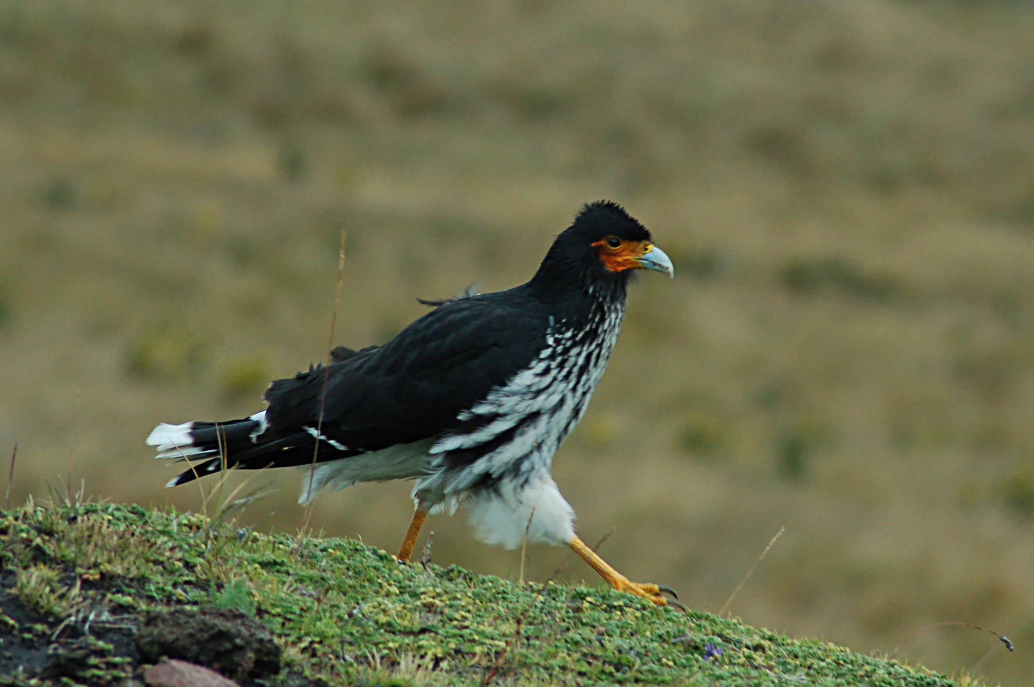
A medium shot of a Carunculated Caracara standing on a grassy, moss-covered ridge in a high-altitude Andean landscape.
A Carunculated Caracara perched on a mossy Andean slope in Antisana National Park.

Antisana National Park history and protected-area timeline

Antisana's formal protection began on 21 July 1993, when the Ecuadorian state established the area as the Reserva Ecológica Antisana through Interministerial Agreement No. 0018, published in the Official Register on 31 August 1993. The reserve was created with a strong emphasis on biodiversity conservation and the protection of high-altitude wetlands and water sources.

In July 2021, Ministerial Agreement No. 20 of 20 July 2021 reclassified the area, elevating it from an ecological reserve to a national park, under the new official name of Parque Nacional Antisana. This change reflected the park's growing recognition as a high-priority conservation landscape and reinforced its protected status within Ecuador's national system.

Alongside governmental management, the Fundación Antisana has played an important role in the reserve's development, supporting research, conservation programs, and social initiatives in surrounding communities. Projects in the buffer zone include trout farming around Papallacta and Cosanga and organic hydroponic agriculture, both designed as sustainable alternatives to traditional land-use practices.

Antisana National Park landscape and geographic character

The landscape of Antisana National Park is shaped first and foremost by Volcán Antisana, a massive Andean stratovolcano that rises to 5,758 meters above sea level. Its upper slopes carry permanent ice and snow, while steep volcanic flanks give way to rugged terrain marked by deep ravines, vertical cliffs, and dramatic rock faces, including the celebrated El Isco cliffs that host nesting Andean condors.

Below the glacial zone, the high plains unfold into some of Ecuador's most extensive páramo landscapes. These open, wind-swept grasslands are dotted with cushion plants, frailejones, tussock grasses, and a mosaic of small lakes and wetlands that store and slowly release water. The páramo of Antisana is widely acknowledged for its crucial hydrological function, feeding rivers that eventually serve Quito and smaller communities downstream.

As the slopes trend eastward and downward, the terrain becomes steeper and more forested. Cloud forests, draped in mosses, lichens, and epiphytes, occupy a transitional band where moisture from the Amazon side meets chilling Andean air. Below the cloud forest, montane evergreen forests extend through narrow valleys and steep ridges, forming a continuous sweep of vegetation that visually frames the snow-capped peak above.
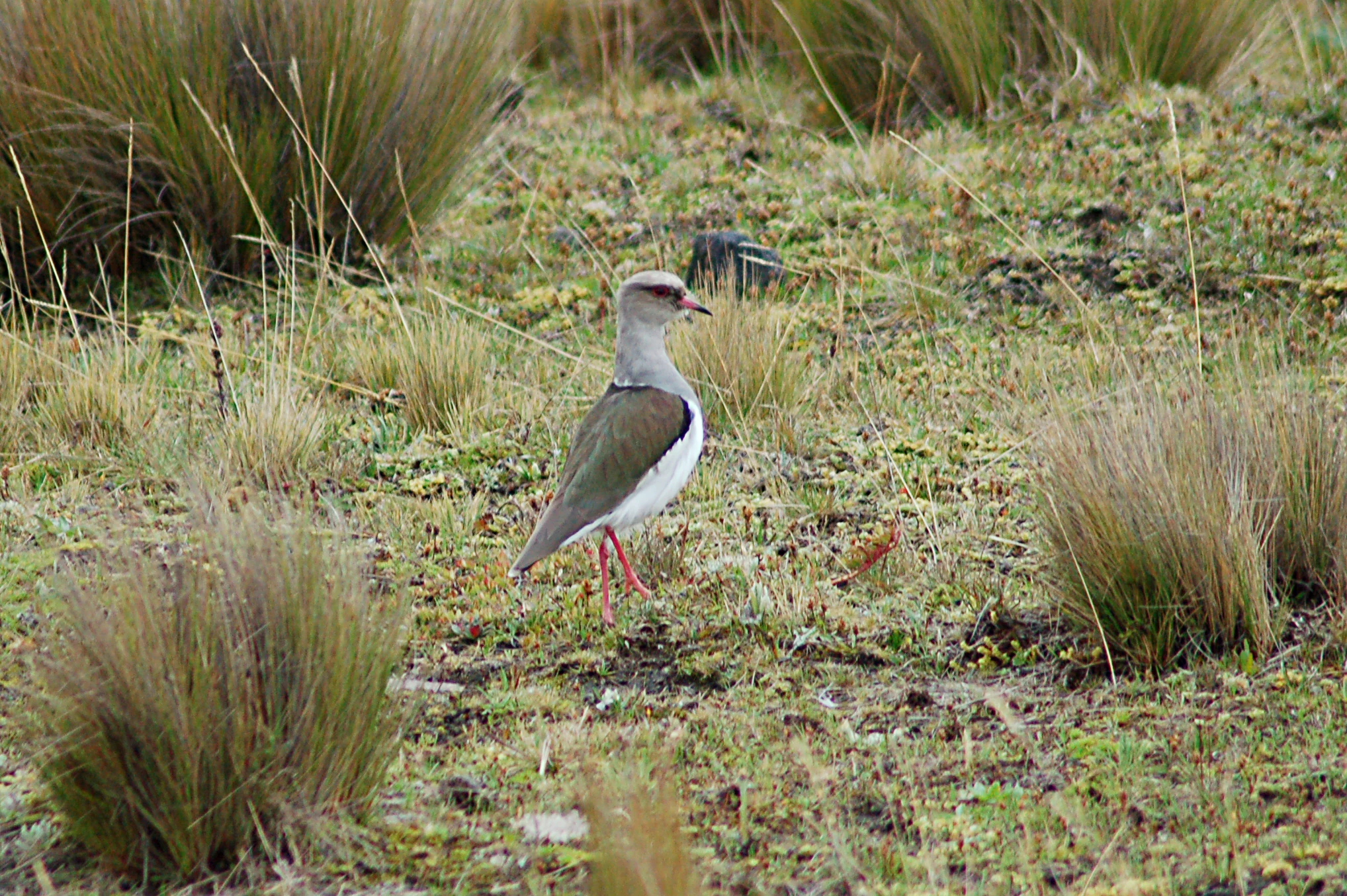
An Andean Lapwing bird standing in a grassy field of bunchgrass in the Andes.
An Andean Lapwing in the high Andean páramo ecosystem of Antisana National Park.

Antisana National Park ecosystems, habitats, and plant life

Antisana supports an unusually rich mosaic of ecosystems compressed into a single protected area, with at least nine distinct ecological formations recognized by Ecuador's environmental ministry. They range from nival and sub-nival environments near Volcán Antisana's summit, where lichens and mosses dominate, down through herbaceous and shrubby páramo, cloud forest, and multi-layered montane evergreen forest.

The altitudinal gradient runs from roughly 600 meters up to more than 5,700 meters, producing layered vegetation belts. Eastern foothills are covered by lower montane evergreen forest between roughly 600 and 1,300 meters, transitioning into lower montane forest between 1,300 and 2,000 meters. The cloud forest belt extends from about 2,000 to 2,900 meters, while upper montane forest and ceja andina occupy elevations from 2,900 to 3,600 meters. The páramo is broadly distributed between roughly 2,100 and 4,500 meters, and above 4,500 meters the landscape shifts to a specialized gelidofitia vegetation of lichens and mosses.

This layered structure creates a wide range of habitats for endemic and threatened species. The high páramo in particular holds significant botanical endemism, with notable species within families such as Brassicaceae, Gentianaceae, and Poaceae. Lower montane forests harbor valuable hardwoods including cedar, walnut, laurel de cera, motilón, arrayán, and ramos palm, many of which depend on the steep slopes and limited access of the area to remain in good condition.
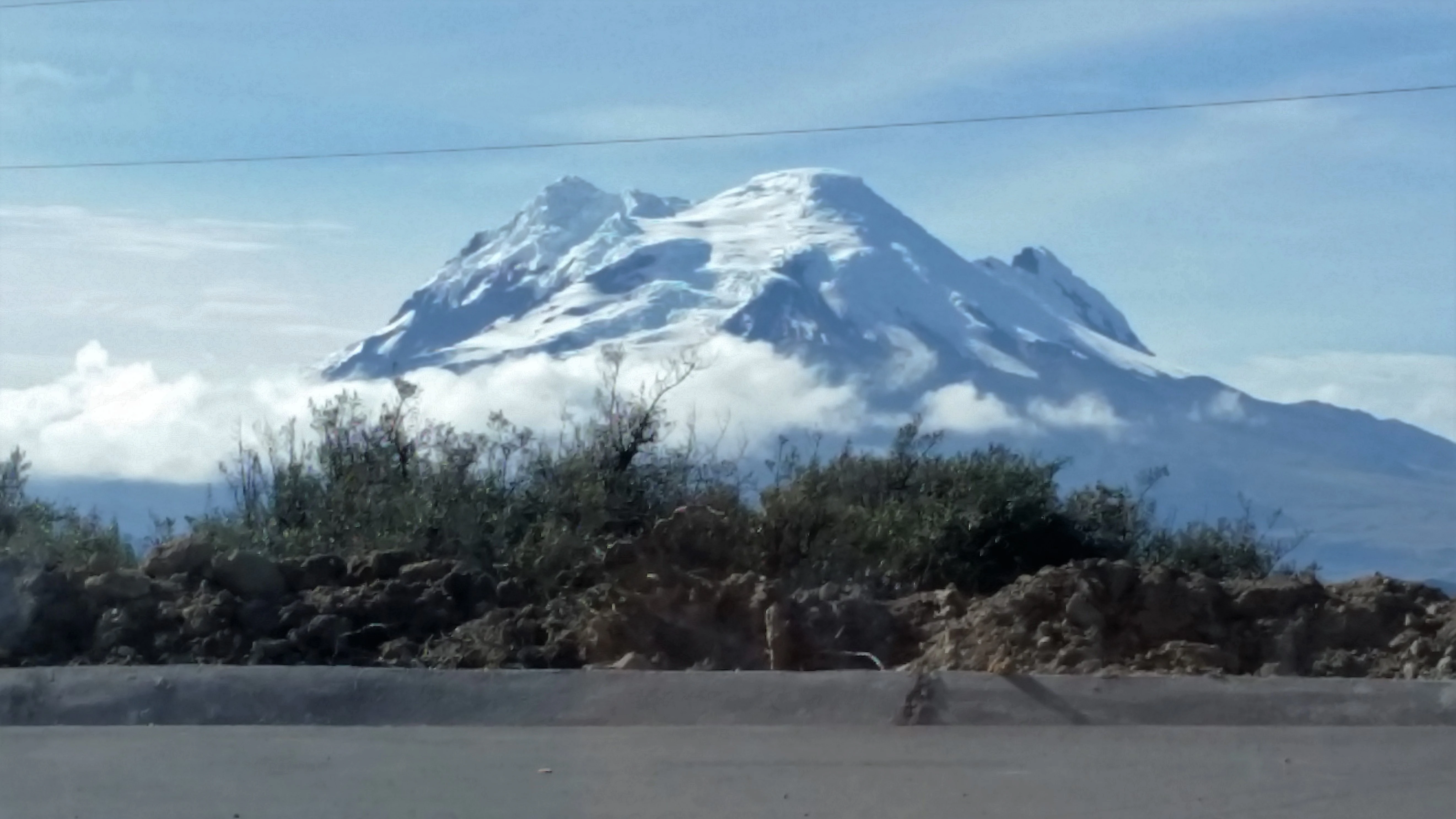
A wide shot of the Antisana volcano with a snow-capped summit partially obscured by clouds, viewed over a roadside area with rocky, scrubby vegetation in the foreground.
The snow-capped Antisana Volcano, a prominent peak in the Ecuadorian Andes.

Antisana National Park wildlife and species highlights

Antisana is home to a diverse high-Andean fauna, with seventy-three recorded mammal species spread across twenty-three families. Iconic large and medium-sized mammals include the spectacled bear, puma, mountain tapir, culpeo fox, páramo deer, and long-tailed weasel. The park's combination of páramo, cloud forest, and lower montane forest allows these species to move across elevation zones as conditions change seasonally.

The amphibian fauna is similarly rich, with forty-two recorded species including the Antisana toad, Osornophryne antisana, a species nearly endemic to the park. Members of the genus Atelopus were once important here as well, though their current status is uncertain. Reptiles are represented by nineteen species, with the Gymnophthalmidae family accounting for the largest share of recorded diversity.

Antisana is especially important for birds. Surveys around La Mica lagoon and surroundings have documented around fifty species, while the upper Quijos and Cosanga river basins and the Huacamayos range have produced a combined list of approximately 115 species. The park is recognized as one of the most important sites in Ecuador for the Andean condor, as well as for species such as the silvery grebe and Andean ibis, which find refuge in its high-altitude wetlands and along its cliffs.
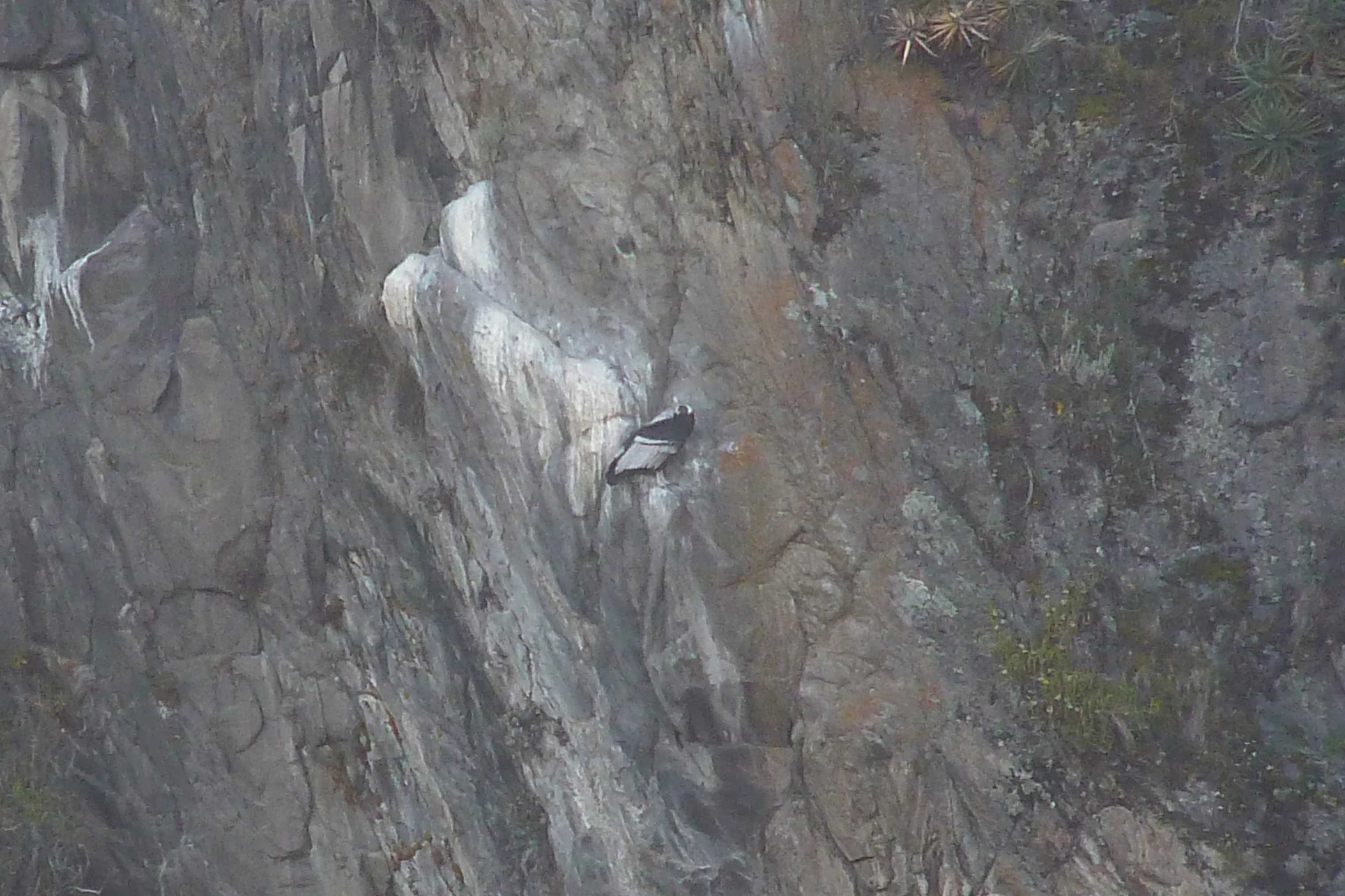
An Andean condor perched on a dark, craggy rock cliff.
An Andean condor resting on a steep rock face in the Antisana region.

Antisana National Park conservation status and protection priorities

Antisana's conservation importance rests on three interwoven pillars: biodiversity protection, watershed security, and landscape connectivity. The park safeguards nine distinct ecosystems and a steep altitudinal gradient that hosts an exceptional range of species, including several threatened or endemic plants and animals such as the spectacled bear, mountain tapir, and high-páramo endemics. Lower montane forests within the park also serve as refuges for valuable hardwood species that are heavily pressured elsewhere.

A central aspect of conservation at Antisana is the protection of high-altitude wetlands and headwaters. The páramo functions as a natural water regulator, capturing moisture and feeding rivers that flow to Quito and smaller communities. Preservation of these ecosystems is therefore critical not only for biodiversity, but for the long-term availability of clean water for major urban populations.

The park's strategic location also strengthens its conservation value, as it links with other major protected areas to form a continuous Andean conservation corridor. Reclassification as a national park in 2021 reinforced this role, while the work of the Fundación Antisana and community-oriented projects in the buffer zone, from sustainable trout farming to organic agriculture, help offset pressures on the natural landscape.

Antisana National Park cultural meaning and human context

The area around Antisana has a long history of human presence shaped by traditional highland agriculture and livestock raising. Surrounding the park, haciendas and small agricultural and pastoral properties reflect centuries of interaction between Andean communities and páramo landscapes, where people have depended on these environments for water, grazing, and crops.

The reclassification of Antisana from an ecological reserve to a national park in 2021 strengthened the framework for engaging surrounding communities through conservation partnerships. The Fundación Antisana, active in the region, has promoted community projects such as trout farming near Papallacta and Cosanga and organic hydroponic agriculture, helping local households diversify their economies while reducing pressure on natural resources inside the park.

Top sights and standout views in Antisana National Park

Antisana stands out for the sheer scale of its altitudinal and ecological diversity, packing glacial peaks, páramo wetlands, cloud forests, and rain-shadowed lower montane forests into a single protected unit. Its towering cliffs, particularly at El Isco, form one of Ecuador's most important strongholds for the Andean condor, while nearby lakes and wetlands such as La Mica host specialized high-Andean waterbirds.

The park is also distinguished by its hydrological role: the páramo and upper watersheds protected here sustain rivers that serve Quito and other communities, making Antisana as important for water security as it is for wildlife. Combined with its connectivity to neighboring reserves, the park contributes to one of the most robust Andean conservation corridors in northern Ecuador.

Best time to visit Antisana National Park

Antisana's high páramo and glacial landscapes can be visited year-round, but conditions vary substantially with the seasons. The dry months, generally falling within Ecuador's mid-year period, typically offer clearer skies, better visibility of the snow-capped peak, and more reliable access to páramo and lake areas, making them well suited for wildlife observation, birdwatching, and scenic photography.

The wetter months bring more frequent cloud cover and rain on the eastern slopes, especially in the cloud forest and lower elevations. These conditions can limit visibility but also enhance the lushness of the cloud forests and produce strong flows at the park's rivers and wetlands, which are important for waterbirds. Travelers interested in a balance of clear Andean views and forest activity often favor the transitional months on either side of the rainy season, when landscapes remain green and the chances of clear mornings are higher.

Monthly climate preview

Long-term monthly temperature and precipitation patterns across representative high elevation terrain

Parque nacional Antisana Climate Normals and Annual Temperature Rhythm

Representative coordinate records show sustained annual temperature ranges alongside measured monthly precipitation variations for Parque nacional Antisana. Reviewing the complete twelve-month climatology profile provides deeper context on long-term weather rhythms across the protected area.
Annual mean9 °C
8 °C10 °C
Jan10°
Feb10°
Mar10°
Apr10°
May10°
Jun
Jul
Aug
Sep
Oct10°
Nov10°
Dec10°
Warmest month
November

10.3 °C

Coolest month
July

7.9 °C

Wettest month
April

6.3 mm/day

Driest month
August

2 mm/day

Park location guide

Geography guide, regional context, and park location map for Antisana National Park

Antisana National Park park geography, regions, and map view in Ecuador

Understand where Antisana National Park sits in Ecuador through a broader geographic reading of the surrounding landscape, nearby location context, and its mapped position within the national park landscape.

How Antisana National Park fits into Ecuador

Ecuador is a presidential republic located in northwestern South America, with Quito as its capital and Guayaquil as its largest city. The country spans 283,561 km² and encompasses the Galápagos Islands, a volcanic archipelago famous for unique wildlife that helped shape Darwin's theory of evolution. Ecuador is a plurinational state with Spanish as the official language, though Kichwa and Shuar are recognized for indigenous peoples.

Wider geography shaping Antisana National Park in Ecuador

Ecuador is located in northwestern South America along the Pacific coast. It shares borders with Colombia to the north and Peru to the east and south. The country includes the Galápagos Islands, a volcanic archipelago in the Pacific Ocean approximately 1,000 km west of the mainland. The territory encompasses diverse terrain including the Amazon rainforest in the east, the Andean highlands in the center, and coastal plains along the Pacific.

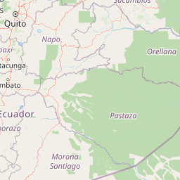
Map view of Antisana National Park

Use this park location map to pinpoint Antisana National Park in Ecuador, understand its exact geographic position, and read its mapped placement within the surrounding landscape more clearly.

Pigeon | © OpenStreetMap contributors

Location context for Antisana National Park

NapoPichincha
Recorded earthquake history

Explore Recorded Seismic History and Earthquake Data for Parque nacional Antisana

Consult the historical catalogue of seismic events associated by proximity to the protected landscapes of Parque nacional Antisana. Access documented earthquake records, including magnitudes and epicentre locations, to better understand the seismic history within this specific Andean region.

Parque nacional Antisana Earthquake History

Catalogued events

102 events

Strongest magnitude

Magnitude 6.4

Most recent event

Dec 19, 2025

This history includes earthquakes recorded inside the park or within 50 km of its borders

Visualizing high Andean volcanoes, glacial ice, and extensive páramo ecosystems

Parque nacional Antisana Photos and Landscape Scenery Exploration

Visual records reveal the dramatic altitudinal gradients and rugged volcanic terrain defining Parque nacional Antisana. Detailed photography captures glacial peaks, high altitude wetlands, and steep forest habitats across the protected area.

A medium shot of a Carunculated Caracara standing on a grassy, moss-covered ridge in a high-altitude Andean landscape.

A wide shot of the snowy, rugged Antisana Volcano partially obscured by heavy grey clouds, overlooking a vast, rolling high-altitude grassland plain with a small structure visible in the lower left.

An Andean Lapwing bird standing in a grassy field of bunchgrass in the Andes.

A wide shot of the Antisana volcano with a snow-capped summit partially obscured by clouds, viewed over a roadside area with rocky, scrubby vegetation in the foreground.

An Andean condor perched on a dark, craggy rock cliff.

Park atlas

Compare surrounding high altitude landscapes and regional conservation corridors

Other Parks Near Parque nacional Antisana and Connected Andean Protected Areas

Continue exploring protected areas linked to Parque nacional Antisana through shared Andean geography and high altitude ecosystems. Compare neighboring reserves across the Cordillera Real to understand broader regional conservation patterns.
National parkEcuador
Park boundaries overlap#1 closest

East

Sumaco Napo-Galeras National Park: Ecuador's Volcanic National Park Landscape

Explore protected areas and biodiversity in the Andean-Amazon transition.

Sumaco Napo-Galeras National Park protects a dramatic volcanic landscape in Ecuador, showcasing a significant elevation gradient that supports diverse cloud forest and Amazonian rainforest habitats. This national park is recognized for its endemic species and rich avifauna, offering a compelling case study for understanding protected land geography and ecological transitions within South America.

Area
2,067.49 km²
Established
1994
IUCN
II
Relief
Mountain
Biosphere reserveNapo
About 4.7 km away#2 closest

Southwest

Reserva Biológica Colonso-Chalupas: Protected Landscapes of the Upper Napo Basin

A critical vertical corridor of the Ecuadorian Andes and Amazon.

Reserva Biológica Colonso-Chalupas represents a unique bioclimatic transition, stretching nearly 4,000 meters in elevation. This biosphere reserve serves as a functional corridor connecting high-altitude páramo and cloud forests to warm, humid Amazonian lowlands, forming a key structural element of the eastern Andean conservation landscape.

Area
931.63 km²
Established
2014
Relief
Mountain
Climate
Alpine
National parkCotopaxi Province
17 km away#3 closest

West

Cotopaxi National Park: Ecuador's Mapped Protected Landscape and Regional Geography

Explore the geographic context of this national park.

Cotopaxi National Park represents a key protected landscape within Ecuador, located in Cotopaxi Province. This page facilitates detailed exploration of the park's mapped boundaries and its contribution to the regional geography. Understand the specific characteristics of this national park as part of a broader atlas of protected areas and natural terrains.

Area
333.93 km²
Established
1975
IUCN
II
Relief
Mountain
National parkEcuador
18 km away#4 closest

South

Llanganates National Park: Detailed Atlas Entry for Ecuador's Protected Landscape

Explore the mapped geography and regional context of this Ecuadorian national park.

Llanganates National Park is a designated national park offering rich opportunities for geographic and landscape exploration. As a significant protected area in Ecuador, it provides crucial context for understanding the country's natural terrain and the distribution of its conservation landscapes. This entry is designed to facilitate an atlas-style discovery of the park's location, boundaries, and its role within the broader geography of the region.

Area
2,197.07 km²
Established
1996
IUCN
II
Relief
Mountain
A pale, minimalist watercolor painting showing a wide, grassy field leading to distant, low mountain hills under a bright, light sky.
Wildlife reservePichincha
About 27 km away#5 closest

West

Refugio de Vida Silvestre Pasochoa: Volcanic Crater and Andean Forest Protected Area

Geographic atlas of the Pichincha volcanic highlands

Located in the Pichincha province, Refugio de Vida Silvestre Pasochoa protects an essential highland habitat defined by its steep volcanic crater walls and dense bamboo stands. This area provides a scientific reference for inter-Andean vegetation, featuring a sharp contrast between forested inner slopes and surrounding agricultural landscapes. Map the ecological gradient of this protected refuge and explore its role within the broader northern Andean geographic context.

Area
9.799 km²
Established
1996
IUCN
Ib
Relief
Mountain
A wide watercolor illustration showing a misty landscape with green trees in the midground and faint mountain peaks in the background.
Nature reserveEcuador
43 km away#6 closest

West

Reserva Ecológica Los Illinizas: Geographic Atlas and Andean Protected Nature Reserve

Volcanic terrain and cloud forest ecosystems in central Ecuador

Spanning across the provinces of Cotopaxi, Pichincha, and Santo Domingo de los Tsáchilas, Reserva Ecológica Los Illinizas preserves a significant vertical gradient of Andean ecosystems. The reserve protects the western flanks of the Illiniza volcanoes, Quilotoa, and El Corazón, offering a detailed look at high-altitude biodiversity and the transition from rugged mountain peaks to lush western cloud forests.

Area
1,342.33 km²
Established
1996
IUCN
Ia
Relief
Mountain
Watercolor illustration showing a panoramic view of a wide valley with green hills, a small stream, and forested clusters, rendered in a light and airy style.
Nature reservePichincha
About 50 km away#7 closest

Northwest

Reserva Geobotánica Pululahua: Protected Volcanic Caldera and Highland Ecosystems

A distinct geobotanical reserve in the Pichincha region of the Ecuadorian Andes.

Reserva Geobotánica Pululahua is a protected natural area centered on a massive, 12-kilometer-wide volcanic caldera. Its landscape features three prominent lava domes and a rare altitudinal gradient of vegetation, spanning from semi-dry mountain shrubland to dense cloud forest. This reserve serves as a critical study of volcanic geology and human-landscape interaction in the high Andes, offering a concentrated look at Ecuador's vertical ecological zonation.

Area
34.417 km²
Established
1966
Relief
Mountain
Climate
Subtropical
A horizontal watercolor painting depicting a purple mountain range in the background behind soft green rolling hills and a stream in the foreground.
National parkEcuador
About 56 km away#8 closest

North

Parque nacional Cayambe-Coca: Regional Geography and Protected Landscape Analysis

Equatorial volcanic peaks and Amazonian slope geography

Examine the physical geography of Parque nacional Cayambe-Coca, a protected area in Ecuador known for its extreme elevation shifts. The mapped terrain transitions from the glaciated summit of Volcán Cayambe through extensive páramo wetlands and montane cloud forests into the Amazonian foothills, providing a comprehensive case study of Andean environmental gradients.

Area
4,031.03 km²
Established
1970
IUCN
II
Relief
Mountain

Common questions about visiting, size, designation, and location context for Antisana National Park

Antisana National Park FAQs for park facts, access, geography, and protected area context

Find quick answers about Antisana National Park, including protected-area facts, park geography, trail and visitor context, and how the park fits into its surrounding country and regional landscape.
MoriAtlas Explorer

Continue Your Protected Areas Search Across the Global Atlas

Deepen your exploration by continuing the structured search for national parks and protected areas worldwide. Utilize the comprehensive filtering capabilities to compare different conservation landscapes and refine your understanding of global park geography. Discover more about the distribution and characteristics of protected natural areas.

Global natural geography