Mori Atlas logo
Protected areaÁrea Protegida Municipal Palmera de Saó

Understanding the unique riverine geography and ecological boundaries within the Santa Cruz lowlands.

Área Protegida Municipal Palmera de Saó: A Mapped Exploration of the Bolivian Chaco Protected Landscape

Área Protegida Municipal Palmera de Saó serves as a vital conservation landscape within the Cordillera province of the Santa Cruz department in Bolivia. The reserve spans the sedimentary plains of the Bolivian Chaco, specifically protecting the saó palm and diverse hardwood forest species along the western banks of the Río Grande. By mapping these protected boundaries, this resource provides an essential look at the intersection of traditional community livelihoods and the preservation of lowland Chaco ecosystems.

municipal protected areaBolivian Chacodry forestlowland Boliviasaó palmpalm conservation

Área Protegida Municipal Palmera de Saó

Protected area

Park overview

Structured park overview, official facts, and landscape profile for Área Protegida Municipal Palmera de Saó

Área Protegida Municipal Palmera de Saó park facts, protected area profile, and essential visitor context

Review the core facts for Área Protegida Municipal Palmera de Saó, including designation, size, terrain, visitor scale, habitats, and operating context in one park-focused overview.

About Área Protegida Municipal Palmera de Saó

Área Protegida Municipal Palmera de Saó is a municipal-level protected area in eastern Bolivia, situated in the country's lowlands and forming part of the broader Bolivian Chaco ecoregion. The reserve covers approximately 758 hectares within the Cordillera province of the Santa Cruz department, administratively part of the Municipal District of Riva Palacios in the municipality of Cabezas. Its eastern boundary follows the Río Grande, a major river of the Bolivian lowlands that shapes both the hydrology and ecological character of the surrounding landscape.

The reserve's identity is closely tied to the saó palm, a fan palm of the genus Trithrinax that thrives in the dry and seasonally dry conditions of the Chaco. While the palm occurs across parts of the lowlands, Palmera de Saó was created specifically as a precautionary conservation measure for this species, recognizing both its ecological importance and its role as the foundation of a thriving handcraft economy. Families in nearby communities such as Paurito, Tundi, Usuró, Tijera, Jorochi, the Guaraní pueblo of Santa Fe, and La Peña rely on saó leaves to weave hats, baskets, and other traditional craft items that represent an essential source of household income.

Beyond the saó palm, the protected area shelters other tree species of significant economic value, including ochoó, tajibo, and mara, the latter better known internationally as big-leaf mahogany. These species contribute to the area's dry-forest composition and underscore the broader forest resources the reserve helps to safeguard. Wildlife within the protected area reflects the typical fauna of the Chaco lowlands, with species such as the urina, jochi (capybara), iguana, and taitetú (peccary) present in the mosaic of habitats shaped by the riverine corridor and surrounding forest.

Although small in size, Palmera de Saó exemplifies the growing importance of municipal conservation instruments in lowland Bolivia. By placing management authority at the local level, with technical support from the departmental government, the reserve represents an effort to align biodiversity protection with the cultural and economic needs of communities whose livelihoods are directly tied to natural resources.

Quick facts and research context for Área Protegida Municipal Palmera de Saó

Área Protegida Municipal Palmera de Saó is a municipal-level protected area located in the lowlands of the Santa Cruz department in eastern Bolivia, within the Bolivian Chaco ecoregion. It lies in the Cordillera province, under the administration of the Municipal District of Riva Palacios in the municipality of Cabezas, and is bordered to the east by the Río Grande.

The reserve was legally created on 3 October 2006 through Law No. 3491 and is managed by the Municipal Government of Cabezas with support from the Departmental Government of Santa Cruz. Its core purpose is the conservation of the saó palm and the broader Chaco lowland ecosystem that supports local artisan economies, particularly in communities such as Paurito and nearby Guaraní settlements.

Protection and recognition

Examine the recorded terrestrial protection framework and formal conservation status.

Área Protegida Municipal Palmera de Saó Protection Status and Designated Scope

Terrestrial protection status records outline the documented management scope and designation framework established for Área Protegida Municipal Palmera de Saó. Official registry facts provide transparent baseline details regarding the conservation boundaries and administrative geography.

Protection details

Protection scope
Terrestrial
Transboundary protection
No
Park context

Deeper park guide and search-rich context for Área Protegida Municipal Palmera de Saó

Área Protegida Municipal Palmera de Saó history, landscape, wildlife, and travel context

Explore Área Protegida Municipal Palmera de Saó through its history, landscape character, ecosystems, wildlife, conservation priorities, cultural context, and seasonal travel timing in a structured park guide built for atlas discovery and search intent.

Why Área Protegida Municipal Palmera de Saó stands out

Área Protegida Municipal Palmera de Saó is best known for protecting the saó palm, a hardy fan palm whose leaves form the basis of a handcraft economy across multiple communities in the Santa Cruz lowlands. The reserve has become a focal point for conservation efforts aimed at preserving this single species and, with it, a traditional way of life. The protected area is also notable for its location along the Río Grande and its position within the Bolivian Chaco, where it preserves a mosaic of dry-forest vegetation, commercially valuable hardwoods such as ochoó, tajibo, and mara, and wildlife species characteristic of the Chaco lowlands.

Área Protegida Municipal Palmera de Saó history and protected-area timeline

Área Protegida Municipal Palmera de Saó was legally established on 3 October 2006 through Law No. 3491, enacted during the first government of Evo Morales. Its creation marked an early example of Bolivia's expanding framework of municipal-level conservation, in which local governments take direct responsibility for protecting natural areas of cultural and economic importance within their jurisdictions.

The founding legislation responded to growing concern over the status of the saó palm and the traditional handcraft communities that depend on it. By formally designating a protected area dedicated to this species, the law sought to combine biodiversity conservation with the safeguarding of a centuries-old craft tradition practiced across several communities in the Santa Cruz lowlands, including Paurito and the Guaraní pueblo of Santa Fe.

Following its establishment, the reserve has been administered by the Municipal Government of Cabezas, with collaborative support and oversight from the Departmental Government of Santa Cruz through its Directorate of Protected Areas. This arrangement reflects the multi-level governance model increasingly applied to protected areas in Bolivia, where municipal autonomy, departmental coordination, and community involvement intersect in conservation management.

Área Protegida Municipal Palmera de Saó landscape and geographic character

The landscape of Área Protegida Municipal Palmera de Saó reflects the character of the Bolivian Chaco lowlands: a mosaic of dry forests, scrubby vegetation, and seasonally variable terrain shaped by the Río Grande, which traces the reserve's eastern boundary. The terrain is generally flat to gently undulating, typical of the broad alluvial and sedimentary plains that dominate this part of eastern Bolivia.

The presence of the Río Grande along the eastern margin introduces a riverine corridor that contrasts with the drier interior habitats of the reserve. This contrast supports variations in vegetation cover and moisture availability, creating environmental gradients that influence both plant distribution and wildlife movement through the protected area. The overall landscape is shaped more by vegetation patterns and subtle elevation changes than by dramatic relief, lending the reserve a quiet, expansive character typical of lowland Chaco.

Área Protegida Municipal Palmera de Saó ecosystems, habitats, and plant life

Área Protegida Municipal Palmera de Saó sits within the Bolivian Chaco ecoregion, a transitional zone between the wetter lowlands to the north and the drier Gran Chaco to the south. The reserve's vegetation reflects the dry-forest character typical of this region, dominated by hardy, drought-adapted species capable of withstanding seasonal water stress.

Alongside the saó palm, which gives the area its name and conservation mandate, the reserve protects other tree species of considerable economic and ecological importance. Ochoó and tajibo, both native hardwoods, contribute to the structural and commercial value of the forest, while the mara or big-leaf mahogany adds a high-profile species with both national and international conservation relevance. Together, these trees form a diverse arboreal mosaic that supports the broader ecosystem functions of the reserve.

The riverine influence of the Río Grande introduces wetter microhabitats along the eastern edge, supporting different vegetation patterns from the drier interior. This ecological transition creates habitat variety within a relatively compact area and broadens the niche space available to native wildlife.

Área Protegida Municipal Palmera de Saó wildlife and species highlights

The wildlife of Área Protegida Municipal Palmera de Saó is typical of the Bolivian Chaco lowlands, characterized by species adapted to seasonal drought and a mix of dry forest and riverine habitats. Mammals documented in the area include the jochi (capybara), a large semi-aquatic rodent often associated with watercourses, and the taitetú, a native peccary that moves through the understory of dry forests.

Reptiles such as iguanas contribute to the reserve's fauna, occupying both forested areas and more open environments where sunlight and basking sites are abundant. The urina, a small felines and carnivores representative of the Chaco, also inhabits the area, completing a presence of native predators and prey species that characterize lowland ecosystems in this part of Bolivia.

The combination of dry-forest interior and riverine edge habitats provides a varied landscape for wildlife, supporting both resident species and those moving through the broader Chaco in search of food, water, or shelter.

Área Protegida Municipal Palmera de Saó conservation status and protection priorities

Área Protegida Municipal Palmera de Saó represents a focused, species-driven conservation effort within the Bolivian lowlands. Its primary mandate is the protection of the saó palm and the broader forest environment that supports it, addressing concerns about overexploitation and habitat loss that could undermine both natural populations and the handcraft economy dependent on them.

The reserve also conserves habitat for other commercially valuable tree species, including ochoó, tajibo, and mara, helping to prevent unsustainable extraction from a key forest area. Through its establishment as a municipal protected area, Palmera de Saó exemplifies a decentralized approach to conservation in Bolivia, where local governments assume direct management responsibility while coordinating with departmental authorities.

Pressures on the reserve remain significant. The expansion of agricultural frontiers, illegal logging of high-value trees for furniture production, and poaching of native wildlife all pose ongoing threats. Conservation efforts therefore extend beyond law-based designation into active management by the Municipal Government of Cabezas and its partners, who must balance the protection of biodiversity with the economic needs of communities whose livelihoods are intertwined with the forest.

Área Protegida Municipal Palmera de Saó cultural meaning and human context

The cultural significance of Área Protegida Municipal Palmera de Saó is deeply tied to the saó palm and the artisan communities that have long depended on its leaves. Communities such as Paurito, Tundi, Usuró, Tijera, Jorochi, La Peña, and the Guaraní pueblo of Santa Fe have built livelihoods around the traditional craft of weaving saó leaves into hats, baskets, and other products that hold both economic and cultural value.

Among these communities, the Guaraní pueblo of Santa Fe adds an important indigenous dimension to the reserve's cultural context, reflecting the deep and longstanding relationship between local peoples and the Chaco environment. The protected area thus encompasses not only an ecological mandate but also a commitment to preserving the traditional knowledge, livelihoods, and identity of communities whose connection to the saó palm spans generations.
Monthly climate preview

Long-term representative coordinate measurements of temperature and monthly precipitation spread

Área Protegida Municipal Palmera de Saó Climate Normals and Annual Weather Rhythms

Representative coordinate records for Área Protegida Municipal Palmera de Saó demonstrate measured monthly temperature variations alongside shifting precipitation rates from 1991 through 2020. Reviewing the comprehensive monthly climate profile provides deeper context on long-term meteorological averages across the protected area.
Annual mean24 °C
21 °C27 °C
Jan26°
Feb26°
Mar25°
Apr24°
May22°
Jun21°
Jul21°
Aug23°
Sep25°
Oct27°
Nov27°
Dec26°
Warmest month
October

27 °C

Coolest month
July

20.6 °C

Wettest month
January

5.4 mm/day

Driest month
July

1.2 mm/day

Park location guide

Geography guide, regional context, and park location map for Área Protegida Municipal Palmera de Saó

Área Protegida Municipal Palmera de Saó park geography, regions, and map view in Bolivia

Understand where Área Protegida Municipal Palmera de Saó sits in Bolivia through a broader geographic reading of the surrounding landscape, nearby location context, and its mapped position within the national park landscape.

How Área Protegida Municipal Palmera de Saó fits into Bolivia

Bolivia, officially the Plurinational State of Bolivia, is a landlocked country in central South America. It features diverse geography including the Andean mountain range, Amazonian plains, Gran Chaco, and the Pantanal wetland. The country has a population of approximately 11.4 million and is administratively divided into nine departments, with La Paz as the seat of government and Sucre as the constitutional capital.

Wider geography shaping Área Protegida Municipal Palmera de Saó in Bolivia

Bolivia is located in central South America, bordered by Brazil to the north and east, Paraguay to the southeast, Argentina to the south, Chile to the southwest, and Peru to the west. The country is divided between a western Andean region and tropical lowlands to the east and north. It includes the Amazonian plain, Gran Chaco, temperate valleys, the high-altitude Altiplano plateau, and part of the Pantanal wetland along its eastern border.

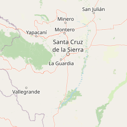
Map view of Área Protegida Municipal Palmera de Saó

Use this park location map to pinpoint Área Protegida Municipal Palmera de Saó in Bolivia, understand its exact geographic position, and read its mapped placement within the surrounding landscape more clearly.

Pigeon | © OpenStreetMap contributors

Location context for Área Protegida Municipal Palmera de Saó

Santa Cruz
Park atlas

Compare adjacent Chaco lowland reserves and connected protected landscapes

Parks Near Área Protegida Municipal Palmera de Saó and Regional Protected Areas

Browsing other protected areas near Área Protegida Municipal Palmera de Saó reveals wider ecological patterns across the Bolivian Chaco lowlands. Evaluating these adjacent lowland reserves helps contextualize regional dry-forest conservation and riverine habitats along the Río Grande.
A watercolor painting showing a landscape of sandy dunes, small pools of water, and green vegetation against a white background.
Regional parkSanta Cruz
About 35 km away#1 closest

Northwest

Parque Regional Lomas de Arena: Protected Landscapes and Geographic Features

Inland dune and Chaco forest ecosystems in the Santa Cruz lowlands

Covering 14,000 hectares near Santa Cruz de la Sierra, Parque Regional Lomas de Arena showcases a rare inland sand dune field anchored by transitional Chaco forest and savanna. This protected area provides a unique window into the geography of the Bolivian lowlands, where lagoon habitats and sandy ridges create a distinct ecological mosaic that bridges historical Chané heritage with modern conservation efforts.

Area
140.759 km²
Established
1989
IUCN
V
Relief
Lowland
A soft watercolor painting showing a winding river through a valley with trees and palms on the banks and rolling hills in the background.
Nature reserveSanta Cruz
About 55 km away#2 closest

Northwest

Parque de Protección Ecológica del Río Piraí: Protected Geography and Riverine Landscapes

Nature reserve and flood-control corridor in Santa Cruz, Bolivia

This nature reserve encompasses a narrow, sediment-rich corridor following the Río Piraí. It protects representative lowland habitats including Chiquitano dry forest and gallery woodlands, while balancing vital flood-mitigation roles against the pressures of urban expansion. Explore the map of this unique alluvial landscape to understand its ecological significance and role in the regional geography of Santa Cruz.

Area
15.868 km²
Established
1991
Relief
Lowland
Climate
Tropical
National parkSanta Cruz Department
About 69 km away#3 closest

West

Amboró National Park: Its Protected Area Identity and Geographic Context

Mapped boundaries and regional landscape details.

Amboró National Park is a designated national park situated within the Santa Cruz Department, Bolivia. This entry provides detailed insights into its protected landscape, focusing on its geographical significance and mapped boundaries. Users can explore how Amboró National Park fits into the broader regional geography, enhancing their understanding of conservation areas and mapped natural terrains for atlas-based research and discovery. Its specific location and protected status are crucial for understanding its ecological and geographic role.

Area
4,425 km²
Established
1984
IUCN
II
Relief
Mountain
National parkCochabamba Department
About 164 km away#4 closest

West

Carrasco National Park: National Park Status and Protected Landscape Geography

Explore mapped boundaries within Cochabamba Department.

Carrasco National Park, situated within the Cochabamba Department, represents a critical national park entity. This focus provides users with an atlas-centric view of its protected landscape, detailing its geographic significance and mapped features. Understand the park's terrain and regional context, offering a clear perspective on its conservation value and mapped presence.

Area
6,226 km²
Established
1991
IUCN
II
Relief
Mountain
National parkChuquisaca Department
About 183 km away#5 closest

Southwest

Iñao National Park and Integrated Management Natural Area: Bolivia National Park and Protected Landscape

Explore the Serranía del Iñao's geography and conservation role.

Iñao National Park and Integrated Management Natural Area is a protected territory located within Chuquisaca Department, Bolivia, centered on the prominent Serranía del Iñao mountain range. This page offers detailed geographic context and an atlas perspective on the park's landscape, its role as a national park, and its contribution to regional conservation efforts in the Andean foothills.

Area
2,630.9 km²
Established
2004
IUCN
II
Scope
Terrestrial
National parkBolivia
About 201 km away#6 closest

Southeast

Kaa-Iya del Gran Chaco National Park and Integrated Management Natural Area: Bolivia's National Park and Protected Landscape

Explore the mapped geography and regional natural landscape.

Kaa-Iya del Gran Chaco National Park and Integrated Management Natural Area stands as a crucial component of Bolivia's protected lands, offering a distinct entry point for exploring its natural geography. This page details the park's status as a national park and integrated management natural area, providing context for its mapped boundaries and its role within the country's diverse landscapes. Engage with structured information designed to illuminate the park's geographic setting and its significance for atlas-style exploration and understanding of Bolivia's protected areas.

Area
34,411.1 km²
Established
1995
Relief
Upland
Climate
Subtropical
A horizontal watercolor painting showing a soft mountain landscape with gentle green hills, a small valley, and several palm trees, set against a light, neutral background.
Protected landscapeChuquisaca
About 221 km away#7 closest

West

Área natural de manejo integrado El Palmar: Protected Landscape Geography and Map

Andean mountain ecosystems and endemic palm habitat in Chuquisaca.

Investigate the complex geomorphology of Área natural de manejo integrado El Palmar, a protected area in the Cordillera Oriental of Bolivia. This atlas resource covers the interplay between high-altitude serranías, palm-filled quebradas, and the cultural heritage of the Yampara nation, offering a structured look at its protected boundaries and diverse Andean environment.

Area
594.8 km²
Established
1997
Relief
Mountain
Climate
Mediterranean
Protected areaCochabamba
About 224 km away#8 closest

West

Area Natural Lagarpampa: Protected Inter-Andean Landscapes and Regional Geography

Community-led conservation in the Cochabamba dry valleys.

Spanning over thirty thousand hectares, Area Natural Lagarpampa serves as a significant example of community-driven land protection. The geography features an intricate mix of semi-arid slopes, seasonally active watercourses, and dry-forest ravines that define this part of the Cochabamba highlands. This landscape supports a vital population of the red-fronted macaw, illustrating the intersection between rural agricultural heritage and specialized ecological preservation within the Andean valley system.

Area
303.08 km²
Established
2009
Relief
Upland
Climate
Arid

Common questions about visiting, size, designation, and location context for Área Protegida Municipal Palmera de Saó

Área Protegida Municipal Palmera de Saó FAQs for park facts, access, geography, and protected area context

Find quick answers about Área Protegida Municipal Palmera de Saó, including protected-area facts, park geography, trail and visitor context, and how the park fits into its surrounding country and regional landscape.
MoriAtlas Explorer

Continue Your Protected Areas Search Across the Global Atlas

Deepen your exploration by continuing the structured search for national parks and protected areas worldwide. Utilize the comprehensive filtering capabilities to compare different conservation landscapes and refine your understanding of global park geography. Discover more about the distribution and characteristics of protected natural areas.

Global natural geography