
Mori Atlas logo
Nature reserveAubachtal bei Rabenscheid

A diverse mosaic of stream-fed wetlands and meadows within the Hoher Westerwald uplands

Aubachtal bei Rabenscheid Nature Reserve: Protected Landscape and Regional Geography

(Naturschutzgebiet Aubachtal bei Rabenscheid)

Aubachtal bei Rabenscheid represents a critical ecological corridor within the Hessen region of Germany. This nature reserve encompasses a five-kilometre stretch of the Aubach, sustaining a rich assembly of sedge-dominated mires, tall-herb communities, and damp hardwood forests. By preserving these near-natural floodplain habitats, the site maintains a vital refuge for specialized wetland species within the wider agricultural and forested landscape of the Westerwald plateau.

nature reservestream valleyfloodplain forestwet meadowtall-herb meadowsedge mire
A flat-style digital illustration showing a mountain range with a two-tiered waterfall, a meandering stream in the foreground, and pine trees framing the scene.

Aubachtal bei Rabenscheid

Nature reserve

Park overview

Structured park overview, official facts, and landscape profile for Aubachtal bei Rabenscheid

Aubachtal bei Rabenscheid park facts, protected area profile, and essential visitor context

Review the core facts for Aubachtal bei Rabenscheid, including designation, size, terrain, visitor scale, habitats, and operating context in one park-focused overview.

About Aubachtal bei Rabenscheid

Aubachtal bei Rabenscheid is a compact, ecologically intensive nature reserve in the Westerwald region of central Hesse. Although it covers only around sixty-three hectares, the site concentrates a remarkable variety of wetland and forest habitats in close proximity, making it a high-value conservation area within the regional landscape of forest, pasture, and small villages that characterises the Hoher Westerwald plateau.

The reserve follows the Aubach, a small tributary of the Dill, for roughly five kilometres through a narrow valley bordered by meadows, floodplain forests, and sloping woodland edges. Its mosaic of near-natural stream floodplain communities includes sedge mires (Seggenriede), tall-herb meadows (Hochstaudenfluren), wet sycamore-ash-alder forests, and permanently waterlogged alder swamp woodland. A small successional woodland area has developed on formerly intensively used agricultural land along the northern margin of the protected zone, adding a further structural dimension to the habitat mosaic.

Because these habitats occur in small, interlocking patches rather than as uniform blocks, the reserve supports an unusually high species richness for its size, including many rare or strongly threatened species of plants, butterflies, dragonflies, birds, and freshwater invertebrates. Its inclusion in the Habitats Directive site Hoher Westerwald and in the European bird protection area of the same name gives it standing within the European Natura 2000 network, while on the national level it is protected as a Naturschutzgebiet under Hessian conservation law, managed by the Regierungspräsidium Gießen.

Quick facts and research context for Aubachtal bei Rabenscheid

Aubachtal bei Rabenscheid is a German nature reserve of approximately sixty-three hectares in the Lahn-Dill-Kreis of Hesse, designated in December 1984 and managed by the Regierungspräsidium Gießen. It lies northeast of the village of Rabenscheid, a district of the municipality of Breitscheid, and adjoins the neighbouring protected area Aubachtal bei Langenaubach, which together encompass a continuous stretch of the Aubach valley.

The site forms part of both the EU Habitats Directive site Hoher Westerwald (5314-301) and the European bird protection area Hoher Westerwald (5314-450). It carries the national identifier 1532016 and the World Database on Protected Areas entry 162256, and is classified within the IUCN Category IV framework as a Habitat/Species Management Area. Its protected status is grounded in Hessian nature conservation legislation.

Protection and recognition

Documented terrestrial protection metrics and management history for Aubachtal bei Rabenscheid

Aubachtal bei Rabenscheid Protection Status and Designation History

Aubachtal bei Rabenscheid holds a documented terrestrial protection status established in 1984 within the official World Database on Protected Areas. Structured records outline the formal designation history and management scope associated with this protected landscape.

Protection details

Protection scope
Terrestrial
Designated year
1984
Transboundary protection
No
WDPA ID
162256
Park context

Deeper park guide and search-rich context for Aubachtal bei Rabenscheid

Aubachtal bei Rabenscheid history, landscape, wildlife, and travel context

Explore Aubachtal bei Rabenscheid through its history, landscape character, ecosystems, wildlife, conservation priorities, cultural context, and seasonal travel timing in a structured park guide built for atlas discovery and search intent.

Why Aubachtal bei Rabenscheid stands out

The reserve is best known for its compact but exceptionally rich floodplain habitats along the Aubach, where near-natural wet meadows, tall-herb communities, and damp hardwood forests create conditions for numerous rare species to coexist in a very small area. It is particularly recognised for its butterfly fauna, with 214 species of moths and butterflies recorded on its flowering meadows and structured forest edges, including the strongly protected violet copper (Lycaena helle). It is also notable as a refuge for the spring snail Bythinella dunkeri, whose presence confirms the excellent water quality of the Aubach, and as a regular foraging ground for the black stork (Ciconia nigra), one of Europe's most sensitive wetland bird species. Its position within the transnational Hoher Westerwald Natura 2000 complex gives it significance well beyond its local footprint.
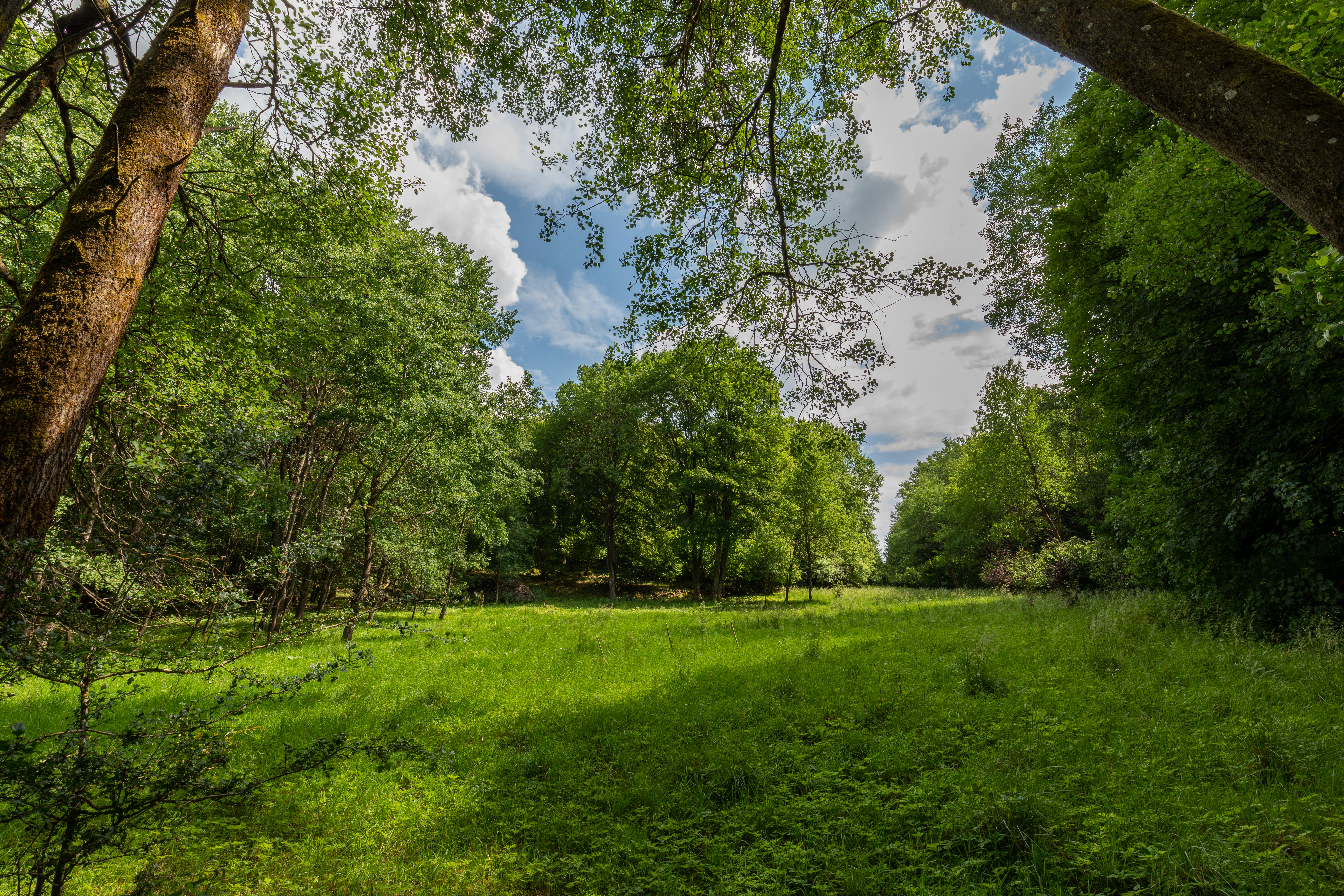
A bright green meadow opening between dense, leafy deciduous trees under a partially cloudy blue sky.
A lush green meadow surrounded by dense forest in the Aubachtal bei Rabenscheid nature reserve.

Aubachtal bei Rabenscheid history and protected-area timeline

The area that is today Aubachtal bei Rabenscheid was placed under formal nature protection on 5 December 1984, when it was designated as a Naturschutzgebiet under Hessian law and given the official identifier 1532016. The designation recognised both the ecological value of the Aubach floodplain and the unusually rich flora and fauna documented there.

In the decades that followed, the reserve was integrated into larger European conservation frameworks, first as part of the Habitats Directive site Hoher Westerwald (5314-301) and subsequently within the European bird protection area Hoher Westerwald (5314-450). In 2013 a management plan was prepared for the wider Habitats Directive area, detailing measures tailored to the specific conditions of the reserve, including the selective removal of encroaching woody growth, grazing with cattle, and one- or two-cut mowing regimes aimed at maintaining the open wet meadows, tall-herb communities, forest edges, and stream floodplains that define the site.

Aubachtal bei Rabenscheid landscape and geographic character

The landscape of Aubachtal bei Rabenscheid is shaped by the narrow valley of the Aubach as it cuts through the gently rolling uplands of the Westerwald. For about five kilometres the stream flows between low, often sloping valley sides, with the protected area concentrated on the valley floor and lower slopes south of the local road L 3044.

Within this valley setting the relief transitions from small-scale floodplain flats to slightly raised terrace-like areas and wooded banks. The southernmost extent of the protected zone lies near the historic Fischbach-Mühle mill, an anchor point in the local cultural landscape. Beyond the valley margins, the wider setting is dominated by the mixed forest, pasture, and dispersed settlement pattern typical of the Hoher Westerwald, framing the reserve as a distinct ecological corridor within an otherwise upland agricultural and forestry landscape.
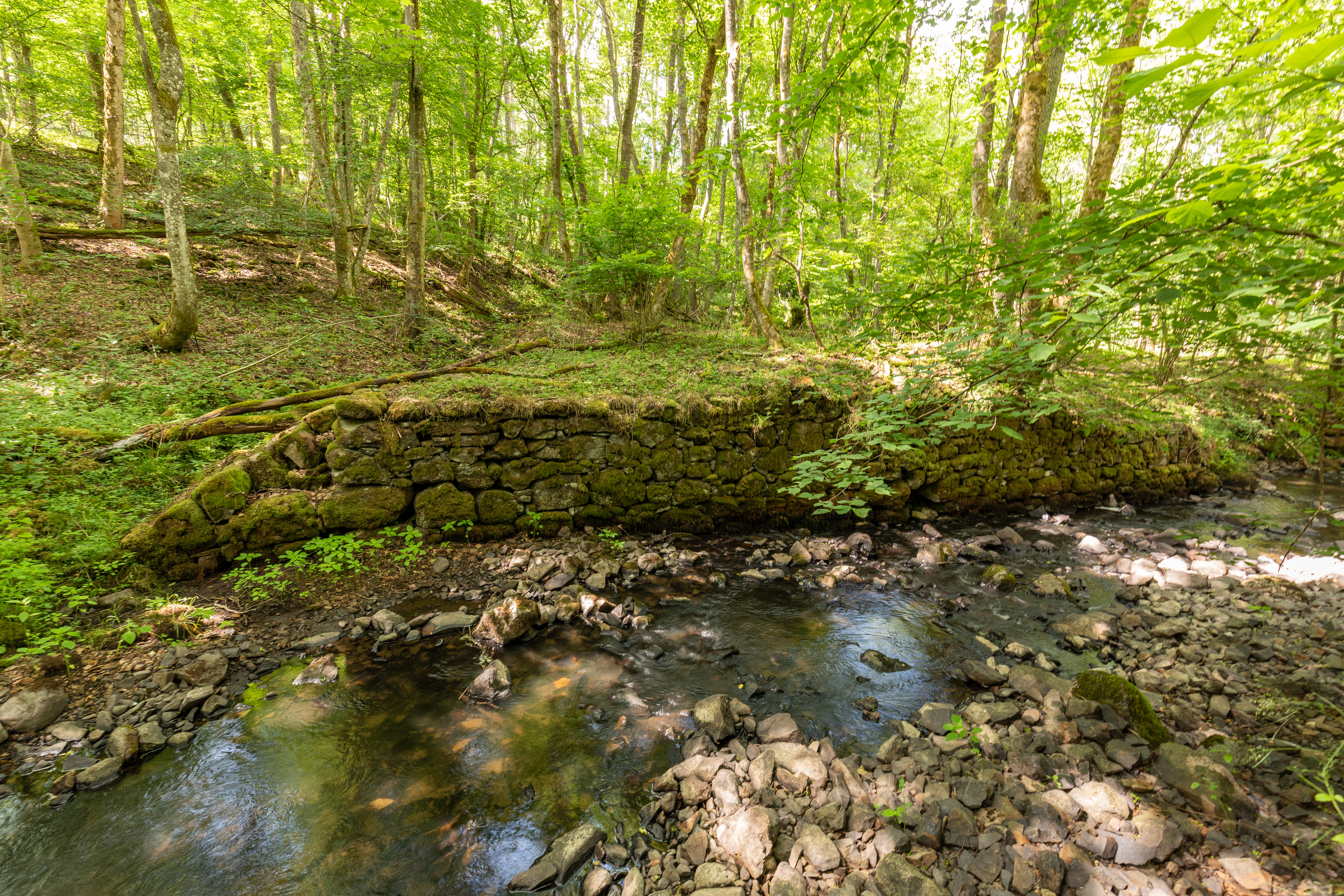
A small, shallow forest stream flows past a mossy, historic-looking stone retaining wall, set within a lush, deciduous green forest.
A shaded stream and stone retaining wall in the Aubachtal bei Rabenscheid nature reserve.

Aubachtal bei Rabenscheid ecosystems, habitats, and plant life

Ecologically, Aubachtal bei Rabenscheid is defined by the close interweaving of near-natural stream floodplain habitats with adjacent woodland and meadow communities. The reserve's core habitats are wet sedge mires, flowering tall-herb meadows, damp hardwood forests dominated by sycamore, ash, and alder, and permanently waterlogged alder swamp forests that depend on consistent saturation from the Aubach and its floodplain.

This small-scale mosaic produces conditions suitable for many moisture-dependent plant species that have become rare elsewhere in the region, among them thread rush (Juncus filiformis), grey sedge (Carex canescens), globeflower (Trollius europaeus), marsh cinquefoil (Potentilla palustris), early purple orchid (Orchis mascula), bogbean (Menyanthes trifoliata), monk's hood (Aconitum napellus), and northern bedstraw (Galium boreale). The botanical richness of the meadows and forest edges in turn underpins the site's exceptional invertebrate diversity, while the clean, well-oxygenated water of the Aubach itself supports a specialist freshwater fauna adapted to cold, stable spring-fed conditions.
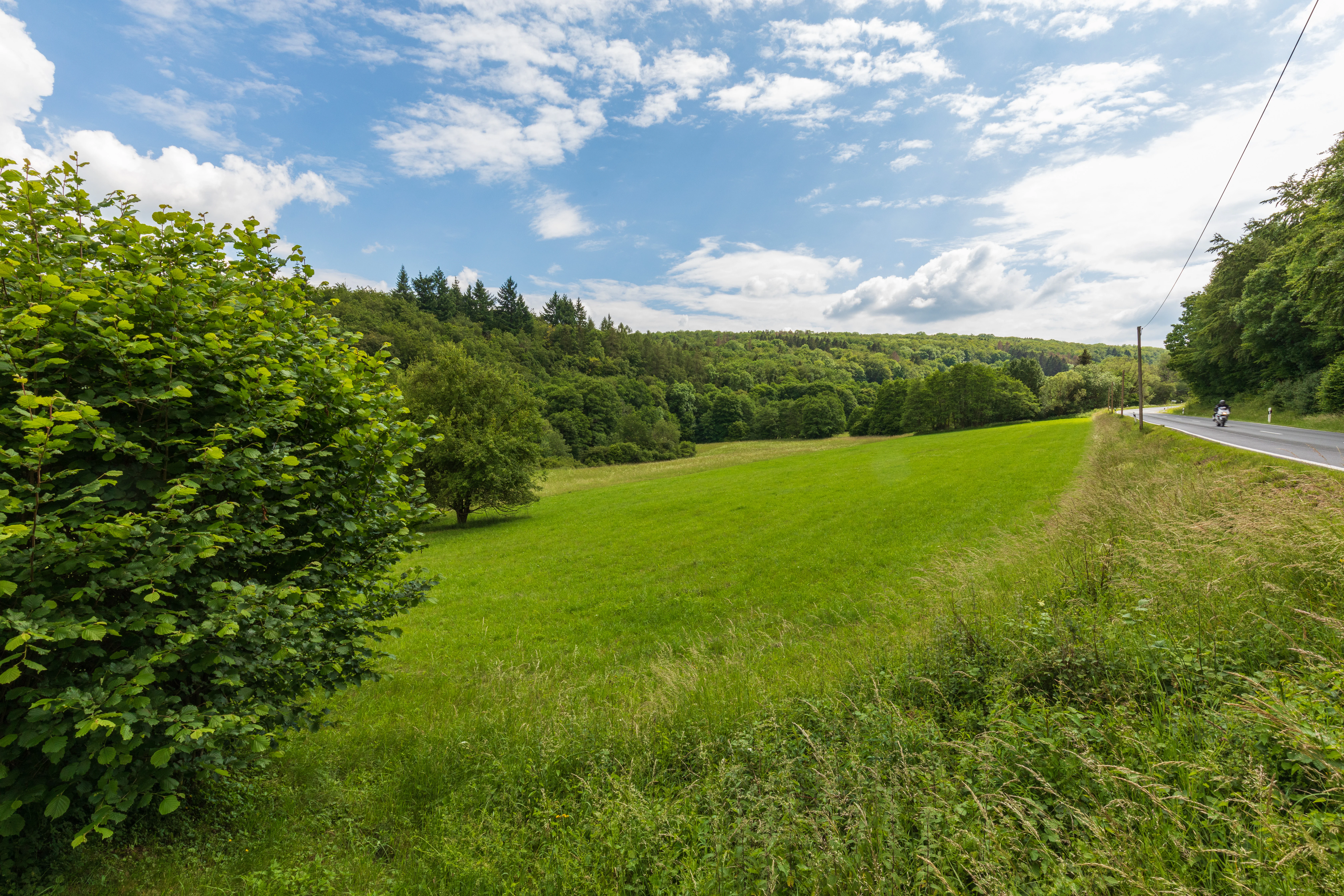
A green meadow landscape under a blue sky with white clouds, bordered by dense deciduous forests and an adjacent road.
A view of the open meadows and bordering woodlands at the Aubachtal bei Rabenscheid nature reserve.

Aubachtal bei Rabenscheid wildlife and species highlights

The wildlife of Aubachtal bei Rabenscheid reflects the high habitat quality of the reserve's wet meadows, forest edges, and clean stream. Black storks (Ciconia nigra) are regularly recorded as foraging visitors, taking advantage of the undisturbed wet meadows and stream margins. Other characteristic bird species of the site include meadow pipit (Anthus pratensis), white-throated dipper (Cinclus cinclus), and whinchat (Saxicola rubetra), all of which depend on open wetland and stream-side habitats.

The reserve is particularly notable for its invertebrate fauna. Surveys have recorded 214 species of moths and butterflies across the flowering meadows and structured woodland edges, including the violet copper (Lycaena helle), the poplar admiral (Limenitis populi), the purple emperor (Apatura iris), and the pearl-bordered fritillary (Boloria euphrosyne). Dragonflies associated with clean, well-vegetated stream habitats are also present, including the beautiful demoiselle (Calopteryx virgo) and the golden-ringed dragonfly (Cordulegaster boltonii). In the Aubach itself, the spring snail Bythinella dunkeri is a key indicator of consistently high water quality and intact small-stream ecology.
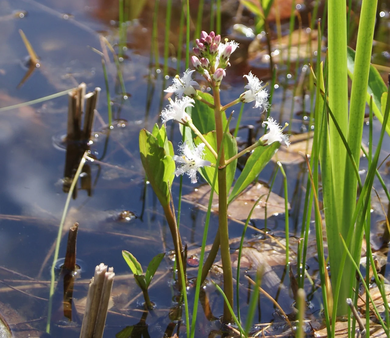
A close-up shot of a Bogbean plant, Menyanthes trifoliata, with white, fringed, star-shaped flowers and pinkish buds emerging from shallow water, surrounded by reeds.
A Bogbean (Menyanthes trifoliata) flowering in the wetlands of the Aubachtal bei Rabenscheid.

Aubachtal bei Rabenscheid conservation status and protection priorities

From a conservation perspective, Aubachtal bei Rabenscheid is significant far beyond its modest size because it preserves a functionally intact stream floodplain system in a region where such habitats have become increasingly fragmented. Its combination of wet meadows, tall-herb communities, damp hardwood forests, and alder swamp woodland supports species groups that are nationally and regionally declining, while the clean water of the Aubach sustains a specialist freshwater fauna of high conservation interest.

The reserve's formal status under Hessian law as a Naturschutzgebiet since 1984 is reinforced by its integration into European conservation structures through membership in the Habitats Directive site Hoher Westerwald and the European bird protection area of the same name. A 2013 management plan for the wider Habitats Directive area sets out active conservation measures specifically for the reserve, including targeted removal of encroaching woody vegetation, cattle grazing, and one- or two-cut mowing designed to maintain the open character of the wet meadows, tall-herb stands, forest edges, and floodplain that underpin its biodiversity value.

Aubachtal bei Rabenscheid cultural meaning and human context

The cultural context of Aubachtal bei Rabenscheid is closely tied to the traditional rural landscape of the Westerwald. The valley has long been shaped by small-scale agricultural use, particularly hay-making on the wet meadows and low-intensity grazing, while historic watermills such as the denkmalgeschützte Fischbach-Mühle reflect the historical use of the Aubach as an energy source for milling.

The abandonment of some formerly mown wet meadows has allowed natural successional woodland to develop along parts of the northern margin of the reserve, illustrating the broader shift in land use that has occurred across the Westerwald. The reserve today represents a careful balance between preserving these traditional landscape elements and allowing ecological processes to recover, situating the site at the intersection of regional cultural heritage and modern conservation practice.

Top sights and standout views in Aubachtal bei Rabenscheid

Aubachtal bei Rabenscheid stands out as a small but exceptionally species-rich floodplain reserve, where a five-kilometre stretch of the Aubach gives rise to a close mosaic of wet meadows, sedge mires, tall-herb communities, and damp hardwood forests. The site holds 214 recorded species of moths and butterflies, including the rare violet copper (Lycaena helle), and serves as a regular foraging habitat for the black stork.

Its position within both the Habitats Directive site Hoher Westerwald and the corresponding European bird protection area connects it to a broader transnational conservation framework, while targeted management measures prescribed in the 2013 plan ensure that the open wetland character and floristic richness of the valley are actively maintained. The presence of the spring snail Bythinella dunkeri in the Aubach underscores the high water quality that underpins the entire ecological system of the reserve.

Best time to visit Aubachtal bei Rabenscheid

The reserve can be appreciated at any time of year as a quiet, accessible example of an intact upland stream valley, but late spring and early summer are generally the most rewarding seasons. In this period the tall-herb meadows and forest edges host their richest display of flowering plants, including globeflower, bogbean, and monk's hood, and butterfly activity peaks across the wet meadows and woodland borders. Early mornings and quieter weekdays tend to offer the best chances of observing birdlife along the stream and meadow margins, including dippers and, occasionally, foraging black storks.


Monthly climate preview

Long-term temperature and precipitation patterns recorded at park coordinates

Aubachtal bei Rabenscheid Climate Normals and Monthly Weather Records

Historical climate data for Aubachtal bei Rabenscheid documents average monthly temperatures ranging from sub-zero winter minimums to warm summer maximums alongside steady daily precipitation rates. Examining the full twelve-month profile reveals complete year-round temperature variations and multi-decade precipitation averages for this protected area.
Annual mean9 °C
0 °C19 °C
Jan
Feb
Mar
Apr
May12°
Jun16°
Jul19°
Aug18°
Sep14°
Oct
Nov
Dec
Warmest month
July

18.5 °C

Coolest month
January

-0.4 °C

Wettest month
December

2.5 mm/day

Driest month
April

1.6 mm/day

Park location guide

Geography guide, regional context, and park location map for Aubachtal bei Rabenscheid

Aubachtal bei Rabenscheid park geography, regions, and map view in Germany

Understand where Aubachtal bei Rabenscheid sits in Germany through a broader geographic reading of the surrounding landscape, nearby location context, and its mapped position within the national park landscape.

How Aubachtal bei Rabenscheid fits into Germany

Germany is a federal republic in Western and Central Europe with a population of over 83 million across sixteen constituent states. It is Europe's largest economy by nominal GDP and a major global exporter and importer. The capital is Berlin, and the country borders Denmark, Poland, Czech Republic, Austria, Switzerland, France, Luxembourg, Belgium, and the Netherlands.

Wider geography shaping Aubachtal bei Rabenscheid in Germany

Germany is located in Western and Central Europe, spanning 357,022 km². It borders Denmark to the north, Poland and the Czech Republic to the east, Austria and Switzerland to the south, and France, Luxembourg, Belgium, and the Netherlands to the west. The country has coastlines on the Baltic Sea and North Sea to the north, with the Alps located in the southern region.

Map view of Aubachtal bei Rabenscheid

Use this park location map to pinpoint Aubachtal bei Rabenscheid in Germany, understand its exact geographic position, and read its mapped placement within the surrounding landscape more clearly.

Pigeon | © OpenStreetMap contributors

Location context for Aubachtal bei Rabenscheid

Hessen

Visual reference for stream floodplain habitats and Westerwald upland terrain

Aubachtal bei Rabenscheid Landscape Photos and Protected Valley Scenery

Visual documentation of Aubachtal bei Rabenscheid reveals the diverse terrain and near-natural stream floodplain habitats characterizing the protected Westerwald reserve. Photographic records illustrate the intricate mosaic of wet meadows, tall-herb communities, and damp hardwood forests shaping the valley environment.

A bright green meadow opening between dense, leafy deciduous trees under a partially cloudy blue sky.

A narrow stream winding through a dense, green forest valley in summer.

A small, shallow forest stream flows past a mossy, historic-looking stone retaining wall, set within a lush, deciduous green forest.

A green meadow landscape under a blue sky with white clouds, bordered by dense deciduous forests and an adjacent road.

A close-up shot of a Bogbean plant, Menyanthes trifoliata, with white, fringed, star-shaped flowers and pinkish buds emerging from shallow water, surrounded by reeds.

Park atlas

Compare adjacent wetland reserves and upland landscapes across the Westerwald region

Parks Near Aubachtal bei Rabenscheid and Surrounding Protected Areas

Browsing other protected areas near Aubachtal bei Rabenscheid reveals related stream valley reserves and wetland habitats throughout the surrounding uplands. Extending the comparison across regional park geography provides deeper context into the connected ecological networks of Hesse.
A watercolor illustration of a forest edge with trees, mossy rocks, and ferns, featuring a soft, bright, and airy color palette.
Nature reserveHessen
About 2.3 km away#1 closest

West

Rabenscheider Holz Nature Reserve: Protected Landscapes and Stream Valleys in Hessen

Westerwald upland terrain and diverse woodland habitats

Rabenscheider Holz preserves a vital cross-section of Westerwald habitats, integrating mature broadleaf forests and traditionally managed grasslands. This nature reserve serves as an ecological anchor within the Ketzerbach stream valley, maintaining important woodland and meadow biodiversity in the state of Hessen.

Area
0.573 km²
Established
1994
IUCN
IV
A horizontal watercolor painting depicting a soft, impressionistic landscape with rolling hills in the background and a line of green trees and meadow in the foreground.
Nature reserveHessen
About 3.8 km away#2 closest

Southwest

Feuerheck bei Waldaubach Nature Reserve: Upland Forest and Habitat Geography in Hessen

Protected broadleaf woodland landscapes and high-elevation habitat patterns.

Located in the German central highlands of Hessen, Feuerheck bei Waldaubach stands as a meticulously protected 24-hectare nature reserve. The site features a sophisticated interplay of deciduous woodland and moist meadow clearings, driven by high annual rainfall and varied soil conditions. This atlas entry provides essential data on the reserve's topography, forest management status, and its role as a key habitat for specialized invertebrates and woodland birds.

Area
0.244 km²
Established
1984
IUCN
IV
Watercolor painting of a soft, hazy landscape featuring gentle green hills, clusters of trees, and open fields against a white background.
Nature reserveHessen
About 4.7 km away#3 closest

South

Bermershube bei Heisterberg Protected Area: Geography and Landscape Atlas

Nature reserve in the Hoher Westerwald region of Hessen

Located in the Lahn-Dill district, Bermershube bei Heisterberg represents a concentrated mosaic of upland natural features. The protected landscape combines deciduous slope forests with spring-fed wetlands and meadows, creating an essential ecological corridor within the Hoher Westerwald plateau. Detailed geographic insights reveal the interplay between the Amdorf brook drainage and the surrounding undisturbed forest ecosystems.

Area
0.449 km²
Established
1984
IUCN
IV
Relief
Upland
A soft watercolor painting showing green rolling hills in the foreground and faded purple and yellow mountain silhouettes against a white background.
Nature reserveRhineland-Palatinate
About 5.5 km away#4 closest

Southwest

Fuchskaute Nature Reserve: Topographic Atlas and Protected Landscape Overview

Highland basalt summit of the Westerwald range in Rhineland-Palatinate

Fuchskaute represents a primary geographic landmark and nature reserve in the Hoher Westerwald. The site features an ancient, erosion-resistant basalt cap that supports rare upland heaths and species-rich meadows, distinct from the surrounding Devonian sediments. Our atlas data tracks its complex overlapping conservation status and provides a clear view of its summit plateau and surrounding hydrographic networks.

Area
0.402 km²
Established
1984
Relief
Mountain
Climate
Temperate
A horizontal watercolor painting depicting a soft, green landscape with a winding stream through a flowery meadow and forested hills in the background.
Nature reserveHessen
About 6.3 km away#5 closest

South

Die Heck bei Hohenroth Nature Reserve: Hessen Protected Forest and Geography

High-elevation woodland habitats in the Hoher Westerwald

Located in the Lahn-Dill district, Die Heck bei Hohenroth provides a specialized look at Mittelgebirge ecology. The reserve functions as a node within European conservation networks, protecting a mosaic of wet and dry forest patches that support rare lichens, fungi, and native bird populations across its rolling upland terrain.

Area
0.204 km²
Established
1998
IUCN
IV
Watercolor painting of a soft, hazy landscape featuring rolling green hills, distant mountains, and water in the foreground.
Nature reserveWesterwaldkreis
About 8.2 km away#6 closest

Southwest

Breitenbachtalsperre Nature Reserve: Geography and Protected Habitat Mapping in Westerwaldkreis

Managed wetland and reservoir landscape in western Germany

Breitenbachtalsperre protects an important reservoir ecosystem, including shallow margins and wet meadows near Waigandshain. This nature reserve provides a focused look at habitat management in the Westerwald, where stream-fed waters sustain diverse plant societies and wildlife in a compact, protected basin.

Area
0.47 km²
Established
1988
IUCN
IV
Protected areaNordrhein-Westfalen
About 9.8 km away#7 closest

Northwest

Wälder und Wiesen bei Burbach und Neunkirchen: Protected Area and Regional Geography

High Westerwald upland forests and mountain meadow mosaic

Situated across the tri-border area of North Rhine-Westphalia, this protected zone sustains a rare habitat combination of beech-dominated slopes and extensive montane grasslands. The basalt-influenced terrain supports specialized bird breeding populations, making the area a distinctive feature within the broader context of the central German uplands.

Area
46.546 km²
Established
2001
Relief
Upland
Climate
Temperate
Nature reserveRheinland-Pfalz
About 10 km away#8 closest

South

Wacholderheide bei Westernohe Nature Reserve Protected Area Atlas and Geographic Map Context

Juniper heathland mosaic in the German Westerwald region

Spanning 14 hectares, Wacholderheide bei Westernohe acts as a vital protected pocket of open heathland framed by dense spruce forests. The reserve supports a specialized community of arnica, common heather, and juniper, sustained by decades of consistent grazing and mechanical mowing that define its unique regional character.

Area
0.14 km²
Established
1967
IUCN
IV

Common questions about visiting, size, designation, and location context for Aubachtal bei Rabenscheid

Aubachtal bei Rabenscheid FAQs for park facts, access, geography, and protected area context

Find quick answers about Aubachtal bei Rabenscheid, including protected-area facts, park geography, trail and visitor context, and how the park fits into its surrounding country and regional landscape.
MoriAtlas Explorer

Continue Your Protected Areas Search Across the Global Atlas

Deepen your exploration by continuing the structured search for national parks and protected areas worldwide. Utilize the comprehensive filtering capabilities to compare different conservation landscapes and refine your understanding of global park geography. Discover more about the distribution and characteristics of protected natural areas.

Global natural geography