
Mori Atlas logo
Nature reserveAuf dem Ried bei Iba

Mapped ecological boundaries of a spring-fed valley basin within the eastern Hesse hill country

Auf dem Ried bei Iba Nature Reserve: Protected Wetland and Brook Valley Landscape in Hesse, Germany

(Naturschutzgebiet Auf dem Ried bei Iba)

Auf dem Ried bei Iba represents a compact protected landscape in northern Hesse, preserving a rich mosaic of wet meadows, reedbeds, and spring-influenced brook habitats. Situated along the Iba stream, this nature reserve functions as a critical wetland refuge, demonstrating traditional Central European meadow hydrology within an otherwise agricultural valley environment. The mapped terrain provides a look into the small-scale conservation of lowland marshland and rare plant communities in the Fulda-Werra upland region.

wet meadowreedbedbrook valleynature reserveHesseIba valley
A stylized, flat-design illustration showing a calm river winding through a grassy wetland with tall cattails and wildflowers in the foreground, and large mountain cliffs in the distance under a pale sun.

Auf dem Ried bei Iba

Nature reserve

Park overview

Structured park overview, official facts, and landscape profile for Auf dem Ried bei Iba

Auf dem Ried bei Iba park facts, protected area profile, and essential visitor context

Review the core facts for Auf dem Ried bei Iba, including designation, size, terrain, visitor scale, habitats, and operating context in one park-focused overview.

About Auf dem Ried bei Iba

Auf dem Ried bei Iba is a compact nature reserve located in the floodplain of the Iba brook, southwest of the village of Iba in the district of Hersfeld-Rotenburg in northern Hesse, Germany. Although it covers only a few hectares, it represents one of the few remaining sites of its kind in the Fulda-Werra uplands where valley-bottom hydrology is still dominated by active springs, an undrained brook course, and a relic millrace.

The site belongs to the natural region known as the Iba hill country (Ibaer Hügelland), a sub-unit of the Fulda-Werra uplands, and lies at about 240 meters above sea level. Its borders are partly defined by the Landesstraße 3250 to the west, with agricultural tracks running along the western and eastern edges providing access and viewing points. A small information panel at the northeastern margin introduces visitors to the reserve's features.

What makes the reserve distinctive within its region is the combination of three elements: a traditional wet meadow and reed landscape, a still-functioning spring-fed hydrological system, and an active management regime using contract farmers who maintain the grassland through extensive mowing. Around the year 2000, roughly 90 percent of the protected area consisted of grassland communities, with the remainder made up of the Iba brook, ditches, small open water bodies, and scattered woody vegetation. The reserve therefore serves as a working example of how abandoned farmland can be reconverted into high-value conservation habitat on a small spatial scale.

Quick facts and research context for Auf dem Ried bei Iba

Auf dem Ried bei Iba is a German nature reserve (Naturschutzgebiet) in the district of Hersfeld-Rotenburg in northern Hesse, southwest of the village of Iba. It lies in the valley floor of the Iba brook, a tributary associated with the Ulfe river system, and belongs to the natural region of the Iba hill country within the broader Fulda-Werra uplands of eastern Hesse.

The reserve has a national identifier (Kennung) of 1632011 and a WDPA ID of 162274, and covers roughly 4.7 hectares of wet grassland, reed, small ponds, and brook channels. It was legally protected by ordinance on 26 November 1985, issued by the regional forestry and nature conservation authority in Kassel, with the explicit goal of conserving the wet meadow and reed habitats as refuges for endangered species.

Protection and recognition

Documented terrestrial protection scope, designation year, and official recognition records

Auf dem Ried bei Iba Protection Status and Designation History

Auf dem Ried bei Iba maintains a documented terrestrial protection status established in nineteen eighty-five with specific database registry tracking. Structured records outline the official designation history and management scope associated with the protected area.

Protection details

Protection scope
Terrestrial
Designated year
1985
Transboundary protection
No
WDPA ID
162274
Park context

Deeper park guide and search-rich context for Auf dem Ried bei Iba

Auf dem Ried bei Iba history, landscape, wildlife, and travel context

Explore Auf dem Ried bei Iba through its history, landscape character, ecosystems, wildlife, conservation priorities, cultural context, and seasonal travel timing in a structured park guide built for atlas discovery and search intent.

Why Auf dem Ried bei Iba stands out

Auf dem Ried bei Iba is best known as a small but ecologically rich valley-bottom wetland reserve that preserves reedbeds, wet meadows, and spring-influenced brook habitats in one of the few remaining locations in eastern Hesse where abundant spring water still feeds a stream system. The reserve's defining identity lies in its mosaic of plant communities: tall oatgrass meadows on drier southern ground, marsh marigold and soft-rush wet meadows in seepage zones, creeping foxtail flood meadows along watercourses, butterbur stands near the brook, and dense common reedbeds around the ponds and the brook itself. Together these form a compact but representative example of traditional Central European wet grassland that has largely disappeared from the surrounding agricultural countryside.
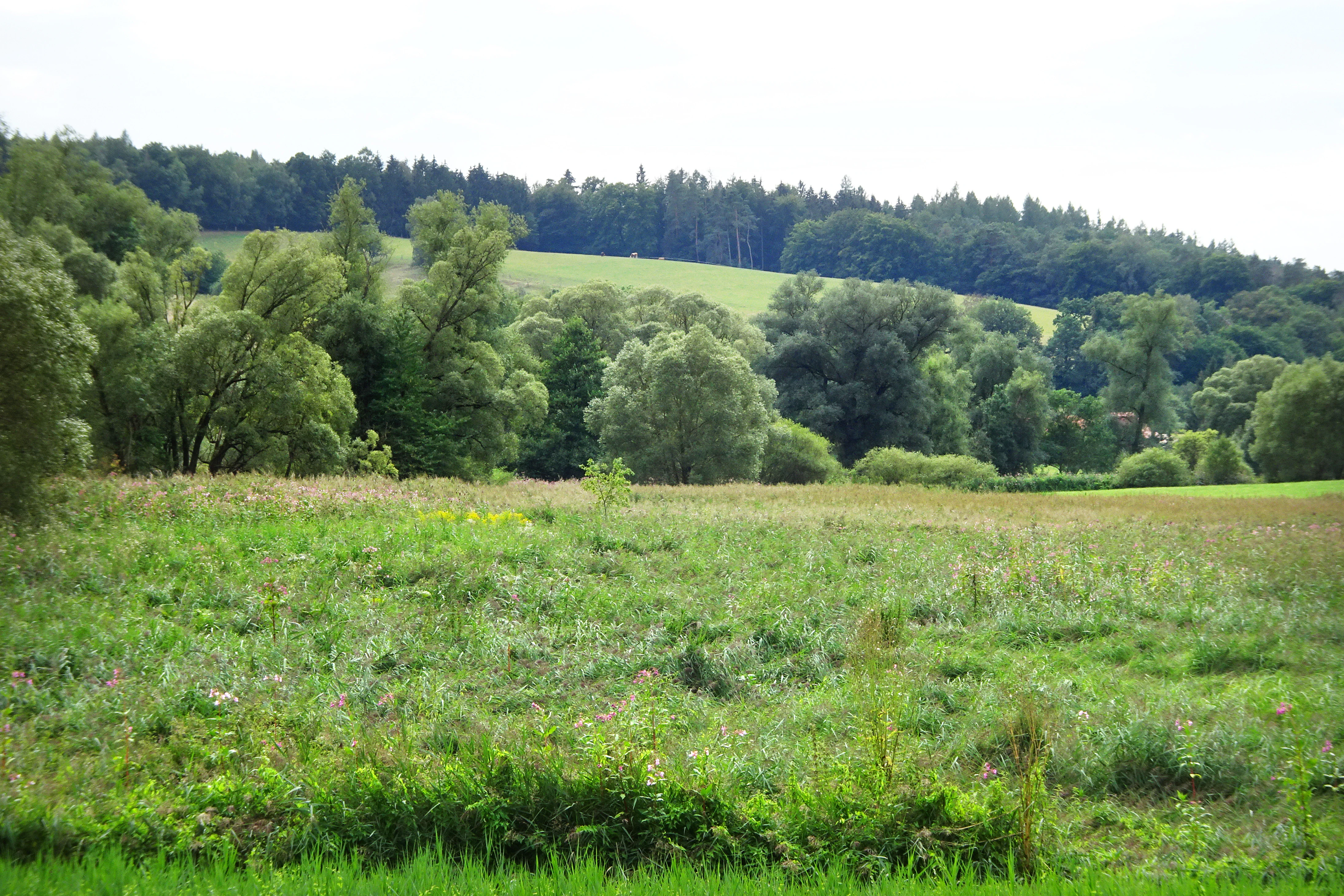
A wide view of a green meadow with wild grasses and small flowers, bordered by a dense line of deciduous trees and a hilly forest background.
The wetlands and meadows of Auf dem Ried bei Iba nature reserve.

Auf dem Ried bei Iba history and protected-area timeline

The name "Auf dem Ried" itself reflects the long wetland character of the area: the German dialect term "Ried" refers to a damp, marshy place where reed grasses grow, suggesting that the floodplain has been recognized as wet ground for centuries. Before modern drainage, the springs, the brook, and the millrace channels all contributed to a persistently high water table. At that time, the coarse grasses of the area were only useful as stable litter (Einstreu) for farm animals.

In the 1930s, drainage channels were cut through the floodplain, allowing more intensive agricultural use of the meadow land. The drainage infrastructure began to fail in 1967, when a long-distance gas pipeline was laid through the area and disrupted the ditches, allowing former wet areas to reflood. Around the same time, many local farms gave up marginal parcels, which then lay fallow. Volunteer and professional conservationists began acquiring or leasing these fallow fields in the mid-1980s, creating small pools and ponds, dismantling redundant drainage ditches, and reopening former channels.

These restoration efforts led directly to the legal protection of the area. By ordinance of 26 November 1985, issued by the regional authority for forestry and nature conservation in Kassel, the wet meadow and reed complex southwest of Iba was officially designated as the nature reserve "Auf dem Ried bei Iba." The stated purpose was to secure the wet area long-term as habitat for endangered plant and animal species and to improve it through management measures. Under the management regime that followed, the state of Hesse acquired almost all of the grassland, and contract farmers continue to maintain the meadows extensively, refraining from fertilizer and plant-treatment products and delaying mowing until mid-June to protect ground-nesting birds and rare plants.

Auf dem Ried bei Iba landscape and geographic character

The landscape of Auf dem Ried bei Iba is defined by a narrow, gently sloping valley floor carved by the Iba brook, a small lowland stream in the eastern Hesse hill country. The reserve occupies only the wettest core of this valley, surrounded by farmland and pasture on slightly higher, better-drained slopes. The protected area sits close to 240 meters above sea level, just above the village of Iba and the historic Ibaer Grundmühle mill, whose millrace still cuts through the eastern part of the site.

Within this small footprint, the topography is shaped almost entirely by water. Springs rise from the valley sides and mix with the brook's flow, while a network of ditches and the millrace channel the water across and through the meadow plain. The result is a shallow, waterlogged basin studded with small ponds, sluggish ditches, and dense reed thickets. To the east and south the terrain opens into drier meadows, while the northern and central portions are dominated by tall reed and wet woodland fringes of black alder and crack willow along the embankments.

The wider visual context is the gently undulating Iba hill country, a transitional landscape between the Solztrottenwald woodland to the south and east and the broader Fulda-Werra uplands. Although the reserve itself is not scenically dramatic, its contrast with the surrounding intensively farmed fields gives it a quiet, almost enclosed character, framed by hedgerows, scattered trees, and the distant wooded ridges of the eastern Hesse highlands.
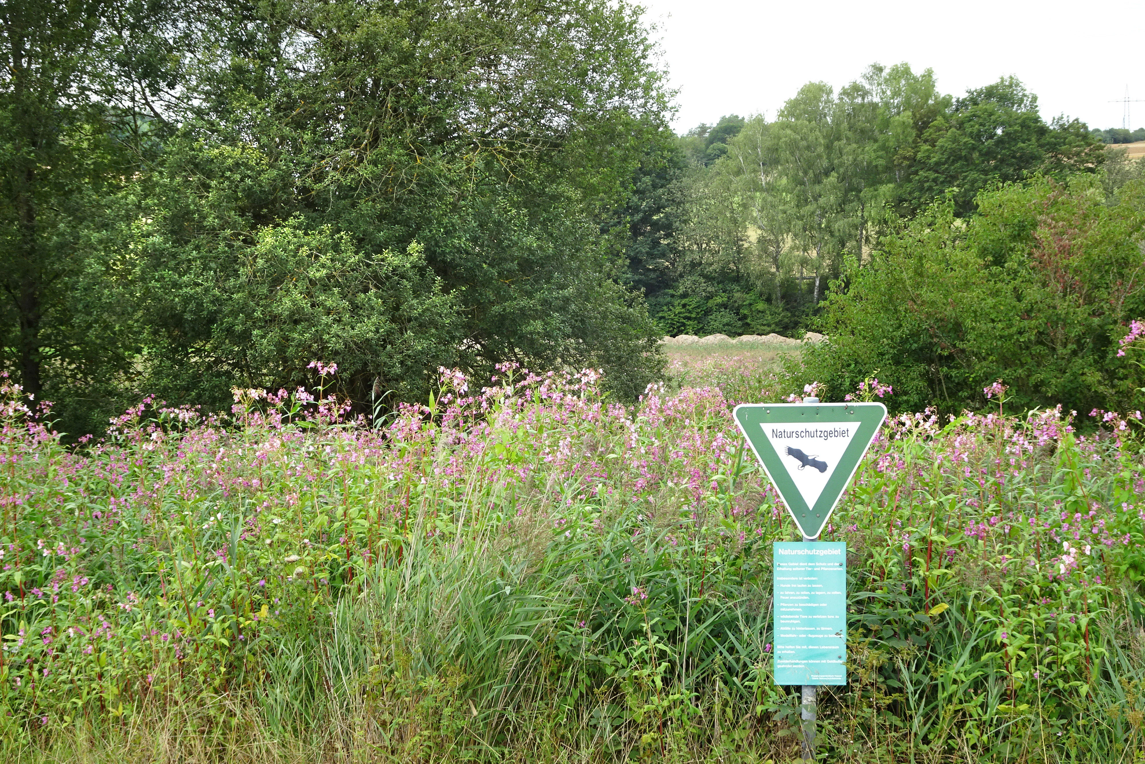
A triangular German nature reserve sign featuring an eagle icon stands in a field of tall grass and wildflowers near a wooded area.
A nature reserve sign marks the entrance to the Auf dem Ried bei Iba protected area.

Auf dem Ried bei Iba ecosystems, habitats, and plant life

Ecologically, Auf dem Ried bei Iba functions as a small but unusually complete mosaic of wet grassland communities and reedbed habitats typical of the Central European lowland and hill-country brook valleys. Although the whole reserve is only a few hectares in size, it contains a surprising range of plant communities arranged along a gradient from drier meadow to permanently waterlogged reed.

In the south, the meadows belong to the widespread tall oatgrass (Glatthaferwiesen) type, while small seepage patches support marsh marigold and soft-rush wet meadows with marsh thistle. Along temporarily flooded ground, creeping foxtail flood meadows form characteristic low swards. Closer to the brook, a butterbur fringe occupies the damper bank zones, and a small bulrush reed stands where a spring-fed channel enters the Iba. The brook banks and the millrace are lined with black alder and crack willow, while the northern part of the reserve and the central corridor between brook and millrace have been increasingly colonized by common reed (Schilfrohr), which has expanded onto former mown wet meadows since the site was protected.

As the protection order notes, the reed zone along the Iba brook is recognized as a biotope of special significance under German federal and Hessian nature conservation law, and the broader wet grassland complex is regarded as a regionally characteristic element of the landscape that plays an important role in local biotope connectivity.
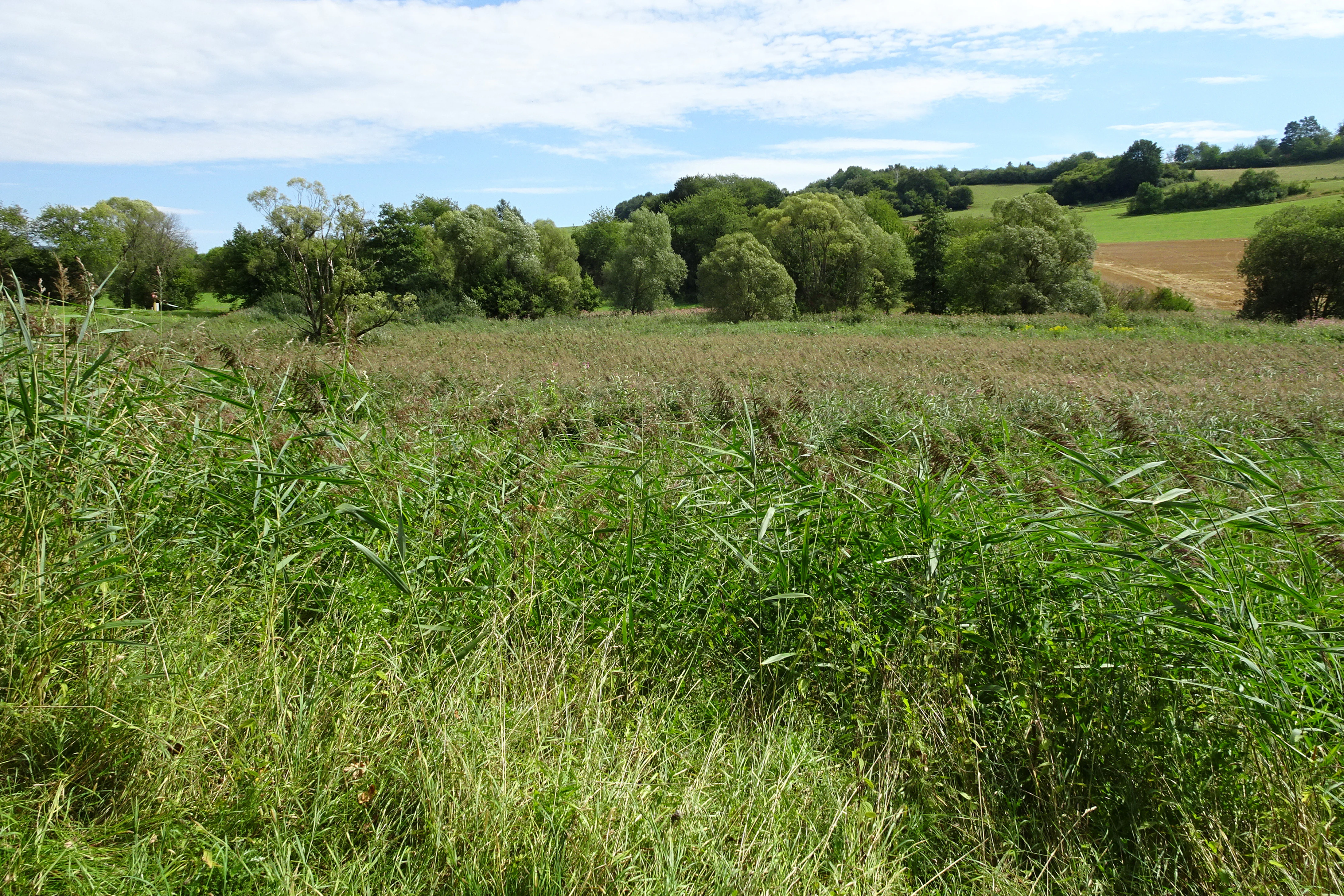
A wide view of a wetland meadow filled with grasses and reeds, with a line of trees and rolling hills in the background under a partly cloudy sky.
The wetland landscape at the Auf dem Ried bei Iba nature reserve in Hesse, Germany.

Auf dem Ried bei Iba wildlife and species highlights

The wildlife profile of Auf dem Ried bei Iba is dominated by birds typical of reedbeds, wet meadows, and small open waters. More than 60 bird species have been recorded in the reserve, of which roughly 20 are listed as threatened in the relevant German Red Lists. The site therefore functions as a disproportionately important refuge for marshland and wet-meadow avifauna within the otherwise largely agricultural Iba valley.

The reedbeds around the small ponds and along the brook support regular breeding populations of moorhen, water rail, reed warbler, and reed bunting. As reed has expanded following the cessation of intensive mowing, some of the formerly common wet-meadow breeders such as snipe and whinchat have largely disappeared from the site. The reserve is also used by winter visitors and passage migrants, including Eurasian teal, jack snipe, bearded reedling, and, more occasionally, meadow pipit and water pipit.

Beyond birds, the combination of springs, ponds, ditches, and unmanaged wet grassland provides habitat for amphibians, invertebrates, and small mammals associated with marshland environments, although the most clearly documented fauna in the source material remains the breeding and migrant bird community.

Auf dem Ried bei Iba conservation status and protection priorities

Auf dem Ried bei Iba is protected primarily because it represents one of the last remaining valley-bottom wet meadow and reed complexes in the Fulda-Werra uplands where spring water still feeds the brook in significant quantity. By shielding this small area from further drainage, fertilization, and intensive mowing, the reserve maintains a functioning example of a habitat type that has almost entirely vanished from the surrounding agricultural landscape.

The 1985 protection order specifically prohibits the use of fertilizers and plant-treatment products, and restricts mowing before 15 June so that ground-nesting birds and rare plant species can complete their breeding cycle. Extensive agricultural use, however, is explicitly permitted as part of the conservation strategy; nearly all grassland has been acquired by the state of Hesse and is maintained under contract by farmers, ensuring that open, species-rich swards and reed margins are preserved rather than allowed to scrub over completely. Small ponds and pools have been created as part of ongoing habitat restoration, and redundant drainage features have been deliberately decommissioned to restore natural water tables.

Beyond its local importance, the reserve is recognized as a component of a wider biotope network in eastern Hesse. The reed zone along the Iba brook is classified as a biotope of special significance under the German Federal Nature Conservation Act and the Hessian implementing act, and the site contributes to regional connectivity between other protected wet habitats in the district of Hersfeld-Rotenburg.

Auf dem Ried bei Iba cultural meaning and human context

The cultural context of Auf dem Ried bei Iba is closely bound to the traditional rural land use of the Iba valley. The very name of the site preserves an old dialect word for a damp, marshy place where reed grasses once grew, indicating that local communities long recognized the wet character of the floodplain. Historically, the coarse reed grasses of the area were cut for use as stable litter rather than as feed, illustrating the practical relationship between local farming systems and the wet meadows.

The presence of the historic Ibaer Grundmühle and its millrace, which still runs along the eastern edge of the reserve, shapes the hydrology and visible structure of the landscape. Former drainage efforts in the 1930s and the later disruption caused by pipeline construction in 1967 also reflect the layered history of human intervention into this small valley. Today's land management, in which the state of Hesse contracts farmers to maintain extensive meadow use, represents a continuation of this traditional agricultural relationship, now adapted explicitly to conservation ends.

Top sights and standout views in Auf dem Ried bei Iba

Auf dem Ried bei Iba stands out for the unusual compactness of its ecological value: in just a few hectares it preserves a complete gradient of meadow, marsh, and reed habitats that mirror the classic wet valley-bottom landscapes once common across eastern Hesse. Its spring-fed hydrology sets it apart from many other meadow reserves in the region.

The reserve's reedbeds and wet meadows support a rich breeding and migrant bird community for their size, including water rail, reed warbler, and bearded reedling, and serve as a refuge for more than twenty Red List species. Combined with a practical management regime under contract farmers and an interpretive panel at the site entrance, it functions as a good example of small-scale wetland conservation within a working agricultural landscape.

Best time to visit Auf dem Ried bei Iba

There are no published monthly guidelines for visiting Auf dem Ried bei Iba, and the reserve is primarily a quiet habitat for walking and observation rather than a developed visitor destination. Broadly, late spring and early summer, after the protected mowing date of 15 June, tend to bring out the richest mix of flowering wet-meadow plants and active breeding birds in the reedbeds.

Autumn and winter can also be rewarding for birdwatchers interested in passage waterfowl and winter visitors drawn to the unfrozen springs and pools. Throughout the year, visitors are guided to view the reserve from the surrounding agricultural tracks rather than entering the meadows themselves, which keeps disturbance low and ensures the seasonal character of the habitat remains intact.

Monthly climate preview

Long-term representative point measurements tracking monthly temperature and precipitation variation

Auf dem Ried bei Iba Climate Normals and Measured Annual Temperature Rhythm

Representative coordinate data records average temperatures ranging from negative values in winter months to over thirty degrees in peak periods, alongside steady daily precipitation across the year. Reviewing these multi-year climate normals provides essential baseline context for the protected area geography without relying on short-term forecasts.
Annual mean8 °C
-1 °C18 °C
Jan-1°
Feb
Mar
Apr
May12°
Jun16°
Jul18°
Aug18°
Sep14°
Oct
Nov
Dec
Warmest month
July

18.3 °C

Coolest month
January

-1.1 °C

Wettest month
July

2.6 mm/day

Driest month
April

1.4 mm/day

Park location guide

Geography guide, regional context, and park location map for Auf dem Ried bei Iba

Auf dem Ried bei Iba park geography, regions, and map view in Germany

Understand where Auf dem Ried bei Iba sits in Germany through a broader geographic reading of the surrounding landscape, nearby location context, and its mapped position within the national park landscape.

How Auf dem Ried bei Iba fits into Germany

Germany is a federal republic in Western and Central Europe with a population of over 83 million across sixteen constituent states. It is Europe's largest economy by nominal GDP and a major global exporter and importer. The capital is Berlin, and the country borders Denmark, Poland, Czech Republic, Austria, Switzerland, France, Luxembourg, Belgium, and the Netherlands.

Wider geography shaping Auf dem Ried bei Iba in Germany

Germany is located in Western and Central Europe, spanning 357,022 km². It borders Denmark to the north, Poland and the Czech Republic to the east, Austria and Switzerland to the south, and France, Luxembourg, Belgium, and the Netherlands to the west. The country has coastlines on the Baltic Sea and North Sea to the north, with the Alps located in the southern region.

Map view of Auf dem Ried bei Iba

Use this park location map to pinpoint Auf dem Ried bei Iba in Germany, understand its exact geographic position, and read its mapped placement within the surrounding landscape more clearly.

Pigeon | © OpenStreetMap contributors

Location context for Auf dem Ried bei Iba

Hesse

Visualizing the spring-fed wetlands, reedbeds, and protected valley habitats

Auf dem Ried bei Iba Landscape and Scenery Photography

Examine detailed photographs capturing the unique wetland terrain, spring-influenced brook corridors, and dense reedbeds of Auf dem Ried bei Iba. Visual documentation reveals the distinct ecological character and preserved meadow habitats defining this protected valley landscape.

A wide view of a green meadow with wild grasses and small flowers, bordered by a dense line of deciduous trees and a hilly forest background.

A green, lush meadow and wetland area at Auf dem Ried bei Iba, with tall wild vegetation, blooming wildflowers, and a line of trees in the background.

A triangular German nature reserve sign featuring an eagle icon stands in a field of tall grass and wildflowers near a wooded area.

A wide view of a wetland meadow filled with grasses and reeds, with a line of trees and rolling hills in the background under a partly cloudy sky.

Park atlas

Compare nearby valley wetland reserves, brook habitats, and regional protected terrain.

Explore Other Parks Near Auf dem Ried bei Iba and Surrounding Protected Landscapes

Browse protected areas and wetland reserves adjacent to Auf dem Ried bei Iba to examine similar valley-bottom habitats across the regional hill country. Continuing through surrounding park geography helps place local spring-fed ecosystems into a wider conservation context.
A soft, minimalist watercolor illustration showing a rolling green landscape with distant hills and patches of pink and yellow vegetation.
Nature reserveHessen
About 0.6 km away#1 closest

Southeast

Dachsberg bei Iba Nature Reserve: Protected Landscapes and Geography in Hessen

Rare calcareous dry grasslands and juniper heath terrain

Located in the Ibaer Hügelland of northeastern Hessen, Dachsberg bei Iba encompasses 27 hectares of lime-rich, shallow-soil slopes. This nature reserve provides essential habitat for threatened orchids and invertebrates, serving as an important example of a traditional cultural landscape preserved through ongoing conservation efforts and historical pastoral land use.

Area
0.271 km²
Established
1993
IUCN
IV
A soft, painterly watercolor landscape showing a green grassy meadow beside a calm lake with a stand of trees and rolling hills in the background.
Nature reserveLandkreis Hersfeld-Rotenburg
About 5.8 km away#2 closest

West

Forbachsee bei Bebra Nature Reserve: Mapped Protected Landscape in Landkreis Hersfeld-Rotenburg

River-connected gravel-pit lake and floodplain geography

Analyze the protected boundaries of Forbachsee bei Bebra, a nature reserve defined by its active connection to the River Fulda. The site features an evolving shoreline of gravel banks and softwood forest, showcasing how industrial extraction areas mature into essential refuges for migratory waterbirds within the larger regional valley system.

Area
0.219 km²
Established
1985
IUCN
IV
Relief
Lowland
Watercolor painting of a river landscape with lush green vegetation and soft pink hills in the background.
Nature reserveLandkreis Hersfeld-Rotenburg
About 5.9 km away#3 closest

Southwest

Alte Fulda bei Blankenheim Nature Reserve: Mapping the Fulda Valley Floodplain Ecosystem

Protected riparian landscapes in Landkreis Hersfeld-Rotenburg

Alte Fulda bei Blankenheim is a vital nature reserve featuring a restored oxbow, wet meadows, and secondary flood channels. This site showcases the intersection of traditional land management and modern wetland conservation within the broader landscape of the Fulda valley. Explore the boundaries, terrain, and regional geography of this important Hessian bird sanctuary and floodplain habitat.

Area
0.236 km²
Established
1981
IUCN
IV
Relief
Lowland
A soft, impressionistic watercolor painting of a serene landscape featuring rolling green hills, lush vegetation, and a calm, reflective lake in the foreground.
Nature reserveHesse
About 7.2 km away#4 closest

Southwest

In den Weiden bei Blankenheim: A Protected Wetland Sanctuary in the Hessian Fulda Valley

Mapping riparian floodplains and bird migration corridors in central Germany.

The In den Weiden bei Blankenheim nature reserve preserves a compact yet ecologically dense floodplain lake environment. Managed as a crucial component of the regional Fulda valley river corridor, it demonstrates the successful conversion of post-industrial gravel pits into a stable habitat for waterbirds, songbirds, and diverse riparian flora within the Hessian landscape.

Area
0.045 km²
Established
1983
IUCN
IV
Relief
Lowland
Nature reserveThuringia
About 8.5 km away#5 closest

Northeast

Werra-Aue zwischen Breitungen und Creuzburg: Protected Floodplain and River Geography

Nature reserve sanctuary in western Thuringia

Spanning over 33 kilometers of the Werra river, this protected floodplain is defined by its distinctive geological sinkholes, seasonal wetlands, and diverse bird habitats. Discover the layered conservation status and riparian terrain that mark this significant Thuringian nature reserve as a crucial node for European ecological connectivity.

Area
25.78 km²
Established
2007
IUCN
IV
Relief
Lowland
A horizontal watercolor painting showing a soft landscape with green meadows, trees, a winding stream, and distant rolling hills in a light, atmospheric style.
Nature reserveHessen
About 9.4 km away#6 closest

Southeast

Säulingssee Nature Reserve: Atlas Overview of this Hessen Protected Wetland Basin

Mapped geography and landscape context of a unique German reserve

Säulingssee serves as an important nature reserve within the Werra valley region of Hessen. This former lake basin now acts as a sophisticated wetland complex featuring subrosion-driven pools, reedbeds, and varied meadow habitats. As part of the Natura 2000 network and the Grünes Band Hessen corridor, the area offers a significant case study for conservation grazing and the restoration of endangered aquatic plants within Germany.

Area
0.214 km²
Established
1984
IUCN
IV
Relief
Lowland
A soft watercolor illustration of a calm pond surrounded by green vegetation and rolling hills in the background.
Nature reserveWartburgkreis
About 11 km away#7 closest

East

Dankmarshäuser Rhäden: Protected Wetland Reserve and Mapped Floodplain in Wartburgkreis

Restored basin landscape along the historic Green Belt corridor.

Dankmarshäuser Rhäden comprises a complex wetland mosaic in the Wartburgkreis district. This nature reserve, characterized by shallow subsidence basins and active floodplain management, represents a critical migratory bird sanctuary and a key component of the protected Green Belt. The area reveals a history of land-use transition, from agricultural depression to a functional, water-managed ecosystem supporting diverse meadow-nesting and migratory bird populations.

Area
1.217 km²
Established
1995
IUCN
IV
A soft watercolor illustration depicting a flat green wetland landscape with a winding river and distant rolling hills under a pale sky.
Nature reserveHesse
About 11 km away#8 closest

East

Rhäden bei Obersuhl und Bosserode: Nature Reserve and Wetland Mosaic in Northern Hesse

A restored floodplain landscape in the Werra valley

Rhäden bei Obersuhl und Bosserode represents a significant subsidence basin restored from agricultural land into a thriving wetland. This protected nature reserve in Hesse features a structured mosaic of ponds, reedbeds, and wet meadows, serving as a primary regional site for bird migration and habitat conservation within the Werra valley geography.

Area
1.204 km²
Established
1973
IUCN
IV
Relief
Lowland

Common questions about visiting, size, designation, and location context for Auf dem Ried bei Iba

Auf dem Ried bei Iba FAQs for park facts, access, geography, and protected area context

Find quick answers about Auf dem Ried bei Iba, including protected-area facts, park geography, trail and visitor context, and how the park fits into its surrounding country and regional landscape.
MoriAtlas Explorer

Continue Your Protected Areas Search Across the Global Atlas

Deepen your exploration by continuing the structured search for national parks and protected areas worldwide. Utilize the comprehensive filtering capabilities to compare different conservation landscapes and refine your understanding of global park geography. Discover more about the distribution and characteristics of protected natural areas.

Global natural geography