Mori Atlas logo
Nature reserveBarrengarry Nature Reserve

Examining the ecological mosaic of warm temperate rainforest and eucalyptus forest hinterlands.

Barrengarry Nature Reserve: Protected Landscape and Regional Geography of New South Wales

Located in the Illawarra hinterland near Kangaroo Valley, Barrengarry Nature Reserve serves as a compact 21-hectare refuge of critical ecological heterogeneity. The site documents the transition between sheltered warm temperate rainforest and expansive eucalyptus forest, providing essential habitat within the regional reserve network of New South Wales. This protected area highlights how small, intact landscapes contribute to biodiversity and structural terrain complexity in the coastal escarpment region.

strict nature reservewarm temperate rainforesteucalyptus forestIllawarra regionthreatened species habitatsmall protected area

Barrengarry Nature Reserve

Nature reserve

Park overview

Structured park overview, official facts, and landscape profile for Barrengarry Nature Reserve

Barrengarry Nature Reserve park facts, protected area profile, and essential visitor context

Review the core facts for Barrengarry Nature Reserve, including designation, size, terrain, visitor scale, habitats, and operating context in one park-focused overview.

About Barrengarry Nature Reserve

Barrengarry Nature Reserve is a tightly defined protected area located in the settlement of Barrengarry, within the broader Illawarra region of New South Wales. With an area of about 21 hectares, it is a small reserve, but its ecological purpose is sharply focused. The reserve exists to conserve two forest formations that together characterise much of the surrounding hinterland: warm temperate rainforest and eucalyptus-dominated forest.

The reserve sits in the landscape around Kangaroo Valley, a region long appreciated for its scenic rural character and proximity to the Illawarra escarpment. This setting places Barrengarry within a transitional zone between coastal and inland environments, where moisture, soils, and topography produce a varied mosaic of vegetation types. Within the reserve, rainforest patches occupy sheltered, humid microenvironments, while eucalyptus forest extends across more exposed slopes, reflecting the contrast between wet gullies and drier ridges.

What makes the reserve especially significant is its role in sustaining populations of threatened species. The presence of the eastern bristlebird, a rare and range-restricted songbird; the brush-tailed rock-wallaby, emblematic of rocky escarpment habitats; and the long-nosed potoroo, a small ground-dwelling marsupial, indicates that the reserve provides high-quality habitat for fauna that are under pressure elsewhere in the region.

Managed by the NSW National Parks and Wildlife Service and classified as an IUCN Category Ia strict nature reserve, Barrengarry is part of New South Wales' system of strongly protected sites that prioritise ecological integrity. Although it is small in size, it functions as an important contributor to local biodiversity conservation and as a complement to larger national parks and state forests in the Illawarra and Southern Highlands transition zone.

Quick facts and research context for Barrengarry Nature Reserve

Barrengarry Nature Reserve covers about 21 hectares in the Illawarra region of New South Wales, lying near the community of Barrengarry and the nearest town of Kangaroo Valley. It was formally established on 1 January 2001 and is classified as an IUCN Category Ia strict nature reserve, indicating a high level of protection.

The reserve is administered by the NSW National Parks and Wildlife Service. Its defining purposes are the protection of rainforest communities and eucalyptus forest, along with habitat for several threatened species. The reserve sits within a region historically recognised for its biodiversity-rich escarpment and hinterland environments.

Protection and recognition

Documented terrestrial protection scope and international recognition details

Barrengarry Nature Reserve Protection Status and Governance Data

Barrengarry Nature Reserve maintains a documented terrestrial protection scope without imported international recognition sources. Reviewing these conservation records provides clear context on the administrative framework governing the protected area.

Protection details

Protection scope
Terrestrial
Transboundary protection
No
Park context

Deeper park guide and search-rich context for Barrengarry Nature Reserve

Barrengarry Nature Reserve history, landscape, wildlife, and travel context

Explore Barrengarry Nature Reserve through its history, landscape character, ecosystems, wildlife, conservation priorities, cultural context, and seasonal travel timing in a structured park guide built for atlas discovery and search intent.

Why Barrengarry Nature Reserve stands out

Barrengarry Nature Reserve is best known for protecting a compact patch of warm temperate rainforest alongside eucalyptus forest in the Illawarra hinterland of New South Wales. Its conservation value comes from the coexistence of these two forest types in a very small area, creating rich habitat heterogeneity. The reserve is also recognised for supporting populations of threatened species such as the eastern bristlebird, the brush-tailed rock-wallaby, and the long-nosed potoroo, making it a small but disproportionately important refuge within the regional reserve network.
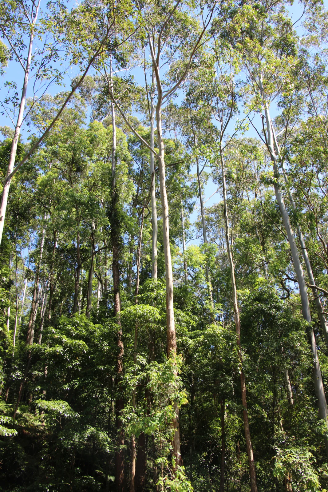
A low angle view looking up at a dense forest canopy dominated by tall, slender eucalyptus trees with light colored trunks against a blue sky.
Tall eucalyptus trees forming part of the forest canopy in Barrengarry Nature Reserve.

Barrengarry Nature Reserve history and protected-area timeline

Barrengarry Nature Reserve was formally established on 1 January 2001, when it was added to New South Wales' system of protected areas managed by the NSW National Parks and Wildlife Service. Its creation reflected growing recognition of the importance of conserving small but ecologically significant patches of forest in the Illawarra region.

The reserve's establishment was driven by the need to safeguard warm temperate rainforest and eucalyptus forest communities, as well as habitat for threatened species such as the eastern bristlebird, brush-tailed rock-wallaby, and long-nosed potoroo. Its IUCN Category Ia classification, as a strict nature reserve, signals that management emphasis has been placed on preserving natural ecological processes and biodiversity rather than on providing for public recreation.

Barrengarry Nature Reserve landscape and geographic character

The landscape of Barrengarry Nature Reserve is shaped by the broader geography of the Illawarra hinterland, where coastal escarpment influences meet inland rolling terrain. The reserve lies near Kangaroo Valley, an area known for its combination of steep ridges, sheltered gullies, and pastoral valleys.

Within its 21 hectares, the reserve presents a mosaic of physical conditions that supports different vegetation communities. Sheltered, moister pockets support warm temperate rainforest, with dense canopy cover and humid microclimates. Adjacent slopes and ridges, more exposed to sun and wind, support eucalyptus forest, with a more open character and a ground layer of native grasses, shrubs, and leaf litter. The transition between these two environments is a defining feature of the reserve's landscape.

Barrengarry Nature Reserve ecosystems, habitats, and plant life

Ecologically, Barrengarry Nature Reserve is significant for the coexistence of warm temperate rainforest and eucalyptus forest communities within a compact area. This juxtaposition of forest types creates strong habitat heterogeneity and contributes to the reserve's importance for biodiversity conservation in the Illawarra region.

The rainforest communities are likely to include characteristic species of the region's warm temperate forests, such as sassafras, native beech, soft tree ferns, and a shaded understorey of ferns and mosses. The eucalyptus forest, in contrast, supports a more open habitat structure with a diverse ground flora. Together, these vegetation communities provide the structural diversity required to sustain many different forms of wildlife, from canopy-dwelling birds to ground-active mammals.

Barrengarry Nature Reserve wildlife and species highlights

Barrengarry Nature Reserve plays a meaningful role in supporting populations of threatened wildlife in the Illawarra region. Three species of particular conservation concern are documented as occurring within the reserve: the eastern bristlebird, the brush-tailed rock-wallaby, and the long-nosed potoroo.

The eastern bristlebird is a shy, ground-loving songbird whose range has contracted across southeastern Australia. Its presence at Barrengarry suggests that the reserve provides dense, low vegetation suitable for its survival. The brush-tailed rock-wallaby, characteristic of rocky escarpment environments, benefits from the structural complexity of the local terrain and vegetation. The long-nosed potoroo, a small marsupial related to kangaroos, depends on areas with thick understorey for shelter and foraging.

Beyond these headline species, the mix of rainforest and eucalyptus forest is likely to support additional native fauna typical of the region, including various forest birds, small marsupials, reptiles, and invertebrates, although detailed records are not provided in the source material.

Barrengarry Nature Reserve conservation status and protection priorities

The principal conservation significance of Barrengarry Nature Reserve lies in its protection of warm temperate rainforest and eucalyptus forest communities within a single, compact site. By securing this forest mosaic, the reserve contributes to the retention of habitat connectivity and ecological diversity in the Illawarra hinterland.

Its IUCN Category Ia status indicates that the reserve is managed primarily for biodiversity protection and ecological integrity. This high level of protection reflects recognition of the reserve's importance for threatened species such as the eastern bristlebird, brush-tailed rock-wallaby, and long-nosed potoroo. Although small, the reserve therefore forms part of the broader safety net of protected sites that collectively support the persistence of species and ecological communities in New South Wales.

Top sights and standout views in Barrengarry Nature Reserve

The reserve's most distinctive feature is the presence of warm temperate rainforest alongside eucalyptus forest within a very compact 21-hectare area. This juxtaposition creates powerful habitat heterogeneity in a single small protected site.

Another major highlight is the documented presence of threatened species, including the eastern bristlebird, brush-tailed rock-wallaby, and long-nosed potoroo. These species underscore the reserve's role as a meaningful refuge within the regional ecological network, despite its small size.

Best time to visit Barrengarry Nature Reserve

Because Barrengarry Nature Reserve is a strict nature reserve with an emphasis on ecological protection rather than visitor access, the practical opportunities for general public visitation are limited, and detailed seasonal access guidance is not strongly supported by available sources. Generally, periods of mild and dry weather typical of spring and autumn in the Illawarra hinterland are well suited to observing forest landscapes and bird activity across the region, but visitors should rely on official NSW National Parks and Wildlife Service guidance for current conditions or access arrangements.


Monthly climate preview

Long-term temperature ranges and monthly precipitation averages for New South Wales

Barrengarry Nature Reserve Climate Normals and Annual Weather Patterns

Historical climate records outline the measured annual temperature rhythm and monthly precipitation distribution across Barrengarry Nature Reserve. Detailed multi-year data provides complete monthly metrics for examining long-term environmental conditions at a representative coordinate.
Annual mean15 °C
9 °C21 °C
Jan21°
Feb21°
Mar19°
Apr16°
May13°
Jun10°
Jul
Aug10°
Sep13°
Oct15°
Nov18°
Dec20°
Warmest month
January

21.4 °C

Coolest month
July

9.2 °C

Wettest month
February

4.5 mm/day

Driest month
July

1.8 mm/day

Park location guide

Geography guide, regional context, and park location map for Barrengarry Nature Reserve

Barrengarry Nature Reserve park geography, regions, and map view in Australia

Understand where Barrengarry Nature Reserve sits in Australia through a broader geographic reading of the surrounding landscape, nearby location context, and its mapped position within the national park landscape.

How Barrengarry Nature Reserve fits into Australia

Australia is a constitutional monarchy and federal parliamentary democracy comprising six states and ten territories. With a population of nearly 28 million, it is one of the world's most urbanised countries, with most people concentrated on the eastern seaboard. The country has a high Human Development Index and is known for its cultural diversity, ancient Aboriginal heritage, and unique wildlife.

Wider geography shaping Barrengarry Nature Reserve in Australia

Australia occupies the entire Australian continent, the island of Tasmania, and numerous smaller islands. It is the world's flattest and driest inhabited continent, featuring vast deserts in the interior (the Outback), tropical rainforests along the eastern coast, and a coastline bordering the Indian and Pacific Oceans.

Map view of Barrengarry Nature Reserve

Use this park location map to pinpoint Barrengarry Nature Reserve in Australia, understand its exact geographic position, and read its mapped placement within the surrounding landscape more clearly.

Pigeon | © OpenStreetMap contributors

Location context for Barrengarry Nature Reserve

New South Wales

Explore protected habitat views, terrain features, and forest environments in New South Wales

Barrengarry Nature Reserve Photos and Landscape Scenery Visual Guide

Visual documentation captures the unique juxtaposition of warm temperate rainforest and open eucalyptus forest across the reserve. Photographic records reveal the complex terrain and sheltered hinterland microclimates that sustain native species habitats in the Illawarra region.

A low angle view looking up at a dense forest canopy dominated by tall, slender eucalyptus trees with light colored trunks against a blue sky.

Park atlas

Compare regional hinterland reserves and connected conservation areas across New South Wales

Explore Parks Near Barrengarry Nature Reserve and Surrounding Protected Landscapes

Browsing other parks near Barrengarry Nature Reserve reveals the diverse forest communities and rugged escarpment terrain defining the Illawarra region. Extending the conservation scope allows travelers to compare nearby protected areas and examine regional ecological networks.
Watercolor landscape illustration showing green fields, trees, hills, and pastel sky
National parkNew South Wales
About 0.9 km away#1 closest

Southwest

Morton National Park: A Protected Landscape of Waterfalls and Dissected Plateaus in New South Wales

Explore its mapped boundaries and regional geographic context.

Morton National Park is a nationally recognized protected area within New South Wales, Australia, celebrated for its striking natural features and geographic significance. The park's landscape is characterized by a dramatic dissected plateau, giving rise to impressive waterfall systems such as Fitzroy Falls and Belmore Falls that cascade into deep gorges. As a key component of the Southern Highlands' natural heritage, Morton National Park provides a rich subject for atlas exploration, offering insights into regional terrain, protected land distribution, and the unique interplay of natural elements within this Australian national park.

Area
1,997.45 km²
Established
1967
IUCN
II
Relief
Mixed relief
National parkNew South Wales
About 3.6 km away#2 closest

East

Budderoo National Park: Protected Landscape Exploration in New South Wales

Mapping the protected area and its regional geographic context.

Gain a clear understanding of Budderoo National Park as a protected national park situated within New South Wales. This detail page focuses on its mapped geographic features and protected landscape characteristics, providing critical context for atlas-based discovery. Explore the park's position within the broader regional geography of Australia and appreciate its identity as a conservation landscape.

Area
72.19 km²
Established
1986
IUCN
II
Climate
Subtropical
A soft watercolor illustration featuring sparse trees and low-lying scrubland against a hazy, distant horizon.
Nature reserveNew South Wales
About 7.7 km away#3 closest

South

Cambewarra Range Nature Reserve: Geographic Atlas and Protected Landscape Overview

Escarpment forests and plateau terrain in New South Wales

The Cambewarra Range Nature Reserve acts as a resilient ecological anchor within the Southern Highlands, safeguarding coachwood-dominated rainforests and diverse heath shrublands. As part of a larger network of protected lands, its steep terrain and rocky cliffs provide essential habitat for threatened species while managing regional drainage across the Sydney Basin geological landscape.

Area
16.84 km²
Established
2001
Relief
Highland
Climate
Temperate
Nature reserveNew South Wales
About 8 km away#4 closest

Southwest

Kangaroo River Nature Reserve: Protected Valley Landscapes in New South Wales

Mapping rainforest gullies and diverse forest ecosystems

Located in the heart of the Kangaroo Valley, this nature reserve protects a vital ecological corridor of sclerophyll forest and rainforest. Its distinct gully systems and volcanic soil pockets provide essential habitat, serving as a cornerstone of the broader Shoalhaven protected landscape network in southern New South Wales.

Area
1.26 km²
Established
2001
IUCN
Ia
Relief
Upland
Nature reserveNew South Wales
About 12 km away#5 closest

Northeast

Robertson Nature Reserve: Mapping a Rare Rainforest Remnant in the New South Wales Highlands

Protected warm temperate rainforest and escarpment geography

Robertson Nature Reserve serves as a vital conservation anchor in the New South Wales Southern Highlands. This reserve protects a dense fragment of warm temperate rainforest, characterized by its low canopy and rich basaltic soil composition. The area offers an opportunity to study the distinct ecology of the historic Yarrawa Brush and its adaptation to the high rainfall conditions along the Illawarra Escarpment.

Area
0.053 km²
Established
1979
Relief
Upland
Climate
Temperate
National parkAustralia
About 12 km away#6 closest

South

Bugong National Park: Protected Landscape Identity and Geographic Context in Australia

Discover unique biodiversity, forest habitats, and regional terrain.

Bugong National Park stands as a vital strict nature reserve within Australia's protected lands. Its distinct geography features a plateau below the Cambewarra range and steeply sloping valleys carved by waterways like Bugong Creek and the Shoalhaven River. This protected area is crucial for conserving significant biodiversity, including endemic and threatened species, across its diverse wet and dry forest habitats. For those interested in atlas exploration, Bugong National Park offers a clear example of landscape conservation and protected area geography within New South Wales.

Area
10.22 km²
Established
2001
IUCN
Ia
Relief
Mixed relief
National parkNew South Wales
About 16 km away#7 closest

Northeast

Macquarie Pass National Park: National Park Protected Landscape and Regional Geography

Mapped protected area boundaries and natural terrain context.

Macquarie Pass National Park is an important protected natural landscape situated in New South Wales. This page offers an atlas-focused view, detailing the park's precise geographic extent and its significance as a national park. Understanding its mapped boundaries and its position within the regional geography allows for a deeper appreciation of its protected status and the natural terrain it encompasses, serving as a key entry point for geographic discovery.

Area
11 km²
Established
1969
IUCN
II
Relief
Mountain
A watercolor illustration showing a winding river curving through green rolling hills with scattered trees and a soft pastel pink and yellow sky
Nature reserveNew South Wales
About 16 km away#8 closest

East

Barren Grounds Nature Reserve: Sandstone Heath and Escarpment Geography in New South Wales

An essential atlas profile of protected plateaus and bird habitat

Located on the high plateau of the Illawarra escarpment, Barren Grounds Nature Reserve protects a unique landscape of sandy soils, coastal cliff lines, and weathered rock formations. This nature reserve offers a distinct look into the ecological and geological character of the Southern Highlands, serving as a vital bird conservation hub within the New South Wales landscape.

Area
20.24 km²
Established
1956
IUCN
II
Relief
Upland

Common questions about visiting, size, designation, and location context for Barrengarry Nature Reserve

Barrengarry Nature Reserve FAQs for park facts, access, geography, and protected area context

Find quick answers about Barrengarry Nature Reserve, including protected-area facts, park geography, trail and visitor context, and how the park fits into its surrounding country and regional landscape.
MoriAtlas Explorer

Continue Your Protected Areas Search Across the Global Atlas

Deepen your exploration by continuing the structured search for national parks and protected areas worldwide. Utilize the comprehensive filtering capabilities to compare different conservation landscapes and refine your understanding of global park geography. Discover more about the distribution and characteristics of protected natural areas.

Global natural geography