

Mori Atlas logo
Nature reserveBasilan Natural Biotic Area

Mapping the primary and secondary rainforest corridors within this critical island protected landscape

Basilan Natural Biotic Area: An Essential Mountain Forest Reserve in the Philippine Interior

Basilan Natural Biotic Area functions as a mountainous forest refuge and essential hydrological anchor for the interior of Basilan Island in the southern Philippines. Spanning elevations above 1,000 meters, this nature reserve protects a mosaic of primary rainforest on Mount Mohadji alongside extensive secondary forest regrowth. The protected area serves as a primary habitat for endemic bird species and supports the ecological integrity of watersheds across the rugged island terrain.

tropical rainforestprotected forestmountain terrainendemic birdsforest reserveimportant bird area

Basilan Natural Biotic Area

Nature reserve

Park overview

Structured park overview, official facts, and landscape profile for Basilan Natural Biotic Area

Basilan Natural Biotic Area park facts, protected area profile, and essential visitor context

Review the core facts for Basilan Natural Biotic Area, including designation, size, terrain, visitor scale, habitats, and operating context in one park-focused overview.

About Basilan Natural Biotic Area

Basilan Natural Biotic Area is a Philippine protected natural area located on the island of Basilan. The island lies just southwest of the Zamboanga Peninsula of Mindanao, separated from the mainland by a narrow strait, and forms a transitional zone between the biogeographic regions of the Zamboanga Peninsula and the Sulu Archipelago.

The protected area was established through Presidential Proclamation No. 321, signed on May 31, 2000, as part of a larger national effort to safeguard representative forest ecosystems under the Philippines' National Integrated Protected Area System. It encompasses roughly 4,497 hectares of core area surrounded by a buffer zone of about 2,019 hectares, distributed across the municipal jurisdictions of Lamitan City, Sumisip, Tipo-Tipo, and Isabela City.

The reserve's highest elevations exceed 1,000 meters above sea level, and these montane ridges form the heart of the protected area. Around Mount Mohadji a small but ecologically valuable fragment of primary rainforest survives, while much of the surrounding landscape has been shaped by past human activity and now supports extensive secondary rainforest regrowth.

Biogeographically, the reserve is significant because it preserves habitat for a number of bird subspecies that are endemic or near-endemic to Basilan and adjacent parts of Mindanao. The presence of these restricted-range taxa has led BirdLife International to recognize the area as an Important Bird Area, anchoring its conservation profile around tropical rainforest and avian endemism rather than around large charismatic mammals.

Quick facts and research context for Basilan Natural Biotic Area

Basilan Natural Biotic Area is a forest reserve on Basilan Island, the southernmost major island of the Sulu Archipelago chain within the Philippines. It was created in 2000 through Presidential Proclamation No. 321 and covers approximately 4,497 hectares of core forest plus a 2,019-hectar buffer zone.

The terrain consists of steep interior mountains rising above 1,000 meters, where roughly 234 hectares of primary rainforest survive on Mount Mohadji and about 2,500 hectares of secondary rainforest continue across the broader reserve. The site is recognized by BirdLife International as an Important Bird Area and supports endemic and restricted-range subspecies tied to Basilan and Mindanao.

Protection and recognition

Examine official protected area designation records and terrestrial conservation scope.

Basilan Natural Biotic Area Protection Status and International Recognition

Basilan Natural Biotic Area maintains a documented terrestrial protection status with structured records in the global database. Comprehensive administrative facts track administrative definitions and international recognition frameworks for the protected landscape.

Protection details

Protection scope
Terrestrial
Transboundary protection
No
WDPA ID
7226
Buffer area
20.19 km²
Park context

Deeper park guide and search-rich context for Basilan Natural Biotic Area

Basilan Natural Biotic Area history, landscape, wildlife, and travel context

Explore Basilan Natural Biotic Area through its history, landscape character, ecosystems, wildlife, conservation priorities, cultural context, and seasonal travel timing in a structured park guide built for atlas discovery and search intent.

Why Basilan Natural Biotic Area stands out

Basilan Natural Biotic Area is best known for its primary and secondary rainforest patches on Mount Mohadji and for harboring a high concentration of bird subspecies endemic to Basilan and nearby parts of Mindanao. Species of particular note include the Zamboanga bulbul, the Philippine hanging parrot, the Philippine fairy-bluebird, the Mindanao wren-babbler, and a suite of other forest-dependent passerines recorded only in localized forms on the island. The reserve is regarded as a critical forest refuge for the Basilan-Mindanao endemic bird zone, giving it strong ornithological importance even though Basilan itself is a relatively small and geographically isolated island.

Basilan Natural Biotic Area history and protected-area timeline

Basilan Natural Biotic Area was created on May 31, 2000, by Presidential Proclamation No. 321 of the Republic of the Philippines. The proclamation formalized the reserve as part of the country's National Integrated Protected Area System, the framework established by Republic Act 7586 that consolidates the management of the Philippines' protected landscapes and seascapes.

The reserve was designated to protect the remaining primary and secondary rainforest on Basilan Island, much of which had been progressively reduced by logging, agricultural expansion, and settlement pressures on the island over the preceding decades. Placing the mountainous interior of Basilan under a single, integrated biotic-area designation allowed the government to coordinate protection of forest cover, watershed values, and the island's endemic wildlife in one statutory instrument.

Since its designation, the area has been tracked within the World Database on Protected Areas and monitored for its bird values by BirdLife International, reflecting its ongoing role as a recognized conservation site within the Zamboanga Peninsula region.

Basilan Natural Biotic Area landscape and geographic character

Basilan Island's interior is rugged, and the Basilan Natural Biotic Area captures the most mountainous portion of that interior. Elevations within the reserve exceed 1,000 meters, producing steep ridges, deep valleys, and fast-flowing streams typical of the humid tropical terrain where the Sulu Sea meets the Moro Gulf.

Mount Mohadji is the principal peak associated with the reserve and supports the most intact primary rainforest, an ecologically important footprint that contrasts with the broader matrix of secondary forest that has regrown across former disturbance areas on the surrounding slopes. The combination of steep topography, persistent high humidity, and heavy seasonal rainfall shapes a continuous forest cover across the protected area, interrupted mainly by forest disturbance classes rather than by infrastructure or large clearings.

The terrain also serves as the headwaters for several of Basilan's watersheds, with rainwater draining from the high ridges through the reserve before reaching the surrounding lowlands and coastal areas. This makes the park's landscape not only a habitat zone but also a hydrological anchor for much of the island's interior.

Basilan Natural Biotic Area ecosystems, habitats, and plant life

The reserve's ecological character is dominated by tropical rainforest, including both lowland and lower montane formations that track elevation gradients up to the highest ridges above 1,000 meters. Roughly 234 hectares of primary rainforest remain on the slopes of Mount Mohadji, while about 2,500 hectares of secondary rainforest now form the larger vegetation matrix around and between these primary patches.

This vegetation mosaic creates relatively continuous forest cover across a significant portion of Basilan's interior, even though the landscape has clearly been influenced by past human activity. The transition from primary to secondary forest is gradual, supporting a forest-dependent avifauna that can rely on canopy structure, fruiting trees, and understory complexity rather than on pristine old-growth conditions alone.

The combination of rainfall, elevation, and forest cover makes the area a key refugium for the island's forest biodiversity, especially for birds that depend on interior rainforest rather than edge habitats or lowland coastal woodland.

Basilan Natural Biotic Area wildlife and species highlights

Wildlife around Basilan Natural Biotic Area is best documented through its avifauna, which is the primary reason the site has been recognized internationally as an Important Bird Area. Several bird taxa recorded here are endemic to Basilan or shared only with restricted portions of neighboring Mindanao, giving the reserve a disproportionate ornithological value relative to its modest size.

Key species and subspecies documented include the Zamboanga bulbul, which is endemic to Basilan, along with the Philippine hanging parrot subspecies found on the island, the Philippine fairy-bluebird in its distinctive dark-backed Mindanao-Basakan form, and the Mindanao wren-babbler in its Basilan subspecies. Other regularly recorded forest passerines include the striped tit-babbler, the Philippine tailorbird in its Basilan form, the rufous-tailed jungle flycatcher, the Philippine whistler in its Basilan subspecies, and the white-throated spiderhunter in its Basilan form.

Altogether, the reserve supports a community of rainforest birds tied to closed-canopy habitat, with very limited overlap with the drier or more open habitats found elsewhere on Basilan or the surrounding Sulu Sea islands. This makes the area one of the most important strongholds for forest-dependent birds in the southern Philippines.

Basilan Natural Biotic Area conservation status and protection priorities

Conservation significance for Basilan Natural Biotic Area lies primarily in its role as a refuge for the Basilan-Mindanao endemic bird zone and as one of the larger contiguous forest blocks remaining on Basilan Island itself. Its recognition by BirdLife International as an Important Bird Area reflects the concentration of restricted-range bird subspecies recorded within its boundaries.

The reserve also contributes to watershed protection across much of Basilan, since the forests above 1,000 meters on Mount Mohadji and the surrounding ridges feed streams that sustain agriculture and settlements on the lower slopes and coastal fringes. Preserving these forests therefore has direct implications for water supply, erosion control, and the resilience of lowland land use systems on the island.

Basilan Natural Biotic Area cultural meaning and human context

Basilan has a longstanding cultural identity shaped by its position at the edge of the Sulu Archipelago, with deep historical connections between the island's Yakan, Tausug, and Chavacano-speaking communities, and broader trade and religious networks linking the southern Philippines to maritime Southeast Asia.

The mountainous interior where the protected area sits has historically served as a relatively sparsely settled zone compared with the island's coastal lowlands, in part because of the steep terrain and limited agricultural potential. This has helped preserve forest cover that supports the reserve today, even as population growth, agriculture, and infrastructure pressures on the island have intensified in recent decades.

Top sights and standout views in Basilan Natural Biotic Area

Basilan Natural Biotic Area stands out as one of the few formally designated, high-elevation forest reserves on Basilan Island and as a recognized Important Bird Area for endemic and restricted-range bird subspecies.

Highlights include roughly 234 hectares of primary rainforest on Mount Mohadji, around 2,500 hectares of secondary rainforest across a broader 4,497-hectar core area, and a 2,019-hectar buffer zone. The site anchors protection for the Basilan-Mindanao endemic bird zone within the Zamboanga Peninsula region.

Best time to visit Basilan Natural Biotic Area

The reserve sits in a humid tropical climate with rainfall distributed across much of the year, so conditions in the interior forests are typically wet and lush at most times. Periods of relatively drier weather can make trail conditions and overall accessibility more favorable, while the rainy season can intensify stream flow, muddiness on forest paths, and general humidity under the canopy.

For visitors focused on birdwatching, mornings tend to offer the strongest bird activity within closed-canopy rainforest, regardless of season. Anyone planning a visit should keep in mind that the high-elevation interior remains a remote and rugged environment, and broader considerations of regional security and access in parts of Basilan have historically affected practical visits as much as weather patterns.

Monthly climate preview

Long term temperature and monthly precipitation averages for Basilan

Basilan Natural Biotic Area Climate Normals and Annual Weather Patterns

Basilan Natural Biotic Area records consistent monthly average temperatures alongside shifting precipitation totals across the representative coordinate dataset. Examining the complete twelve month climate profile reveals detailed fluctuations in long term weather norms.
Annual mean28 °C
27 °C28 °C
Jan27°
Feb27°
Mar28°
Apr28°
May28°
Jun28°
Jul27°
Aug27°
Sep27°
Oct28°
Nov28°
Dec28°
Warmest month
May

28.1 °C

Coolest month
January

27.3 °C

Wettest month
October

6.1 mm/day

Driest month
March

2.5 mm/day

Park location guide

Geography guide, regional context, and park location map for Basilan Natural Biotic Area

Basilan Natural Biotic Area park geography, regions, and map view in Philippines

Understand where Basilan Natural Biotic Area sits in Philippines through a broader geographic reading of the surrounding landscape, nearby location context, and its mapped position within the national park landscape.

How Basilan Natural Biotic Area fits into Philippines

The Philippines, officially the Republic of the Philippines, is an archipelagic nation in Southeast Asia comprising approximately 7,641 islands categorized into three main geographical divisions: Luzon, Visayas, and Mindanao. Located in the western Pacific Ocean, it shares maritime borders with Taiwan, Japan, Palau, Indonesia, Malaysia, Vietnam, and China. Manila serves as the capital city, while Quezon City is the most populated city, both within Metro Manila.

Wider geography shaping Basilan Natural Biotic Area in Philippines

The Philippines is an archipelagic nation in Southeast Asia, positioned in the western Pacific Ocean. Its islands are bounded by the South China Sea to the west, Philippine Sea to the east, and Celebes Sea to the south. The country shares maritime borders with Taiwan to the north, Japan to the northeast, Palau to the east and southeast, Indonesia to the south, Malaysia to the southwest, Vietnam to the west, and China to the northwest.

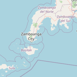
Map view of Basilan Natural Biotic Area

Use this park location map to pinpoint Basilan Natural Biotic Area in Philippines, understand its exact geographic position, and read its mapped placement within the surrounding landscape more clearly.

Pigeon | © OpenStreetMap contributors

Location context for Basilan Natural Biotic Area

Basilan
Park atlas

Compare regional forest reserves and mountain habitats across the southern Philippines

Explore Other Parks Near Basilan Natural Biotic Area and Surrounding Protected Landscapes

Browsing other parks near Basilan Natural Biotic Area reveals connected tropical rainforests and mountain terrain across the Zamboanga Peninsula. Expanding your protected-area comparison clarifies regional conservation footprints and island-wide ecological patterns.
Protected landscapeZamboanga del Sur
About 31 km away#1 closest

North

Great and Little Sta. Cruz Islands Protected Landscape/Seascape Protected Area Map

Coastal ecosystems of the Zamboanga Peninsula

An authoritative look at the Great and Little Sta. Cruz Islands Protected Landscape/Seascape, showcasing the integrated governance of island territory and adjacent marine waters. This site captures the essential coastal geography, intertidal zones, and buffer arrangements that define this significant conservation zone in the southern Philippines.

Area
18.77 km²
Established
2000
Access
Easy access
Scope
Mixed
Protected landscapeZamboanga del Sur
About 161 km away#2 closest

Northeast

Dumanquilas Protected Landscape/Seascape: Mapping Zamboanga Peninsula Coastal Ecosystems

Integrated Marine and Mangrove Reserve Geography

Dumanquilas Protected Landscape/Seascape functions as a comprehensive conservation reserve combining land and sea. This atlas entry details the geography of a bay-centered ecosystem, highlighting the crucial connection between mangrove forest networks and the extended marine buffer within the Celebes Sea.

Area
259.48 km²
Established
1999
Relief
Lowland
Scope
Mixed
National parkMaguindanao del Norte
About 265 km away#3 closest

East

Mado Hot Spring National Park: Protected Geothermal Landscape in Maguindanao del Norte

Explore its therapeutic hot springs and mapped boundaries

Mado Hot Spring National Park, located in Maguindanao del Norte, Philippines, is a protected area defined by its geothermal features and therapeutic hot springs. This national park, established early in the Philippines' conservation history, offers a unique landscape centered around a warm mineral-rich natural pool. Delve into the geographic context and protected area identity of this distinctive site, understanding its role within the region's natural heritage.

Area
0.48 km²
Established
1939
IUCN
II
Scope
Terrestrial
National parkLanao del Sur
About 294 km away#4 closest

Northeast

Sacred Mountain National Park National Park: Detailed Geographic and Protected Landscape Context

Mapped boundaries and regional geography for Sacred Mountain National Park.

Sacred Mountain National Park, a significant national park in Lanao del Sur, offers a distinct protected landscape for atlas-driven discovery. This detailed entry provides insight into its geographic scope and mapped presence, allowing for a deeper understanding of its role within the region. Explore the specific natural terrain and protected area features that define Sacred Mountain National Park, grounded in factual geographic data.

Area
0.94 km²
Established
1965
IUCN
V
Relief
Mountain
A horizontal watercolor painting showing a calm lake in the foreground with lush green hills and distant mountain ridgelines in the background.
Protected areaMaguindanao del Sur
About 307 km away#5 closest

East

Lake Buluan Protected Area: An Atlas Guide to Mindanao Lowland Freshwater Landscapes

Geography and hydrological map of the Maguindanao del Sur wetlands.

Lake Buluan represents a vast, shallow freshwater system known for its extensive marshes and role as a central basin for multiple Mindanao river tributaries. As a protected landscape in Maguindanao del Sur, it offers a distinct look at lowland hydrological patterns, floodplain dynamics, and the cultural history associated with the region's inland water resources.

Area
61.34 km²
Relief
Lowland
Water
Water-dominated
National parkLanao del Sur
About 310 km away#6 closest

Northeast

Lake Butig National Park: National Park Atlas and Geographic Discovery in Lanao del Sur

Discover its mapped boundaries and regional landscape context.

Lake Butig National Park is a protected national park in the Philippines, located within Lanao del Sur. This entry provides specific geographic information and supports atlas exploration by detailing the park's mapped boundaries and its place within the regional landscape. Understand the terrain and protected area context crucial for geographic study and understanding Philippine natural landscapes.

Area
0.68 km²
Established
1965
IUCN
V
Relief
Mountain
National parkLanao del Sur
About 310 km away#7 closest

Northeast

Pantuwaraya Lake National Park: National Park Atlas and Mapped Landscape

Explore the protected area and regional geography of Lanao del Sur.

Understand Pantuwaraya Lake National Park as a defined protected landscape and a significant national park within the Philippines. This entry focuses on its geographic placement in Lanao del Sur, providing context for its mapped boundaries and natural features. Users can explore its representation within a broader atlas of protected lands, gaining insight into its role and landscape identity.

Area
0.2 km²
Established
1965
IUCN
V
Climate
Tropical
National parkLanao del Sur
About 319 km away#8 closest

Northeast

Salikata National Park: Explore Philippines National Park Geography

Mapped protected area boundaries and regional context.

Investigate Salikata National Park, a key protected area designated as a national park within Lanao del Sur, Philippines. This detailed view provides essential context for understanding its mapped boundaries, its place in the regional geography, and its significance as a protected landscape. Discover the unique geographic attributes that define Salikata National Park for atlas-based exploration.

Established
1965
IUCN
V
Relief
Mountain
Climate
Tropical

Common questions about visiting, size, designation, and location context for Basilan Natural Biotic Area

Basilan Natural Biotic Area FAQs for park facts, access, geography, and protected area context

Find quick answers about Basilan Natural Biotic Area, including protected-area facts, park geography, trail and visitor context, and how the park fits into its surrounding country and regional landscape.
MoriAtlas Explorer

Continue Your Protected Areas Search Across the Global Atlas

Deepen your exploration by continuing the structured search for national parks and protected areas worldwide. Utilize the comprehensive filtering capabilities to compare different conservation landscapes and refine your understanding of global park geography. Discover more about the distribution and characteristics of protected natural areas.

Global natural geography