
Mori Atlas logo
Nature reserveBergvennen & Brecklenkampse Veld

Analyzing the mosaic of heathland, weakly buffered fens, and glacial cover sand ridges

Bergvennen & Brecklenkampse Veld Protected Nature Reserve in the Province of Overijssel

Bergvennen & Brecklenkampse Veld represents a critical nature reserve situated on the higher sandy soils of the Twente region in the eastern Netherlands. This protected area features a complex mosaic of wet and dry heathlands, species-rich grasslands, and oak-birch woodlands shaped by historic glacial cover sand ridges. Our atlas-driven documentation provides a deep look at the ecological gradients and hydrological patterns that sustain these rare habitats across the Dutch-German border.

Natura 2000heathlandfenweakly buffered fencover sand ridgesjuniper scrub
A flat-style digital illustration depicting a single bare tree centered in a meadow with a park bench at its base, framed by mountains in the distance and a winding path in the foreground.

Bergvennen & Brecklenkampse Veld

Nature reserve

Park overview

Structured park overview, official facts, and landscape profile for Bergvennen & Brecklenkampse Veld

Bergvennen & Brecklenkampse Veld park facts, protected area profile, and essential visitor context

Review the core facts for Bergvennen & Brecklenkampse Veld, including designation, size, terrain, visitor scale, habitats, and operating context in one park-focused overview.

About Bergvennen & Brecklenkampse Veld

Bergvennen & Brecklenkampse Veld is a small but ecologically dense Natura 2000 protected area located in the Twente region of Overijssel, in the eastern part of the Netherlands. Situated in the municipality of Dinkelland and near the village of Breklenkamp, the area sits on the higher sandy soils that characterise much of this part of the country, and it forms a compact but varied landscape of heath, fen, juniper scrub, and woodland.

At its heart lies the Bergvennen sub-area, a heath landscape on ancient cover sand ridges in which several large weakly buffered fens are embedded. These fens occupy shallow depressions in the sand landscape and depend on very specific chemical and hydrological conditions to maintain their characteristic vegetation. Because natural buffering in such settings is limited, groundwater management is actively used to keep the water chemistry suitable for the specialist species that live there, including pumping groundwater during the winter months to reinforce the buffering capacity.

Directly to the north of the Bergvennen lies the Brecklenkampse Veld, a more accidented landscape defined by cover sand ridges and a rich set of ecological gradients. Heath transitions here into nutrient-poor grasslands and low-lying areas where littoral vegetation takes hold. Small patches of moist oak-birch woodland add further structural variety. On the flanks of the ridges, baserich seepage feeds areas of species-rich acidic grassland and blue grassland, creating pockets of high botanical value within an otherwise acid-dominated landscape.

The protected area sits right on the Dutch-German border, where it connects ecologically with a forested area on the German side. This transboundary position increases its conservation value, as it forms part of a wider network of heath, woodland, and fen habitats that cross the frontier. Within the Dutch Natura 2000 system, the site carries the number 46 and was officially designated on 4 May 2013 under the Habitats Directive, underscoring its recognised significance at the European level despite its compact size.

Quick facts and research context for Bergvennen & Brecklenkampse Veld

Bergvennen & Brecklenkampse Veld is site number 46 in the Dutch Natura 2000 network and falls under the European Habitats Directive. The area covers roughly 133 hectares and is classified within the higher sandy soils landscape type of the Netherlands. It is administered by the municipality of Dinkelland in the province of Overijssel.

The protected landscape consists of three connected sub-areas, each with its own character, including the Bergvennen heath with its large weakly buffered fens, the Brecklenkampse Veld to the north with its gradient-rich cover sand ridges, and the baserich seepage zones on the flanks of the ridges where species-rich acidic grasslands develop. The site lies directly on the Dutch-German border and continues ecologically into an adjacent forested area across the frontier.

Protection and recognition

Terrestrial protected area framework and international designation records

Bergvennen & Brecklenkampse Veld Protection Status and Natura 2000 Recognition

Bergvennen & Brecklenkampse Veld holds documented terrestrial protection status supported by official Natura 2000 recognition records. Regional conservation data outlines the established management scope and cross-border environmental designations.

International recognition

Protection details

Protection scope
Terrestrial
Transboundary protection
Yes
Park context

Deeper park guide and search-rich context for Bergvennen & Brecklenkampse Veld

Bergvennen & Brecklenkampse Veld history, landscape, wildlife, and travel context

Explore Bergvennen & Brecklenkampse Veld through its history, landscape character, ecosystems, wildlife, conservation priorities, cultural context, and seasonal travel timing in a structured park guide built for atlas discovery and search intent.

Why Bergvennen & Brecklenkampse Veld stands out

The site is best known for its weakly buffered fens set within heath-covered cover sand ridges, a habitat combination that has become exceptionally rare in northwestern Europe. These fens, some of the larger examples of their type in the region, require careful hydrological management, including active groundwater buffering during winter to maintain the chemical conditions that the specialist plant and animal communities depend on. Equally distinctive is the gradient-rich landscape of the Brecklenkampse Veld, where heath transitions into nutrient-poor grasslands and low-lying fen areas. The flanks of the ridges carry juniper scrub, bog-myrtle thickets, and baserich seepage zones that support small-sedge communities and other rare vegetation types, all of which together make this compact area a flagship for habitat conservation on the Dutch sandy soils.
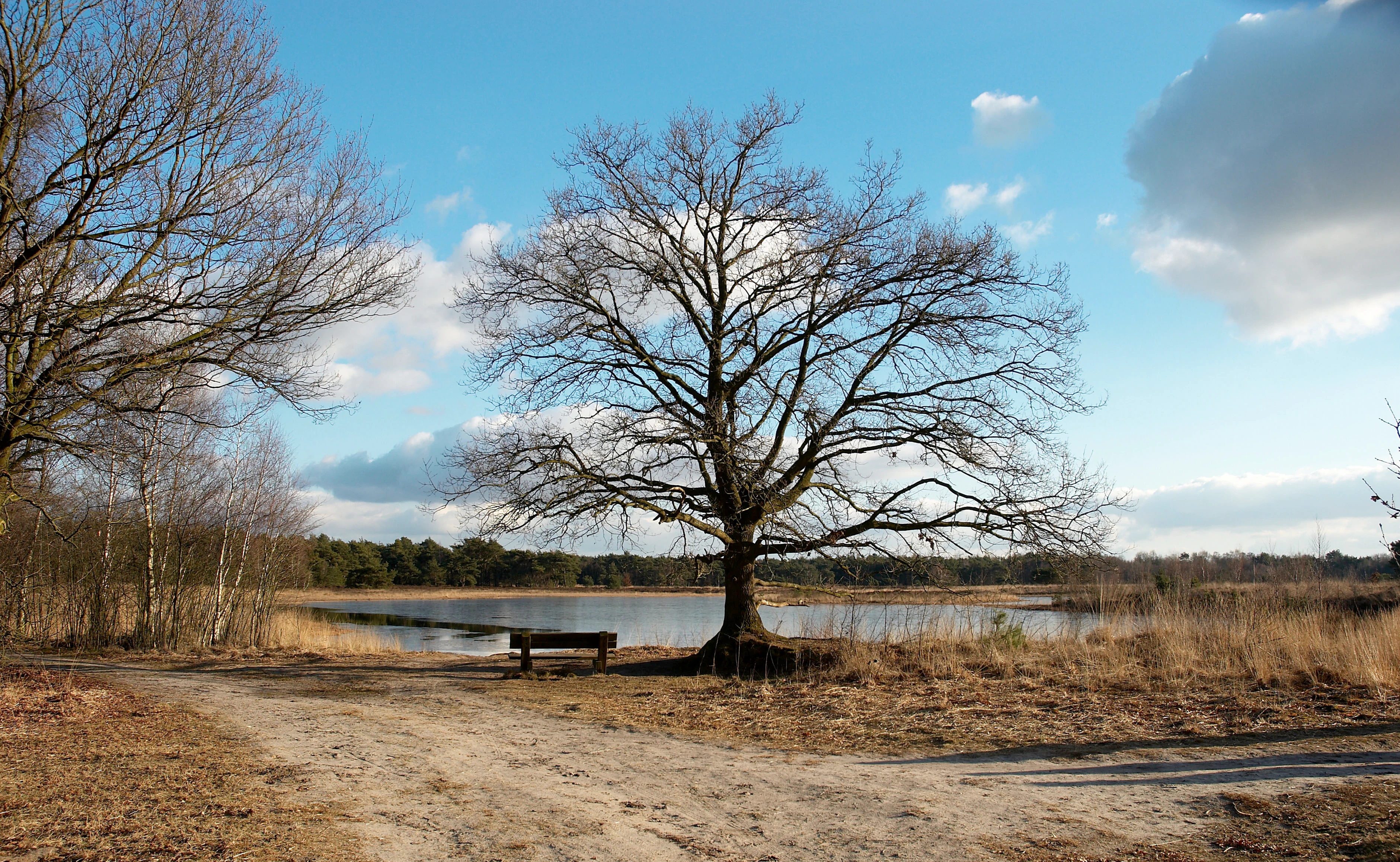
A wide shot of a bare deciduous tree centered in a landscape of sandy ground and a small lake, with a wooden bench underneath the tree.
A solitary tree stands by a quiet fen in the Bergvennen nature reserve.

Bergvennen & Brecklenkampse Veld history and protected-area timeline

The recent history of Bergvennen & Brecklenkampse Veld is closely tied to the Natura 2000 programme. The area was formally designated as a Dutch Natura 2000 site on 4 May 2013, becoming site number 46 in the national list. Its designation falls under the European Habitats Directive, reflecting the area's importance for specific habitat types and species listed under that framework.

Prior to formal protection under Natura 2000, the area's heath, fen, and grassland systems were shaped by traditional land use and by ongoing habitat management. Restoration measures have been carried out successfully in parts of the Brecklenkampse Veld, helping to re-establish the ecological gradients and vegetation communities that define its character. Active interventions, including the artificial buffering of the weakly buffered fens through winter groundwater pumping, represent a modern management approach that continues to refine how the area's hydrology is maintained.

Bergvennen & Brecklenkampse Veld landscape and geographic character

The landscape of Bergvennen & Brecklenkampse Veld is defined by cover sand ridges and the depressions between them, an inheritance of the Pleistocene glaciation that shaped much of the eastern Netherlands. The result is a gently undulating surface of sandy ridges interspersed with low-lying zones where water collects and where fens form. The Bergvennen itself sits on a series of these ridges, while the Brecklenkampse Veld immediately to the north offers a more accidented terrain where the gradients between dry ridge tops and wet lower ground are especially pronounced.

Along the flanks of the ridges, baserich seepage emerges where minerally richer groundwater meets the sandy slopes. These seepage zones contrast with the generally acidic character of the surrounding heath, producing localised pockets of nutrient-poor but baserich grassland that add subtle colour and botanical richness to the landscape. Narrow belts of vegetation along the fens provide additional transitions between open water, wet heath, and dry heath, reinforcing the sense of a finely graded mosaic rather than a uniform expanse.

Bergvennen & Brecklenkampse Veld ecosystems, habitats, and plant life

Ecologically, Bergvennen & Brecklenkampse Veld is best understood as a mosaic of rare habitats on higher sandy soils. The area encompasses weakly buffered fens, wet and dry heathlands, species-rich heathy grasslands, juniper scrub, and patches of moist oak-birch woodland. This concentration of habitat types within a small area gives the site an unusually high ecological density for its size.

The weakly buffered fens are among the defining features of the area. These are shallow, relatively nutrient-poor water bodies whose chemistry is easily disturbed, and they require careful management to maintain the buffering capacity that keeps them suitable for their characteristic plant communities. Around them, narrow belts of bog-myrtle thicket and juniper scrub line the transitions between open water and surrounding heath.

The Brecklenkampse Veld adds further ecological depth through its gradient-rich ridges. Here, heath on the upper slopes gives way to nutrient-poor grasslands and low-lying areas supporting littoral vegetation. On the flanks, baserich seepage creates conditions for small-sedge communities and other species associated with acidic, nutrient-poor grasslands that nonetheless receive a steady supply of base-enriched groundwater. Moist oak-birch woodland adds a wooded component that supports different species and provides structural diversity across the site.

Bergvennen & Brecklenkampse Veld wildlife and species highlights

Although the source material emphasises habitat types rather than specific species lists, the mosaic of heath, fen, woodland, and seepage zones in Bergvennen & Brecklenkampse Veld supports a rich wildlife community tied closely to these specific conditions. Weakly buffered fens and surrounding wet heath provide breeding and feeding habitat for invertebrates and birds associated with open, acidic, water-rich landscapes, while dry heath and juniper scrub support species adapted to warmer, drier conditions.

The moist oak-birch woodland patches add a forest-edge dimension, offering shelter and food resources for woodland and edge specialists. The transboundary connection with forest on the German side of the border further strengthens the area's role as part of a wider ecological network, allowing wildlife to move between habitats across the frontier.

Bergvennen & Brecklenkampse Veld conservation status and protection priorities

Bergvennen & Brecklenkampse Veld is recognised under the European Habitats Directive as site NL2003007, placing it within the Natura 2000 network that protects threatened habitats and species across the European Union. The designation acknowledges that several of the habitats present here are rare and in decline across their wider range, including weakly buffered fens, dry and wet heath, juniper scrub, and baserich seepage grasslands.

Conservation management in the area is hands-on. The hydrology of the weakly buffered fens is actively maintained through groundwater pumping during winter, an intervention needed to reinforce the natural buffering that has become too weak to sustain the specialist communities on its own. In the Brecklenkampse Veld, habitat restoration has been carried out successfully, re-establishing ecological conditions that allow the characteristic gradient between heath, nutrient-poor grassland, and seepage to recover. The transboundary position of the site also gives it conservation value beyond its own boundaries, as it functions as a Dutch anchor in a wider landscape of protected habitats that continues into Germany.

Bergvennen & Brecklenkampse Veld cultural meaning and human context

The cultural context of Bergvennen & Brecklenkampse Veld is shaped by the long history of land use on the higher sandy soils of Twente. The presence of heath, nutrient-poor grasslands, juniper scrub, and small woodland patches reflects centuries of interaction between people and this landscape, with traditional management practices having helped to maintain the open character of the moors and the boundaries between different vegetation types.

The site's position along the Dutch-German border adds a transboundary dimension to its cultural setting, as much of the surrounding countryside shares land-use traditions and ecological character between the two countries. While the area is now formally managed for nature conservation, its identity is still rooted in the regional landscape of eastern Overijssel, where small villages such as Breklenkamp lie embedded in a mosaic of farmland, woodland, and heath.

Top sights and standout views in Bergvennen & Brecklenkampse Veld

Bergvennen & Brecklenkampse Veld stands out for the unusual concentration of rare habitats packed into a small area: weakly buffered fens, dry and wet heath, juniper scrub, heathy grasslands, bog-myrtle thickets, and moist oak-birch woodland all occur together. Cover sand ridges with seepage on their flanks create the gradient-rich conditions that make the Brecklenkampse Veld particularly distinctive.

The site is also notable for its transboundary position, linking directly with a protected woodland area on the German side of the border and forming part of a wider ecological network across the frontier. Its formal designation as Natura 2000 site number 46 in 2013 under the Habitats Directive underlines the European-level importance of a relatively modest Dutch nature reserve.

Best time to visit Bergvennen & Brecklenkampse Veld

Although the source material does not provide detailed visitor logistics, the character of Bergvennen & Brecklenkampse Veld shifts across the seasons in ways typical of Dutch heath and fen landscapes. Late spring and summer are generally the most rewarding periods for seeing the area at its most botanically expressive, when heath, juniper scrub, and seepage grasslands display their varied greens and the fens are at their most active ecologically.

Autumn brings shifts in colour across the heath and woodland, while winter is a quieter time when the open landscape and frost make the underlying landforms more visible and the hydrological management of the fens becomes most visible in the broader landscape context.


Monthly climate preview

Long-term temperature ranges and monthly precipitation recorded at representative coordinates

Bergvennen & Brecklenkampse Veld Climate Normals and Annual Weather Patterns

Historical data compiled from NASA Power reveals measured monthly temperature swings and precipitation averages across the park coordinate point. Examining the complete twelve-month sequence provides deeper context for long-term climatic rhythms throughout the protected landscape.
Annual mean10 °C
2 °C18 °C
Jan
Feb
Mar
Apr
May13°
Jun16°
Jul18°
Aug18°
Sep14°
Oct10°
Nov
Dec
Warmest month
July

18.1 °C

Coolest month
January

1.7 °C

Wettest month
December

2.5 mm/day

Driest month
April

1.4 mm/day

Park location guide

Geography guide, regional context, and park location map for Bergvennen & Brecklenkampse Veld

Bergvennen & Brecklenkampse Veld park geography, regions, and map view in Netherlands

Understand where Bergvennen & Brecklenkampse Veld sits in Netherlands through a broader geographic reading of the surrounding landscape, nearby location context, and its mapped position within the national park landscape.

How Bergvennen & Brecklenkampse Veld fits into Netherlands

The Netherlands is a low-lying coastal country in Northwestern Europe, famous for its extensive dike and canal systems that reclaim land from the sea. It consists of twelve provinces and is known for tulips, windmills, and cycling culture. The country is a founding member of the European Union with Amsterdam as its capital and The Hague as the seat of government.

Wider geography shaping Bergvennen & Brecklenkampse Veld in Netherlands

The Netherlands is located in Northwestern Europe along the North Sea coastline to the north and west. It borders Germany to the east and Belgium to the south. The country is notably flat, with a significant portion of its territory lying below sea level, protected by dikes and dune systems. It consists of twelve provinces and also includes overseas municipalities in the Caribbean.

Map view of Bergvennen & Brecklenkampse Veld

Use this park location map to pinpoint Bergvennen & Brecklenkampse Veld in Netherlands, understand its exact geographic position, and read its mapped placement within the surrounding landscape more clearly.

Pigeon | © OpenStreetMap contributors

Location context for Bergvennen & Brecklenkampse Veld

Overijssel
Recorded earthquake history

Explore Historical Earthquake Records for Bergvennen & Brecklenkampse Veld

Review the recorded seismic history associated with the geography of Bergvennen & Brecklenkampse Veld. MoriAtlas provides this factual catalogue of earthquake data for researchers and curious explorers interested in regional seismic patterns near this Dutch nature reserve.

Bergvennen & Brecklenkampse Veld Earthquake History

Catalogued events

7 events

Strongest magnitude

Magnitude 4.7

Most recent event

Jul 18, 2008

This history includes earthquakes recorded inside the park or within 50 km of its borders

Visual reference of rare fens, cover sand ridges, and heathland habitats

Bergvennen & Brecklenkampse Veld Photos and Protected Landscape Scenery

Photographic collections reveal the complex terrain, weakly buffered fens, and undulating cover sand ridges defining Bergvennen & Brecklenkampse Veld. Visual documentation helps researchers and visitors analyze protected habitat transitions and regional conservation character across the landscape.

A wide shot of a bare deciduous tree centered in a landscape of sandy ground and a small lake, with a wooden bench underneath the tree.

Park atlas

Compare nearby regional parks and connected transboundary nature reserves

Exploring Other Protected Areas Near Bergvennen & Brecklenkampse Veld

Continue investigating protected landscapes and regional habitats situated close to Bergvennen & Brecklenkampse Veld. Comparing adjacent terrain provides a clearer view of shared sandy soils, fens, and cross-border conservation networks.
Protected areaOverijssel
5.6 km away#1 closest

West

Springendal & Dal van de Mosbeek Protected Area: Mapped Geography and Terrain Overview

Glacial push-moraine landscapes in the Overijssel province

The Springendal & Dal van de Mosbeek protected area stands out for its concentrated geological diversity, where boulder-clay layers trigger consistent groundwater seepage. This natural process maintains rare ash-elm spring forests and calcareous mires within a twelve square kilometer expanse. The area preserves a classic Twente cultural pattern of small meadows and hedgerows, creating a protected sanctuary for specialized invertebrates and woodland wildlife.

Area
12.25 km²
Established
2013
Relief
Upland
Scope
Terrestrial
Nature reserveNiedersachsen
8.2 km away#2 closest

Southeast

Syen-Venn Nature Reserve: Geographic Overview of Mired Landscapes in Lower Saxony

A study of raised bog regeneration, peatlands, and wetland bird habitats

Syen-Venn is a prominent nature reserve in Niedersachsen, characterized by its long-standing history of mire conservation and active bog surface regeneration. The landscape features diverse structural elements including cottongrass-covered hummocks, nutrient-poor standing waters, and moor birch woodlands that provide essential habitat within the broader regional geography of northern Germany.

Area
1.96 km²
Established
1936
Nature reserveGrafschaft Bentheim
About 10 km away#3 closest

Southeast

Weiher am Syen-Venn Nature Reserve: Protected Landscapes and Geography in Grafschaft Bentheim

Exploring nutrient-poor ponds and meadow buffer zones

Weiher am Syen-Venn stands as a significant nature reserve in Grafschaft Bentheim, defined by its flat lowland terrain and aquatic-focused ecological zones. The protected area encompasses nearly 30 hectares of meadows and ponds, providing vital refuge for moor frogs and migratory bird species within an agricultural landscape framework.

Area
0.28 km²
Established
2016
Relief
Lowland
Climate
Temperate
A soft watercolor painting of a green meadow landscape with a small pond, cattails, and gentle forested hills in the background.
Nature reserveOverijssel
About 13 km away#4 closest

South

Landgoederen Oldenzaal: Mapping the Protected Estate Forests of Overijssel

Nature reserve geography and habitat connectivity in Twente

Landgoederen Oldenzaal comprises a series of historical estates at the foot of the Oldenzaal ice-pushed ridge. The landscape is characterized by mature woodland complexes, spring-fed brooks, and a traditional field pattern that persists today. As a protected Natura 2000 site, it demonstrates successful habitat reconnection through specialized infrastructure within the wider Twente region.

Area
5.78 km²
Established
2013
Relief
Upland
Climate
Temperate
Nature reserveLandkreis Grafschaft Bentheim
About 15 km away#5 closest

Southeast

FFH-Gebiet Bentheimer Wald: A Deep Dive into German Protected Woodland and Forest Terrain

Historic wood pasture in Landkreis Grafschaft Bentheim

Explore the geographical structure and protected status of FFH-Gebiet Bentheimer Wald. This woodland region is renowned for its Hutewald heritage, riparian streams, and ancient growth that supports rare lichen and bryophyte species across its expansive lowland forest canopy.

Area
7.8 km²
Relief
Lowland
Climate
Temperate
Access
Access unknown
Nature reserveOverijssel
About 20 km away#6 closest

Southwest

Landgoed Lonnekermeer Nature Reserve: Geographic Landscape and Protected Area Mapping

Twente region, Overijssel province, Netherlands

Landgoed Lonnekermeer is a 98 hectare nature reserve in Overijssel characterized by a designed early twentieth century landscape, lakes originating from historic sand quarries, and expansive wet heath. Explore the protected boundaries of this estate as it serves as a living model for habitat restoration, showcasing the successful recovery of local fens, brooks, and biodiversity-rich hay meadows within the eastern Netherlands.

Area
1.05 km²
Established
1902
Relief
Lowland
Climate
Temperate
Nature reserveOverijssel
21 km away#7 closest

West

Engbertsdijksvenen Nature Reserve: Mapping Dutch Raised Bog and Peatland Landscapes

Protected high moor geography in the Overijssel region

Engbertsdijksvenen is a significant nature reserve in the eastern Netherlands, renowned for its extensive living raised bog and diverse peatland habitats. The site showcases a rare mosaic of open water, heathland, and bog forest, serving as a landmark for ecological restoration and wetland geography in the province of Overijssel.

Area
10 km²
Relief
Upland
Climate
Temperate
Access
Easy access
Nature reserveOverijssel
31 km away#8 closest

South

Witte Veen Nature Reserve: Mapped Protected Landscapes and Bog Terrain in Overijssel, NL

Regional peatland geography and cross-border conservation status

Witte Veen is a protected nature reserve in eastern Overijssel, known for its distinct raised bog habitat and active restoration efforts. This site forms an essential link in the Dutch-German border chain, offering a unique look at fragmented wetland terrain, bog pools, and heathland ecosystems managed for ecological recovery.

Area
2.9 km²
Established
2013
Relief
Lowland
Climate
Temperate

Common questions about visiting, size, designation, and location context for Bergvennen & Brecklenkampse Veld

Bergvennen & Brecklenkampse Veld FAQs for park facts, access, geography, and protected area context

Find quick answers about Bergvennen & Brecklenkampse Veld, including protected-area facts, park geography, trail and visitor context, and how the park fits into its surrounding country and regional landscape.
MoriAtlas Explorer

Continue Your Protected Areas Search Across the Global Atlas

Deepen your exploration by continuing the structured search for national parks and protected areas worldwide. Utilize the comprehensive filtering capabilities to compare different conservation landscapes and refine your understanding of global park geography. Discover more about the distribution and characteristics of protected natural areas.

Global natural geography