Mori Atlas logo
Nature reserveEngbertsdijksvenen

Tracing the mapped boundaries and unique hydrological terrain of a vital raised bog landscape

Engbertsdijksvenen Nature Reserve in Overijssel: A Premier Dutch Peatland and Bog Conservation Area

Engbertsdijksvenen stands as a critical nature reserve in the Overijssel province, representing one of the largest concentrations of living raised bog on the Dutch mainland. This protected landscape features a complex mosaic of peat pools, dry heath, and bog forests created by both historical peat extraction and modern hydrological restoration. The area provides a unique window into the fragile ecosystem of high moor environments near the German border, offering defined paths to observe the interplay of water and vegetation across the varied sandy ridges and wetland basins.

raised bogpeatlandhigh moorwetlandsdry heathwet heath

Engbertsdijksvenen

Nature reserve

Park overview

Structured park overview, official facts, and landscape profile for Engbertsdijksvenen

Engbertsdijksvenen park facts, protected area profile, and essential visitor context

Review the core facts for Engbertsdijksvenen, including designation, size, terrain, visitor scale, habitats, and operating context in one park-focused overview.

About Engbertsdijksvenen

Engbertsdijksvenen is one of the most important peatland reserves in the Netherlands. Located in Twenterand, Overijssel, near the villages of Kloosterhaar and Westerhaar-Vriezenveensewijk, it sits in the eastern part of the country just a short distance from the German border. The reserve covers roughly 1000 hectares and is managed by the Dutch Forestry Commission, Staatsbosbeheer, as a state nature monument.

The defining character of Engbertsdijksvenen lies in its peatland landscapes. Although the broader Netherlands once lay under extensive bog and moor, very little active raised bog survives today. Engbertsdijksvenen holds an exceptionally large fraction of the country's remaining 'levend hoogveen', giving it a regional and national importance that far exceeds its modest size. The area is part of the European Natura 2000 network, which links protected natural sites across the continent and recognizes the reserve's contribution to safeguarding threatened bog habitats.

Ecologically, the area is a mosaic. Within a compact landscape one finds open peat pools, wet heath, dry heath on sandy ridges, birch woodland, and small bog forests. These different habitats lie close together and create the layered scenery typical of the Twente peatlands. Restoration efforts over the past decades have focused on hydrology, with dams and embankments built to retain water in the central bog areas so that new peat can begin to form. The surviving 'resting' raised bog, where peat growth has paused but the structure remains intact, is also considered ecologically and geologically valuable.

The reserve is also significant for birdlife. BirdLife International has recognized it as an Important Bird Area, particularly for populations of cranes and bean geese that rely on the bog and its surroundings. Butterflies, dragonflies and characteristic bog plants further underline the site's biodiversity interest. For visitors, the reserve offers a calming landscape of quiet paths, a long-distance heath walk and bird observation points, while nearby cultural features such as the Veenmuseum in Westerhaar-Vriezenveensewijk connect the natural area to the long human history of working the peat.

Quick facts and research context for Engbertsdijksvenen

Engbertsdijksvenen is a state nature monument of roughly 1000 hectares located in the municipality of Twenterand, Overijssel, near the German border. It is managed by Staatsbosbeheer and protected within the European Natura 2000 network. The area holds a nationally exceptional share of the Netherlands' remaining living raised bog, alongside dry heath, peat pools and birch woodland. The landscape was shaped by centuries of peat extraction, including the industrial-scale Veenkoloniën operations of 1850 to 1950, and the canal and ditch pattern still visible across the site.

Protection and recognition

Documented terrestrial protection scope, Natura 2000 listings, and Ramsar wetland recognition

Engbertsdijksvenen Protection Status and International Recognition Data

Engbertsdijksvenen maintains documented terrestrial protection status supported by official Natura 2000 frameworks and Ramsar wetland designations. Structured recognition records establish the baseline conservation framework for analyzing regional habitat management.
Park context

Deeper park guide and search-rich context for Engbertsdijksvenen

Engbertsdijksvenen history, landscape, wildlife, and travel context

Explore Engbertsdijksvenen through its history, landscape character, ecosystems, wildlife, conservation priorities, cultural context, and seasonal travel timing in a structured park guide built for atlas discovery and search intent.

Why Engbertsdijksvenen stands out

Engbertsdijksvenen is best known for containing the largest concentration of living raised bog, or 'levend hoogveen', on the Dutch mainland. It is also recognized for its combination of bog, heath, peat lakes and small woodlands, all packed into a relatively compact area near the German border. The site's peatland character is its defining quality. Restoration work in the late twentieth and early twenty-first centuries, including dams and small embankments to stabilize the water table, has been aimed at reviving active bog growth. This combination of ecological value, conservation effort and a varied peatland landscape has made Engbertsdijksvenen one of the key nodes in the Dutch Natura 2000 network.
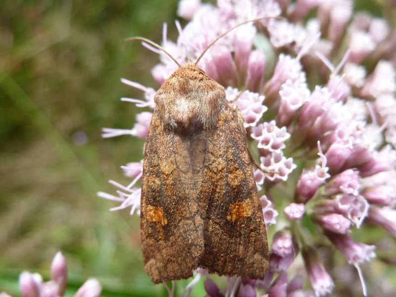
A close-up view of a brown moth with mottled wings resting on a cluster of small light-purple flowers.
A moth resting on a flowering plant in Engbertsdijksvenen.

Engbertsdijksvenen history and protected-area timeline

Human influence on Engbertsdijksvenen was modest for centuries. Until the nineteenth century, the area saw mainly sheep grazing, small-scale buckwheat burning as a cultivation technique, and limited peat cutting for local use. The monks of the Sibculo monastery had begun digging peat here as early as the fifteenth century, but their work left the broader landscape largely intact.

Industrial-scale extraction transformed the area between 1850 and 1950 during the so-called colonial peat cutting period. Canals and drainage ditches were dug between 1890 and 1907 to open up the bog for systematic harvesting from Vriezenveenschewijk, the settlement that would later become Westerhaar-Vriezenveensewijk. The construction of the Veenkanaal was especially decisive in reshaping the surrounding landscape. Peat removal left behind large open pools and the distinctive inland water bodies that are still a hallmark of the site today.

In the late twentieth and early twenty-first centuries the focus shifted from extraction to restoration. Dams and embankments were installed to regulate water levels and revive conditions for living raised bog. A narrow-gauge railway once used for peat transport was used for an excursion train between 1999 and 2006, but the final rails were removed in 2008 when a boulder clay dam was constructed to counter dehydration of the bog, highlighting how conservation priorities came to dominate the modern management of the site.

Engbertsdijksvenen landscape and geographic character

Engbertsdijksvenen presents a layered peatland landscape shaped by both natural development and centuries of peat exploitation. Within a single visit one can move between open peat pools, low bog forest, dry heath on sandy ridges, and gently undulating mixed woodland. The sandier higher areas, locally known as 'haren', carry the highest vegetation and often support forest, a name echoed in surrounding villages such as Kloosterhaar, Westerhaar-Vriezenveensewijk and Bruinehaar.

The relief of the area is more varied than its flat surroundings might suggest. Higher ground rises above flatter bog compartments, and local altitude differences give the area a subtly rolling character. Large open water bodies mark where peat was once removed, and along with smaller 'vennen' (pools) they contribute to the open, reflective quality of much of the reserve. Surrounding agricultural land shows the typical long, narrow parceling of the colonial peatlands, contrasting with the more natural mosaic of the protected area itself.

Engbertsdijksvenen ecosystems, habitats, and plant life

Engbertsdijksvenen is a textbook example of a Dutch high bog mosaic. The reserve centers on raised bog habitat, surrounded by wet and dry heath, bog forest dominated by soft birch, and small areas of poorer mineral soil vegetation. Sphagnum mosses are a key building block of the bog communities and indicate where peat can still actively accumulate.

Plant life in the area includes numerous specialized peatland species. Among the typical bog plants found here are common cottongrass, cranberry, sundews and lavender heather. In the birch-dominated bog forest, the rare snake root is known to occur, and other parts of the reserve host several orchid species. The combination of bog plants, heath plants and woodland species on sandy ground produces a rich and unusual botanical mix in a relatively confined space.

Habitats range from very wet pools and quaking bog surfaces to drier sandy ridges with heather and small woodland patches. Restoration work has focused on maintaining high water levels in the core areas, which is essential for letting new peat begin forming again. The 'resting' peat areas, where active growth has stopped but the structure remains, are also valued as ecologically and geologically important reservoir habitat.

Engbertsdijksvenen wildlife and species highlights

The reserve is rich in birdlife and is recognized as an Important Bird Area by BirdLife International because of its importance for crane and bean goose populations. Other regularly occurring birds include bluethroat, stonechat and black-necked grebe, all characteristic of bog and wet heath habitats. Such bird communities reflect the combination of open water, reedbeds, scrub and small woodland that the reserve provides.

Reptiles, amphibians and insects complete the picture. Adders, smooth snakes, viviparous lizards and common frogs are among the species reported in and around the bog. Butterflies associated with the heath landscape, such as the grayling, are typical for the area, and in summer dragonflies including four-spotted chasers and emperor dragonflies hunt above the open water. A characteristic bog moth, the large heath moth, is also associated with the site, further underlining its insect biodiversity.

The range of wildlife reflects the variety of habitats packed into the reserve. Drier patches of heath, wet bog, bog forest and open water each support different species groups, and the relatively undisturbed core of the area offers breeding and feeding habitat for sensitive specialists that have largely disappeared from the broader Dutch countryside.

Engbertsdijksvenen conservation status and protection priorities

Engbertsdijksvenen carries national significance for peatland conservation. It holds an exceptional share of the few hectares of living raised bog that survive in the Netherlands, making every square meter of its core hydrology a priority for safeguarding. The site is protected as a state nature monument and is part of the European Natura 2000 network, giving it formal recognition in both national and continental frameworks.

Restoration has been the main conservation story of recent decades. Late twentieth and early twenty-first century hydrological works, including dams, embankments and boulder clay barriers, were introduced to counter dehydration and to re-establish conditions under which new peat can begin growing. These interventions reflect a broader Dutch and European effort to restore raised bog, an internationally rare habitat that stores carbon, regulates water and supports specialized species.

BirdLife International's designation of the reserve as an Important Bird Area further underlines its conservation value for migratory and breeding bird populations, particularly cranes and bean geese. Together, the formal Natura 2000 status, the IBA recognition and the active hydrological management make Engbertsdijksvenen one of the more intensively managed, yet ecologically valuable, peatland sites in the Netherlands.

Engbertsdijksvenen cultural meaning and human context

The name 'Engbertsdijksvenen' and surrounding villages such as Kloosterhaar and Westerhaar-Vriezenveensewijk reflect deep layers of regional history. The 'haar' element, meaning a sandy rise, appears in multiple local place names and reveals how the dry sandy ridges stood out as natural landmarks in the otherwise wet peatland landscape. The first documented large-scale peat cutting in the area was carried out by monks from the Sibculo monastery during the fifteenth century.

The colonial peat era of 1850 to 1950 left an even stronger mark. Canals such as the Veenkanaal, long strip-like field patterns, planned settlements like Westerhaar-Vriezenveensewijk and the narrow-gauge railways used for peat transport are all legacies of this period. The nearby Veenmuseum in Westerhaar-Vriezenveensewijk preserves turfcarts, small locomotives and other tools that explain how life and work were organized around the peat. Together, these features show that Engbertsdijksvenen is not only a natural heritage site but also a cultural landscape shaped by centuries of human interaction with the bog.

Top sights and standout views in Engbertsdijksvenen

Engbertsdijksvenen's highlights center on its peatland character. The reserve concentrates a nationally significant proportion of the Netherlands' living raised bog, complemented by a striking mosaic of peat pools, dry and wet heath, birch bog forest and small woodland patches. BirdLife International has highlighted it as an Important Bird Area for species such as crane and bean goose, while botanical specialties like sundews, cottongrass and the rare snake root reflect the integrity of its peatland habitats.

A further highlight is the modern restoration story. Hydrological works, including boulder clay dams and embankments, have been designed to revive peat growth after decades of drainage, a rare example of active ecological rewetting in the Dutch countryside. Combined with a marked heath walking route and bird observation points, this gives the reserve both scientific and recreational appeal within a single landscape.

Best time to visit Engbertsdijksvenen

Engbertsdijksvenen is most rewarding in the warmer months, when peatland vegetation is active and the open pools and heath are at their most vivid. Late spring and summer bring flowering heath, the flight of dragonflies above the water and the strongest chance of observing bog butterflies, reptiles and breeding birds. Migratory species such as cranes and bean geese lend a particular seasonality to the area, and quieter periods outside the busiest weekends often suit bird observation best. Cooler months still offer atmospheric walks across the heath and bog, but experiences tend to emphasize the stark, open character of the landscape rather than species encounters.

Monthly climate preview

Measured annual temperature variation and representative precipitation rhythm across twelve months

Engbertsdijksvenen Climate Normals and Long-Term Weather by Month

Long-term NASA Power climatology records outline the representative temperature swings and monthly precipitation rates recorded at coordinates within Engbertsdijksvenen. Reviewing the complete twelve-month profile provides deeper insight into the measured thermal and moisture patterns governing the protected landscape.
Annual mean10 °C
2 °C18 °C
Jan
Feb
Mar
Apr
May13°
Jun16°
Jul18°
Aug18°
Sep14°
Oct10°
Nov
Dec
Warmest month
July

18.1 °C

Coolest month
January

1.7 °C

Wettest month
December

2.5 mm/day

Driest month
April

1.4 mm/day

Park location guide

Geography guide, regional context, and park location map for Engbertsdijksvenen

Engbertsdijksvenen park geography, regions, and map view in Netherlands

Understand where Engbertsdijksvenen sits in Netherlands through a broader geographic reading of the surrounding landscape, nearby location context, and its mapped position within the national park landscape.

How Engbertsdijksvenen fits into Netherlands

The Netherlands is a low-lying coastal country in Northwestern Europe, famous for its extensive dike and canal systems that reclaim land from the sea. It consists of twelve provinces and is known for tulips, windmills, and cycling culture. The country is a founding member of the European Union with Amsterdam as its capital and The Hague as the seat of government.

Wider geography shaping Engbertsdijksvenen in Netherlands

The Netherlands is located in Northwestern Europe along the North Sea coastline to the north and west. It borders Germany to the east and Belgium to the south. The country is notably flat, with a significant portion of its territory lying below sea level, protected by dikes and dune systems. It consists of twelve provinces and also includes overseas municipalities in the Caribbean.

Map view of Engbertsdijksvenen

Use this park location map to pinpoint Engbertsdijksvenen in Netherlands, understand its exact geographic position, and read its mapped placement within the surrounding landscape more clearly.

Pigeon | © OpenStreetMap contributors

Location context for Engbertsdijksvenen

Overijssel
Recorded earthquake history

Explore the Historical Earthquake Catalogue for Engbertsdijksvenen

Review documented seismic activity near Engbertsdijksvenen through this structured historical collection. MoriAtlas provides transparent access to recorded earthquake data including event timing, magnitude, and relative distance to this protected landscape in Overijssel.

Engbertsdijksvenen Earthquake History

Catalogued events

1 event

Strongest magnitude

Magnitude 3

Most recent event

Jun 21, 2004

This history includes earthquakes recorded inside the park or within 50 km of its borders

Visualizing the raised bog habitats and protected terrain of Overijssel

Engbertsdijksvenen Photos and Landscape Scenery

Visual documentation captures the rare raised bog habitats, open peat pools, and dry heath ridges that define Engbertsdijksvenen. Studying these protected area photographs reveals the diverse terrain, wetland ecology, and conservation character of the Dutch reserve.

A close-up view of a brown moth with mottled wings resting on a cluster of small light-purple flowers.

Park atlas

Compare surrounding nature reserves and connected wetland landscapes across Overijssel.

Parks Near Engbertsdijksvenen, Exploring Regional Protected Areas and Mapped Terrain

Browse other protected areas near Engbertsdijksvenen to examine similar peatland ecosystems, heath terrain, and regional conservation networks. Comparing adjacent nature reserves provides valuable geographical context for understanding regional wetland habitats and protected landscapes.
Protected areaOverijssel
8.4 km away#1 closest

East

Springendal & Dal van de Mosbeek Protected Area: Mapped Geography and Terrain Overview

Glacial push-moraine landscapes in the Overijssel province

The Springendal & Dal van de Mosbeek protected area stands out for its concentrated geological diversity, where boulder-clay layers trigger consistent groundwater seepage. This natural process maintains rare ash-elm spring forests and calcareous mires within a twelve square kilometer expanse. The area preserves a classic Twente cultural pattern of small meadows and hedgerows, creating a protected sanctuary for specialized invertebrates and woodland wildlife.

Area
12.25 km²
Established
2013
Relief
Upland
Scope
Terrestrial
Nature reserveOverijssel
10 km away#2 closest

Southwest

Wierdense Veld Nature Reserve: Geographic Overview and Protected Landscape Mapping

Raised bog and heathland restoration in Overijssel

Wierdense Veld represents a complex protected area in the Overijssel province, defined by its efforts to sustain raised bog remnants alongside a working water catchment. The landscape is a vital study of Dutch sandy soil ecology, featuring a delicate balance of sphagnum mosses, heath transitions, and essential water management practices that maintain regional biodiversity.

Area
4.2 km²
Established
1968
Relief
Lowland
Climate
Temperate
Watercolor painting showing green hills, a lake, and distant mountains under a light sky
National parkOverijssel
17 km away#3 closest

Southwest

Sallandse Heuvelrug National Park: Overijssel's Glacial Ridge Protected Landscape

Explore its heathland geography and mapped park boundaries.

Sallandse Heuvelrug National Park represents a significant protected landscape within Overijssel, Netherlands, notable for its distinctive glacial ridges and extensive heathland ecosystems. As one of the country's most important conservation areas, it offers a unique opportunity to study the mapped topography and the geography of Dutch heathlands. Discover the protected area's contours and its place within the broader regional atlas context, appreciating its geological formations and ecological importance.

Area
35 km²
Established
2004
IUCN
II
Relief
Upland
A soft watercolor illustration showing rolling green hills, a winding stream, and distant pastel-colored ridgelines on a white background.
Nature reserveOverijssel
21 km away#4 closest

East

Bergvennen & Brecklenkampse Veld Protected Area: Geographic Atlas and Landscape Map

Nature reserve featuring rare fens and glacial sand ridges in Overijssel

Bergvennen & Brecklenkampse Veld provides an essential case study in transboundary conservation within the eastern Netherlands. This nature reserve, characterized by its weakly buffered fens and juniper-studded heathlands, sits atop undulating cover sand ridges. Our mapping tools detail the gradient-rich terrain and the specific hydrological conditions that allow these habitats to thrive in the Twente region.

Area
1.33 km²
Established
2013
Relief
Lowland
Scope
Terrestrial
Watercolor painting of a wide landscape with clusters of trees, green meadows, and soft, distant hills under a pastel sky.
Nature reserveOverijssel
About 22 km away#5 closest

Southwest

Borkeld Nature Reserve: Overijssel Protected Landscape and Geographic Atlas

Heathland, juniper shrubland, and prehistoric archaeological terrain

Discover the geographic character of the Borkeld nature reserve in Overijssel. This protected area stands out for its large juniper shrubland, unique clay pit habitats, and deep archaeological history preserved within a gently rolling landscape of forest and heath.

Area
6 km²
Relief
Upland
Climate
Temperate
Access
Easy access
Nature reserveOverijssel
About 22 km away#6 closest

Southeast

Landgoed Lonnekermeer Nature Reserve: Geographic Landscape and Protected Area Mapping

Twente region, Overijssel province, Netherlands

Landgoed Lonnekermeer is a 98 hectare nature reserve in Overijssel characterized by a designed early twentieth century landscape, lakes originating from historic sand quarries, and expansive wet heath. Explore the protected boundaries of this estate as it serves as a living model for habitat restoration, showcasing the successful recovery of local fens, brooks, and biodiversity-rich hay meadows within the eastern Netherlands.

Area
1.05 km²
Established
1902
Relief
Lowland
Climate
Temperate
A minimalist watercolor illustration depicting green rolling hills, a cluster of trees in the foreground, and a body of water under a pale sky.
Nature reserveOverijssel
23 km away#7 closest

Southwest

Boetelerveld Nature Reserve: Landscape Geography and Protected Habitat Mapping

A critical wet heathland remnant in the Overijssel region.

Situated in the Salland region of Overijssel, Boetelerveld represents a dense convergence of heath, conifer forest, and small peat-influenced pools. The reserve is notable for its role as a protected area within the Natura 2000 network, offering insight into the restoration of sandy soil ecosystems and the preservation of rare, moisture-dependent flora and fauna in the eastern Netherlands.

Area
1.7 km²
Relief
Lowland
Climate
Temperate
Access
Easy access
A soft watercolor painting of a green meadow landscape with a small pond, cattails, and gentle forested hills in the background.
Nature reserveOverijssel
About 24 km away#8 closest

Southeast

Landgoederen Oldenzaal: Mapping the Protected Estate Forests of Overijssel

Nature reserve geography and habitat connectivity in Twente

Landgoederen Oldenzaal comprises a series of historical estates at the foot of the Oldenzaal ice-pushed ridge. The landscape is characterized by mature woodland complexes, spring-fed brooks, and a traditional field pattern that persists today. As a protected Natura 2000 site, it demonstrates successful habitat reconnection through specialized infrastructure within the wider Twente region.

Area
5.78 km²
Established
2013
Relief
Upland
Climate
Temperate

Common questions about visiting, size, designation, and location context for Engbertsdijksvenen

Engbertsdijksvenen FAQs for park facts, access, geography, and protected area context

Find quick answers about Engbertsdijksvenen, including protected-area facts, park geography, trail and visitor context, and how the park fits into its surrounding country and regional landscape.
MoriAtlas Explorer

Continue Your Protected Areas Search Across the Global Atlas

Deepen your exploration by continuing the structured search for national parks and protected areas worldwide. Utilize the comprehensive filtering capabilities to compare different conservation landscapes and refine your understanding of global park geography. Discover more about the distribution and characteristics of protected natural areas.

Global natural geography