
Mori Atlas logo
Nature reserveBoetelerveld

Examining the ecological landscape, mapped water features, and restored habitat boundaries.

Boetelerveld Nature Reserve: Geographic Analysis of a Rare Wet Heathland Complex in Overijssel

Boetelerveld serves as a significant protected nature reserve within the Salland region of Overijssel, Netherlands. This area functions as a key element of the Natura 2000 network, characterized by its mosaic of undulating sandy terrain, remnant peat pockets, and diverse wet heath ecosystems. The reserve provides a critical study of habitat restoration, where former conifer woodland is being actively managed to revive rare, species-rich wet heath and support regional biodiversity.

wet heathNatura 2000heathlandconifer forestpeat poolsbirdwatching
An illustrative digital artwork of a mountain landscape featuring a winding river, a central waterfall, and surrounding coniferous forest under a soft sky.

Boetelerveld

Nature reserve

Park overview

Structured park overview, official facts, and landscape profile for Boetelerveld

Boetelerveld park facts, protected area profile, and essential visitor context

Review the core facts for Boetelerveld, including designation, size, terrain, visitor scale, habitats, and operating context in one park-focused overview.

About Boetelerveld

Boetelerveld is a small but ecologically important nature reserve in the Dutch province of Overijssel. It lies southeast of the town of Raalte, in the rural surroundings of the hamlet of Boetele, and forms part of the broader Natura 2000 network that protects valuable habitats across the European Union. The reserve covers around 170 hectares of higher sandy ground that is characteristic of eastern Netherlands, where Pleistocene cover sands and locally deeper loam layers determine soil moisture and vegetation patterns.

Although it is not a national park in the formal Dutch sense, Boetelerveld plays an outsize role in the regional landscape because it is now the last significant wet heath area left in Salland. The combination of damp, nutrient-poor conditions and the survival of traditional land uses has kept a habitat intact that has largely disappeared elsewhere in the region. Long-term pressures from woodland encroachment and drying out have nevertheless changed the character of much of the reserve, prompting an active restoration programme by the managing organisation Landschap Overijssel.

The reserve today presents a layered picture: open stretches of dry and wet heath, dense stands of pine with self-seeded fly pines (vliegden), small bog-like mires in low-lying depressions, shallow pools scattered through the terrain, and a fringe of planted oak, birch and Scots pine along the edges. A larger pool, the Rietgat, anchors one end of the elongated reserve and is paired with a bird observation hut used by birdwatchers and migration counters. Three marked walking routes, including a five kilometre loop, give pedestrian access to the area, and the reserve is closed to all other forms of traffic. This quiet, foot-only setting is part of what gives Boetelerveld its reputation as a peaceful place for observing heathland flora, amphibians and birds in their natural setting.

Quick facts and research context for Boetelerveld

Boetelerveld is a Natura 2000 nature reserve of roughly 170 hectares in the municipality of Raalte, Overijssel, situated on the higher sandy soils typical of eastern Netherlands. It is managed by the nature organisation Landschap Overijssel and functions as the last remaining wet heath area within the Salland region.

The vegetation is dominated by around one third heathland and a significant share of conifer forest, with a fringe of planted oak, birch and Scots pine. Numerous small pools and a larger wetland pool called the Rietgat provide habitat for amphibians, aquatic birds and dragonflies, while a long-running observation post documents migration movements through the area.

Protection and recognition

Documented terrestrial boundaries, management scope, and Natura 2000 listings.

Boetelerveld Protection Status and International Recognition Data

Boetelerveld maintains a documented terrestrial protection status supported by official Natura 2000 recognition records. Visitors can examine structured designation details and international conservation frameworks associated with this protected landscape.

International recognition

Protection details

Protection scope
Terrestrial
Transboundary protection
No
Park context

Deeper park guide and search-rich context for Boetelerveld

Boetelerveld history, landscape, wildlife, and travel context

Explore Boetelerveld through its history, landscape character, ecosystems, wildlife, conservation priorities, cultural context, and seasonal travel timing in a structured park guide built for atlas discovery and search intent.

Why Boetelerveld stands out

Boetelerveld is best known as one of the last surviving wet heathland complexes in the Salland region of Overijssel. Its identity is tied to the unusual persistence of damp, nutrient-poor heath vegetation in an area otherwise affected by woodland encroachment and drying out. The reserve also stands out for its tightly compressed mix of habitats: open and wet heath, regenerating wet heath after pine removal, peat-influenced low-lying pools, patches of blue moor grass vegetation, fringes of birch and Scots pine woodland, and a stretch of Orchid-rich flora. Together these features create a small but ecologically dense landscape where heath-type flowering plants, specialised heath amphibians like the northern crested newt, and a notably rich birdlife can coexist within walking distance.
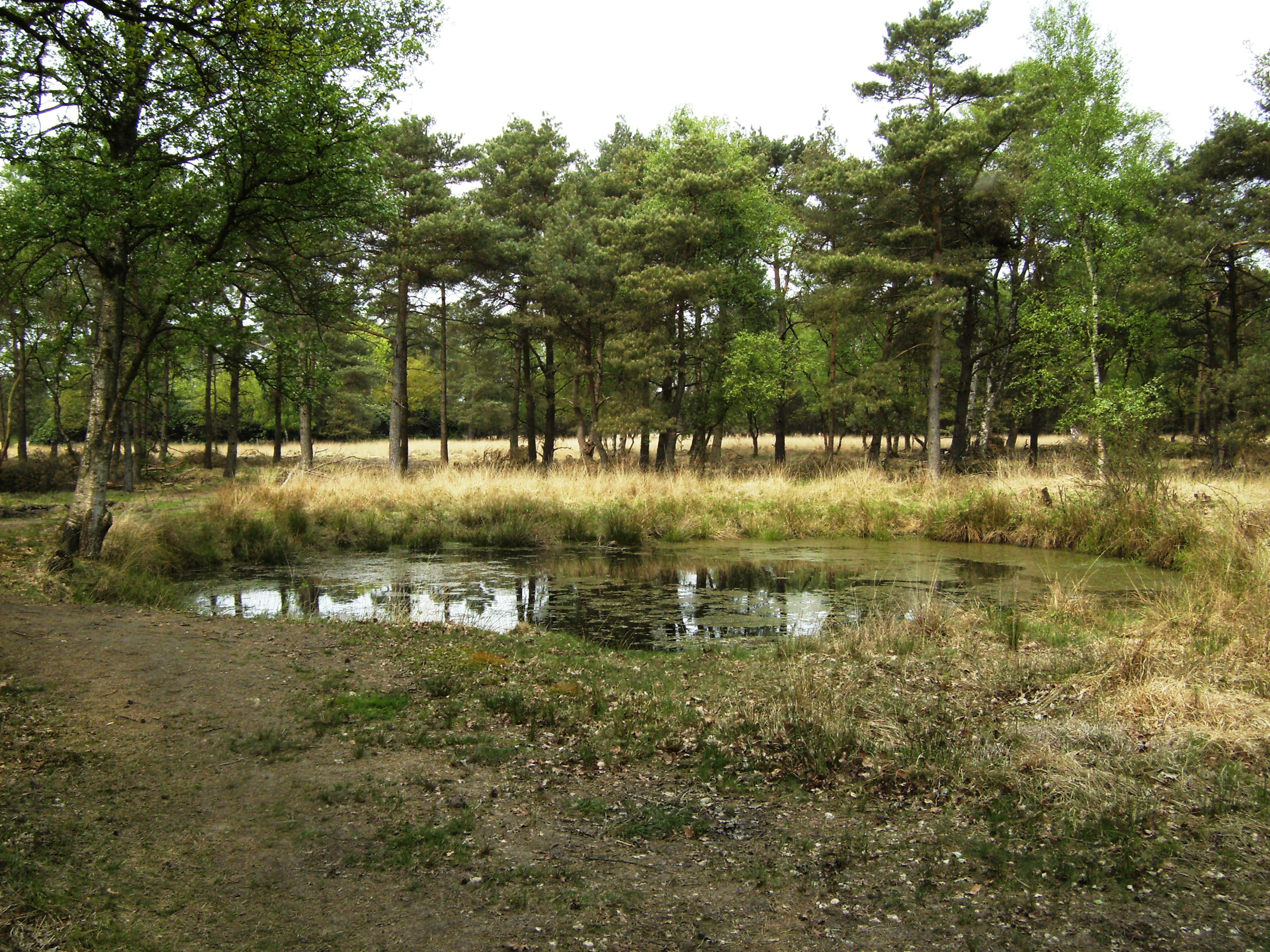
A small pond sits in the foreground with grasses and pine trees in the background at Boetelerveld.
A tranquil pond surrounded by heathland and trees in Boetelerveld.

Boetelerveld history and protected-area timeline

Boetelerveld is historically linked to the old estate of Schoonheten, which is why the area is sometimes still referred to as Schoonheterheide. Until well into the twentieth century it remained open, unfarmed heathland typical of the higher sand soils of eastern Netherlands.

In 1953 the area was scheduled to be reclaimed and converted to agricultural use. The catastrophic North Sea flood of that same year, the so-called watersnoodramp, redirected national attention and resources toward disaster recovery in Zeeland, and Boetelerveld was never ploughed. As a result, the reserve survived into the later twentieth century as one of the last intact wet heath complexes in the Salland region. The heath nevertheless became increasingly affected by encroaching pine, both self-sown fly pines on the open heath and historical plantation forest along the edges, and by drying out caused by changes in the surrounding water system.

In 2018 a management plan was adopted calling for the large-scale removal of pine forest and the reopening of the heath. The plan also envisaged removal of nutrient-rich topsoil in selected locations to encourage more species-poor, acid heath and wet heath conditions, and the infilling of ditches in surrounding land to raise water levels inside the reserve. Beginning in 2020, significant areas of conifer were removed to reintroduce open heath and to reverse decades of woodland succession on the former wet heathland.

Boetelerveld landscape and geographic character

The physical landscape of Boetelerveld is shaped by old cover sands laid down during the Pleistocene, often underlain by a substantial layer of loam. Where the loam is closer to the surface, water is retained and the ground stays moist, while deeper sandy pockets drain more freely. In the lower places within this undulating terrain, organic material has accumulated over time, producing small patches of peat vegetation.

The visual character of the reserve is a mosaic. Open purple-tinged stretches of dry and wet heath alternate with darker blocks of conifer, particularly Scots pine stands. Self-seeded fly pines have long colonised parts of the heath, and many of these have been removed in the early twenty-first century as part of restoration work. Along the edges of the elongated reserve, older planted woodland of Scots pine, birch and oak forms a transition to the surrounding agricultural landscape.

A string of small pools runs through the reserve. The largest of these, the Rietgat, is a more open body of water accompanied by a bird observation hut. The overall impression is one of a relatively quiet, undulating heathland set within an agricultural region, broken by patches of woodland and interspersed with small water features. Aircraft from nearby flight paths occasionally pass high overhead, but on the ground the reserve is noted for its stillness.

Boetelerveld ecosystems, habitats, and plant life

Ecologically, Boetelerveld is defined by the surviving wet heath habitat that gives the reserve its conservation value, including small remnants of blue moor grass vegetation. The heath is nutrient-poor and acidic, and it supports a characteristic set of specialised plants such as common gentian, tormentil, small round-leaved sundew, carnation sedge and white beak-sedge. Other notable flowering species recorded in the reserve include devil's-bit scabious, bog star (Parnassia palustris), Marsh Cinquefoil and several orchid species.

The mix of habitats supports distinctly different ecological communities within a small area. The conifer fringes and small woodland patches host forest birds, while the more open heathland carries ground-nesting and heathland species. The shallow pools, including the Rietgat, are important amphibian breeding habitat and contribute to the aquatic character of the site. Management efforts to remove pine and rewet parts of the area are intended to shift the balance back toward open wet heath so that characteristic heath-dependent flora and fauna can expand again.

Boetelerveld wildlife and species highlights

Boetelerveld is particularly important for its birdlife. The reserve supports both woodland birds and open-country or wet-landscape species, and a dedicated counting post records migration movements through the area. The Rietgat pool and the surrounding reeds are used by species such as the little grebe and other water-associated birds.

The pools are also a stronghold for amphibians. The northern crested newt, a threatened species, uses several of the reserve's pools for breeding. The moor frog, more typical of wet heath landscapes, is also present in the area. Among small mammals, the water shrew is recorded as one of the rarest inhabitants.

In summer, the heathland itself becomes the habitat of the silver-studded blue butterfly (heideblauwtje), a sedentary species closely tied to damp and wet heaths. Its presence during the warmer months is regarded as a characteristic feature of the reserve and an indicator of the quality of the surviving heath.

Boetelerveld conservation status and protection priorities

As a Natura 2000 site, Boetelerveld is part of the European network of protected natural areas and is valued for the wet heath habitat it preserves. Its conservation importance lies in being the last remaining wet heath complex within the Salland region of Overijssel, a habitat type that has declined dramatically elsewhere in the province due to afforestation, agricultural reclamation and changes in water management.

The reserve has been affected by two long-term pressures: woodland encroachment, mainly through pine plantation and self-sown fly pines on the open heath, and drying out caused by altered water levels in the surrounding area. Both trends work against the persistence of species-rich, open, wet heath. The 2018 management plan and the woodland removal that began in 2020 reflect an active attempt to reverse those trends, by reducing conifer cover, removing nutrient-rich topsoil locally and overlying wetter conditions to restore more dynamic wet heath.

Beef cattle from a herd of Scottish Highland cattle were used for grazing for many years, helping to keep the heath open. The management is carried out by the regional nature organisation Landschap Overijssel, which treats Boetelerveld as a key piece of the broader Overijssel conservation network, neighbouring other significant protected landscapes such as the Sallandse Heuvelrug to the east.

Boetelerveld cultural meaning and human context

The historical link between Boetelerveld and the old Schoonheten estate, an Overijssel havezate of regional historical importance, lives on in the alternative name Schoonheterheide. The area has not been formally settled, but it is framed by an old cultural landscape of agricultural land, quiet country lanes, small hamlets and dispersed farms typical of Salland.

The reserves' traditional footpaths, including routes through the Kloosterdijk and Eekwielensweg entrances, connect the site to older rural walking patterns in the region. Today the reserve is mainly experienced as a destination for quiet recreation, nature study and birdwatching rather than as a landscape with dense built heritage. Walking-only access and the limited network of marked routes underline this restrained, contemplative role within the surrounding agricultural landscape.

Top sights and standout views in Boetelerveld

Boetelerveld combines unusually high habitat diversity for its small size with significant regional rarity. It is the last surviving wet heath complex in Salland, holding remnants of blue moor grass vegetation alongside richer dry heath.

Highlights include the Rietgat pool with its bird observation hut, a network of small breeding pools used by the northern crested newt, a spring and summer display of heathland flora such as gentian, sundew and orchids, and the seasonal presence of the silver-studded blue butterfly. The active conversion of former pine stands into open heath is itself a distinctive feature of the reserve's current conservation story.

Best time to visit Boetelerveld

Late spring and summer are the most rewarding period to visit, when the heath is in flower and orchids, gentians and sundews can be observed. These months also bring the silver-studded blue butterfly onto the wing and are the best window for seeing amphibians around the breeding pools, while bird activity around the Rietgat remains high.

For quieter birdwatching, early mornings in spring and autumn migration periods bring peak activity at the observation hut. The reserve is foot-only and relatively exposed, so visits during daylight hours in mild weather are usually most pleasant. The woodland removal works under way since 2020 may alter access to some parts of the reserve, so visitors should expect an actively managed landscape rather than a fully finished one for the foreseeable future.

Monthly climate preview

Long-term monthly temperature and precipitation data for Boetelerveld

Boetelerveld Climate Normals and Measured Annual Temperature Patterns

Historical climate records for Boetelerveld reveal a measured annual temperature range from sub-zero winter minimums to warm summer maximums alongside steady daily precipitation. Analyzing the complete twelve-month weather profile clarifies long-term thermal rhythms and moisture distribution across the representative coordinate.
Annual mean10 °C
2 °C18 °C
Jan
Feb
Mar
Apr
May13°
Jun16°
Jul18°
Aug18°
Sep15°
Oct10°
Nov
Dec
Warmest month
July

18 °C

Coolest month
January

2 °C

Wettest month
December

2.5 mm/day

Driest month
April

1.4 mm/day

Park location guide

Geography guide, regional context, and park location map for Boetelerveld

Boetelerveld park geography, regions, and map view in Netherlands

Understand where Boetelerveld sits in Netherlands through a broader geographic reading of the surrounding landscape, nearby location context, and its mapped position within the national park landscape.

How Boetelerveld fits into Netherlands

The Netherlands is a low-lying coastal country in Northwestern Europe, famous for its extensive dike and canal systems that reclaim land from the sea. It consists of twelve provinces and is known for tulips, windmills, and cycling culture. The country is a founding member of the European Union with Amsterdam as its capital and The Hague as the seat of government.

Wider geography shaping Boetelerveld in Netherlands

The Netherlands is located in Northwestern Europe along the North Sea coastline to the north and west. It borders Germany to the east and Belgium to the south. The country is notably flat, with a significant portion of its territory lying below sea level, protected by dikes and dune systems. It consists of twelve provinces and also includes overseas municipalities in the Caribbean.

Map view of Boetelerveld

Use this park location map to pinpoint Boetelerveld in Netherlands, understand its exact geographic position, and read its mapped placement within the surrounding landscape more clearly.

Pigeon | © OpenStreetMap contributors

Location context for Boetelerveld

Overijssel

Explore detailed imagery of sandy soils, pine borders, and rare damp heathland environments.

Boetelerveld Photos and Landscape Scenery: Visualizing Protected Wet Heath Habitats

Visual documentation captures the undulating sandy terrain, open purple heath patches, and peat-fed water features defining Boetelerveld. Examining these protected area photographs reveals the unique mosaic of woodland fringes and rare wetland habitats supporting local wildlife.

A small pond sits in the foreground with grasses and pine trees in the background at Boetelerveld.

A dirt path curves through a nature reserve where large piles of stacked logs and cleared wood debris are arranged on either side, with a single standing tree in the distance under a blue sky.

Park atlas

Compare regional protected areas and surrounding sandy soil habitats

Explore Parks Near Boetelerveld and Related Protected Landscapes

Continue geographic discovery by comparing protected areas near Boetelerveld and other regional nature reserves. Examining adjacent terrain helps place local wet heath ecosystems within the broader Overijssel conservation network.
Watercolor painting showing green hills, a lake, and distant mountains under a light sky
National parkOverijssel
2.8 km away#1 closest

Southeast

Sallandse Heuvelrug National Park: Overijssel's Glacial Ridge Protected Landscape

Explore its heathland geography and mapped park boundaries.

Sallandse Heuvelrug National Park represents a significant protected landscape within Overijssel, Netherlands, notable for its distinctive glacial ridges and extensive heathland ecosystems. As one of the country's most important conservation areas, it offers a unique opportunity to study the mapped topography and the geography of Dutch heathlands. Discover the protected area's contours and its place within the broader regional atlas context, appreciating its geological formations and ecological importance.

Area
35 km²
Established
2004
IUCN
II
Relief
Upland
Nature reserveOverijssel
11 km away#2 closest

East

Wierdense Veld Nature Reserve: Geographic Overview and Protected Landscape Mapping

Raised bog and heathland restoration in Overijssel

Wierdense Veld represents a complex protected area in the Overijssel province, defined by its efforts to sustain raised bog remnants alongside a working water catchment. The landscape is a vital study of Dutch sandy soil ecology, featuring a delicate balance of sphagnum mosses, heath transitions, and essential water management practices that maintain regional biodiversity.

Area
4.2 km²
Established
1968
Relief
Lowland
Climate
Temperate
Watercolor painting of a wide landscape with clusters of trees, green meadows, and soft, distant hills under a pastel sky.
Nature reserveOverijssel
About 12 km away#3 closest

Southeast

Borkeld Nature Reserve: Overijssel Protected Landscape and Geographic Atlas

Heathland, juniper shrubland, and prehistoric archaeological terrain

Discover the geographic character of the Borkeld nature reserve in Overijssel. This protected area stands out for its large juniper shrubland, unique clay pit habitats, and deep archaeological history preserved within a gently rolling landscape of forest and heath.

Area
6 km²
Relief
Upland
Climate
Temperate
Access
Easy access
Protected areaNetherlands
18 km away#4 closest

Southwest

Veluwe: A Comprehensive Geographic Atlas of the Central Netherlands Protected Area

Glacial moraines, heathlands, and inland sand systems

Investigate the Veluwe, a premier protected area in the Gelderland province characterized by its historic push moraines and extensive ecological zones. The region encompasses significant sand drift complexes, dense woodlands, and vital spring-fed streams, offering a clear view of the diverse natural terrain found throughout the central Netherlands.

Area
1,000 km²
Relief
Upland
Climate
Temperate
Access
Easy access
Nature reserveOverijssel
23 km away#5 closest

Northeast

Engbertsdijksvenen Nature Reserve: Mapping Dutch Raised Bog and Peatland Landscapes

Protected high moor geography in the Overijssel region

Engbertsdijksvenen is a significant nature reserve in the eastern Netherlands, renowned for its extensive living raised bog and diverse peatland habitats. The site showcases a rare mosaic of open water, heathland, and bog forest, serving as a landmark for ecological restoration and wetland geography in the province of Overijssel.

Area
10 km²
Relief
Upland
Climate
Temperate
Access
Easy access
Nature reserveGelderland
27 km away#6 closest

Southwest

Landgoederen Brummen Nature Reserve: Protected Landscape and Geographic Atlas Entry

Ecological transition zone in the Gelderland province

Landgoederen Brummen showcases a rare geological intersection in the Netherlands where Veluwe sand ridges meet IJssel river clays. This protected area features a unique concentration of seepage-fed pools, blue grasslands, and alluvial alder forests, demonstrating how centuries of estate management coexist with preserved wild habitat remnants.

Area
6.77 km²
Established
2013
Relief
Lowland
Climate
Temperate
Nature reserveGelderland
28 km away#7 closest

South

Stelkampsveld Protected Nature Reserve and Restored Achterhoek Kampenlandschap in Gelderland

Tracing the mapped boundaries of historic heath and fen ecosystems

Stelkampsveld acts as an ecologically distinctive protected area in the eastern Netherlands. Covering 102 hectares, the terrain showcases a recovered mosaic of hedgerows, small enclosed fields, and re-established wetlands. The site is recognized for its botanical diversity, including rare orchid and moss species within the broader Natura 2000 network of Gelderland.

Area
1.02 km²
Established
2013
Relief
Lowland
Climate
Temperate
Nature reserveNetherlands
About 32 km away#8 closest

Northwest

Olde Maten en Veerslootlanden Nature Reserve: Peatland and Strip Field Atlas

A preserved Natura 2000 cultural landscape in Overijssel

Discover the narrow pipe shaped parcels of Olde Maten en Veerslootlanden, a uniquely preserved peat meadow reserve in the eastern Netherlands. The landscape features a high concentration of alder woodlands, species rich ditches, and historic duck decoys that define this significant regional ecosystem.

Area
7.95 km²
Established
2013
Relief
Lowland
Scope
Terrestrial

Common questions about visiting, size, designation, and location context for Boetelerveld

Boetelerveld FAQs for park facts, access, geography, and protected area context

Find quick answers about Boetelerveld, including protected-area facts, park geography, trail and visitor context, and how the park fits into its surrounding country and regional landscape.
MoriAtlas Explorer

Continue Your Protected Areas Search Across the Global Atlas

Deepen your exploration by continuing the structured search for national parks and protected areas worldwide. Utilize the comprehensive filtering capabilities to compare different conservation landscapes and refine your understanding of global park geography. Discover more about the distribution and characteristics of protected natural areas.

Global natural geography