
Mori Atlas logo
Nature reserveBermershube bei Heisterberg

Examining the ecological geography and upland woodland mosaic of this protected Hessian site

Bermershube bei Heisterberg Nature Reserve: Mapped Protected Landscapes in the Hoher Westerwald

The Bermershube bei Heisterberg nature reserve serves as an ecologically significant upland site within the German state of Hessen. Situated on the Hoher Westerwald plateau, this triangular protected area features a unique mosaic of deciduous forest, floodplain meadows, and natural spring seepage zones. This site provides a critical study of how small-scale habitat diversity and moist forest floor conditions form a dense, resilient ecological community within a broader high-plateau landscape.

nature reserveNaturschutzgebietwet meadowdeciduous forestslope forestspring seepage
A flat-style digital illustration of a mountain valley, featuring evergreen trees in the foreground, a river flowing through a meadow, a distant waterfall, and high mountain peaks under a soft sun.

Bermershube bei Heisterberg

Nature reserve

Park overview

Structured park overview, official facts, and landscape profile for Bermershube bei Heisterberg Nature Reserve

Bermershube bei Heisterberg Nature Reserve park facts, protected area profile, and essential visitor context

Review the core facts for Bermershube bei Heisterberg Nature Reserve, including designation, size, terrain, visitor scale, habitats, and operating context in one park-focused overview.

About Bermershube bei Heisterberg Nature Reserve

Bermershube bei Heisterberg is a compact but ecologically rich nature reserve in the Hoher Westerwald, a high plateau region of the Westerwald range in central-western Hesse. Despite covering less than 50 hectares, the reserve concentrates a striking variety of upland habitat types within a clearly bounded triangular area south of the village of Heisterberg. The site is ringed by roads: the federal B255 road runs along its southern edge while the local Kreisstraße K83, known locally as Ambachstraße, frames it to the east and west, giving the protected area a distinctive, easily visualized footprint on the landscape.

The reserve sits between roughly 580 and 612 meters above sea level, placing it firmly within the cool, moist upland environment typical of the higher Westerwald. This elevation matters ecologically: the cool temperatures, persistent groundwater influence from natural spring seepage, and relatively undisturbed forest cover create conditions that are increasingly rare in surrounding landscapes shaped by forestry and agriculture. The Hoher Westerwald region as a whole has been recognized through European designations, and Bermershube forms a defined piece of the broader Hoher Westerwald FFH site and the matching European bird protection area.

What most distinguishes Bermershube is the ecological mix compressed into a small area. The wet meadows and brookside floodplain along the Amdorf bach provide open, water-influenced habitat, while the surrounding deciduous forest occupies most of the protected area. The presence of numerous spring seepage points means the forest floor alternates between permanently wet, boggy patches and drier stations, generating microhabitats for moisture-loving plants, amphibians, and invertebrates. Because management deliberately leaves the woodland largely to natural processes, the reserve has also become a small refuge for slope woodland communities that have been greatly reduced across central Germany.

Beyond its ecological value, the reserve illustrates the patchwork character of German nature conservation: even tiny, road-framed plots in otherwise heavily used countryside can preserve meaningful examples of disappearing upland habitats. Within the Lahn-Dill district, where many nature reserves focus on surviving fragments of woodland, meadow, and traditional cultural landscape, Bermershube stands out for combining all three within a single protected unit.

Quick facts and research context for Bermershube bei Heisterberg Nature Reserve

Bermershube bei Heisterberg is a nature reserve (Naturschutzgebiet) in the municipality of Driedorf, Lahn-Dill district, Hesse. It covers an area of about 44.85 hectares at elevations between roughly 580 and 612 meters, averaging around 600 meters. The reserve was placed under protection on 3 December 1984, classified under IUCN Category IV as a Habitat/Species Management Area, and is administered by the Regierungspräsidium Gießen as the upper nature protection authority. It forms part of the FFH site Hoher Westerwald (5314-301) and the European bird protection area Hoher Westerwald (5314-450).

Protection and recognition

Explore documented terrestrial protection parameters, management scope, and recognition data.

Bermershube bei Heisterberg Protection Status and International Recognition Data

Bermershube bei Heisterberg maintains a documented terrestrial protection status within the global protected area network. Structured geographic records outline management parameters and formal designation data for conservation tracking.

Protection details

Protection scope
Terrestrial
Transboundary protection
No
WDPA ID
162392
Park context

Deeper park guide and search-rich context for Bermershube bei Heisterberg Nature Reserve

Bermershube bei Heisterberg Nature Reserve history, landscape, wildlife, and travel context

Explore Bermershube bei Heisterberg Nature Reserve through its history, landscape character, ecosystems, wildlife, conservation priorities, cultural context, and seasonal travel timing in a structured park guide built for atlas discovery and search intent.

Why Bermershube bei Heisterberg Nature Reserve stands out

The reserve is especially known for combining a small, near-natural wet meadow with extensive old deciduous forest that has developed largely free of human disturbance for a long period. This includes a notable occurrence of the rare Rasenschmielen-Ahorn slope forest (a silver-grass and sycamore ravine woodland community). Numerous spring seepage points sustain constantly moist and boggy conditions alongside drier sites, amplifying habitat variety across the protected area.
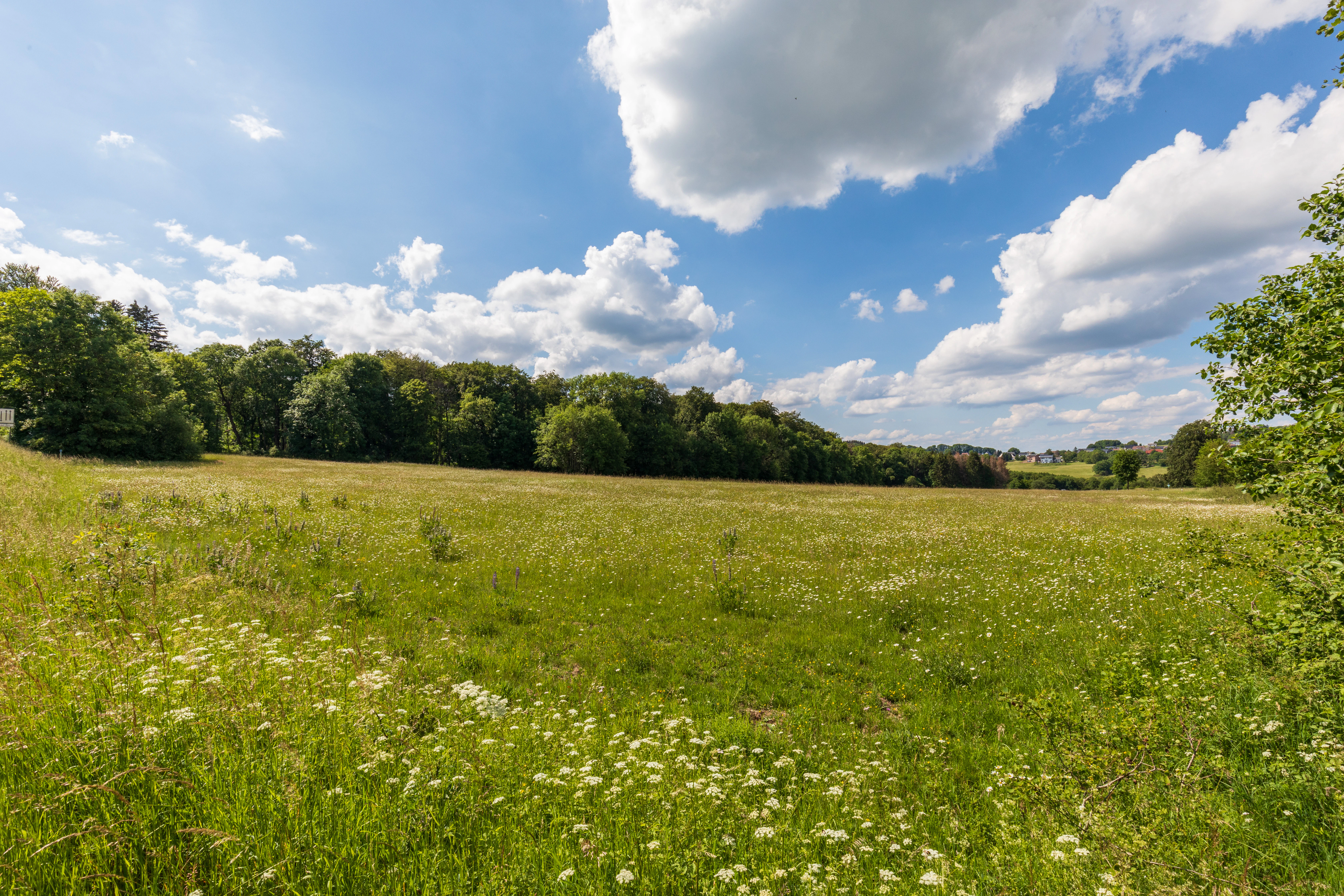
An expansive green meadow filled with wildflowers under a blue sky with white clouds, bordered by a dense line of trees in the background.
A view of the open meadows and bordering deciduous forest at the Bermershube bei Heisterberg nature reserve.

Bermershube bei Heisterberg Nature Reserve history and protected-area timeline

The Bermershube bei Heisterberg area was formally protected on 3 December 1984 as a Naturschutzgebiet under Hessian nature protection law, receiving the designation number 1532015. Its classification as an IUCN Category IV Habitat/Species Management Area reflects its role in maintaining specific habitat types rather than as a strict wilderness reserve.

In 2013, a management plan was drawn up for the broader FFH site Hoher Westerwald, which includes the Bermershube reserve as part of its overall area. Under this plan, only the open grassland and wet fallow areas are subject to a single annual cut regime intended to maintain meadow character, while the deciduous forest sections are explicitly excluded from active intervention and left to develop naturally.

Bermershube bei Heisterberg Nature Reserve landscape and geographic character

The reserve occupies a high upland site on the Hoher Westerwald plateau, with elevations broadly between 580 and 612 meters and an average around 600 meters above sea level. The protected area is shaped like a triangle defined by the surrounding road network: the Bundesstraße B255 borders it along the south, while the Kreisstraße K83, locally called Ambachstraße, runs along the eastern and western edges before converging back toward the village of Heisterberg to the north.

Within this triangular boundary, the landscape combines several distinct but closely juxtaposed physical features. A wet meadow occupies part of the area near the Amdorf brook, which drains part of the plateau. The rest of the reserve is largely covered by deciduous woodland that climbs gently across the plateau's subtle topography. Throughout the area, natural spring seepage points break through the surface, creating continuously wet and boggy patches amid generally moist forest floor conditions. These seepage features also form a small, naturally created amphibian pond visible in the landscape.

The result is a small upland mosaic where open grassland, floodplain meadow along the brook, slope forest, and spring-fed wetland all occur within close proximity. The cool, relatively humid upland climate further shapes how soils, vegetation, and water interact across the reserve.
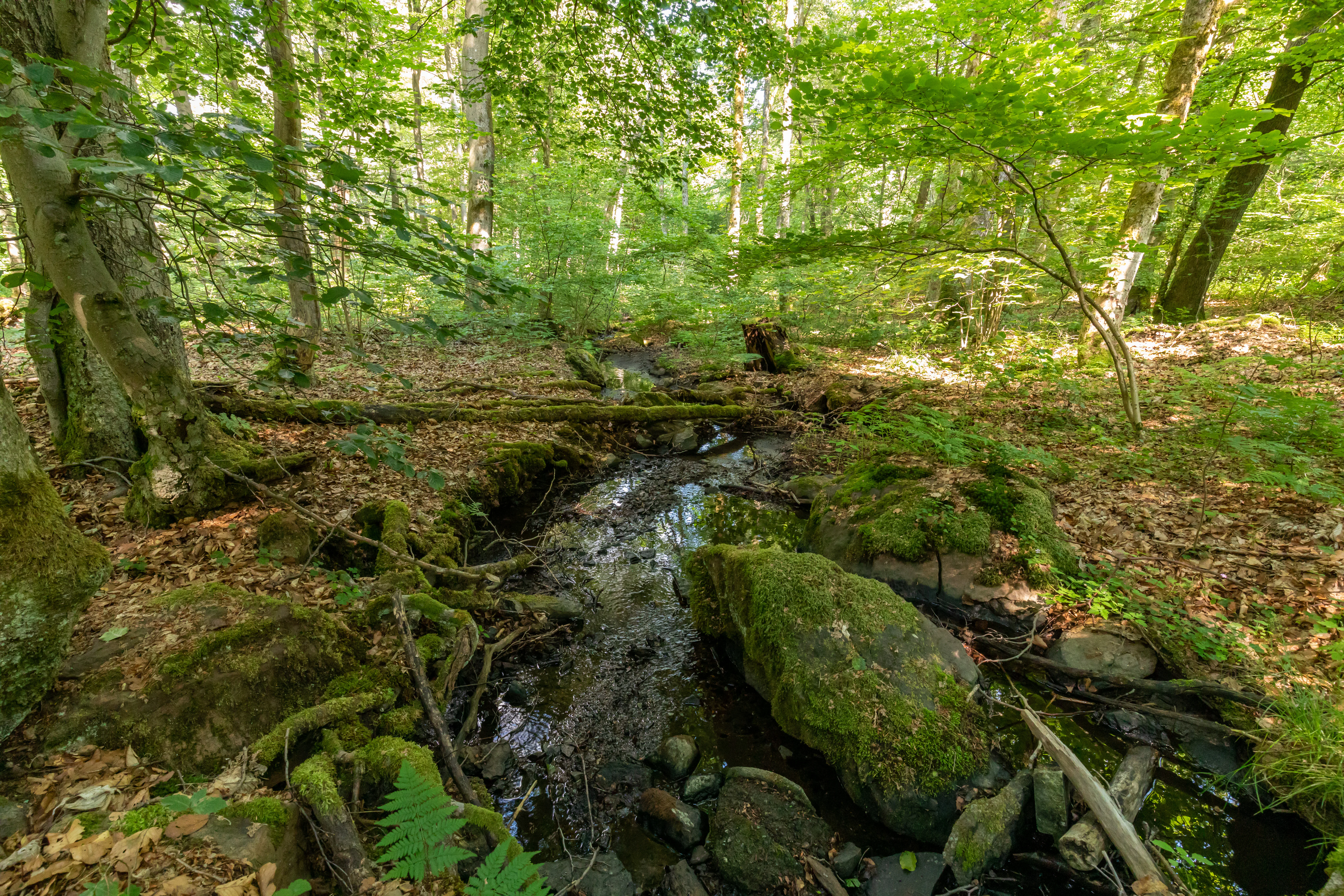
A narrow forest stream flows over mossy rocks through a lush, green deciduous forest.
A small woodland stream flowing through the forest at Bermershube bei Heisterberg.

Bermershube bei Heisterberg Nature Reserve ecosystems, habitats, and plant life

Ecologically, Bermershube is defined by the contrast and interweaving of wet and dry habitats on a high upland plateau. The wet meadows, the floodplain meadows running along the Amdorf bach, and the fragmented boggy areas around spring seepage points give the open parts of the reserve their character. These water-influenced habitats support a suite of rare plant species adapted to permanently moist or peaty conditions.

The wooded majority of the reserve is dominated by deciduous trees, with the Rasenschmielen-Ahorn slope forest, a community featuring silver grass (Deschampsia cespitosa) and sycamore maple, considered particularly noteworthy. This slope woodland community has developed with little interference from clearance or forestry, which is unusual in an otherwise heavily used central German upland region.

The juxtaposition of moist seepage zones alongside drier forest patches creates a complex microtopography of habitat. The reserve has been integrated into the wider European ecological network both as part of the Hoher Westerwald FFH site (5314-301) and the matching bird protection area (5314-450), giving its local habitat mosaic a transnational ecological context.
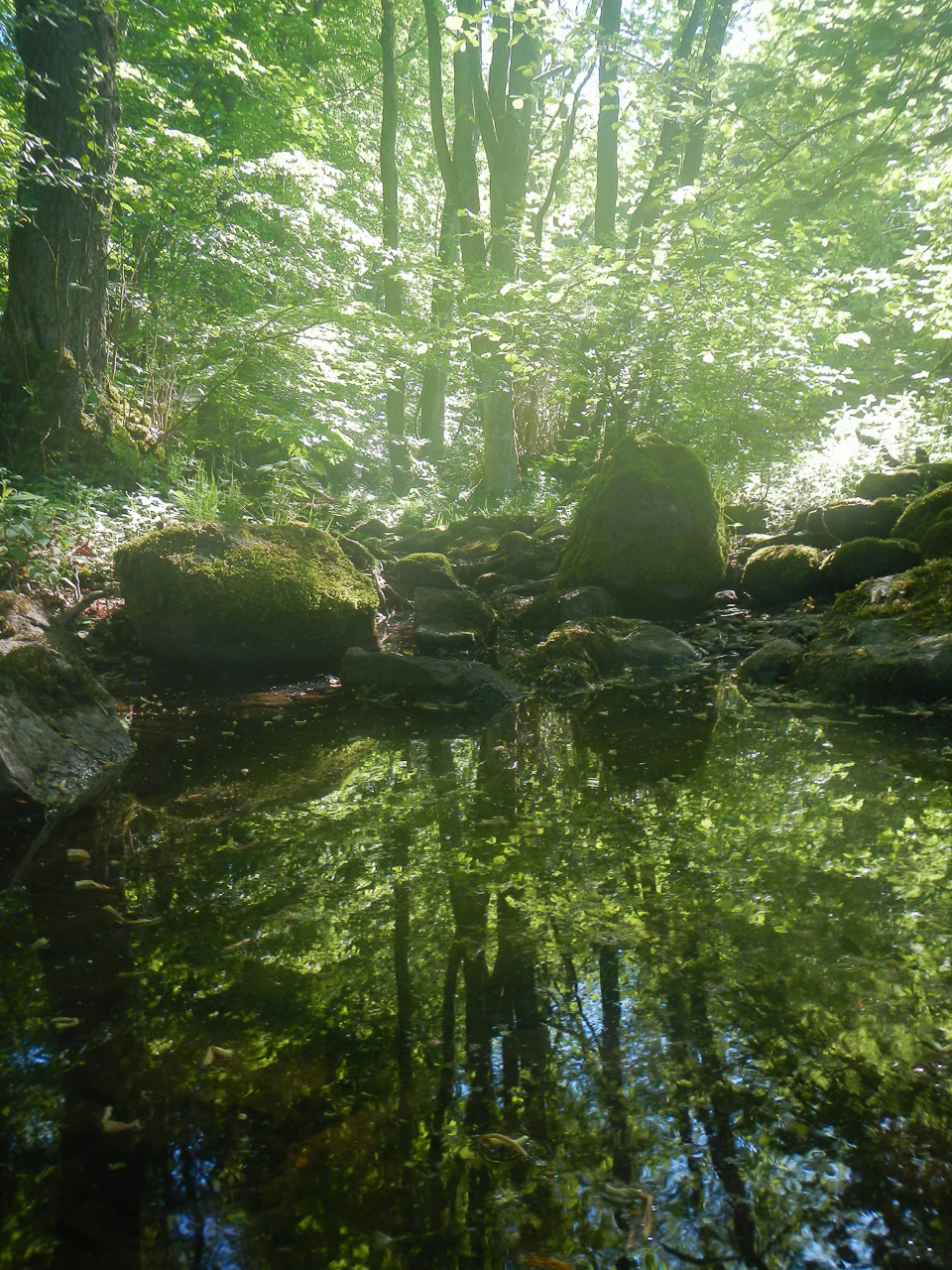
A small, still pool of water in a forest, reflecting the dense canopy and surrounding tree trunks, with mossy rocks positioned along the water's edge.
A shaded forest pool at the Bermershube nature reserve.

Bermershube bei Heisterberg Nature Reserve wildlife and species highlights

The combination of wet meadows, brookside floodplain, boggy seepage patches, and undisturbed deciduous forest creates favorable conditions for amphibians, whose life cycle needs change between water for breeding and moist terrestrial cover. The reserve's wet open habitats and naturally formed amphibian pond are central to this amphibian presence, and rare amphibians tied to these conditions have been recorded in and around the Bermershube.

Among the rarer animal species documented for the reserve are the Blauschillernder Feuerfalter (a small butterfly dependent on specific wet-meadow habitats), the Wiesenpieper (meadow pipit), the Braunkehlchen (whinchat), and the Waldschnepfe (Eurasian woodcock). These species represent a mix of meadow-ground nesting birds and a forest-ground wader, indicating both the open wet grassland character and the older deciduous woodland structure are ecologically meaningful.

The bird fauna is significant enough that Bermershube sits within the European Hoher Westerwald bird protection area, while the broader habitat diversity also supports the invertebrates and amphibians referenced in the management approach.
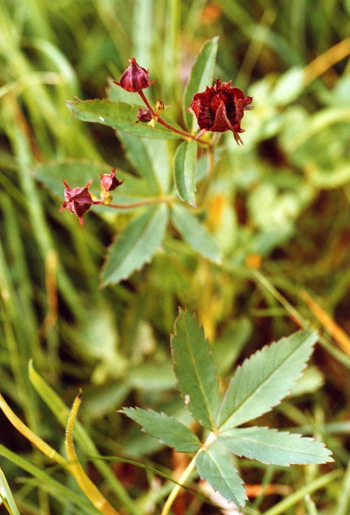
A close-up photograph of marsh cinquefoil plants with dark red, star-shaped flower buds and serrated green leaves against a blurry green grassy background.
Marsh cinquefoil (Potentilla palustris), a plant species typically found in the wet meadow habitats of the Bermershube bei Heisterberg nature reserve.

Bermershube bei Heisterberg Nature Reserve conservation status and protection priorities

Bermershube bei Heisterberg is protected as a Hessian Naturschutzgebiet, the strongest level of site-based nature protection under German federal state law, with the higher nature protection authority of Regierungspräsidium Gießen responsible for its administration. Its IUCN Category IV status reflects its purpose as a Habitat/Species Management Area, focused on maintaining specific habitat types and associated species rather than as a strict nature reserve.

The conservation value of the site lies in a combination of factors: a near-natural wet meadow with intact hydrology fed by natural springs, a substantial area of old deciduous forest developed largely without active forestry, and the presence of the rare Rasenschmielen-Ahorn slope woodland community. The diverse moisture conditions produced by multiple spring seepage points further enhance habitat variety across a small footprint.

Through its inclusion in the Hoher Westerwald FFH site (5314-301) and the matching European bird protection area (5314-450), Bermershube contributes to the Natura 2000 network. Management follows the 2013 plan for the FFH site: open grassland and wet fallows receive only a single annual cut, while the forest areas are deliberately left to develop naturally without interference.

Top sights and standout views in Bermershube bei Heisterberg Nature Reserve

Most of the reserve consists of deciduous woodland that has developed largely free of human disturbance, framing a smaller wet meadow and brookside habitat. Numerous spring seepage points create a network of permanently moist and boggy microhabitats alongside drier forest floor, generating unusually high habitat density for a 44.85 ha site. The reserve harbors rare plant species tied to wet habitats and rare woodland community types such as the Rasenschmielen-Ahorn slope forest, alongside amphibians, a rare butterfly, and characteristic open-country and forest birds.

Monthly climate preview

Trace long-term monthly temperature swings and precipitation averages across the protected terrain

Bermershube bei Heisterberg Climate Normals and Annual Weather Patterns

Bermershube bei Heisterberg records measured mean monthly temperatures ranging from sub-zero winter minimums to warm summer maximums alongside steady year-round precipitation. Reviewing the complete twelve-month climatology dataset reveals detailed shifts in baseline temperature and moisture distributions across the representative coordinate.
Annual mean9 °C
0 °C19 °C
Jan
Feb
Mar
Apr
May12°
Jun16°
Jul19°
Aug18°
Sep14°
Oct
Nov
Dec
Warmest month
July

18.5 °C

Coolest month
January

-0.4 °C

Wettest month
December

2.5 mm/day

Driest month
April

1.6 mm/day

Park location guide

Geography guide, regional context, and park location map for Bermershube bei Heisterberg Nature Reserve

Bermershube bei Heisterberg Nature Reserve park geography, regions, and map view in Germany

Understand where Bermershube bei Heisterberg Nature Reserve sits in Germany through a broader geographic reading of the surrounding landscape, nearby location context, and its mapped position within the national park landscape.

How Bermershube bei Heisterberg Nature Reserve fits into Germany

Germany is a federal republic in Western and Central Europe with a population of over 83 million across sixteen constituent states. It is Europe's largest economy by nominal GDP and a major global exporter and importer. The capital is Berlin, and the country borders Denmark, Poland, Czech Republic, Austria, Switzerland, France, Luxembourg, Belgium, and the Netherlands.

Wider geography shaping Bermershube bei Heisterberg Nature Reserve in Germany

Germany is located in Western and Central Europe, spanning 357,022 km². It borders Denmark to the north, Poland and the Czech Republic to the east, Austria and Switzerland to the south, and France, Luxembourg, Belgium, and the Netherlands to the west. The country has coastlines on the Baltic Sea and North Sea to the north, with the Alps located in the southern region.

Map view of Bermershube bei Heisterberg Nature Reserve

Use this park location map to pinpoint Bermershube bei Heisterberg Nature Reserve in Germany, understand its exact geographic position, and read its mapped placement within the surrounding landscape more clearly.

Pigeon | © OpenStreetMap contributors

Location context for Bermershube bei Heisterberg Nature Reserve

Hessen

Visualizing the upland protected forest and wet meadow habitats

Bermershube bei Heisterberg Photos and Landscape Scenery

Browse detailed photographs showcasing the complex terrain, old deciduous woodland, and spring-fed wetlands of Bermershube bei Heisterberg. Visual records help researchers examine the unique mosaic of slope forest and floodplain habitats across the Hoher Westerwald plateau.

An expansive green meadow filled with wildflowers under a blue sky with white clouds, bordered by a dense line of trees in the background.

A bright, sunlit deciduous forest with dense green foliage and tall, straight tree trunks rising from the forest floor.

A narrow forest stream flows over mossy rocks through a lush, green deciduous forest.

A small, still pool of water in a forest, reflecting the dense canopy and surrounding tree trunks, with mossy rocks positioned along the water's edge.

A close-up photograph of marsh cinquefoil plants with dark red, star-shaped flower buds and serrated green leaves against a blurry green grassy background.

Park atlas

Compare adjacent upland reserves, wet meadows, and forest ecosystems across Hesse

Parks Near Bermershube bei Heisterberg and Surrounding Protected Landscapes

Browse nearby national parks and protected areas connected to the geography of Bermershube bei Heisterberg. Comparing adjacent upland reserves and forest habitats provides broader context for Central German conservation landscapes.
A horizontal watercolor painting depicting a soft, green landscape with a winding stream through a flowery meadow and forested hills in the background.
Nature reserveHessen
About 1.5 km away#1 closest

South

Die Heck bei Hohenroth Nature Reserve: Hessen Protected Forest and Geography

High-elevation woodland habitats in the Hoher Westerwald

Located in the Lahn-Dill district, Die Heck bei Hohenroth provides a specialized look at Mittelgebirge ecology. The reserve functions as a node within European conservation networks, protecting a mosaic of wet and dry forest patches that support rare lichens, fungi, and native bird populations across its rolling upland terrain.

Area
0.204 km²
Established
1998
IUCN
IV
A horizontal watercolor painting depicting a soft, impressionistic landscape with rolling hills in the background and a line of green trees and meadow in the foreground.
Nature reserveHessen
About 2.3 km away#2 closest

Northwest

Feuerheck bei Waldaubach Nature Reserve: Upland Forest and Habitat Geography in Hessen

Protected broadleaf woodland landscapes and high-elevation habitat patterns.

Located in the German central highlands of Hessen, Feuerheck bei Waldaubach stands as a meticulously protected 24-hectare nature reserve. The site features a sophisticated interplay of deciduous woodland and moist meadow clearings, driven by high annual rainfall and varied soil conditions. This atlas entry provides essential data on the reserve's topography, forest management status, and its role as a key habitat for specialized invertebrates and woodland birds.

Area
0.244 km²
Established
1984
IUCN
IV
A soft watercolor painting showing green rolling hills in the foreground and faded purple and yellow mountain silhouettes against a white background.
Nature reserveRhineland-Palatinate
About 3.8 km away#3 closest

West

Fuchskaute Nature Reserve: Topographic Atlas and Protected Landscape Overview

Highland basalt summit of the Westerwald range in Rhineland-Palatinate

Fuchskaute represents a primary geographic landmark and nature reserve in the Hoher Westerwald. The site features an ancient, erosion-resistant basalt cap that supports rare upland heaths and species-rich meadows, distinct from the surrounding Devonian sediments. Our atlas data tracks its complex overlapping conservation status and provides a clear view of its summit plateau and surrounding hydrographic networks.

Area
0.402 km²
Established
1984
Relief
Mountain
Climate
Temperate
A watercolor illustration of a forest edge with trees, mossy rocks, and ferns, featuring a soft, bright, and airy color palette.
Nature reserveHessen
About 4.1 km away#4 closest

North

Rabenscheider Holz Nature Reserve: Protected Landscapes and Stream Valleys in Hessen

Westerwald upland terrain and diverse woodland habitats

Rabenscheider Holz preserves a vital cross-section of Westerwald habitats, integrating mature broadleaf forests and traditionally managed grasslands. This nature reserve serves as an ecological anchor within the Ketzerbach stream valley, maintaining important woodland and meadow biodiversity in the state of Hessen.

Area
0.573 km²
Established
1994
IUCN
IV
A soft, painterly watercolor illustration of a rolling green landscape with a gentle stream or wetland area in the foreground and rounded hills in the background.
Nature reserveHessen
About 4.7 km away#5 closest

North

Aubachtal bei Rabenscheid Nature Reserve: Mapped Geography and Protected Area Data

A primary stream-valley habitat within the Hessen region

Aubachtal bei Rabenscheid offers a detailed look at a high-quality nature reserve in the Lahn-Dill-Kreis area of Hessen. The landscape is defined by the narrow valley of the Aubach, which supports a complex mosaic of wet meadows, alder swamp woodlands, and sedge mires. This site functions as a significant ecological refuge, contributing to the broader European network of protected areas through its distinct biodiversity and clean-water stream ecosystems.

Area
0.63 km²
Established
1984
IUCN
IV
Relief
Upland
Watercolor painting of a soft, hazy landscape featuring rolling green hills, distant mountains, and water in the foreground.
Nature reserveWesterwaldkreis
About 4.9 km away#6 closest

West

Breitenbachtalsperre Nature Reserve: Geography and Protected Habitat Mapping in Westerwaldkreis

Managed wetland and reservoir landscape in western Germany

Breitenbachtalsperre protects an important reservoir ecosystem, including shallow margins and wet meadows near Waigandshain. This nature reserve provides a focused look at habitat management in the Westerwald, where stream-fed waters sustain diverse plant societies and wildlife in a compact, protected basin.

Area
0.47 km²
Established
1988
IUCN
IV
Nature reserveRheinland-Pfalz
About 5.7 km away#7 closest

Southwest

Wacholderheide bei Westernohe Nature Reserve Protected Area Atlas and Geographic Map Context

Juniper heathland mosaic in the German Westerwald region

Spanning 14 hectares, Wacholderheide bei Westernohe acts as a vital protected pocket of open heathland framed by dense spruce forests. The reserve supports a specialized community of arnica, common heather, and juniper, sustained by decades of consistent grazing and mechanical mowing that define its unique regional character.

Area
0.14 km²
Established
1967
IUCN
IV
A horizontal watercolor painting depicting a soft, scenic landscape of a park with rolling hills, a central body of water, and surrounding trees.
Nature reserveWesterwaldkreis
About 12 km away#8 closest

West

Bacher Lay Nature Reserve: Basalt Quarry Landscapes in Westerwaldkreis, Germany

Protected landscape with significant geological geotope features

Bacher Lay provides an informative look at a compact nature reserve formed within a former basalt quarry. Featuring the striking Pfaffenmal columnar basalt formation and a mosaic of river valley habitats, the site serves as a vital protected area in the Westerwaldkreis region for studying habitat succession and geological formations.

Area
0.447 km²
Established
1996
IUCN
IV
Relief
Upland

Common questions about visiting, size, designation, and location context for Bermershube bei Heisterberg Nature Reserve

Bermershube bei Heisterberg Nature Reserve FAQs for park facts, access, geography, and protected area context

Find quick answers about Bermershube bei Heisterberg Nature Reserve, including protected-area facts, park geography, trail and visitor context, and how the park fits into its surrounding country and regional landscape.
MoriAtlas Explorer

Continue Your Protected Areas Search Across the Global Atlas

Deepen your exploration by continuing the structured search for national parks and protected areas worldwide. Utilize the comprehensive filtering capabilities to compare different conservation landscapes and refine your understanding of global park geography. Discover more about the distribution and characteristics of protected natural areas.

Global natural geography