


Mori Atlas logo
National parkBindarri National Park

Discover the mapped boundaries and regional atlas setting of this Australian National Park.

Bindarri National Park: Protected Landscape and Geographic Context in New South Wales

Bindarri National Park represents a significant protected landscape within the broader geography of New South Wales, Australia. This page offers an atlas-centric view, detailing the park's mapped boundaries and its role as a national park. Users can explore its specific geographic context and understand its place within the regional landscape, providing a foundation for structured discovery of Australia's protected areas.

National ParksNew South WalesBiodiversity HotspotWaterfallsGreat EscarpmentRainforests
Stylized illustration of a waterfall with rocks, trees, and vegetation

Bindarri National Park

National park

Park overview

Structured park overview, official facts, and landscape profile for Bindarri National Park

Bindarri National Park park facts, protected area profile, and essential visitor context

Review the core facts for Bindarri National Park, including designation, size, terrain, visitor scale, habitats, and operating context in one park-focused overview.

About Bindarri National Park

Bindarri National Park occupies a distinctive position in the protected area network of New South Wales, combining significant biodiversity conservation with dramatic scenery derived from the Great Escarpment. The park's relatively small area belies its ecological importance, as it protects a concentration of rare and endangered species that has earned it recognition as a biodiversity hotspot. The park's establishment in 1999 represented recognition of the area's ecological values, which had previously been under pressure from various land uses. Today, the park provides permanent protection for habitats that support species with extremely limited distributions, making it important for broader regional conservation outcomes. The landscape character ranges from steep escarpment slopes carved by ancient river systems to more gentle terrain where streams have breached the main geological fault line. Visitors drawn to the park experience a landscape that feels distinctly wild, with waterfalls, dense vegetation, and rugged terrain creating a sense of naturalness despite the proximity to major population centres.

Quick facts and research context for Bindarri National Park

Bindarri National Park covers 55.95 square kilometres along the mid-north coast of New South Wales, positioned roughly midway between Sydney and Brisbane. The protected area is managed by the National Parks and Wildlife Service of New South Wales and holds IUCN Category II status as a national park. The park's defining geographic feature is the Great Escarpment, a dramatic geological boundary where the New England Plateau descends sharply toward the coastal lowlands. The Urumbilum River, descending through this escarpment, carved spectacular waterfalls before reaching its mouth within the park boundaries. Bangalore Falls represents one of the park's most accessible and visually striking waterfall features.

Protection and recognition

Analyzing the official terrestrial boundary management and global conservation database entries

Documented Protection Status and Terrestrial Designations of Bindarri National Park

Explorers can verify the official terrestrial protection scope, designation history, and documented management framework of Bindarri National Park. Tracking regional boundaries and global registry alignments provides a clear baseline to understand how the park fits into the broader network of protected landscapes.

Protection details

Protection scope
Terrestrial
Transboundary protection
No
Park context

Deeper park guide and search-rich context for Bindarri National Park

Bindarri National Park history, landscape, wildlife, and travel context

Explore Bindarri National Park through its history, landscape character, ecosystems, wildlife, conservation priorities, cultural context, and seasonal travel timing in a structured park guide built for atlas discovery and search intent.

Why Bindarri National Park stands out

Bindarri National Park is best known as an epicentre of biodiversity, protecting populations of exceptionally rare plant species including the fish bone fern, southern quassia, and palm orchid. These three species exemplify the park's significance as a conservation refuge for flora with highly restricted distributions. The park is also renowned for its dramatic escarpment landscape, where the Great Escarpment creates a scenic backdrop of cascading waterfalls, deep gorges, and rugged ridgelines. The mouth of the Urumbilum River, where it breaches the escarpment to reach the coastal plain, represents a particularly striking natural feature that showcases the park's dramatic topography.
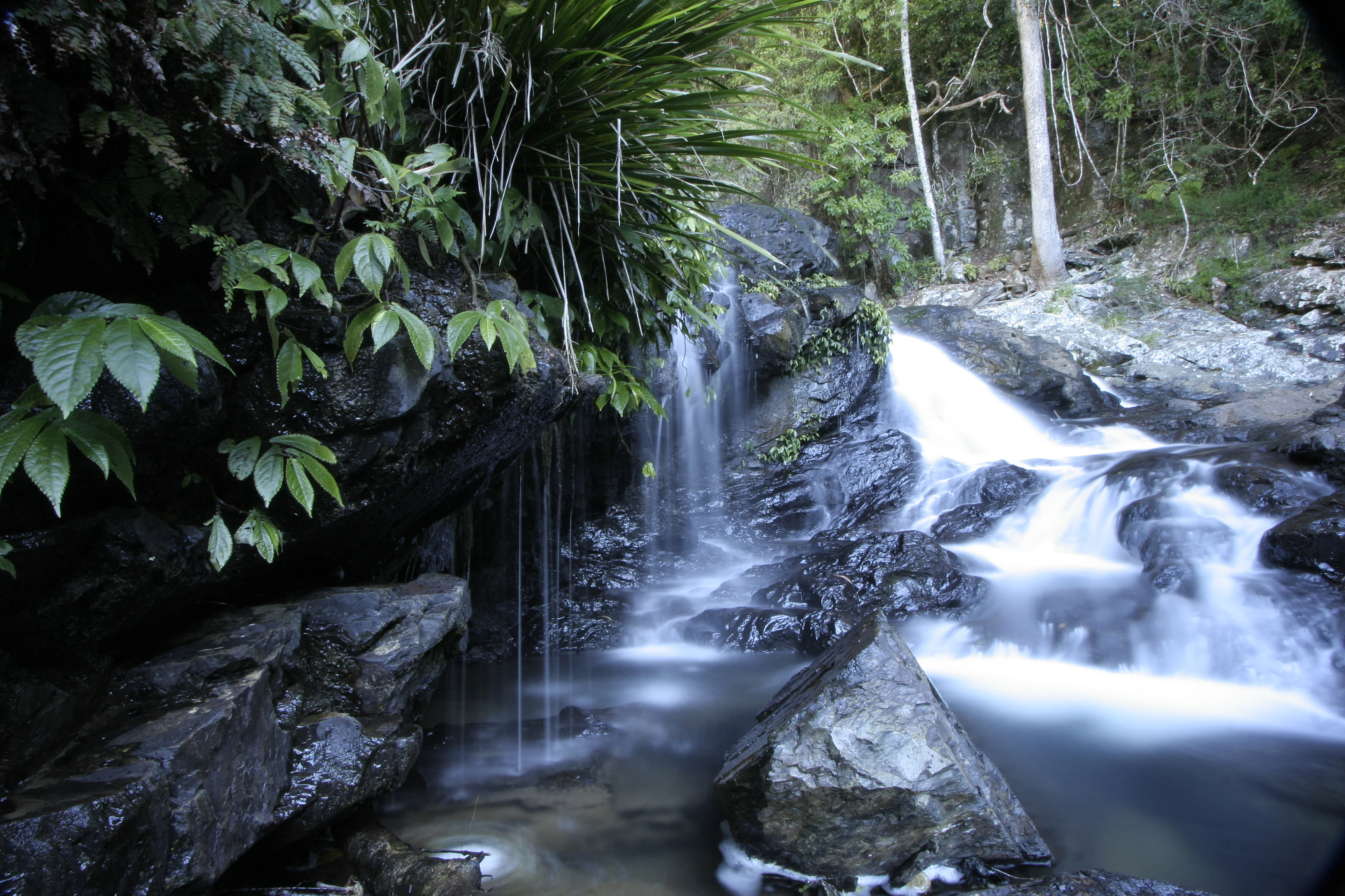
Waterfall flowing over rocky terrain with dense green vegetation on the left side
Bangalore Falls in Bindarri National Park, showcasing cascading water over dark rocks with lush green foliage

Bindarri National Park history and protected-area timeline

Bindarri National Park was formally established on 1 January 1999, making it one of the more recent additions to New South Wales's national park system. The park's creation reflected growing recognition during the late twentieth century of the ecological significance of the Great Escarpment region and the need to protect areas of exceptional biodiversity value. Prior to national park designation, the area had experienced various land uses that shaped its present character, though the steep and rugged terrain limited intensive development in many areas. The establishment of Bindarri National Park was part of a broader expansion of protected areas in northern New South Wales during the 1990s, a period when conservation planning increasingly emphasised the importance of protecting representative examples of the region's diverse ecosystems and rare species habitats.

Bindarri National Park landscape and geographic character

The landscape of Bindarri National Park is defined by the Great Escarpment, a major geological feature that marks the eastern edge of the New England Plateau. The escarpment rises abruptly from the coastal lowlands, creating a dramatic backdrop of sheer cliffs, steep ridgelines, and deeply incised valleys. The Urumbilum River has carved a spectacular course through the escarpment, descending via a series of waterfalls and cascades before reaching its mouth where it exits onto the coastal plain. Bangalore Falls provides one of the park's most accessible waterfall vantage points, where water plunges over resistant rock layers in a characteristic cascade. The interaction between the river systems and the escarpment geology creates a landscape of considerable scenic diversity, with moist gullies, exposed rock platforms, and sweeping views from elevated vantage points.

Bindarri National Park ecosystems, habitats, and plant life

The ecological character of Bindarri National Park centres on its role as a refuge for rare and threatened plant species. The park is recognised as a centre of biodiversity, supporting species with highly restricted distributions that are found in few other locations globally. The fish bone fern, southern quassia, and palm orchid represent flagship species of conservation concern within the park, each occupying specialised habitats within the diverse terrain. The combination of elevation change, varying aspect, and moisture availability creates a mosaic of microhabitats that supports this remarkable plant diversity. The moist, sheltered valleys of the escarpment provide conditions different from the surrounding lowlands, allowing species with specific environmental requirements to persist.

Bindarri National Park wildlife and species highlights

While the Wikipedia source emphasises the park's botanical significance, Bindarri National Park supports diverse wildlife associated with the tall wet forests, rocky outcrops, and riparian zones of the Great Escarpment region. Birdlife typical of New South Wales north coast forests would be expected in the park, including species associated with old-growth forest habitats. The riparian corridors along the Urumbilum River and its tributaries provide habitat for aquatic species and serve as movement pathways for fauna traversing the rugged terrain. The park's location on the coastal margin of the Great Dividing Range places it within a region of significant faunal diversity, where subtropical influences extend further south than in other parts of the continent.

Bindarri National Park conservation status and protection priorities

Bindarri National Park represents an important conservation entity in the northern New South Wales region, protecting a concentration of rare and endangered species within a relatively limited area. The presence of species such as the fish bone fern, southern quassia, and palm orchid demonstrates the park's significance for plant conservation, as these species have very restricted distributions and face threats from habitat loss and modification in unprotected areas. The establishment of the park in 1999 provided formal protection for these species and the habitats upon which they depend. As a Category II protected area, the park aims to protect ecological processes and biodiversity while also providing opportunities for appropriate visitor appreciation of the landscape's natural values.

Bindarri National Park cultural meaning and human context

The traditional Aboriginal connections to the Bindarri National Park area are not detailed in the available source material, though the broader Coffs Harbour region has evidence of continuous Aboriginal occupation spanning many thousands of years. The Great Escarpment and associated river systems would have held significance for local Aboriginal peoples, with the Urumbilum River mouth and waterfall areas likely serving as resource-rich locations for traditional activities. The absence of detailed cultural information in the source material means this aspect of the park's identity remains inadequately documented for inclusion in this profile.

Top sights and standout views in Bindarri National Park

Bangalore Falls offers visitors one of the park's most striking visual experiences, where water cascades over rock shelves in a characteristic display of the area's hydrological energy. The mouth of the Urumbilum River represents a dramatic landscape feature where the watercourse breaches the Great Escarpment and emerges onto the coastal plain, creating a memorable intersection of mountain and coast landscapes. The park's biodiversity significance, centred on rare species such as the fish bone fern, southern quassia, and palm orchid, positions Bindarri as a significant site for understanding the unique flora of northern New South Wales. The combination of scenic waterfalls, rugged escarpment terrain, and exceptional plant diversity creates a park of distinctive character.

Best time to visit Bindarri National Park

The park can be visited throughout the year, though the wetter months of late summer and autumn typically bring increased water flows to the waterfalls that are a defining feature of the park. The warm temperate climate of the Coffs Harbour region makes outdoor exploration pleasant during the cooler winter months when rainfall is typically lower. Summer storms can bring dramatic waterfall displays but may also create access limitations on some trails. The park's relatively compact size means that a visit can be comfortably accommodated in a single day, though overnight stays would allow for more thorough exploration of the trail network.

Monthly climate preview

Long-term monthly temperature and precipitation averages for New South Wales

Bindarri National Park Climate Normals and Annual Temperature Rhythm

Recorded measurements outline a steady annual temperature and precipitation rhythm across the representative park coordinate from 1991 to 2020. Reviewing the complete twelve-month climatology profile provides deeper insight into measured long-term normals.
Annual mean20 °C
15 °C24 °C
Jan24°
Feb23°
Mar22°
Apr20°
May18°
Jun16°
Jul15°
Aug16°
Sep18°
Oct19°
Nov21°
Dec22°
Warmest month
January

23.6 °C

Coolest month
July

15.1 °C

Wettest month
February

6.9 mm/day

Driest month
September

1.6 mm/day

Park location guide

Geography guide, regional context, and park location map for Bindarri National Park

Bindarri National Park park geography, regions, and map view in Australia

Understand where Bindarri National Park sits in Australia through a broader geographic reading of the surrounding landscape, nearby location context, and its mapped position within the national park landscape.

How Bindarri National Park fits into Australia

Australia is a constitutional monarchy and federal parliamentary democracy comprising six states and ten territories. With a population of nearly 28 million, it is one of the world's most urbanised countries, with most people concentrated on the eastern seaboard. The country has a high Human Development Index and is known for its cultural diversity, ancient Aboriginal heritage, and unique wildlife.

Wider geography shaping Bindarri National Park in Australia

Australia occupies the entire Australian continent, the island of Tasmania, and numerous smaller islands. It is the world's flattest and driest inhabited continent, featuring vast deserts in the interior (the Outback), tropical rainforests along the eastern coast, and a coastline bordering the Indian and Pacific Oceans.

Map view of Bindarri National Park

Use this park location map to pinpoint Bindarri National Park in Australia, understand its exact geographic position, and read its mapped placement within the surrounding landscape more clearly.

Pigeon | © OpenStreetMap contributors

Location context for Bindarri National Park

New South Wales

Examine the protected landscapes of Bindarri National Park, showcasing its dramatic Great Escarpment, unique habitats, and captivating waterfall scenery.

Bindarri National Park: A Visual Guide to its Dramatic Escarpment, Waterfalls, and Biodiversity

View comprehensive imagery of Bindarri National Park to understand its distinctive Great Escarpment landscapes, deeply carved river valleys, and spectacular waterfalls. The visual atlas provides a deeper appreciation for the park's biodiversity, unique plant habitats, and rugged, protected-area environment in New South Wales.

Waterfall flowing over rocky terrain with dense green vegetation on the left side

Park atlas

Compare diverse conservation landscapes and mapped terrain in the New South Wales region surrounding Bindarri National Park.

Explore Nearby National Parks and Protected Areas Beyond Bindarri National Park's Escarpment Landscapes

Browse a curated selection of national parks and protected areas near Bindarri National Park, tracing the varied landscapes from the Great Escarpment down to the New South Wales coastal plain. Continuing your park discovery allows for geographic comparison, revealing how protected-area networks are distributed across the region and preserving diverse ecological zones.
National parkNew South Wales
Park boundaries overlap#1 closest

Southwest

Dorrigo National Park: National Park Geography and Mapped Protected Landscape

Explore the regional context and unique geographic boundaries of this New South Wales park.

Dorrigo National Park serves as a significant protected area within the broader geographic tapestry of New South Wales. This entry offers detailed insights into its mapped boundaries and landscape characteristics, positioning it within Australia's network of national parks. Users seeking structured geographic information and an atlas-style understanding of protected lands will find valuable context here, focusing on the park's inherent natural features and regional setting.

Area
119 km²
Established
1967
IUCN
II
Relief
Highland
National parkNew South Wales
3.1 km away#2 closest

Southeast

Bongil Bongil National Park: Exploring New South Wales' Protected Landscape Identity

Mapped boundaries and regional geography of a national park.

This entry for Bongil Bongil National Park provides an atlas-focused view of its protected landscape within New South Wales. Understand the park's geographic context, its designation as a national park, and how its mapped boundaries contribute to the broader regional geography. It serves as a distinct point of entry for exploring the specific conservation lands and natural terrain that define this Australian park entity for detailed atlas-based study.

Area
42.33 km²
Established
1995
IUCN
II
Relief
Lowland
National parkNew South Wales
4.1 km away#3 closest

West

Cascade National Park: National Park in New South Wales with Mapped Protected Boundaries

Explore the unique geography and landscape context of this protected area.

Delve into Cascade National Park, a protected national park located in New South Wales, Australia. This entity is crucial for understanding the mapped geographic extent and specific landscape characteristics of one of Australia's protected natural areas. Its inclusion within the atlas provides a grounded point for examining regional conservation lands and their spatial distribution.

Area
36 km²
Established
1999
IUCN
II
Climate
Temperate
Nature reserveNew South Wales
About 6.8 km away#4 closest

Northeast

Coramba Nature Reserve: Protected Lowland Rainforest Geography in New South Wales

A vital forest fragment in the Clarence River valley

Coramba Nature Reserve stands as a significant ecological sanctuary in coastal New South Wales. This protected area preserves a rare lowland sub-tropical rainforest, serving as an important reference site for botanical study and forest conservation within the broader geography of the Clarence River valley region.

Area
0.094 km²
Established
1982
IUCN
IV
Relief
Lowland
National parkNew South Wales
9.5 km away#5 closest

East

Ulidarra National Park: New South Wales Strict Nature Reserve and Wildlife Sanctuary

Explore its elevation range, mapped forest ecosystems, and protected habitats.

Ulidarra National Park represents a small yet ecologically vital protected area within New South Wales, Australia. Classified as a strict nature reserve, it preserves significant old-growth eucalyptus forests and intact rainforests across a notable elevation gradient. The park is recognized for providing critical habitat for species like koalas and various native birds, making it a key site for understanding regional wildlife diversity and protected landscape conservation through detailed mapping and geographic context.

Area
6.8 km²
Established
1999
IUCN
Ia
Relief
Mixed relief
National parkNew South Wales
14 km away#6 closest

West

Junuy Juluum National Park: New South Wales Protected Forest Remnant Exploration

Discover rare warm temperate rainforest and unique Australian birdlife.

Junuy Juluum National Park offers a vital glimpse into a rare warm temperate rainforest habitat within New South Wales. Situated on Campion Mountain, this protected area showcases a distinct forest ecosystem, contrasting sharply with the surrounding eucalypt woodlands and cleared agricultural lands. Its mapped geography and status as a protected forest remnant make it significant for understanding regional conservation landscapes and unique Australian birdlife.

Area
9 km²
Established
1999
IUCN
II
Relief
Mountain
National parkNew South Wales
15 km away#7 closest

Northwest

Nymboi-Binderay National Park: Protected Landscape in New South Wales

Explore its mapped boundaries and regional natural geography.

Nymboi-Binderay National Park stands as a protected natural landscape within New South Wales, Australia, offering valuable geographic context for atlas explorers. This entry focuses on its identity as a national park, providing insights into its mapped protected area and its position within the broader regional geography of New South Wales, enabling structured discovery of its natural landscape features.

Area
172.43 km²
Established
1997
IUCN
II
Relief
Upland
National parkNew South Wales
16 km away#8 closest

Southwest

Bellinger River National Park: Protected River Landscape and Forested Terrain in New South Wales

Explore mapped boundaries and geographic context.

Bellinger River National Park is a protected national park situated in New South Wales, Australia, renowned for its untouched upper river catchment and dense old-growth forests. The park offers valuable insights into the region's natural geography, featuring steep valleys, numerous waterfalls, and a significant river corridor. This page provides detailed information on its protected landscape, mapped boundaries, and geographic setting, essential for atlas-style discovery and understanding its ecological significance.

Area
28.3 km²
Established
1997
IUCN
II
Relief
Mixed relief

Common questions about visiting, size, designation, and location context for Bindarri National Park

Bindarri National Park FAQs for park facts, access, geography, and protected area context

Find quick answers about Bindarri National Park, including protected-area facts, park geography, trail and visitor context, and how the park fits into its surrounding country and regional landscape.
MoriAtlas Explorer

Continue Your Protected Areas Search Across the Global Atlas

Deepen your exploration by continuing the structured search for national parks and protected areas worldwide. Utilize the comprehensive filtering capabilities to compare different conservation landscapes and refine your understanding of global park geography. Discover more about the distribution and characteristics of protected natural areas.

Global natural geography