
Mori Atlas logo
Nature reserveBiotopo Palù Longa

A critical wetland fragment situated on the watershed divide between the Cembra and Fiemme valleys

Biotopo Palù Longa Nature Reserve: Exploring Alpine Peatland Landscapes and Regional Geography

Biotopo Palù Longa serves as a significant protected nature reserve within the Trentino-Alto Adige region of northern Italy. This site preserves a fragile Alpine peatland ecosystem, showcasing specialized Sphagnum moss communities and carnivorous plant habitats tucked within a mosaic of spruce and larch forests. The mapped boundaries provide a detailed look at this high-altitude basin, where unique hydrological conditions support diverse wetland vegetation amidst the rugged mountainous terrain of the Dolomites foothills.

biotopepeatlandalpine wetlandSphagnum bogprotected areaDolomites foothills
A flat-style vector illustration showing a mountain scene with a dense pine forest, a waterfall cascading down rocky cliffs, and scattered birch trees in a meadow.

Biotopo Palù Longa

Nature reserve

Park overview

Structured park overview, official facts, and landscape profile for Biotopo Palù Longa

Biotopo Palù Longa park facts, protected area profile, and essential visitor context

Review the core facts for Biotopo Palù Longa, including designation, size, terrain, visitor scale, habitats, and operating context in one park-focused overview.

About Biotopo Palù Longa

Biotopo Palù Longa is a small Italian protected area, or biotopo, focused on the conservation of an Alpine peatland remnant in the heart of the Dolomite region. It lies in the Trentino-Alto Adige region, where it straddles the provincial border between Bolzano (South Tyrol) and Trento. The protected area covers approximately 6 hectares, with one portion in the municipality of Anterivo and the other in Terre di Fiemme, more recently listed under the municipality of Ville di Fiemme.

Geographically, the biotope occupies a distinctive saddle position on the watershed divide between the Cembra valley to the west and the Fiemme valley to the east. This highland setting, surrounded by coniferous forests, alpine pastures, and hay meadows, gives Palù Longa its particular microclimatic conditions. The peatland developed in this relatively flat, water-retaining basin stands out against the surrounding forested slopes and is the central reason for the area's protected status.

The habitat mosaic at Palù Longa includes wet meadows, cariceti dominated by sedges, scattered bog pools, and Sphagnum mounds as well as small Sphagnum-rich wooded patches. Botanical surveys have recorded more than 120 plant species within the site. Among the most notable are two carnivorous plants, Drosera rotundifolia and Drosera intermedia, both of which depend on the nutrient-poor, acidic conditions typical of healthy Sphagnum peatlands.

The biotope is managed by the Autonomous Province of Trento and is part of the wider network of small protected wetland sites maintained across Trentino-Alto Adige. Although modest in size, Palù Longa represents an important fragment of a habitat type that has become increasingly rare across the Alps due to historical drainage and peat extraction. Its protection reflects broader regional efforts to preserve these last remaining peatland communities and the specialized flora they support.

Quick facts and research context for Biotopo Palù Longa

Biotopo Palù Longa is a protected peatland biotope in the Trentino-Alto Adige region of Italy. It covers roughly 6 hectares across the border between the provinces of Bolzano and Trento. The site sits on a saddle along the watershed between the valleys of Cembra and Fiemme and lies amid spruce and larch forest with surrounding meadows and pastures.

The biotope was established by decree in 1987 and is managed by the Autonomous Province of Trento, though the South Tyrolean portion of the area has been protected since 1980. It is registered in Italy's official list of protected natural areas and preserves peatland flora including Sphagnum communities, wet meadows, and two species of carnivorous plants.

Protection and recognition

Terrestrial conservation framework and official protected area records

Biotopo Palù Longa Protection Status and International Recognition Facts

Biotopo Palù Longa maintains a defined terrestrial protection scope within the global conservation framework. Official records compile the documented designation parameters and international recognition data for the protected landscape.

Protection details

Protection scope
Terrestrial
Transboundary protection
No
Park context

Deeper park guide and search-rich context for Biotopo Palù Longa

Biotopo Palù Longa history, landscape, wildlife, and travel context

Explore Biotopo Palù Longa through its history, landscape character, ecosystems, wildlife, conservation priorities, cultural context, and seasonal travel timing in a structured park guide built for atlas discovery and search intent.

Why Biotopo Palù Longa stands out

Palù Longa is best known as a small but ecologically valuable Alpine peat bog that supports Sphagnum-rich wetland vegetation, wet meadows, and two species of carnivorous sundews, the round-leaved sundew (Drosera rotundifolia) and the oblong-leaved sundew (Drosera intermedia). Its setting on a watershed divide between two valleys gives it a distinct microhabitat character within the broader Dolomite landscape. The site also illustrates the conservation challenge of small Alpine peatlands: peat extraction historically damaged parts of the bog, and at least one previously documented rare species, Rhynchospora alba, disappeared from the area as a result. The biotope's protected status reflects the broader regional effort to preserve fragile wetland remnants in the Alps.
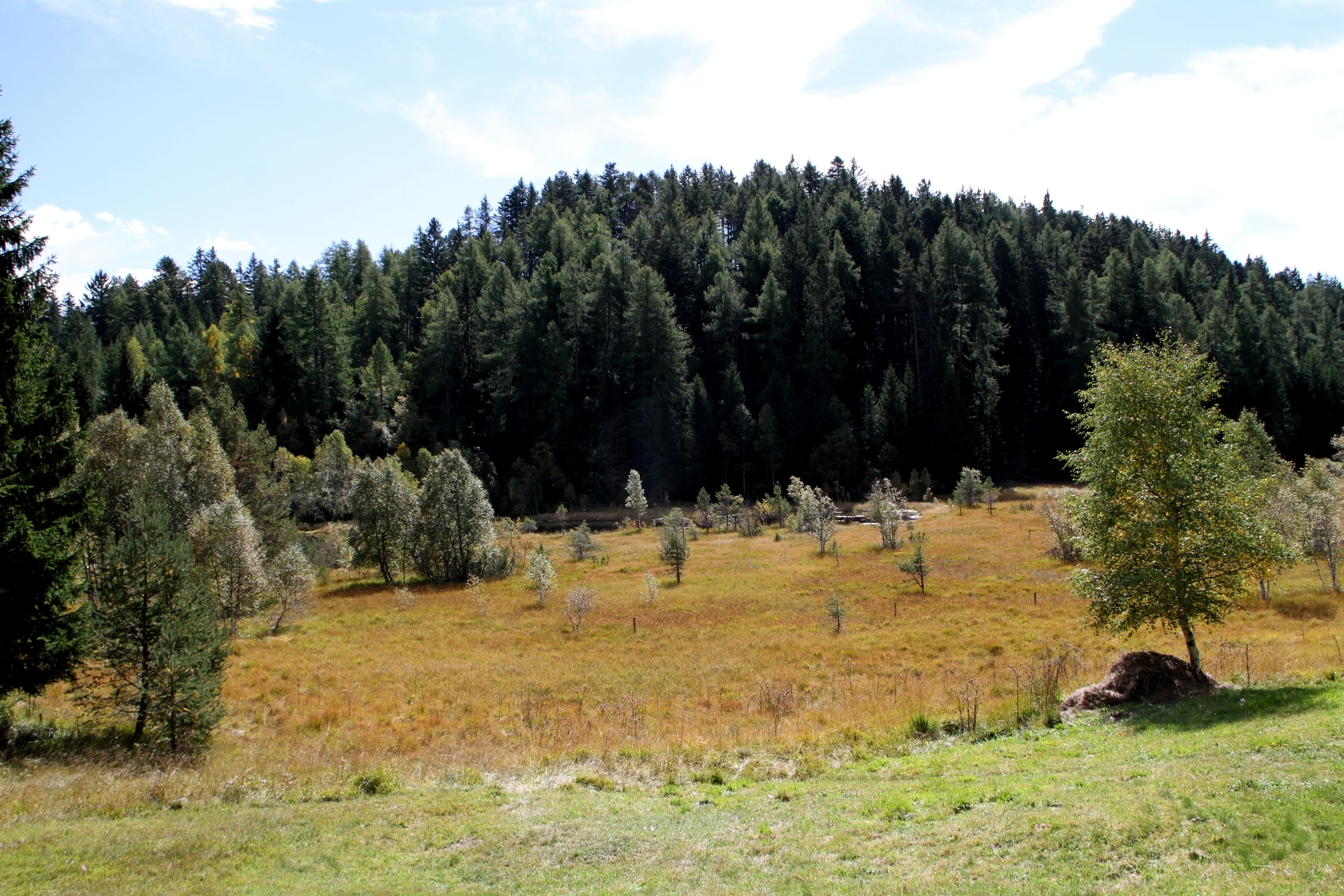
A wide view of a marshy peat bog landscape with golden grasses and scattered small trees, backed by a dense coniferous forest under a partly cloudy sky.
The marshland and surrounding forest at Biotopo Palù Longa.

Biotopo Palù Longa history and protected-area timeline

Protection of the Palù Longa area came in two stages. The portion of the site lying in South Tyrol, within the municipality of Anterivo, has been protected since 1980. The larger story of the site as a formal Italian biotopo, however, began in 1987, when the Autonomous Province of Trento established the biotope through a provincial decree.

Before that designation, the Trentino portion of the peatland was subject to peat extraction. This activity damaged the peatland complex, altering its hydrology and vegetation. The impact is documented especially clearly in the case of Rhynchospora alba, a rare peatland species recorded in a 1971 census, which has since disappeared from the site as a consequence of the extraction. The 1987 establishment of the biotope brought such damaging activity to a halt and formally committed the area to conservation management under the Province of Trento.

Biotopo Palù Longa landscape and geographic character

The biotope sits in a saddle on the watershed divide, or spartiacque, between the Cembra valley and the Fiemme valley. This relatively sheltered highland basin, surrounded by forested slopes, is the natural setting that allowed peat to accumulate over time. The site lies at a moderate elevation within the Alpine zone and contrasts with the steeper valley sides that descend toward Cembra to the west and Fiemme to the east.

Around the wetland itself, the landscape is dominated by spruce and larch forest, a typical subalpine forest type of the eastern Alps. Above and beyond these forests, the terrain opens into alpine meadows and pastures, reflecting the long-standing traditional land use of the area. The combination of open wetland, wooded margins, and pastureland creates a varied mosaic that climbs gently from the bog toward the surrounding ridges.

Biotopo Palù Longa ecosystems, habitats, and plant life

The ecological identity of Palù Longa is defined by its peatland vegetation and the highly specialized flora adapted to acidic, nutrient-poor peat soils. The plant communities include wet meadows, cariceti (sedge-dominated swards), open bog pools, Sphagnum mounds, and small wooded patches rich in Sphagnum mosses. These communities collectively support more than 120 recorded plant species.

The presence of Sphagnum is particularly important: Sphagnum mounds and Sphagnum-dominated microhabitats indicate an actively growing peat surface and are the kind of structures that harbor many of the rare peatland specialists documented at the site. The general wetness and acidic chemistry of the substrate make this one of the more ecologically distinctive small sites in the regional biotope network, despite its limited size of roughly 6 hectares.

Biotopo Palù Longa conservation status and protection priorities

Palù Longa is recognized as a protected natural area within the Italian official list of areas naturali protette (EUAP) and classified as a biotopo, a designation used in Trentino for small sites with focused conservation value. Its inclusion in this framework reflects the regional recognition of Alpine peatlands as habitat types requiring active protection because of their limited extent and high sensitivity to disturbance.

The site's conservation significance lies in its role as a refuge for peatland flora in a mountain landscape where such habitats are increasingly rare. Sphagnum communities and the specialized bog vegetation they support are particularly vulnerable to drainage and peat extraction, both of which historically affected this site. Its protected status aims to maintain the hydrological conditions required for Sphagnum growth and the persistence of the associated plant communities, including the carnivorous sundews that depend on these conditions.

Top sights and standout views in Biotopo Palù Longa

The biotope occupies a rare peatland habitat on an Alpine watershed divide, with more than 120 recorded plant species and two species of carnivorous sundews. It represents one of the small but ecologically important wetland fragments protected across the Trentino-Alto Adige region, illustrating how even very small sites can harbor specialized bog communities within a much larger forested mountain landscape.

Best time to visit Biotopo Palù Longa

The peatland vegetation of Palù Longa, including its wet meadows, sedges, and Sphagnum communities, is most visibly active during the warmer months, when the contrast between the green bog surface and surrounding larch and spruce forest is strongest. Late spring through early autumn offers the best conditions for observing the wetland in its growing state, while winter typically blankets the area in snow and reduces visible access. Because the site is protected for its conservation value rather than as a tourist attraction, visits are best approached as quiet, low-impact observation of a small Alpine wetland.
Monthly climate preview

Long-term representative coordinate measurements for monthly temperature and precipitation patterns

Biotopo Palù Longa Climate Normals, Annual Temperature and Precipitation Rhythm

Biotopo Palù Longa records measured long-term temperature swings and monthly precipitation values across the sampled representative elevation coordinate. Examining the complete twelve-month climatology profile clarifies the detailed seasonal weather distribution for this protected area.
Annual mean4 °C
-7 °C14 °C
Jan-7°
Feb-6°
Mar-1°
Apr
May
Jun12°
Jul14°
Aug14°
Sep
Oct
Nov-1°
Dec-6°
Warmest month
July

13.9 °C

Coolest month
January

-7.2 °C

Wettest month
August

3.7 mm/day

Driest month
January

1 mm/day

Park location guide

Geography guide, regional context, and park location map for Biotopo Palù Longa

Biotopo Palù Longa park geography, regions, and map view in Italy

Understand where Biotopo Palù Longa sits in Italy through a broader geographic reading of the surrounding landscape, nearby location context, and its mapped position within the national park landscape.

How Biotopo Palù Longa fits into Italy

Italy is a unitary parliamentary republic in Southern and Western Europe, located on the Italian Peninsula with the Alps to the north. It borders France, Switzerland, Austria, Slovenia, Vatican City, and San Marino, and shares maritime boundaries with several Mediterranean countries. The country has approximately 59 million residents and uses the Euro as its currency.

Wider geography shaping Biotopo Palù Longa in Italy

Italy occupies a boot-shaped peninsula in southern Europe, bordered by the Alps to the north. It shares land borders with France, Switzerland, Austria, Slovenia, Vatican City, and San Marino. The country includes the Mediterranean islands of Sicily and Sardinia, along with approximately 800 smaller islands.

Map view of Biotopo Palù Longa

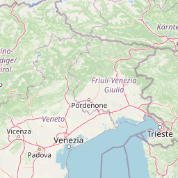
Use this park location map to pinpoint Biotopo Palù Longa in Italy, understand its exact geographic position, and read its mapped placement within the surrounding landscape more clearly.

Pigeon | © OpenStreetMap contributors

Location context for Biotopo Palù Longa

Trentino-Alto Adige

Visual reference for alpine peatland habitats and surrounding mountain forests

Biotopo Palù Longa Photos and Landscape Scenery

Explore detailed visual coverage of Biotopo Palù Longa to examine its rare wetland plant communities, Sphagnum bog pools, and surrounding spruce forests. Photographic documentation reveals the distinct terrain and protected landscape character found along this alpine watershed divide.

A wide view of a marshy peat bog landscape with golden grasses and scattered small trees, backed by a dense coniferous forest under a partly cloudy sky.

Park atlas

Compare adjacent wetland habitats and mountain reserves across the regional terrain

Explore Parks Near Biotopo Palù Longa and Surrounding Alpine Protected Areas

Browse other protected areas and mountain parks situated near Biotopo Palù Longa in the northern Italian Alps. Comparing adjacent wetland reserves and alpine valley landscapes provides broader context for regional conservation networks.
Nature reserveTrentino-Alto Adige
About 12 km away#1 closest

Southwest

Biotopo Prati di Monte: Nature Reserve and Protected Alpine Landscape Discovery

Geographic overview of the Dossone di Cembra alpine ridge

Biotopo Prati di Monte represents a protected nature reserve in Trentino-Alto Adige, known for its unique concentration of peatland habitats. The area encompasses the remnant Lago di Valda basin, acidic spruce forests, and diverse wetland meadows. This atlas-focused perspective highlights the reserve as a significant refugium for sub-arctic flora situated along the porphyritic mountain terrain between the Val di Cembra and the Bassa Atesina.

Area
0.06 km²
Established
1994
IUCN
IV
Watercolor illustration showing a mountainous landscape with a waterfall, green hills, and layered colors
National parkProvince of Belluno
About 38 km away#2 closest

East

Dolomiti Bellunesi National Park: National Park, Province of Belluno Protected Landscape

Explore mapped boundaries and regional geography

This entry details Dolomiti Bellunesi National Park, a distinct national park situated within the Province of Belluno. It provides essential geographic context and protected landscape information, enabling users to understand the park's boundaries and its role within the regional terrain. Dive into the mapped features and discover the atlas-driven details of this significant Italian protected area.

Area
32 km²
Established
1988
IUCN
II
Relief
Mountain
Nature reserveTrentino-Alto Adige
About 39 km away#3 closest

Southwest

Torbiera delle Viote Nature Reserve: Alpine Wetland Plateau Geography and Protected Boundaries

A high-elevation peat bog enclave within the Monte Bondone mountain landscape

Situated on the Piana delle Viote in the Trentino-Alto Adige region, this nature reserve protects a rare alpine peat bog ecosystem. The site functions as a unique wetland basin framed by dense conifer forests, offering significant insight into high-altitude hydrology, amphibian habitats, and the specific terrain features that define this protected mountain landscape.

Area
0.13 km²
Established
2003
A horizontal watercolor illustration depicting a lake framed by green rolling hills and distant purple mountain ridges.
Nature reserveTrentino-Alto Adige
About 41 km away#4 closest

Southwest

Biotopo Lago di Toblino Protected Area and Regional Landscape Geography

Nature reserve featuring Alpine and sub-Mediterranean plant habitats

Biotopo Lago di Toblino acts as a sheltered basin where lake, marsh, and woodland habitats create an essential corridor for wildlife. This protected landscape is shaped by the interplay between the surrounding steep mountains and the influence of nearby Lake Garda, fostering an unusual climatic overlap that supports a wide range of native flora and waterbird populations within an important European conservation site.

Area
1.705 km²
Established
1992
IUCN
IV
Watercolor painting of a mountain range with a lake, green hills, and a sunset sky
National parkTrentino-Alto Adige/Südtirol
About 43 km away#5 closest

West

Stelvio National Park National Park: Protected Landscape and Regional Geographic Context

Explore its mapped boundaries and natural terrain.

Navigate Stelvio National Park, a designated national park in Italy's Trentino-Alto Adige/Südtirol region, through a map-centric lens. This page provides critical context for understanding the park's protected landscape, its geographic position within the Alps, and its mapped terrain. Utilize MoriAtlas to grasp the park's boundaries and its place in regional geography for structured natural landscape discovery.

Established
1935
IUCN
II
Relief
Mountain
Scope
Terrestrial
Soft watercolor painting of layered green hills and distant mountain ranges with a hazy, light-filled sky.
Nature reserveTrentino-Alto Adige
About 48 km away#6 closest

Southwest

Biotopo Marocche di Dro: Geologic Protected Landscape in Trentino-Alto Adige

Discover the massive postglacial rockfall deposits of northern Italy.

Biotopo Marocche di Dro is a protected nature reserve defined by its expansive, boulder-strewn arid surface and exceptional postglacial rockslide deposits. Unlike typical wetland biotopes, this site provides a rare, sun-exposed habitat for reptile-rich fauna and unique plant communities within the broader Trentino landscape, offering a window into the dramatic geological transformations that have shaped the valley floor.

Area
2.508 km²
Established
1989
IUCN
IV
Nature reserveTrentino-Alto Adige
About 52 km away#7 closest

Southwest

Biotopo Lomasona Nature Reserve: Protected Landscapes and Alpine Geography in Trentino

A small-scale conservation area in the heart of Val Lomasona

Biotopo Lomasona stands as a specialized nature reserve in the Italian Province of Trento. This compact protected area focuses on habitat conservation within the alpine terrain, serving as an important ecological anchor in the valley landscape of Comano Terme and the wider Trentino-Alto Adige region.

Area
0.26 km²
Established
1987
IUCN
IV
A watercolor painting showing a panoramic view of a green wetland landscape with soft purple mountains in the background.
Nature reserveTrentino-Alto Adige
About 53 km away#8 closest

Southwest

Biotopo Fiavé: A Protected Wetland and Archaeological Landscape in Trentino-Alto Adige

Mapping glacial lake basins and ancient prehistoric heritage sites

Located at the foot of Monte Cogorna, Biotopo Fiavé functions as a vital wetland reserve characterized by extensive peat bogs and mixed willow-alder thickets. This area offers a unique intersection of natural hydrological evolution and UNESCO-protected archaeological history, serving as a rare, compact cross-section of alpine valley ecosystems and prehistoric human settlement patterns.

Area
1.373 km²
Established
1988
IUCN
IV

Common questions about visiting, size, designation, and location context for Biotopo Palù Longa

Biotopo Palù Longa FAQs for park facts, access, geography, and protected area context

Find quick answers about Biotopo Palù Longa, including protected-area facts, park geography, trail and visitor context, and how the park fits into its surrounding country and regional landscape.
MoriAtlas Explorer

Continue Your Protected Areas Search Across the Global Atlas

Deepen your exploration by continuing the structured search for national parks and protected areas worldwide. Utilize the comprehensive filtering capabilities to compare different conservation landscapes and refine your understanding of global park geography. Discover more about the distribution and characteristics of protected natural areas.

Global natural geography