Mori Atlas logo
Nature reserveBird Island Nature Reserve

Examining the geographic boundaries and marine protected terrain of this unique Western Cape nature reserve

Bird Island Nature Reserve: A Detailed Atlas of Protected Coastal Seabird Landscapes

Bird Island Nature Reserve is a compact yet ecologically vital coastal landscape situated just offshore from Lambert's Bay in South Africa. This protected area acts as a crucial breeding habitat for Cape gannets and crowned cormorants, with mapped terrain consisting of exposed rocky platforms shaped by centuries of seabird activity. Explore the geography and environmental context of this three hectare marine reserve located within the broader Western Cape coastal framework.

seabirdscape gannetcormorantsWest Coastisland reserveBenguela ecosystem

Bird Island Nature Reserve

Nature reserve

Park overview

Structured park overview, official facts, and landscape profile for Bird Island Nature Reserve

Bird Island Nature Reserve park facts, protected area profile, and essential visitor context

Review the core facts for Bird Island Nature Reserve, including designation, size, terrain, visitor scale, habitats, and operating context in one park-focused overview.

About Bird Island Nature Reserve

Bird Island Nature Reserve is a small, rocky island reserve situated immediately off the harbour of Lambert's Bay, a fishing town on South Africa's West Coast in the Western Cape province. Although the island itself spans only about three hectares, it carries an outsized ecological significance as one of the most important seabird breeding sites along the country's Atlantic seaboard. Its proximity to the mainland, combined with a dedicated viewing walkway, has made it a flagship destination for visitors who want to view large, active seabird colonies without traveling far offshore.

The reserve's identity is defined by birds rather than by dramatic landscape features. The island's flat rocky platforms and low cliffs provide ideal nesting terrain for colonial seabirds that require exposed marine sites close to productive feeding grounds. The cold, nutrient-rich Benguela Current that flows along this coast supports large populations of pelagic fish, which in turn sustain the seabirds that breed on the island. This combination of accessible nesting habitat and abundant nearby food makes the reserve a vital node in the regional seabird ecosystem.

Beyond its ecological function, Bird Island Nature Reserve has become an important public engagement site. Interpretive materials, viewing platforms, and guided experiences allow visitors to observe nesting behavior, chick-rearing, and the broader rhythms of a working seabird colony. In a region where marine wildlife often lies beyond easy view, the reserve offers an unusually direct encounter with southern African seabird life, making it valuable not only for conservation but also for environmental education and nature-based tourism in the Western Cape.

Quick facts and research context for Bird Island Nature Reserve

Bird Island Nature Reserve lies off the coast of Lambert's Bay in the Cederberg Local Municipality of the Western Cape, South Africa. The reserve covers just three hectares of rocky island terrain, making it a compact but intensely inhabited seabird site. It has been formally protected since 18 March 1988 and is governed by CapeNature, the public agency responsible for biodiversity conservation in the Western Cape.

The reserve functions as both a breeding sanctuary for seabirds and a managed ecotourism destination, accessed from the mainland via a short walkway. Its identity is shaped almost entirely by its birdlife, particularly its Cape gannet colony and the smaller crowned cormorant breeding groups, which together make the island one of the most well-known seabird viewing locations on the South African coast.

Protection and recognition

Examine documented protection scope and international recognition status

Bird Island Nature Reserve Protection Status and Governance

Bird Island Nature Reserve maintains a documented mixed protection scope alongside assigned governance frameworks. Official conservation records outline international recognition data and administrative boundaries for public exploration.

Protection details

Protection scope
Mixed
Transboundary protection
No
Park context

Deeper park guide and search-rich context for Bird Island Nature Reserve

Bird Island Nature Reserve history, landscape, wildlife, and travel context

Explore Bird Island Nature Reserve through its history, landscape character, ecosystems, wildlife, conservation priorities, cultural context, and seasonal travel timing in a structured park guide built for atlas discovery and search intent.

Why Bird Island Nature Reserve stands out

Bird Island Nature Reserve is most famous for its accessible Cape gannet breeding colony, one of only a handful of mainland-reachable gannet colonies in the world. Cape gannets nest in dense, noisy groups on the island's flat rocky surfaces, creating a vivid spectacle that has made the reserve a fixture of West Coast wildlife tourism. Equally central to the island's identity is its role as a breeding site for crowned cormorants, a coastal seabird whose regional populations have been pressured by human disturbance and habitat loss elsewhere. Together, the gannets and cormorants give Bird Island a tight, seabird-driven ecological profile that defines everything from its conservation role to its visitor appeal.
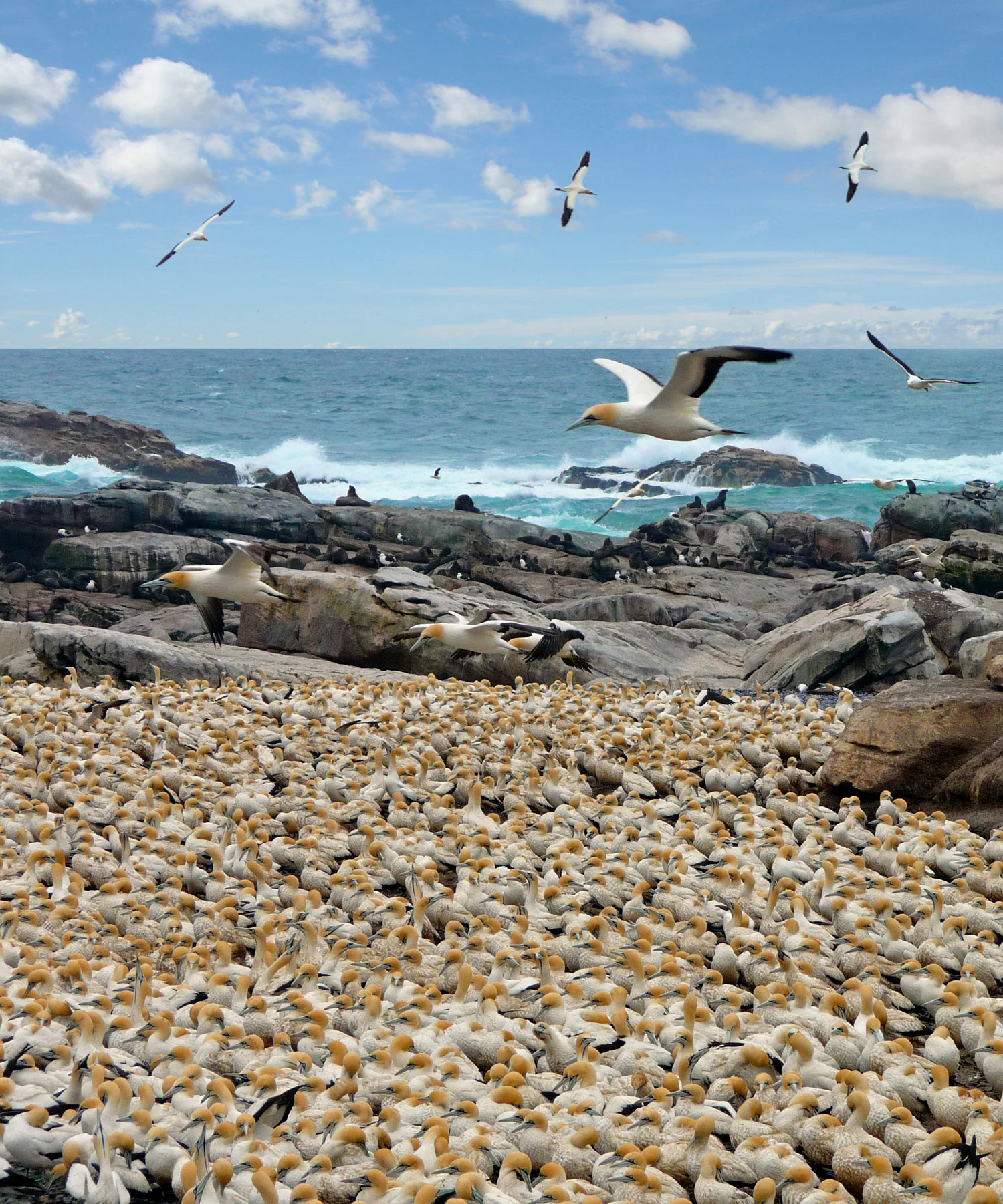
A dense colony of white and yellow-headed Cape gannets covers a rocky coastal area, with several birds flying above the rocky shore and the ocean in the background.
A large breeding colony of Cape gannets at Bird Island Nature Reserve.

Bird Island Nature Reserve history and protected-area timeline

Bird Island has a long human history that predates its formal conservation status. From 1888 until 1990, the guano deposits accumulated over decades of seabird activity were harvested commercially from the island, with the material used as a high-value natural fertilizer. This long period of guano collection significantly altered the surface character of the island and reflected an era when seabird islands were valued primarily as extractive resources rather than as protected habitats.

The shift toward conservation came on 18 March 1988, when the island was officially proclaimed as the Lambert's Bay Penguin Island Provincial Nature Reserve, formally recognizing its ecological importance and placing its birdlife under legal protection. Guano harvesting continued for a short time after proclamation but was eventually phased out, ending in 1990. Since then, the island has been managed primarily for seabird conservation, public education, and ecotourism rather than for resource extraction.

Today, under the stewardship of CapeNature, the reserve represents a transition from a harvested guano island to a protected seabird sanctuary, and its history is quietly visible in the altered surfaces and continuing recovery of the breeding habitat. The reserve's story reflects a broader pattern along the South African coast, where small offshore islands have moved from exploitation toward protection and public appreciation.

Bird Island Nature Reserve landscape and geographic character

The landscape of Bird Island Nature Reserve is defined by its small size, its exposed coastal position, and the cumulative effect of centuries of seabird activity. The island consists largely of flat and gently sloping rocky surfaces, low rocky shelves, and small outcrops that have been shaped by wind, salt spray, and bird use. There is no tall vegetation, freshwater, or significant soil cover; the terrain reads as a worked, sun-bleached rocky platform rising just above the surrounding Atlantic waters.

What little surface relief the island has plays an outsized ecological role, because subtle changes in rock height and exposure determine which species can nest where. Gannets favor the more open, sun-exposed plateaus where they can launch into flight easily, while cormorants and other species often use lower ledges and crevices closer to the waterline. The resulting mosaic of nesting zones is itself a kind of living landscape, shaped each breeding season by the colonies that occupy it.

The broader setting adds depth to the island's character. Lambert's Bay itself is a working fishing harbor, and the reserve sits within a human coastal landscape of boats, jetties, and small waterfront infrastructure. The juxtaposition of this compact, intensely inhabited seabird island against the backdrop of the Atlantic coast and a busy harbor town makes the reserve's landscape feel both intimate and clearly coastal.
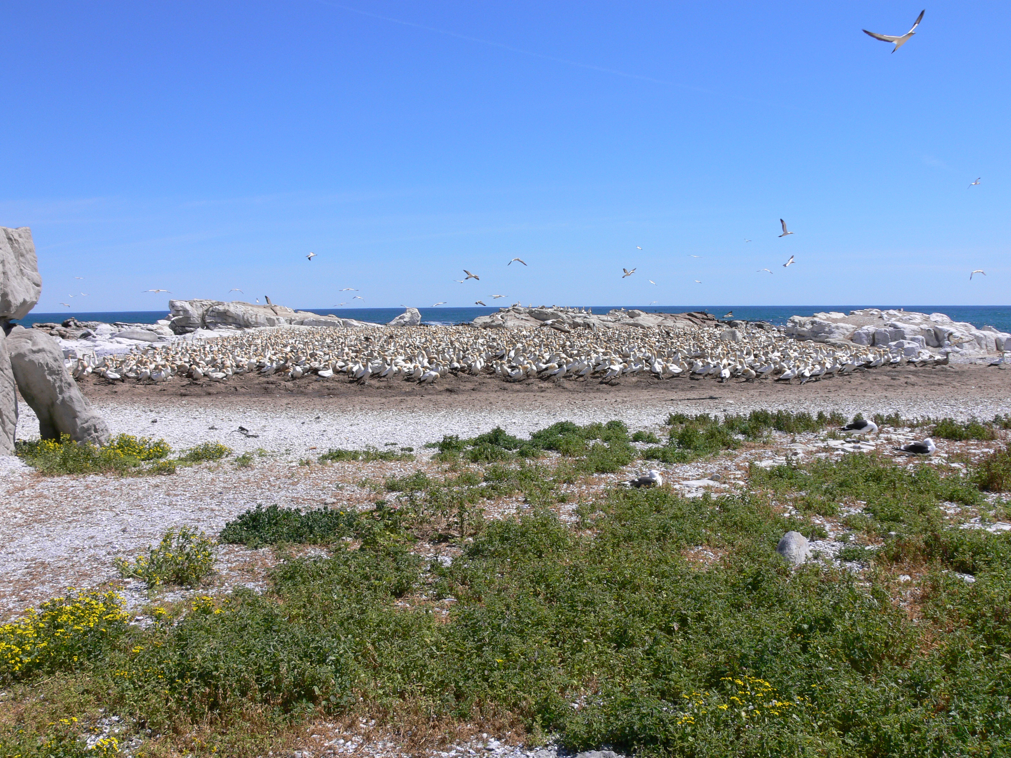
A wide view of a dense nesting colony of white seabirds on a rocky island, with ocean in the background and sparse vegetation in the foreground.
A large colony of Cape gannets breeding on Bird Island.

Bird Island Nature Reserve ecosystems, habitats, and plant life

Ecologically, Bird Island Nature Reserve is a focused seabird habitat, not a mixed terrestrial ecosystem. The island's nature is structured around colonial breeding seabirds, marine-driven nutrient cycling, and the influence of the cold Benguela Current ecosystem offshore. There is virtually no terrestrial plant cover; instead, the biological character of the island is set by guano, feathers, nesting material, and the constant turnover of an active breeding colony.

The surrounding waters are as important as the island itself. The Benguela Current supports high primary productivity and large stocks of small pelagic fish, which in turn supply the food base for the seabirds breeding on the island. Because the colony is small and spatially concentrated, even modest changes in offshore food availability can have visible effects on breeding success, chick survival, and seasonal attendance at the colony.

Within this tight ecological frame, biodiversity is expressed through behavior and seasonal rhythm rather than through habitat variety. The reserve's natural value lies in its role as a functioning breeding node in a much larger marine ecosystem, a place where the dynamics of the Benguela are translated, in real time, into noise, movement, and visible life on a small patch of rock.

Bird Island Nature Reserve wildlife and species highlights

The wildlife of Bird Island Nature Reserve is dominated almost entirely by seabirds. The Cape gannet is the most numerous and conspicuous species, breeding on the island's exposed rocky slopes and plateaus in dense colonies characterized by constant vocalizations, paired displays, and visibly defended nest sites. Gannets are large, powerful plunge-divers, and their presence gives the island its most recognizable sensory identity, combining visual density with the heavier smell of an active guano-rich colony.

Crowned cormorants form the second key breeding group on the island. These darker, more localized coastal cormorants nest in smaller clusters on lower rocks and ledges, often close to the water's edge. Their presence is significant because crowned cormorants have a limited breeding range along the southern African coast and have been affected in other areas by disturbance and habitat change, making protected sites like Bird Island particularly important.

Other seabirds and occasional visitors supplement the island's birdlife, including gull species, other cormorant and shag relatives that may roost on the rocks, and various species passing through offshore. Marine life immediately around the island includes the fish stocks and occasional marine mammals, seabirds, and other near-shore fauna typical of the Benguela-driven West Coast. The overall impression is one of a concentrated, bird-rich environment rather than a diverse multi-habitat assemblage.

Bird Island Nature Reserve conservation status and protection priorities

From a conservation standpoint, Bird Island Nature Reserve is significant because it protects breeding habitat for seabird species that depend on a small number of safe nesting sites along the southern African coast. Cape gannets, in particular, breed at only a handful of mainland and offshore colonies, and the protection of each site is disproportionate to its size. By safeguarding one of these colonies from direct human disturbance and habitat degradation, the reserve contributes to the long-term viability of the species in the region.

The reserve also has conservation value as a guano-impacted island in recovery. After more than a century of extraction, the cessation of guano harvesting in 1990 allowed nesting conditions to stabilize, and ongoing management focuses on maintaining conditions suitable for breeding rather than on resource extraction. This shift mirrors broader South African policy moves away from exploiting offshore islands for their mineral deposits.

CapeNature's stewardship of the reserve reflects an integrated conservation approach that combines habitat protection, public access, and education. By allowing carefully managed visitor access to a working seabird colony, the reserve builds public support for marine and coastal conservation, while simultaneously ensuring that the breeding birds remain protected from the kind of unregulated disturbance that has affected seabird colonies elsewhere in the world.

Bird Island Nature Reserve cultural meaning and human context

Lambert's Bay has a long regional identity as a West Coast fishing community, and Bird Island sits at the intersection of that working maritime culture and modern wildlife tourism. The island's early role as a guano source connected it to the broader extractive economy of the South African coast in the late nineteenth and twentieth centuries, a period when seabird islands were valued for the fertilizer their accumulated droppings produced.

Local heritage today is more closely tied to the reserve's role as a visitor attraction. The island has become a defining coastal landmark for Lambert's Bay, referenced in regional tourism, school excursions, and visitor literature about the West Coast. In this sense, the reserve has shifted from being an industrial outpost to becoming a cultural symbol of the town's relationship with the sea, supporting local livelihoods through ecotourism while preserving a distinctive piece of the regional coastal identity.

Top sights and standout views in Bird Island Nature Reserve

Among the reserve's strongest points of distinction are its accessible Cape gannet breeding colony, its compact crowned cormorant nesting population, and the unusual proximity of a fully active seabird colony to a working mainland harbor. These qualities make Bird Island a place where the visitor experience and the ecological reality are unusually close, with birds visible at ranges that would be impossible at most other colonies.

The reserve is also notable for its compact size and focused mission. At just three hectares, it does not attempt to represent a broad ecosystem; instead, it concentrates on protecting a precisely defined slice of seabird habitat, and in doing so offers an unusually clear example of how a very small protected area can carry significant conservation weight within a much larger marine system.

Best time to visit Bird Island Nature Reserve

The character of a visit to Bird Island Nature Reserve shifts with the breeding cycle of its seabirds rather than with conventional tourist seasons. Cape gannets are present on the island for much of the year, but the density of breeding activity, visible chick-rearing, and peak colony noise typically align with the warmer months along the West Coast, when conditions for nesting are most favorable and the spectacle of the colony is at its fullest.

Visitors in cooler months will find a quieter, less crowded experience, but breeding intensity and visible activity may be reduced, depending on the timing within the annual cycle. Because the reserve's appeal is so closely tied to seabird behavior, planning around the breeding season tends to produce a more rewarding visit than planning around general weather windows alone.
Monthly climate preview

Long-term representative monthly temperature and precipitation data patterns

Bird Island Nature Reserve Climate Normals and Annual Temperature Rhythm

Historical data records a measured annual cycle of monthly temperature and precipitation normals at a representative point within Bird Island Nature Reserve. Detailed month-by-month values provide deeper insight into the long-term meteorological rhythm defining the local habitat.
Annual mean17 °C
13 °C20 °C
Jan20°
Feb20°
Mar19°
Apr17°
May16°
Jun14°
Jul13°
Aug14°
Sep15°
Oct16°
Nov18°
Dec19°
Warmest month
February

19.8 °C

Coolest month
July

13.4 °C

Wettest month
June

1.6 mm/day

Driest month
February

0.2 mm/day

Park location guide

Geography guide, regional context, and park location map for Bird Island Nature Reserve

Bird Island Nature Reserve park geography, regions, and map view in South Africa

Understand where Bird Island Nature Reserve sits in South Africa through a broader geographic reading of the surrounding landscape, nearby location context, and its mapped position within the national park landscape.

How Bird Island Nature Reserve fits into South Africa

South Africa is the southernmost country in Africa, spanning 1.22 million km² with a population of over 63 million. The country operates with three capital cities, Pretoria (executive), Cape Town (legislative), and Bloemfontein (judicial), and is renowned for its biodiversity, national parks, and multicultural society.

Wider geography shaping Bird Island Nature Reserve in South Africa

South Africa occupies the southernmost region of Africa, with coastline along both the Atlantic Ocean to the west and the Indian Ocean to the east. The interior features elevated plateaus including the Highveld, with the Drakensberg escarpment marking the eastern highlands. The country shares borders with Namibia, Botswana, Zimbabwe, Mozambique, Eswatini, and Lesotho.

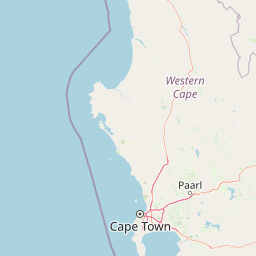
Map view of Bird Island Nature Reserve

Use this park location map to pinpoint Bird Island Nature Reserve in South Africa, understand its exact geographic position, and read its mapped placement within the surrounding landscape more clearly.

Pigeon | © OpenStreetMap contributors

Location context for Bird Island Nature Reserve

Western Cape

Visual reference of breeding seabird colonies and coastal terrain in South Africa

Bird Island Nature Reserve Photos and Coastal Landscape Scenery

Visual documentation captures the exposed rocky terrain, flat nesting plateaus, and marine surroundings that define Bird Island Nature Reserve. Examining these coastal landscapes reveals how fragile seabird colonies and specialized breeding habitats occupy a compact marine sanctuary.

A dense colony of white and yellow-headed Cape gannets covers a rocky coastal area, with several birds flying above the rocky shore and the ocean in the background.

A rock-like concrete structure used as a bird observation hide with a small viewing platform on top, positioned near a coastal colony of white seabirds.

A wide view of a dense nesting colony of white seabirds on a rocky island, with ocean in the background and sparse vegetation in the foreground.

Park atlas

Compare coastal reserves and regional protected landscapes across the West Coast

Parks Near Bird Island Nature Reserve And Surrounding Protected Areas

Browse other parks near Bird Island Nature Reserve to evaluate surrounding coastal habitats and regional marine conservation areas. Comparing these protected landscapes provides broader geographic context for South Africa and adjacent wildlife reserves.
Nature reserveWestern Cape
About 58 km away#1 closest

South

Rocherpan Nature Reserve: Mapping Coastal Wetlands and Strandveld Landscapes in the Western Cape

Protected coastal reserve on the South African West Coast.

Located along the Atlantic shore between Velddrif and Elands Bay, Rocherpan Nature Reserve encompasses a rare, seasonal wetland system. The reserve protects a complex of dune cordons, sandy beaches, and low-lying coastal veld that transforms dramatically with the winter rains. This map-focused entry highlights the ecological layering and geographic significance of this South African protected area.

Area
18 km²
Established
1976
Relief
Lowland
Climate
Mediterranean
A watercolor illustration of a scenic wilderness landscape with rolling hills, a winding stream, foreground grasses, and a distinct rock arch formation in the background.
Wildlife reserveWestern Cape
About 78 km away#2 closest

East

Cederberg Wilderness Area: Geographic Overview of Western Cape Protected Landscapes

Mapped sandstone peaks and diverse fynbos wilderness.

The Cederberg Wilderness Area represents a rugged mountain range defined by its resistant Peninsula Formation sandstone and complex geological history. Encompassing dramatic rock formations, ancient caves, and unique botanical endemics, the area offers a study in the intersection of mountainous terrain and the Cape Floral Region. Understand the regional context and physical geography that shape this protected sanctuary.

Area
710 km²
Established
1973
Relief
Mountain
Climate
Mediterranean
A stylized digital illustration of a deep gorge with steep rocky cliffs, a flowing river, a waterfall, and trees in the foreground.
Nature reserveNorthern Cape
About 97 km away#3 closest

Northeast

Oorlogskloof Nature Reserve; Protected Mountain Landscapes and River Gorges of Northern Cape

A diverse protected area featuring Karoo-fynbos biome transitions.

Oorlogskloof Nature Reserve presents a dramatic study in regional geography, characterized by deep river canyons, exposed rock shelves, and vast semi-desert plateaus. Located near the edge of the Knersvlakte, the reserve creates a refuge where seasonal waterfalls and rocky basins provide essential freshwater habitats. This atlas entry focuses on the interplay between its steep cliff formations and the surrounding Northern Cape plains, offering a comprehensive view of the terrain and ecological diversity.

Area
47.76 km²
Established
1971
Relief
Mountain
Scope
Terrestrial
National parkWestern Cape
About 108 km away#4 closest

South

West Coast National Park: A National Park's Mapped Boundaries and Geographic Identity

Explore its protected landscape within the Western Cape region.

West Coast National Park is a protected national park situated in the Western Cape province of South Africa. This dedicated page provides a structured view of its geographic scope, emphasizing its mapped boundaries and its significance as a protected landscape within the region's broader atlas context. Gain insight into the park's distinct natural terrain and regional geography.

Area
362.59 km²
Established
1985
Climate
Mediterranean
Access
Easy access
Nature reserveWestern Cape
About 112 km away#5 closest

Southeast

Matjiesrivier Nature Reserve: Botanical Diversity and San Rock Art in Western Cape

A protected landscape bridging fynbos and karoo ecosystems

Matjiesrivier Nature Reserve represents a critical conservation landscape in South Africa, known for the transition between mountain terrain and semi-arid basins. The reserve protects unique slate-based soil habitats that sustain a blend of Cape Floral Kingdom vegetation and hardy karoo species. Visitors and researchers recognize this area for its high density of San rock art sites, offering a deep cultural look into the Late Stone Age history of the Western Cape.

Area
128 km²
Established
1995
Water
Minor water
A horizontal watercolor painting showing a soft, stylized mountain landscape with green hills, purple shadows, and grassy foreground.
Wildlife reserveWestern Cape
About 129 km away#6 closest

Southeast

Groot Winterhoek Wilderness Area: Protected Mountain Reserve in the Western Cape

Mapping sandstone ridges, fynbos plateaus, and mountain river systems

Spanning 30,000 hectares, Groot Winterhoek Wilderness Area represents a core mountain wilderness in South Africa. Its dissected landscape of Table Mountain sandstone features high peaks, sheltered kloofs, and seasonal rockpools, forming a critical ecological corridor and water catchment within the Cape Fold Belt mountain system.

Area
306.08 km²
Relief
Mountain
Climate
Mediterranean
Access
Moderate access
Watercolor illustration showing a mountain range with green hills and pink flowers
National parkNorthern Cape
About 130 km away#7 closest

East

Tankwa Karoo National Park National Park: Mapped Protected Landscape in Northern Cape

Explore regional geography and protected area boundaries.

Tankwa Karoo National Park is a key protected area situated in the vast Northern Cape region of South Africa. This entry provides a detailed atlas perspective, focusing on the park's mapped geography and its significance as a national park. Understand the park's landscape context and its position within the broader regional geography for informed exploration and geographic discovery.

Area
1,436 km²
Established
1986
Relief
Upland
Climate
Arid
A watercolor painting showing a soft, panoramic landscape with green hills in the background, a body of water in the middle ground, and grasses in the foreground.
Nature reserveWestern Cape
About 148 km away#8 closest

South

Dassen Island Nature Reserve: Atlantic Geography and Protected Area Overview

Coastal refuge and protected granite-based Atlantic island

Located in the cold waters off the Western Cape, Dassen Island is a proclaimed nature reserve and Ramsar wetland. This flat Atlantic landmass is characterized by its granitic reef structure and long-established role as a sanctuary for African penguins and other seabird populations. The island represents a convergence of maritime history and marine conservation, offering a unique geographic perspective on South Africa's coastal wilderness.

Area
2.6 km²
Established
2019
Relief
Lowland
Climate
Mediterranean

Common questions about visiting, size, designation, and location context for Bird Island Nature Reserve

Bird Island Nature Reserve FAQs for park facts, access, geography, and protected area context

Find quick answers about Bird Island Nature Reserve, including protected-area facts, park geography, trail and visitor context, and how the park fits into its surrounding country and regional landscape.
MoriAtlas Explorer

Continue Your Protected Areas Search Across the Global Atlas

Deepen your exploration by continuing the structured search for national parks and protected areas worldwide. Utilize the comprehensive filtering capabilities to compare different conservation landscapes and refine your understanding of global park geography. Discover more about the distribution and characteristics of protected natural areas.

Global natural geography