

Mori Atlas logo
Wildlife reserveBobiri Forest Reserve and Butterfly Sanctuary

Tracing the forest boundaries and semi-deciduous terrain of West Africa's primary butterfly sanctuary

Bobiri Forest Reserve and Butterfly Sanctuary: Mapped Protected Landscapes in the Ashanti Region

Bobiri Forest Reserve and Butterfly Sanctuary serves as a vital protected landscape within the Ashanti Region of Ghana. Established to conserve approximately 54 square kilometers of semi-deciduous tropical forest, this wildlife reserve provides an essential habitat for nearly 400 butterfly species. The sanctuary functions as a crucial research site and an accessible corridor for observing forest ecology amidst the surrounding mosaic of agricultural land.

butterfly sanctuarytropical forestsemi-deciduous forestecotourismresearch reserveWest Africa

Bobiri Forest Reserve and Butterfly Sanctuary

Wildlife reserve

Park overview

Structured park overview, official facts, and landscape profile for Bobiri Forest Reserve and Butterfly Sanctuary

Bobiri Forest Reserve and Butterfly Sanctuary park facts, protected area profile, and essential visitor context

Review the core facts for Bobiri Forest Reserve and Butterfly Sanctuary, including designation, size, terrain, visitor scale, habitats, and operating context in one park-focused overview.

About Bobiri Forest Reserve and Butterfly Sanctuary

Bobiri Forest Reserve and Butterfly Sanctuary is a protected forest landscape in central Ghana that bridges ecological research, biodiversity conservation, and nature-based tourism. Although its name emphasizes butterflies, the reserve is fundamentally a piece of the larger semi-deciduous forest ecosystem that once covered much of the Ashanti Region, and its value lies as much in its standing forest and surrounding communities as in its charismatic Lepidoptera.

The sanctuary sits on the main Accra to Kumasi highway, between the regional capital Kumasi and the wider road network that links southern and northern Ghana. This roadside position is unusual for an ecological reserve of its size and contributes to its role as a teaching, research, and visitor site. Within about half an hour's drive of KNUST, one of Ghana's principal scientific universities, Bobiri is frequently used for fieldwork, environmental education, and biodiversity studies, which reinforces its identity as a living research reserve rather than a purely scenic park.

Ecologically, Bobiri represents the kind of moist semi-deciduous forest that characterizes the wetter parts of the Ashanti Region. Its mosaic of closed canopy, gaps, and edges supports a rich invertebrate community, with butterflies serving as the most visible indicator of broader forest health. The forest also harbors birds, mammals, reptiles, and plant communities typical of Ghanaian high forest, giving the reserve an importance that extends well beyond its flagship butterflies.

The reserve is encircled by six communities: Krofrom, Kubease, Ndobom, Koforidua, Nkwankwaduam, and Tsteteseakasum. This surrounding human presence makes Bobiri both a conservation area and a shared landscape, and many of the everyday questions of its management revolve around how forest, wildlife, and local livelihoods coexist at this boundary. As an ecotourism destination, the sanctuary offers visitors a chance to walk through a relatively intact West African forest and encounter one of its most diverse insect groups in the wild.

Quick facts and research context for Bobiri Forest Reserve and Butterfly Sanctuary

Bobiri Forest Reserve and Butterfly Sanctuary is located in the Ashanti Region of Ghana, near the town of Kubease along the Accra to Kumasi highway. It was gazetted in 1939, making it one of Ghana's older forest reserves, and it covers approximately 54.65 square kilometers of semi-deciduous forest.

The reserve is the only butterfly sanctuary in West Africa and is known for an exceptionally high count of butterfly species, estimated at around 400. It operates simultaneously as a nature reserve, a research site, and an ecotourism destination, and it is bordered by six villages whose presence is central to its landscape and governance context.

Protection and recognition

Terrestrial protected area conservation records and management scope details

Bobiri Forest Reserve and Butterfly Sanctuary Protection Status and Designation Facts

Bobiri Forest Reserve and Butterfly Sanctuary maintains documented terrestrial protection status within a managed natural landscape. Official records outline the conservation scope and designation context for geographic analysis.

Protection details

Protection scope
Terrestrial
Transboundary protection
No
Park context

Deeper park guide and search-rich context for Bobiri Forest Reserve and Butterfly Sanctuary

Bobiri Forest Reserve and Butterfly Sanctuary history, landscape, wildlife, and travel context

Explore Bobiri Forest Reserve and Butterfly Sanctuary through its history, landscape character, ecosystems, wildlife, conservation priorities, cultural context, and seasonal travel timing in a structured park guide built for atlas discovery and search intent.

Why Bobiri Forest Reserve and Butterfly Sanctuary stands out

Bobiri is best known as the only dedicated butterfly sanctuary in West Africa and as one of the most butterfly-rich protected forests in Ghana. Its approximately 400 recorded species place it among the most important sites in the region for studying and observing tropical butterflies in a wild, forested setting rather than in captive display. The sanctuary's reputation also rests on its accessibility. Its position on the major Accra to Kumasi road, close to Kumasi and the university community around KNUST, makes it a rare combination of a relatively intact semi-deciduous forest reserve and a convenient field destination for researchers, students, and ecotourists.

Bobiri Forest Reserve and Butterfly Sanctuary history and protected-area timeline

Bobiri Forest Reserve was established in 1939 under the colonial forest administration of what was then the Gold Coast. Its early designation as a forest reserve placed it within the broader system of timber and watershed protections that the colonial government imposed across the Ashanti Region during the early twentieth century, when large stretches of high forest were being logged or converted to cocoa farming.

Over time, Bobiri's role expanded beyond timber protection. The forest gained recognition for its exceptionally high butterfly diversity, and this ecological signature became central to its identity. In addition to its conservation status, the reserve was developed as a research site, drawing biologists and students interested in Lepidoptera and broader forest ecology. Its proximity to Kumasi and to KNUST supported this research-oriented identity.

More recently, Bobiri has been promoted as an ecotourism destination, with the butterfly sanctuary framing attracting visitors who want to experience Ghanaian high forest without traveling to more remote national parks. Today, the reserve stands at the intersection of its 1939 origins as a regulated forest, its mid- and late-twentieth-century growth as a research site, and its contemporary role as a flagship forest-based tourist attraction in Ghana.

Bobiri Forest Reserve and Butterfly Sanctuary landscape and geographic character

The landscape of Bobiri is shaped by the moist semi-deciduous forest that historically dominated much of central Ghana. The terrain is generally rolling rather than mountainous, with forest covering the slopes and valleys in a relatively continuous canopy. Within this forested matrix, small streams and seasonal watercourses cut through the reserve, adding structural variety to the forest floor and supporting moisture-loving plants along their banks.

Because the reserve lies within a region shaped by cocoa farming and shifting cultivation, its surviving forest stands out as an unusually intact block of high forest in a landscape where most original cover has been fragmented. Visitors moving from the surrounding farmland and villages into Bobiri encounter an immediate shift into closed canopy, with the characteristic dim, green interior of mature West African semi-deciduous forest. Edge habitats, where forest meets farmland, are important transition zones where many of the butterflies and other invertebrates are especially visible.

The sanctuary's position, on the major Accra to Kumasi highway near Kubease, also defines how visitors experience it. The road provides relatively easy access, and the surrounding farmland and villages create a patchwork mosaic of cultivation, settlement, and secondary growth around the older core forest. This combination of intact interior forest and a frequented external corridor is part of what makes Bobiri both a working landscape and a place to view wildlife.

Bobiri Forest Reserve and Butterfly Sanctuary ecosystems, habitats, and plant life

Bobiri's ecological character is defined by moist semi-deciduous tropical forest, a vegetation type known for shedding part of its leaves in the dry season while retaining a significant evergreen component. This forest type supports complex vertical structure, with emergent trees rising above a closed canopy, a middle layer of subcanopy trees and lianas, and a shaded understory rich in saplings, herbs, and leaf litter. The result is a habitat mosaic that is exceptionally favorable for insects, ground-dwelling invertebrates, and the birds and mammals that depend on insects.

Seasonality plays a strong role in the ecology of the reserve. During the wetter months, the forest is lush and green, fruiting trees attract wildlife, and butterfly activity reaches high levels across a wide range of species. In the drier season, the canopy thins visually as deciduous trees drop leaves, increasing light penetration to the forest floor and producing floristic shifts that in turn influence where butterflies, birds, and mammals are most easily observed.

The reserve's ecological value extends well beyond butterflies. The same forests that host rich Lepidoptera communities also support varied birdlife, primates and other mammals, reptiles, amphibians, and a wide range of plants, including timber species and non-timber forest products important to surrounding communities. As a relatively continuous block of high forest in an otherwise heavily modified landscape, Bobiri also performs broader landscape functions such as watershed protection and refugia for forest-dependent species that have been lost from surrounding areas.

Bobiri Forest Reserve and Butterfly Sanctuary wildlife and species highlights

The wildlife profile of Bobiri is dominated, by reputation, by its butterflies. With about 400 recorded species, the reserve represents one of the most butterfly-rich sites known in Ghana, and the wide range of color patterns and behaviors among these species is a major reason visitors come to the sanctuary. Butterflies here are part of the broader forest web rather than a separate curiosity, and their diversity is widely taken as an indicator of the relative health of the wider forest ecosystem.

Beyond butterflies, the forest supports the typical fauna of Ghanaian high forest. Birds are a major component of the reserve's wildlife, with forest-dependent species using both the interior canopy and the edge habitats where the forest meets surrounding farmland. Mammals characteristic of this kind of semi-deciduous forest, including various primates and smaller forest mammals, are present in the reserve, though their visibility depends on the degree of disturbance and the timing of visits.

Reptiles and amphibians also form part of the reserve's fauna, finding habitat in streams, damp forest floor, fallen logs, and leaf litter. These groups are less conspicuous than butterflies and birds but contribute to the overall richness of Bobiri's wildlife and to its value for ecological research.

Bobiri Forest Reserve and Butterfly Sanctuary conservation status and protection priorities

The conservation significance of Bobiri lies in its combination of age, intactness, and research focus. Gazetted in 1939, the reserve has had more than eight decades of formal protection, which has helped it retain a level of forest cover that contrasts with the heavily converted surrounding landscape. In an era when much of Ghana's high forest has been reduced to fragments, Bobiri stands out as a relatively continuous block of semi-deciduous forest capable of sustaining populations of species that cannot survive in smaller patches.

As a research reserve, Bobiri has played an important role in scientific understanding of West African forest biodiversity. The unusually high butterfly count is itself a conservation-relevant finding, because butterflies serve as indicators of habitat quality and are easier to survey than many other groups. Research conducted at Bobiri contributes to broader knowledge of how Ghanaian forests function and how they should be managed.

Its role as the only butterfly sanctuary in West Africa also gives the reserve a particular conservation identity. This designation draws attention to invertebrate conservation, a theme that is often underrepresented in protected-area discussion, and it positions Bobiri as a model for how charismatic insect groups can be used to anchor both tourism and long-term ecological monitoring in tropical forest settings.

Bobiri Forest Reserve and Butterfly Sanctuary cultural meaning and human context

Bobiri is embedded in a rural Ashanti landscape in which the forest has long had economic and cultural importance. The six communities surrounding the reserve: Krofrom, Kubease, Ndobom, Koforidua, Nkwankwaduam, and Tsteteseakasum: have historic ties to the forest through farming, hunting, collection of non-timber forest products, and in some cases small-scale timber use. The reserve's boundary is therefore a meeting place between regulated conservation and everyday rural life.

In the broader Ghanaian context, forests like Bobiri are part of the cultural geography of the Ashanti Region, where high forest, cocoa farming, and village settlements have long been interwoven. The reserve's transformation from a colonial-era timber reserve into a contemporary butterfly sanctuary and ecotourism site reflects evolving national priorities around conservation, scientific research, and nature-based tourism, while still requiring negotiation with the communities that live around its borders.

Education and research form another strand of Bobiri's cultural role. Its proximity to Kumasi and KNUST has made it a regular destination for university field exercises, ecological training, and citizen-science engagement, giving the reserve a meaningful place in the training of new generations of Ghanaian ecologists and conservation professionals.

Top sights and standout views in Bobiri Forest Reserve and Butterfly Sanctuary

A defining strength of Bobiri is its status as the only butterfly sanctuary in West Africa, hosting roughly 400 butterfly species in a protected forest setting. This makes it a standout destination for insect-focused ecotourism and for visitors interested in tropical Lepidoptera in their natural habitat rather than in butterfly houses.

The reserve's combination of formal protection since 1939, its research role tied to a major regional university, and its accessibility along the Accra to Kumasi highway makes it unusually versatile. It functions at once as a forest reserve, a research site, and a visitor destination, while still being framed by six surrounding communities that are central to its long-term management. For travelers interested in Ghanaian forest ecology, Bobiri offers a compact and informative window into the semi-deciduous forests of the Ashanti Region.

Best time to visit Bobiri Forest Reserve and Butterfly Sanctuary

Timing a visit to Bobiri is strongly shaped by rainfall. The wetter months, roughly corresponding to the main rainy season in the Ashanti Region, bring lush green forest conditions, active fruiting, and peak butterfly activity across many species. This period tends to reward visitors interested in observing butterflies and other invertebrates at their most active, as well as those drawn to the full visual richness of semi-deciduous forest in growth.

The drier months offer a different but equally valid experience. The canopy thins as deciduous trees drop leaves, increasing light on the forest floor and making it easier to see structure, flowers, and animals along trails and at the forest edges. Butterfly numbers may decrease compared to the rainy peak, but bird activity and visibility of forest architecture often improve. Choosing between seasons depends on whether a visitor prioritizes butterfly encounters and lush conditions or clearer viewing of forest structure and birdlife.

Monthly climate preview

Long-term representative point measurements of annual temperature and precipitation cycles

Bobiri Forest Reserve and Butterfly Sanctuary Climate Normals and Weather by Month

Representative coordinate records show measured monthly temperature averages alongside precipitation totals across the seasonal cycle at Bobiri Forest Reserve and Butterfly Sanctuary. Examining the complete twelve-month climatology profile provides deeper analytical context for long-term regional weather patterns.
Annual mean26 °C
24 °C28 °C
Jan27°
Feb28°
Mar28°
Apr27°
May26°
Jun25°
Jul24°
Aug24°
Sep25°
Oct25°
Nov26°
Dec26°
Warmest month
February

28.1 °C

Coolest month
July

24.2 °C

Wettest month
June

7.1 mm/day

Driest month
January

0.6 mm/day

Park location guide

Geography guide, regional context, and park location map for Bobiri Forest Reserve and Butterfly Sanctuary

Bobiri Forest Reserve and Butterfly Sanctuary park geography, regions, and map view in Ghana

Understand where Bobiri Forest Reserve and Butterfly Sanctuary sits in Ghana through a broader geographic reading of the surrounding landscape, nearby location context, and its mapped position within the national park landscape.

How Bobiri Forest Reserve and Butterfly Sanctuary fits into Ghana

Ghana, officially the Republic of Ghana, is a West African nation spanning approximately 240,000 km² along the Gulf of Guinea. It achieved independence from Britain in 1957, becoming the first Sub-Saharan colony to do so, and transitioned to a republic in 1960. The country has a population of over 35 million, with Accra as its capital and largest city. Ghana features diverse ecosystems from coastal savannas to tropical rainforests and is linguistically and ethnically rich, with English as the official language.

Wider geography shaping Bobiri Forest Reserve and Butterfly Sanctuary in Ghana

Ghana is located in West Africa along the Gulf of Guinea and Atlantic Ocean to its south. It borders Côte d'Ivoire to the west, Burkina Faso to the north, and Togo to the east. The country spans diverse ecologies including coastal savannas and tropical rainforests.

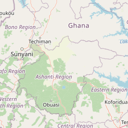
Map view of Bobiri Forest Reserve and Butterfly Sanctuary

Use this park location map to pinpoint Bobiri Forest Reserve and Butterfly Sanctuary in Ghana, understand its exact geographic position, and read its mapped placement within the surrounding landscape more clearly.

Pigeon | © OpenStreetMap contributors

Location context for Bobiri Forest Reserve and Butterfly Sanctuary

Ashanti Region
Park atlas

Discover adjacent forest reserves and regional conservation landscapes in the Ashanti Region

Parks Near Bobiri Forest Reserve and Butterfly Sanctuary: Compare Regional Protected Areas

Compare protected areas near Bobiri Forest Reserve and Butterfly Sanctuary to explore neighboring semi-deciduous forest reserves and regional wildlife habitats. Evaluating adjacent conservation landscapes provides valuable geographic context for understanding tropical forest ecosystems across the region.
Wildlife reserveGhana
About 25 km away#1 closest

North

Bomfobiri Wildlife Sanctuary: Mapped Geography and Protected Landscapes in Central Ghana

A diverse habitat mosaic featuring forests, savanna, and waterfalls.

Bomfobiri Wildlife Sanctuary offers a compressed look at Ghana's natural diversity, where riverine corridors transition into open savanna. The protected area is recognized for its combination of dense forest, varied geological rock formations, and significant natural landmarks like the Lion Stone and local waterfalls, providing a clear perspective on the region's complex physical geography.

Area
53 km²
Established
1975
National parkGhana
About 112 km away#2 closest

South

Kakum National Park: Ghana's Landmark Protected Rainforest and Canopy Walkway

Mapped tropical forest landscape and unique elevated park exploration.

Kakum National Park represents a significant protected area within Ghana, characterized by its 375 square kilometers of moist evergreen tropical rainforest. The park's identity is strongly linked to its iconic canopy walkway, an engineering feat offering elevated views into the forest structure. As a national park, Kakum provides crucial mapped context for understanding West African biodiversity and regional geography, including notable primate populations and the densest concentration of forest elephants in Ghana. Its community-driven establishment also marks it as a key site for participatory conservation examples.

Area
375 km²
Established
1992
IUCN
II
Visitors
135.9K annual
Wildlife reserveBono East Region
About 122 km away#3 closest

North

Boabeng-Fiema Monkey Sanctuary: Geographic Boundaries and Wildlife Reserve Context

Community-protected forest landscapes in Ghana

Boabeng-Fiema Monkey Sanctuary represents a rare community-based wildlife reserve located in central Ghana. Spanning 4.4 square kilometers between the villages of Boabeng and Fiema, the forest provides essential habitat for primate populations protected by generations of cultural tradition. This detail page offers geographic context, map exploration of the forest reserve, and insight into the unique intersection of woodland ecosystems and community-enforced conservation in the Bono East Region.

Area
4.4 km²
Established
1970
Relief
Lowland
Climate
Tropical
National parkBono East Region
About 142 km away#4 closest

Northeast

Digya National Park: Ghana's Oldest National Park, Bordering Lake Volta

Explore its unique geography and mapped protected boundaries.

Digya National Park is a significant protected area in Ghana, renowned as the nation's oldest, established in 1900 and gazetted as a national park in 1971. Occupying 3,743 square kilometers in the Bono East Region, it is distinctively bordered on three sides by the vast Lake Volta, creating an unparalleled terrestrial-aquatic habitat interface. This national park represents a key point in Ghana's geographic atlas, situated in a transitional zone between forest and savanna ecosystems, and is a vital hub for wildlife conservation and the study of its unique landscape character.

Area
3,743 km²
Established
1971
IUCN
II
Relief
Lowland
Wildlife reserveCentral Region
About 154 km away#5 closest

Southeast

Muni-Pomadze Ramsar Site: Protected Coastal Wetlands and Forest Reserves in Ghana

Coastal lagoons, mangrove stands, and undulating hill geography

Covering a compressed sequence of coastal and inland landforms, the Muni-Pomadze Ramsar Site serves as a significant protected landscape. This area encompasses the Muni Lagoon, shoreline dunes, and the forested slopes of the Yenku and Egyasimanku Hills, creating an ecologically diverse habitat that defines the geography of the surrounding coastline.

Area
3 km²
Established
1992
IUCN
II
Protected landscapeWestern Region
About 161 km away#6 closest

Southwest

Mamiri Forest Reserve: Mapped Geography and Protected Landscape Identity in Western Ghana

Ecological transition zone of the Upper Guinea forest block

Spanning roughly 45 square kilometers, Mamiri Forest Reserve is defined by its unusual, elongated geometry and dissected hill-and-valley topography. This protected landscape serves as a vital transition zone between wet and moist evergreen forest types, supporting a complex array of seasonal wetland patches and upland forest ridges. Recognized for its significance as an Important Bird Area, it remains a critical remnant of the original high forest system found in this part of Ghana.

Area
45 km²
Established
1949
IUCN
V
Relief
Upland
A horizontal watercolor painting showing a winding river flowing through a lush marshy landscape with distant hills in the background.
Nature reserveGreater Accra Region
About 165 km away#7 closest

Southeast

Densu Delta Ramsar Site: Coastal Wetland Geography in the Greater Accra Region

Protected nature reserve, lagoon network, and tidal marshland

Located at the mouth of the Densu River, this Ramsar site features an interconnected system of mangroves, salt pans, and shallow lagoons. The protected area serves as an essential coastal buffer and bird habitat, showcasing the complex interplay between riverine freshwater and the marine environment of the Gulf of Guinea.

Area
58.93 km²
Established
1992
Water
Water-dominated
Wildlife reserveGreater Accra Region
About 182 km away#8 closest

Southeast

Sakumo Ramsar Site Wildlife Reserve: Geographic and Protected Landscape Overview

Coastal lagoon and savanna wetland within the Greater Accra Region

Located along the southern coast of Ghana, the Sakumo Ramsar Site functions as a unique wildlife reserve where a seasonally shifting lagoon meets freshwater marshes and coastal savanna. This map-focused profile examines the ecological boundaries and terrain features of this significant wetland, which serves as a vital sanctuary for migratory birds despite its position within the dense urban fabric of the Accra-Tema metropolitan area.

Area
14 km²
Established
1992
Relief
Lowland
Climate
Tropical

Common questions about visiting, size, designation, and location context for Bobiri Forest Reserve and Butterfly Sanctuary

Bobiri Forest Reserve and Butterfly Sanctuary FAQs for park facts, access, geography, and protected area context

Find quick answers about Bobiri Forest Reserve and Butterfly Sanctuary, including protected-area facts, park geography, trail and visitor context, and how the park fits into its surrounding country and regional landscape.
MoriAtlas Explorer

Continue Your Protected Areas Search Across the Global Atlas

Deepen your exploration by continuing the structured search for national parks and protected areas worldwide. Utilize the comprehensive filtering capabilities to compare different conservation landscapes and refine your understanding of global park geography. Discover more about the distribution and characteristics of protected natural areas.

Global natural geography