
Mori Atlas logo
Nature reserveBong’sche Kiesgrube und Mainufer bei Mainflingen

Examine the riparian woodland, lake mosaics, and wetland geography of this riverfront reserve.

Bong’sche Kiesgrube und Mainufer bei Mainflingen: A Protected Nature Reserve in Hessen

(Naturschutzgebiet Bong'sche Kiesgrube und Mainufer bei Mainflingen)

Bong’sche Kiesgrube und Mainufer bei Mainflingen stands as a significant protected nature reserve in the state of Hessen, Germany. Encompassing ninety-five hectares along the Main river, the terrain features a mosaic of post-industrial gravel pits, open water bodies, and floodplain forests. This geographic configuration creates an essential haven for migratory waterbirds and riparian ecosystems within the Rhine-Main metropolitan landscape.

nature reservewetlandgravel pit lakesriver floodplainMain riverbird sanctuary
A flat vector-style illustration showing a serene lake with cattails in the foreground, forest-covered hills, and a pale sun in the background.

Bong’sche Kiesgrube und Mainufer bei Mainflingen

Nature reserve

Park overview

Structured park overview, official facts, and landscape profile for Bong'sche Kiesgrube und Mainufer bei Mainflingen

Bong'sche Kiesgrube und Mainufer bei Mainflingen park facts, protected area profile, and essential visitor context

Review the core facts for Bong'sche Kiesgrube und Mainufer bei Mainflingen, including designation, size, terrain, visitor scale, habitats, and operating context in one park-focused overview.

About Bong'sche Kiesgrube und Mainufer bei Mainflingen

Bong'sche Kiesgrube und Mainufer bei Mainflingen is one of the more ecologically distinctive small reserves in the Rhine-Main region. Although it covers only around 95 hectares, it combines two complementary habitats: a cluster of lakes developed from former clay and gravel workings and stretches of natural Main river shoreline with associated floodplain vegetation. Together these create a habitat mosaic that supports rich birdlife, amphibians, and insects in an otherwise heavily urbanized part of Hesse.

The reserve sits south of the village of Mainflingen, wedged between the federal motorway A45 to the east and the L2310 state road to the south. This location within the densely populated Rhine-Main conurbation makes the site particularly valuable, since truly natural wetland and shoreline habitats are scarce in the immediate surroundings. The protected area offers a concentrated patch of open water, reed zones, and riparian woodland where wildlife can retreat from intensive agricultural and urban land use.

Administratively, the site is a so-called Naturschutzgebiet under the German nature conservation system, managed by the lower nature conservation authority (Untere Naturschutzbehörde) of the Offenbach district. Its IUCN classification as a Category IV habitat and species management area reflects its primary role in actively supporting specific species and habitats rather than functioning as a strict wilderness reserve. The co-designation as an EU Bird Protection Area ('Vogelschutzgebiet') since 2002 underlines its cross-border relevance for bird conservation.

For visitors and ornithologists, Bong'sche Kiesgrube represents an accessible, compact birding site with a surprising diversity of species. The lake area concentrates waterfowl, grebes, cormorants, and herons, while the Main bank with its willow-dominated floodplain trees supports woodland and shrub-breeding species. The combination of habitats on such a small scale is what gives the reserve its special character within the Hessian protected-area network.

Quick facts and research context for Bong'sche Kiesgrube und Mainufer bei Mainflingen

Bong'sche Kiesgrube und Mainufer bei Mainflingen is a nature reserve (Naturschutzgebiet) in Mainhausen, in the Offenbach district of Hesse, Germany. It encompasses approximately 94.52 hectares of lake and shoreline habitat along the Main river, situated south of the village of Mainflingen between the A45 motorway and a regional road. The reserve was formally designated in 1977 and is classified as an IUCN Category IV habitat and species management area. Since 2002, it has also been an EU Bird Protection Area, recognized for its role as a resting, wintering, and breeding area for waterbirds.

Protection and recognition

Documented conservation parameters and recognized protected area records

Bong’sche Kiesgrube und Mainufer bei Mainflingen Protection Status and International Recognition

Examine the verified protection status and administrative records associated with Bong’sche Kiesgrube und Mainufer bei Mainflingen. Access structured database references including official registry identifiers for global natural areas.

Protection details

WDPA ID
81441
Park context

Deeper park guide and search-rich context for Bong'sche Kiesgrube und Mainufer bei Mainflingen

Bong'sche Kiesgrube und Mainufer bei Mainflingen history, landscape, wildlife, and travel context

Explore Bong'sche Kiesgrube und Mainufer bei Mainflingen through its history, landscape character, ecosystems, wildlife, conservation priorities, cultural context, and seasonal travel timing in a structured park guide built for atlas discovery and search intent.

Why Bong'sche Kiesgrube und Mainufer bei Mainflingen stands out

The reserve is best known as an important regional refuge for waterbirds along the Main river. The lake landscape created by former gravel workings provides open water and shallow shoreline habitats that attract a wide variety of ducks, grebes, herons, and other water-dependent species, especially during migration and winter months. Equally important is the combination of these artificial lake habitats with near-natural floodplain vegetation along the river. The juxtaposition of old industrial extraction land and recovering riparian ecosystems makes the site a textbook example of how former quarries can regain significant ecological value once protected.
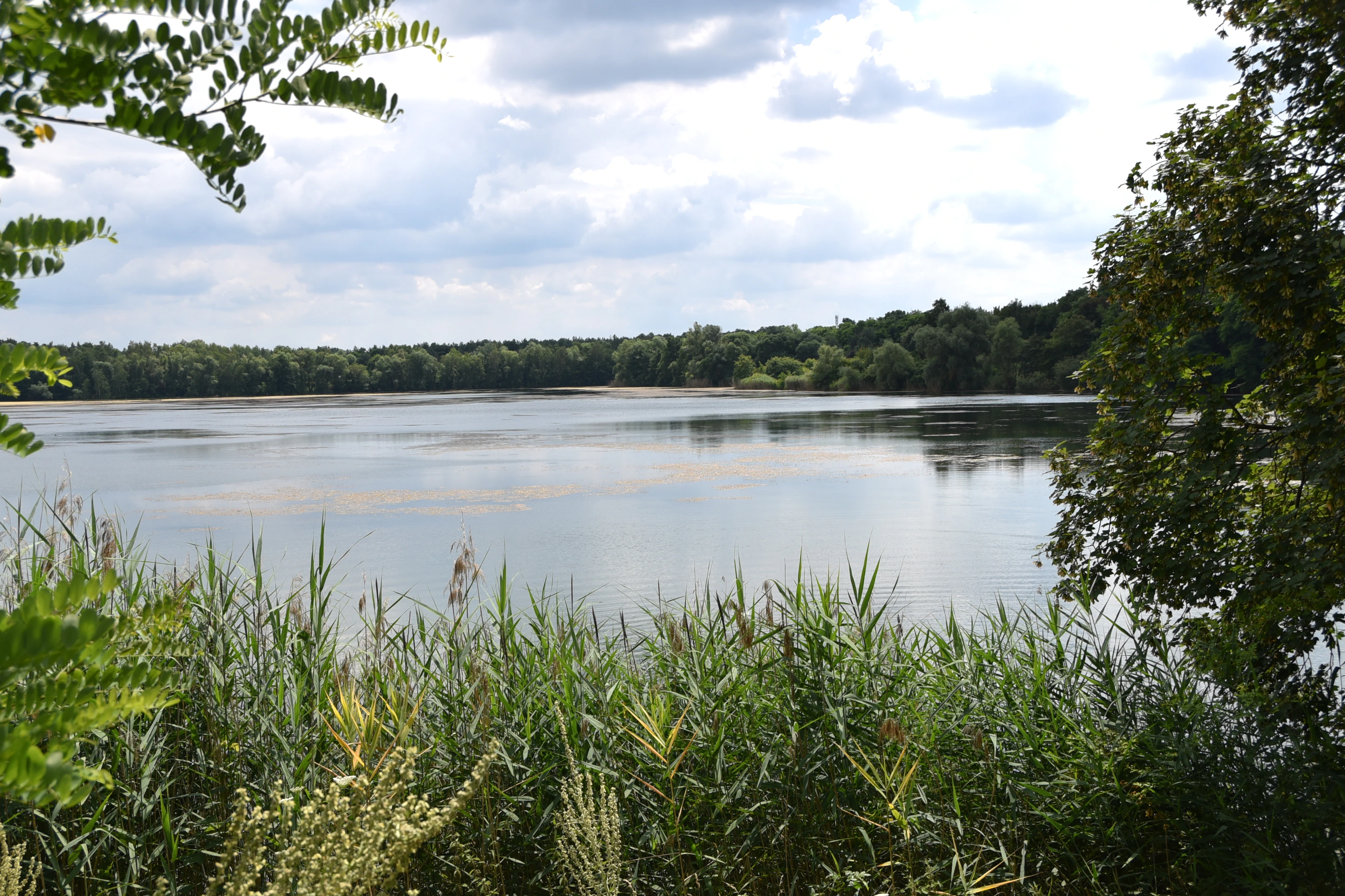
A wide view of a calm lake surrounded by trees and tall reeds in a nature reserve under a cloudy sky.
A view of the Bongsche Kiesgrube nature reserve, characterized by its tranquil wetland lake surrounded by lush riparian vegetation.

Bong'sche Kiesgrube und Mainufer bei Mainflingen history and protected-area timeline

The landscape history of the reserve is unusual in that the habitat itself is largely a product of industrial activity. Around 1920, clay was extracted on the site that later became the protected area, and by approximately 1933 the economically viable deposits had been exhausted. The quarried pits gradually filled with water, beginning the long transition that would eventually lead to today's lake landscape.

From the early 1960s, sand and gravel extraction began within what is now the lake area. This more recent phase of mining shaped the present-day water bodies and shore profile. In 1976, the Bong milling works (Bong'sches Mahlwerk) ceased operation, though a sand-washing plant inside the protected area and clay extraction in the Bong clay pit (Bong'sche Lehmgrube) continued into the 1990s. The result is a mosaic of pits of varying ages and depths, which today constitute the reserve's core habitat.

The area was formally designated as a nature reserve (Naturschutzgebiet) in 1977 under the federal nature conservation identification number 1438001. The designation was pushed forward on the initiative of the Hessian Society for Ornithology and Nature Conservation (Hessische Gesellschaft für Ornithologie und Naturschutz, HGON), which saw the ornithological potential of the recovering wetland landscape. In 2002, the same area was simultaneously designated as an EU Bird Protection Area (Vogelschutzgebiet) under identification number 5920-401, locking in its importance at the European level.

In the decades since these designations, management of the site has continued under the jurisdiction of the lower nature conservation authority of the Offenbach district. The combination of legal protection, ecological recovery, and ongoing former-industrial land use defines the present character of the reserve.

What was once a sequence of clay pits and then an active gravel quarry has, through the protection regime established in 1977 and reinforced in 2002, become one of the more important bird sites in the Rhine-Main area today. The reserve's story illustrates how carefully managed post-industrial landscapes can develop substantial conservation value within just a few decades.

Bong'sche Kiesgrube und Mainufer bei Mainflingen landscape and geographic character

The landscape of Bong'sche Kiesgrube und Mainufer bei Mainflingen is shaped by two clearly distinguishable elements: an inland lake-and-pit system and a stretch of riverbank along the Main. Together they form a compact yet varied mosaic that contrasts with the surrounding agricultural and urban land of the Offenbach district.

The lake area occupies the larger share of the reserve and consists of a series of water bodies of different sizes and ages. These resulted from progressive clay and gravel extraction between roughly 1920 and the 1990s. As quarrying moved across the landscape, abandoned pits filled with water, creating a chain of lakes and ponds separated by low embankments, strips of land, and patches of vegetation. The shoreline is irregular and partly steep, offering varied depths and structural niches along the water.

Surrounding and connecting the water bodies are areas of open ground, scrub, and light woodland. Along the borders of the reserve, where land was not quarried, more mature vegetation has developed, including parts of the floodplain forest typical of the Main river. The transition from open water to scrubby shore and then to denser woodland is gradual in many places, creating well-buffered habitat edges.

Directly bordering the lakes lies the active floodplain of the Main river itself. This riparian zone includes soft riverbanks, gravel and sand bars where water levels permit, and riparian woodland dominated by willows and other water-tolerant tree species. The river brings dynamics, sediment movement, and occasional flooding that influence the inland lakes as well. Together the two elements combine to form a hydrologically interconnected landscape of water, shore, and riverbank that defines the visual and ecological identity of the reserve.

Bong'sche Kiesgrube und Mainufer bei Mainflingen ecosystems, habitats, and plant life

Ecologically, Bong'sche Kiesgrube und Mainufer bei Mainflingen is a hybrid system, formed by standing water and running water working in concert. The lake complex is the dominant element, but the bordering Main floodplain fundamentally shapes the biological character of the whole reserve. The combination of slow-moving or still water with periodic freshwater flow and nutrient exchange from the river creates conditions that support a wide range of plant and animal communities despite the small total area.

The water bodies themselves range from open expanses to more sheltered, partially overgrown sections. Some edges have developed reed beds and floating vegetation typical of nutrient-rich lowland lakes, while other shorelines remain open and gravelly. This structural diversity supports a corresponding diversity of aquatic and semi-aquatic organisms, from submerged aquatic plants along shallow margins to emergent reed vegetation in sheltered corners.

Beyond the open water, the vegetation pattern includes a gradient of habitats. Immediately around the lakes, pioneer vegetation and scrub have established on abandoned quarry surfaces. Further out and along the Main, more stable habitats appear, including riparian woodland, tall herb communities, and patches of near-natural floodplain forest. This habitat mosaic reinforces the site's ecological value: a small area of land can support many different microhabitats, each with its own characteristic species.

Birdlife is the most conspicuous component of the reserve's nature, but the site also supports reptiles, amphibians, dragonflies, and other invertebrates whose life cycles depend on the combination of open water, sheltered banks, and natural vegetation. The protected status safeguards these habitats against further extraction and disturbance, allowing ecological recovery processes to continue.

Bong'sche Kiesgrube und Mainufer bei Mainflingen wildlife and species highlights

Wildlife is the most visible ecological asset of Bong'sche Kiesgrube und Mainufer bei Mainflingen, and birds dominate the site's profile. The combination of open water, shallow margins, reed beds, and adjacent riparian forest provides habitat for waterbirds, waders, herons, and a wide range of songbirds throughout the year.

The lake area serves especially as a resting, wintering, and breeding area for waterbirds. In colder months, the open water supports gatherings of ducks, grebes, and cormorants, while the shallower edges and small islands attract herons and similar wading species. During migration periods in spring and autumn, the site is used as a stopover point, sometimes by regionally rare visitors that draw birdwatchers from Hesse and beyond.

Shrubby and wooded margins hold a separate set of species. Warblers, flycatchers, tits, and other small passerines breed along the lake and in the floodplain woodland. Birds of prey, including several typical lowland species, use the area for hunting. The mixing of habitats within such a compact reserve allows a surprising diversity to occur within a small radius.

Amphibians benefit from the combination of standing water for breeding and moist terrestrial habitats nearby. Insects, especially dragonflies and various water-dependent groups, are also notable elements of the wildlife community. The reserve's formal designation under the EU Birds Directive emphasizes that the site's protection is centered on sustaining these bird populations, but the broader wildlife community is an integral part of what makes the area ecologically significant.

Bong'sche Kiesgrube und Mainufer bei Mainflingen conservation status and protection priorities

From a conservation perspective, Bong'sche Kiesgrube und Mainufer bei Mainflingen is significant because it preserves a high-quality wetland complex in a region where such habitats are increasingly rare. The Rhine-Main area is one of the most densely populated and intensively used parts of Germany, and naturally undeveloped shoreline and waterbird habitat is scarce. The reserve therefore plays an important role as a refuge for species that would otherwise struggle to find suitable conditions in the surrounding landscape.

Its designation as a Naturschutzgebiet under the German nature conservation framework gives the site a strong legal basis for protection. The status restricts damaging activities such as further extraction, intensive recreational use, and major infrastructure works. At the European level, the site has been part of the Natura 2000 network as a Bird Protection Area since 2002, which highlights its value not only for local biodiversity but also for maintaining viable populations of bird species at the continental scale.

The conservation rationale of the site is explicitly tied to waterbirds as well as associated species such as amphibians and insects, while still protecting the near-natural floodplain vegetation of the Main. This combination of objectives means that the reserve is not only about preserving one species group but also about maintaining the structural integrity of the habitats those species depend on.

Management is led by the lower nature conservation authority of the Offenbach district, under the framework of Hessian nature conservation law. Active conservation here rests primarily on protection from disturbance, control of land use around the reserve, and long-term monitoring of bird populations. The origin of the protected area, based on the initiative of the Hessian Society for Ornithology and Nature Conservation, illustrates the close relationship between scientific monitoring and formal protection that has shaped the site's modern conservation value.

Bong'sche Kiesgrube und Mainufer bei Mainflingen cultural meaning and human context

The cultural context of this reserve is tightly bound to the recent industrial past of the site and to the broader cultural identity of the Main river as a heavily used waterway in central Germany. The shape of the lakes, the shoreline structures, and the layout of the reserve all reflect a history of clay and gravel extraction that was economically important to the local area in the twentieth century.

The naming of the reserve still references these earlier industrial activities. 'Kiesgrube' literally means gravel pit, and 'Bong' refers to the historical operators of the mining works. Today, these names carry a different meaning, signaling not active industry but rather the recovery of an industrial site into a habitat valued for nature conservation. This transition is itself part of the broader story of post-industrial landscape change in Hesse.

Waterways like the Main have long played a role in regional identity and daily life, supporting commerce, transport, fishing, and recreation. The fact that the reserve includes a stretch of the Main shoreline acknowledges this cultural element and reflects the river's continuing central importance to Mainhausen and the surrounding area. The protection of the riverbank is therefore as much about safeguarding landscape and ecological values tied to the Main as it is about preserving the lake habitats separately.

At a wider scale, the reserve fits into the pattern of small but ecologically meaningful protected sites that surround major German cities, offering residents accessible places for nature engagement while contributing to national and European biodiversity targets.

Top sights and standout views in Bong'sche Kiesgrube und Mainufer bei Mainflingen

The principal highlight of Bong'sche Kiesgrube und Mainufer bei Mainflingen is its lake-and-riverbank mosaic, which in such a compact form supports an exceptional diversity of waterbirds. Within roughly 95 hectares, the reserve combines open water, reed-edged shorelines, scrub, floodplain woodland, and active Main riverbank, allowing many species to coexist in close proximity.

Another key highlight is the site's designation as both a national nature reserve and an EU Bird Protection Area, a status that signals its double-tier importance under German and European conservation frameworks. For visitors, the highlight is the opportunity to experience a high-quality bird site within the Rhine-Main metropolitan region, where such habitats are otherwise rare.

The combination of post-industrial origin, formal nature conservation protection, and ongoing ecological recovery gives the reserve a distinctive profile. It illustrates how former extraction landscapes can be transformed into recognized protected areas that are valued both for biodiversity and for their contribution to regional quality of life.

Best time to visit Bong'sche Kiesgrube und Mainufer bei Mainflingen

The reserve offers different experiences through the year, shaped primarily by waterbird movements and vegetation cycles. In winter, the open water of the former gravel pits becomes especially attractive, often concentrating ducks, grebes, cormorants, and other waterbirds that use the area as a cold-season refuge.

Spring and autumn are typically the most rewarding periods for observing migratory species passing through or stopping over. During these seasons, water levels, light conditions, and weather can vary, but generally they provide the highest chance of encountering varied species in a single visit.

In summer, breeding waterbirds, amphibians, and insects are at their most visible, and the floodplain woodland along the Main is in full leaf. However, dense summer vegetation may make some viewing and photography more difficult than in the colder months.

Overall, the cooler and transitional seasons tend to be the most popular with birdwatchers, while summer brings a different, more vegetation-centered experience. The reserve's protected status means disturbance should be kept low in all seasons, with visitors generally staying on designated paths.

Monthly climate preview

Long-term representative monthly temperature and precipitation data for Hessen

Bong’sche Kiesgrube und Mainufer bei Mainflingen Climate Normals and Temperature Rhythms

Representative coordinates record measured monthly temperature swings from freezing winter lows to mid-summer maximums alongside steady year-round precipitation rates. Examining the full twelve-month profile reveals detailed baseline climate normals and monthly meteorological variations across the protected area.
Annual mean10 °C
0 °C21 °C
Jan
Feb
Mar
Apr10°
May14°
Jun18°
Jul21°
Aug20°
Sep15°
Oct10°
Nov
Dec
Warmest month
July

20.6 °C

Coolest month
January

0.2 °C

Wettest month
July

2.2 mm/day

Driest month
April

1.4 mm/day

Park location guide

Geography guide, regional context, and park location map for Bong'sche Kiesgrube und Mainufer bei Mainflingen

Bong'sche Kiesgrube und Mainufer bei Mainflingen park geography, regions, and map view in Germany

Understand where Bong'sche Kiesgrube und Mainufer bei Mainflingen sits in Germany through a broader geographic reading of the surrounding landscape, nearby location context, and its mapped position within the national park landscape.

How Bong'sche Kiesgrube und Mainufer bei Mainflingen fits into Germany

Germany is a federal republic in Western and Central Europe with a population of over 83 million across sixteen constituent states. It is Europe's largest economy by nominal GDP and a major global exporter and importer. The capital is Berlin, and the country borders Denmark, Poland, Czech Republic, Austria, Switzerland, France, Luxembourg, Belgium, and the Netherlands.

Wider geography shaping Bong'sche Kiesgrube und Mainufer bei Mainflingen in Germany

Germany is located in Western and Central Europe, spanning 357,022 km². It borders Denmark to the north, Poland and the Czech Republic to the east, Austria and Switzerland to the south, and France, Luxembourg, Belgium, and the Netherlands to the west. The country has coastlines on the Baltic Sea and North Sea to the north, with the Alps located in the southern region.

Map view of Bong'sche Kiesgrube und Mainufer bei Mainflingen

Use this park location map to pinpoint Bong'sche Kiesgrube und Mainufer bei Mainflingen in Germany, understand its exact geographic position, and read its mapped placement within the surrounding landscape more clearly.

Pigeon | © OpenStreetMap contributors

Location context for Bong'sche Kiesgrube und Mainufer bei Mainflingen

Hessen

Explore the wetland habitats, gravel pit lakes, and riparian woodlands of this protected river sanctuary

Visualizing Bong’sche Kiesgrube und Mainufer bei Mainflingen Photos, Landscapes, and Scenery

Visual records reveal the distinctive landscape character and wetland habitats found across Bong’sche Kiesgrube und Mainufer bei Mainflingen. Detailed photography helps observers understand the terrain, shoreline ecosystems, and riverine environment preserved within the nature reserve.

A wide view of a calm lake surrounded by trees and tall reeds in a nature reserve under a cloudy sky.

Park atlas

Compare surrounding regional geography and connected protected landscapes

Other Parks and Protected Areas Near Bong’sche Kiesgrube und Mainufer bei Mainflingen

Browsing other protected areas near Bong’sche Kiesgrube und Mainufer bei Mainflingen reveals broader regional patterns in river floodpipes and wetland habitats. Examining adjacent conservation zones provides valuable context for understanding the wider ecological networks of central Germany.
A horizontal watercolor painting showing a calm lake with marshy shores, distant tree lines, and pine branches framing the top and bottom corners, rendered in soft pastel greens and pinks.
Nature reserveHessen
About 1.9 km away#1 closest

South

Ehemalige Tongrube von Mainhausen: Protected Nature Reserve and Wetland Habitat in Hessen

A vital sanctuary for waterbirds in the lower Main river valley

Explore the Ehemalige Tongrube von Mainhausen, an essential protected area in Hessen, Germany. Formed from a former clay pit, this site preserves a 15 hectare lake and diverse floodplain vegetation, functioning as a vital breeding and resting ground for numerous waterfowl species within the heavily modified lower Main valley.

Area
0.156 km²
Established
2005
IUCN
IV
Relief
Lowland
A soft watercolor illustration of a wetland scene with a calm pool of water, grassy banks, a line of trees, and distant rolling hills against a white background.
Nature reserveHesse
About 2.7 km away#2 closest

Northwest

Affelderchen und Rettichbruch von Klein-Welzheim: Protected Wetland Nature Reserve in Hesse

Examining the ecological landscape and hydrology of this German protected area

Affelderchen und Rettichbruch von Klein-Welzheim is a notable nature reserve in Hesse characterized by its wet meadows and marshy woodland. This geographic study covers the protected site's transition from an agricultural lowland depression to a dynamic, beaver-influenced wetland system that supports endangered plant species and diverse breeding avian populations.

Area
0.512 km²
Established
1983
Relief
Lowland
Scope
Terrestrial
Nature reserveLandkreis Offenbach
About 3.5 km away#3 closest

West

Langhorst von Hainburg und Seligenstadt: Geography of a Main Valley Nature Reserve

Protected floodplain forest and wet meadows in Landkreis Offenbach

Langhorst von Hainburg und Seligenstadt is a key nature reserve in Landkreis Offenbach, Germany. This protected area showcases a preserved floodplain mosaic, featuring structurally diverse broadleaf forest, open wet meadows, and historical stream relics of the Main river system, serving as an essential ecological refuge within a densely populated region.

Area
0.823 km²
Established
1996
IUCN
IV
Relief
Lowland
A pale, horizontal watercolor painting showing a grassy floodplain, scattered deciduous trees, a gentle path or stream winding through the center, and a soft, pastel-toned sky.
Nature reserveHessen
About 6.5 km away#4 closest

Northwest

Pechgraben bei Klein-Krotzenburg Nature Reserve in the Hessen Protected Landscape Network

A preserved mosaic of ancient floodplain terrain and wetland habitats.

Located in the Offenbach district, this nature reserve protects a rare post-glacial flood channel of the Main river. The site exhibits a diverse landform mosaic, ranging from near-natural broadleaf forests to expansive sedge marshes. It functions as a critical protected geography for regional species, maintaining its ecological character against the surrounding agricultural and residential development of the Lower Main valley.

Area
0.341 km²
Established
1998
IUCN
IV
Relief
Lowland
Nature reserveHessen
About 6.7 km away#5 closest

Southwest

Mooskiefernwald von Dudenhofen: Mapped Nature Reserve and Protected Pine Woodland in Hessen

Regional landscape context and protected area boundaries

Study the geographic composition of Mooskiefernwald von Dudenhofen, a specialized nature reserve in Hessen. This 36-hectare site features a rare moss-pine woodland environment and sandy soil habitats, offering a distinct contrast to the industrial and suburban landscape of the Rodgau area.

Area
0.361 km²
Established
1999
IUCN
IV
Nature reserveLandkreis Offenbach
About 6.8 km away#6 closest

Northwest

Kortenbach bei Froschhausen Nature Reserve: Geographic Mapping and Protected Forest Overview

Hardwood floodplain woodland in Landkreis Offenbach

Kortenbach bei Froschhausen protects a compact, groundwater-influenced forest ecosystem within the Offenbach district. This nature reserve acts as a critical refuge for mature broadleaf trees, including the rare European white elm. Our atlas entry focuses on the site's stream-fed terrain and its role as a preserved forest fragment amidst surrounding agricultural and transport infrastructure.

Area
0.405 km²
Established
1998
IUCN
IV
Nature reserveLandkreis Offenbach
About 7.1 km away#7 closest

West

Rotsohl und Thomassee von Dudenhofen Nature Reserve in Landkreis Offenbach, Germany

Protected pine forest, wetland habitat, and pond mosaic

Spanning 52 hectares in the Rhine-Main lowlands, this nature reserve is defined by its compact interplay of dry pine forest and diverse wet open habitats. Known for the Postteiche and Weißensee ponds, it serves as a significant site for both breeding and migratory bird populations in a densely settled metropolitan region.

Area
0.519 km²
Established
1999
IUCN
IV
A soft watercolor painting showing a tranquil wetland landscape with calm water, grassy shores, and hazy mountains in the background.
Nature reserveHessen
About 11 km away#8 closest

Southwest

Kies- und Sandgrube von Dudenhofen: Regional Nature Reserve and Wetland Mapping

Protected post-extraction landscape in the Hessen region

Kies- und Sandgrube von Dudenhofen protects a distinct network of shallow-water habitats and open-ground terrain near Rodgau. Managed as a nature reserve, this area serves as an essential regional hub for wetland biodiversity, mapping the transition between industrial remnants and regenerated forest ecosystems within the Rhine-Main lowlands.

Area
0.173 km²
Established
1995
IUCN
IV

Common questions about visiting, size, designation, and location context for Bong'sche Kiesgrube und Mainufer bei Mainflingen

Bong'sche Kiesgrube und Mainufer bei Mainflingen FAQs for park facts, access, geography, and protected area context

Find quick answers about Bong'sche Kiesgrube und Mainufer bei Mainflingen, including protected-area facts, park geography, trail and visitor context, and how the park fits into its surrounding country and regional landscape.
MoriAtlas Explorer

Continue Your Protected Areas Search Across the Global Atlas

Deepen your exploration by continuing the structured search for national parks and protected areas worldwide. Utilize the comprehensive filtering capabilities to compare different conservation landscapes and refine your understanding of global park geography. Discover more about the distribution and characteristics of protected natural areas.

Global natural geography