
Mori Atlas logo
Nature reserveBorgfelder Wümmewiesen

Mapping the ecological boundaries and wetland terrain of a significant Wümme river floodplain.

Borgfelder Wümmewiesen: An Extensive Nature Reserve and Protected Floodplain in Bremen, Germany

(Naturschutzgebiet 'Borgfelder Wümmewiesen')

Borgfelder Wümmewiesen represents a sprawling 688-hectare nature reserve situated within the floodplain of the Wümme river in Bremen. This protected landscape is defined by its wide, treeless wet grasslands, intricate network of drainage ditches, and seasonal winter flooding that supports critical bird populations. As one of the largest protected areas in the region, the site functions as a key wetland habitat and a managed cultural landscape that serves as a vital staging point for migratory waterfowl.

wet meadowsfloodplainnature reservemeadow birdsbird protection areaNatura 2000
An illustrative depiction of a scenic wetland landscape with a winding river, tall grasses in the foreground, a wooden barn in the middle ground, and distant hills under a partly cloudy sky.

Borgfelder Wümmewiesen

Nature reserve

Park overview

Structured park overview, official facts, and landscape profile for Borgfelder Wümmewiesen

Borgfelder Wümmewiesen park facts, protected area profile, and essential visitor context

Review the core facts for Borgfelder Wümmewiesen, including designation, size, terrain, visitor scale, habitats, and operating context in one park-focused overview.

About Borgfelder Wümmewiesen

Borgfelder Wümmewiesen is one of the defining protected natural areas of Bremen, anchoring the northeastern edge of the city in the broad floodplain of the Wümme river. Covering 688 hectares, it is the largest nature reserve within the city limits and the second-largest in the entire state of Bremen. Its scale, openness, and ecological continuity make it a central element of Bremen's network of protected landscapes and an important refuge for species that depend on extensive wet grassland and undisturbed floodplain conditions.

The reserve lies in the Wümmeniederung, the lowland floodplain of the Wümme, in the Bremen districts of Borgfeld and Oberneuland, between the city and the neighboring municipality of Lilienthal. It is bordered on the west by the Untere Wümme nature reserve and on the east by the Fischerhuder Wümmeniederung reserve, while the former Sodenstich reserve was incorporated into Borgfelder Wümmewiesen in 2015. Within this broader landscape, Borgfelder Wümmewiesen functions as the core wet-grassland area, forming a continuous belt of protected floodplain habitat.

The character of the area is shaped by water. The Wümme runs along the southern edge of the reserve, while the Wümme north arm defines parts of its eastern boundary. In winter, the meadows are regularly flooded, transforming the flat terrain into a temporary wetland. The reserve is dominated by open grassland, traversed by numerous drainage ditches and small water bodies, and largely free of trees except along the margins. Habitat diversity is high, with small and large sedge communities, tall herb vegetation, reedbeds, and flood-tolerant grassland all present.

Beyond its ecological function, Borgfelder Wümmewiesen is also a managed cultural landscape. Some meadows and pastures continue to be used extensively, while others lie fallow, allowing vegetation to develop more naturally. Since the late 1980s, additional small ponds have been created across the area, creating habitat for amphibians and dragonflies and increasing the structural richness of the floodplain. Parts of the reserve are evolving into a near-natural floodplain ecosystem without active land use, illustrating a balance between conservation, traditional land management, and natural dynamics.

The reserve is also significant at the national and European scale. It largely overlaps with an EU Bird Protection Area (Vogelschutzgebiet) of about 682 hectares and partially falls within the FFH site 'Untere Wümme'. Since 2006, management has been carried out by Stiftung NordWest Natur in cooperation with WWF Germany, with oversight from Bremen's Senator für Umwelt, Bau und Verkehr. A comprehensive revision of the reserve's legal ordinance in 2015 modernized the protection framework and incorporated the former Sodenstich area, strengthening the reserve's role as Bremen's flagship floodplain protection site.

Quick facts and research context for Borgfelder Wümmewiesen

Borgfelder Wümmewiesen is the largest nature reserve within the city of Bremen and the second-largest in the state of Bremen, covering 688 hectares in the Wümmeniederung floodplain. It lies in the districts of Borgfeld and Oberneuland, northeast of the city center, and borders the neighboring reserves Untere Wümme and Fischerhuder Wümmeniederung. Established under protection on 3 April 1987, the reserve largely coincides with a 682-hectare EU Bird Protection Area and partly overlaps with the Untere Wümme Habitat Directive (FFH) site.

The reserve is a wet meadow and floodplain cultural landscape that is regularly inundated in winter, crossed by the Wümme river and the Wümme north arm, and dotted with ditches and small water bodies. Since the late 1980s, many small ponds have been created to support amphibians and dragonflies. The area is nationally significant for breeding populations of waders and rails, and serves as an important resting and wintering area for migratory waterfowl.

Protection and recognition

Documented terrestrial protection history and Natura 2000 designation records

Borgfelder Wümmewiesen Protection Status and International Recognition

Borgfelder Wümmewiesen maintains documented terrestrial protection status established in 1987 under official conservation frameworks. Official records incorporate verified Natura 2000 designation details alongside baseline management metrics for this protected area.

International recognition

Protection details

Protection scope
Terrestrial
Designated year
1987
Transboundary protection
No
WDPA ID
555537384
Park context

Deeper park guide and search-rich context for Borgfelder Wümmewiesen

Borgfelder Wümmewiesen history, landscape, wildlife, and travel context

Explore Borgfelder Wümmewiesen through its history, landscape character, ecosystems, wildlife, conservation priorities, cultural context, and seasonal travel timing in a structured park guide built for atlas discovery and search intent.

Why Borgfelder Wümmewiesen stands out

The reserve is best known for being Bremen's largest and most important wet-meadow nature reserve, providing critical breeding habitat for meadow birds such as lapwings, snipe, black-tailed godwits, and a nationally significant population of rails. It is also valued as a winter refuge for large numbers of ducks, geese, and swans in the Wümme floodplain. Equally distinctive is the landscape itself: a vast, mostly treeless wet grassland that is regularly shaped by winter flooding, intersected by ditches and small ponds, and bordered by the meandering Wümme river. This combination of dynamic floodplain ecology and traditional cultural landscape gives the area its strong ecological character and conservation value.
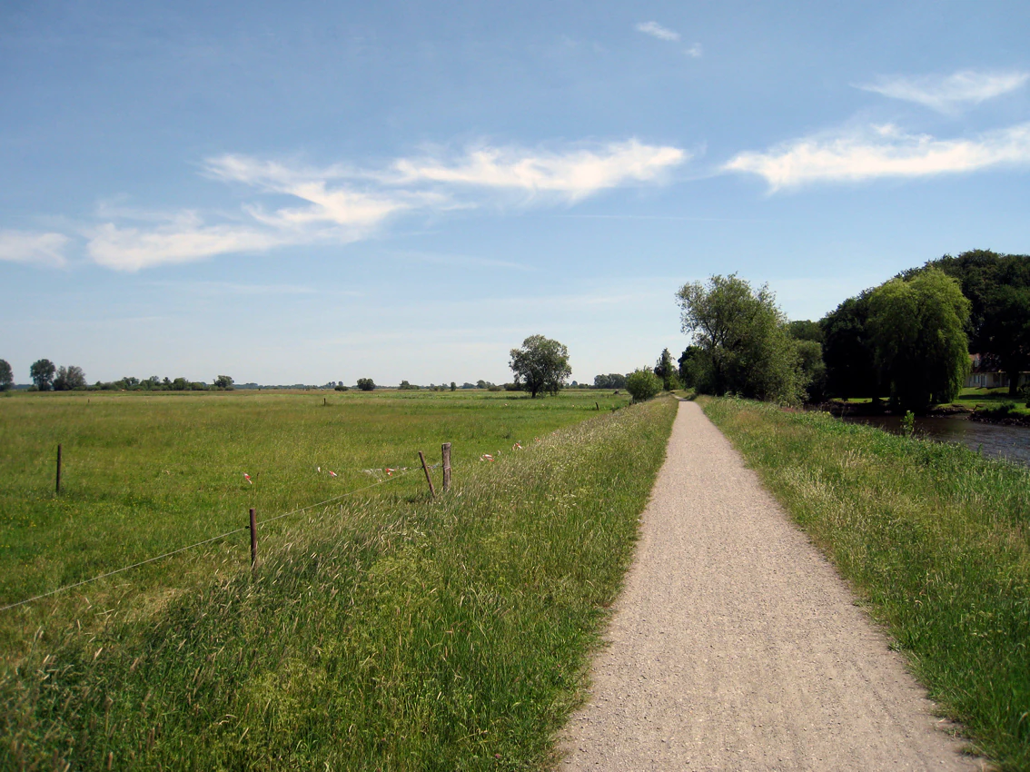
A wide, gravel walking path leads into the distance, with green meadows on the left and trees along a river bank on the right under a blue, partly cloudy sky.
A gravel path runs along the Wümme river through the meadows of the Borgfelder Wümmewiesen nature reserve.

Borgfelder Wümmewiesen history and protected-area timeline

The designation of Borgfelder Wümmewiesen as a protected area was the result of a longer process of national-level recognition of the site's environmental significance. In 1985, the area was included in the German program for the establishment and safeguarding of parts of nature and landscape of nationally representative importance, marking it as a conservation priority at the federal scale. Two years later, on 3 April 1987, it was formally placed under nature protection (Naturschutz) as the seventh reserve registered in Bremen's nature protection book.

Since the late 1980s, active conservation management has shaped the reserve. Numerous small water bodies were created to enhance habitat availability for amphibians and dragonflies, and grazing or mowing practices were tailored to support meadow-breeding bird populations. These measures transformed parts of the area into a more diverse wetland mosaic while preserving the open character of the main meadows.

In 1999, the Stiftung NordWest Natur was founded, and from June 2006 onward it assumed responsibility for managing Borgfelder Wümmewiesen in cooperation with WWF Germany. This partnership introduced a more structured, foundation-led approach to habitat management, monitoring, and visitor engagement. On 30 May 2015, a new overarching ordinance comprehensively updated the reserve's legal framework and formally integrated the former Sodenstich nature reserve into Borgfelder Wümmewiesen, expanding the protected area and consolidating its role as a single, large floodplain reserve administered by the city's environmental authority.

Borgfelder Wümmewiesen landscape and geographic character

Borgfelder Wümmewiesen occupies a flat stretch of the Wümme floodplain, with surface elevations ranging only from about 1.5 to 3.5 meters above sea level. This low, level terrain is the defining feature of the landscape: a wide, open expanse of wet grassland shaped almost entirely by water dynamics rather than by relief. The area is essentially treeless across its core, with trees limited to the margins, giving the reserve its distinctive open, expansive character.

The Wümme river flows along the southern edge of the reserve, while the Wümme north arm bounds parts of the eastern side. Together, these channels frame the meadows and contribute to the seasonal flooding regime. The floodplain is dissected by a dense network of drainage ditches and small, still water bodies, which break up the open grassland into a finely patterned mosaic of wet habitats.

During winter, the reserve regularly transforms into a shallow temporary wetland as floodwaters spread across the meadows, before receding again in spring and summer to reveal damp grassland. This seasonal rhythm of inundation and drying has produced a floodplain cultural landscape of marked visual openness, where the absence of trees and the dominance of grass, sedge, reed, and water create a wide, often windswept scenery typical of northern German lowland river valleys. Part of the area is evolving toward a naturally dynamic floodplain without active land use, adding structural variation through scrub development and natural channel formation in addition to the traditionally managed meadows.
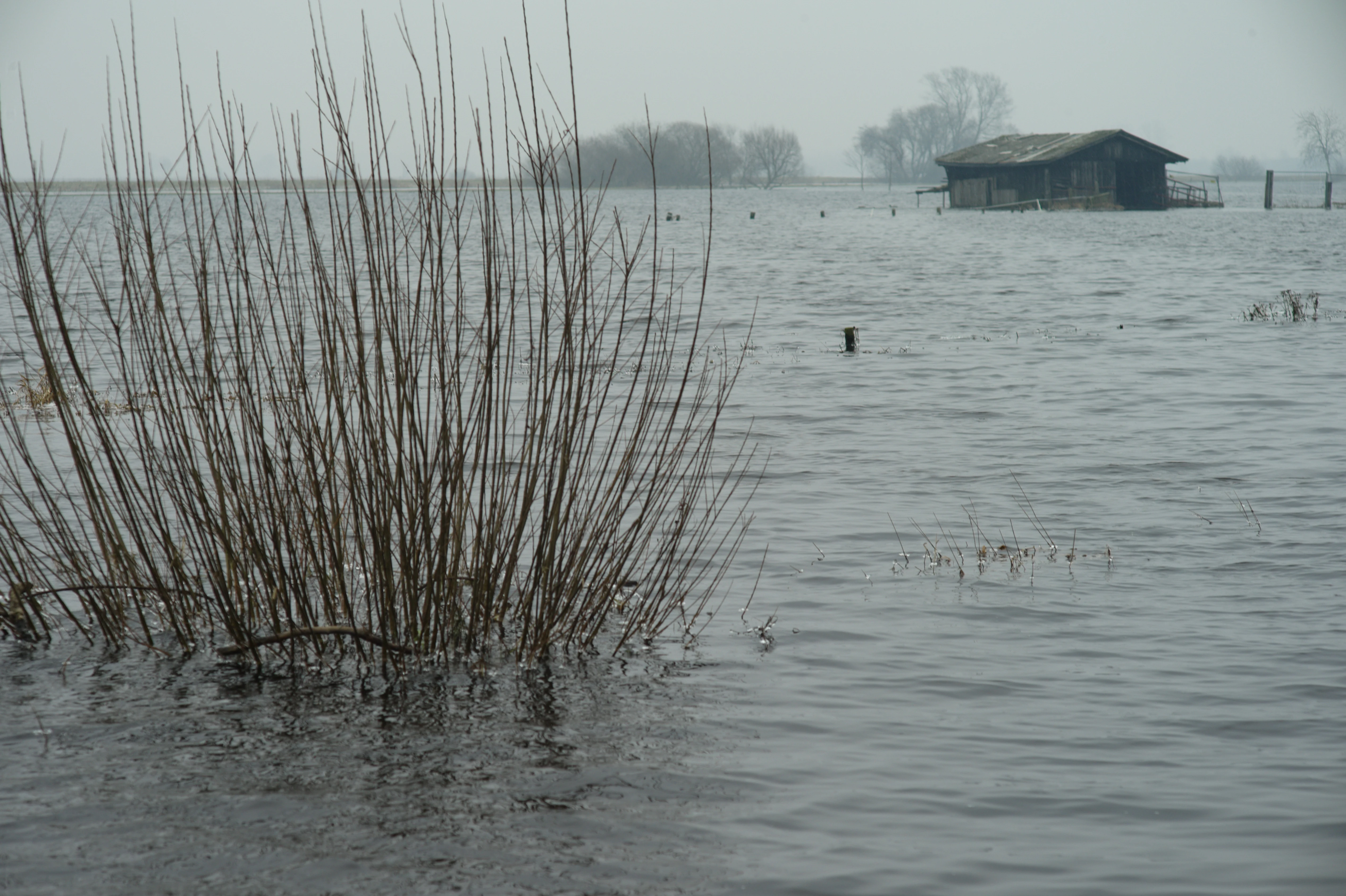
A flooded meadow in winter with a small wooden hut visible in the distance and a cluster of bare willow branches in the foreground.
Winter flooding in the Borgfelder Wümmewiesen nature reserve.

Borgfelder Wümmewiesen ecosystems, habitats, and plant life

The ecological identity of Borgfelder Wümmewiesen is closely tied to its character as an extensive wet grassland under regular flood influence. The reserve combines cultural landscape elements with semi-natural and naturally developing floodplain habitats, producing a high diversity of wetland vegetation types within a relatively uniform elevation range. Although much of the area is open meadow, the plant communities are structurally varied and reflect subtle differences in moisture, flooding frequency, and land use.

Vegetation in the reserve includes extensive wet meadows and pastures, with characteristic plants such as marsh marigold, cuckoo flower, ragged robin, marsh lousewort, marsh ragwort, and buttercups thriving in damp conditions. Habitat heterogeneity is reinforced by the presence of small sedge communities, large sedge stands, tall herb fringes, reedbeds, and flood-tolerant grassland. Along the margins and near former channels, more dynamic vegetation is establishing itself as parts of the area are left to develop without active management, reflecting the natural successional tendencies of an undisturbed floodplain.

Water is a constant presence across the reserve, not only through the Wümme and its north arm, but through dozens of ditches and small ponds. The artificially created ponds, established since the late 1980s, have added standing-water habitats that support characteristic wetland plant communities and increase overall habitat diversity. The combination of flowing channels, seasonal flooding, ditches, and permanent small water bodies produces a multi-layered hydrological system that sustains a wide range of wetland ecological niches within the reserve.

Borgfelder Wümmewiesen wildlife and species highlights

Borgfelder Wümmewiesen is nationally important for its birdlife, especially for species that depend on open wet grassland and undisturbed floodplain conditions. The reserve is recognized as a key breeding area for meadow birds (Wiesenvögel), including lapwing, corncrake, Eurasian curlew, black-tailed godwit, common redshank, snipe, and spotted crake. Its breeding population of rails (Rallen) is considered of nationwide significance in Germany, making the reserve a focal point for conservation of this often-overlooked group of wetland birds.

Beyond the breeding season, the reserve plays a substantial role as a staging and wintering area for migratory waterfowl. During the winter months, large numbers of ducks, geese, and swans use the flooded meadows and open water as resting and feeding habitat, taking advantage of the seasonal inundation that produces extensive shallow-water conditions across the area. This dual role as a breeding site for ground-nesting waders and a winter refuge for migratory waterfowl gives the reserve strong seasonal ecological importance.

Wetland invertebrates and amphibians also benefit from the dense network of small water bodies created since the late 1980s, which provide breeding and foraging habitat for frogs, newts, and a wide range of dragonflies. The combination of intact meadow vegetation, structural diversity of ditches and ponds, and minimal tree cover produces favorable conditions for species that thrive in open, sun-exposed, water-rich landscapes.

Borgfelder Wümmewiesen conservation status and protection priorities

From a conservation perspective, Borgfelder Wümmewiesen is a focal area for the protection of northern German floodplain ecosystems and their associated bird communities. Its large, contiguous area of regularly flooded wet grassland is rare in the densely settled Bremen region, making it disproportionately important for species that require extensive, undisturbed open habitats. The reserve's national significance for rail populations and its role as a major breeding area for meadow birds elevate it from a local green space to a regionally and nationally relevant conservation site.

The protection framework is layered: the site is a national nature reserve (Naturschutzgebiet), almost entirely overlaps with an EU Bird Protection Area (Vogelschutzgebiet) under the Birds Directive, and partly falls within an FFH site under the Habitats Directive. This multi-layered designation reflects both its ecological value and its role within the European Natura 2000 network. The reserve is managed under a comprehensive ordinance, most recently revised in 2015, which consolidated legal protection and incorporated additional floodplain area to strengthen ecological coherence.

Conservation management is delivered through a partnership model that combines municipal oversight with foundation-led practical work. The Stiftung NordWest Natur, in cooperation with WWF Germany, has coordinated habitat management since June 2006, focusing on maintaining open meadow conditions, sustaining breeding habitat for ground-nesting birds, and supporting natural floodplain dynamics in areas no longer used for agriculture. Combined with the historical hydrological reshaping of the area (including the creation of numerous small ponds since the late 1980s), this management approach aims to balance traditional land use, natural floodplain processes, and habitat creation for amphibians, dragonflies, and wetland vegetation.

Borgfelder Wümmewiesen cultural meaning and human context

Borgfelder Wümmewiesen reflects a long tradition of land use in the Wümme floodplain, where wet meadows and pastures have historically supported small-scale agricultural practices such as extensive grazing and hay-making. Even today, portions of the reserve remain part of a working cultural landscape, with riverside meadows still shaped by these older land-use patterns, while other sections are deliberately allowed to revert to a more natural floodplain state.

This coexistence of cultural and natural landscape elements gives the reserve a layered human context: it is simultaneously a product of centuries of floodplain farming and a modern symbol of ecological restoration and rewilding within a city-state. Public engagement is encouraged through a network of paved paths with interpretive panels and an observation tower at the Hollerdeich on the southern edge, allowing residents and visitors to connect with both the landscape's ecological and its rural heritage. The presence of these visitor facilities, alongside regulated non-motorized water sports on the Wümme, shows how the reserve integrates its conservation role with the everyday life of Bremen's surrounding neighborhoods.

Top sights and standout views in Borgfelder Wümmewiesen

Borgfelder Wümmewiesen stands out as Bremen's largest and second-largest state-level nature reserve, a 688-hectare open wet-meadow floodplain that is nationally important for breeding meadow birds and rails and serves as a major wintering site for ducks, geese, and swans.

The reserve's combination of nearly treeless wet grassland, regularly flooded meadows, dense ditch networks, and small created ponds produces a high-diversity wetland habitat within the densely populated Bremen region. Its multi-layered protection as a national nature reserve, EU Bird Protection Area, and partial FFH site, combined with modern foundation-led management and a fully revised 2015 ordinance, reinforces its status as one of the most significant floodplain conservation areas in northwestern Germany.

Best time to visit Borgfelder Wümmewiesen

The most distinctive seasonal character of Borgfelder Wümmewiesen comes in winter, when the meadows are regularly flooded and the area hosts large numbers of resting and wintering waterfowl such as ducks, geese, and swans. Wet, muddy conditions are typical, and the open landscape takes on a stark, expansive quality that emphasizes its floodplain origins.

Spring and early summer offer very different impressions, when receding water levels reveal damp grassland that supports breeding meadow birds, including lapwings, snipe, and curlews. Warmer months also bring more active amphibian and dragonfly life around the many small ponds created since the late 1980s. Across all seasons, the open, mostly treeless character of the meadows means that weather and flood conditions shape the visitor experience far more than vegetation changes do, so any visit should expect the landscape to feel intimately tied to the current state of the Wümme and its floodwaters.


Monthly climate preview

Long-term representative point measurements for temperature and precipitation rhythms

Borgfelder Wümmewiesen Climate Normals and Annual Weather by Month

Borgfelder Wümmewiesen records measured mean monthly temperatures ranging from near freezing to warm summer maximums alongside steady daily precipitation averages. Detailed monthly breakdowns provide deeper insight into long-term climate patterns across the protected landscape.
Annual mean9 °C
1 °C18 °C
Jan
Feb
Mar
Apr
May13°
Jun16°
Jul18°
Aug18°
Sep14°
Oct10°
Nov
Dec
Warmest month
July

18 °C

Coolest month
January

1 °C

Wettest month
July

2.5 mm/day

Driest month
April

1.4 mm/day

Park location guide

Geography guide, regional context, and park location map for Borgfelder Wümmewiesen

Borgfelder Wümmewiesen park geography, regions, and map view in Germany

Understand where Borgfelder Wümmewiesen sits in Germany through a broader geographic reading of the surrounding landscape, nearby location context, and its mapped position within the national park landscape.

How Borgfelder Wümmewiesen fits into Germany

Germany is a federal republic in Western and Central Europe with a population of over 83 million across sixteen constituent states. It is Europe's largest economy by nominal GDP and a major global exporter and importer. The capital is Berlin, and the country borders Denmark, Poland, Czech Republic, Austria, Switzerland, France, Luxembourg, Belgium, and the Netherlands.

Wider geography shaping Borgfelder Wümmewiesen in Germany

Germany is located in Western and Central Europe, spanning 357,022 km². It borders Denmark to the north, Poland and the Czech Republic to the east, Austria and Switzerland to the south, and France, Luxembourg, Belgium, and the Netherlands to the west. The country has coastlines on the Baltic Sea and North Sea to the north, with the Alps located in the southern region.

Map view of Borgfelder Wümmewiesen

Use this park location map to pinpoint Borgfelder Wümmewiesen in Germany, understand its exact geographic position, and read its mapped placement within the surrounding landscape more clearly.

Pigeon | © OpenStreetMap contributors

Location context for Borgfelder Wümmewiesen

Bremen
Recorded earthquake history

View the Historical Earthquake Records for Borgfelder Wümmewiesen

Access the complete MoriAtlas catalogue of recorded seismic events identified near the Borgfelder Wümmewiesen nature reserve. This resource provides a clear, data-driven perspective on regional earthquake history, linking specific seismic events to their approximate location within the Bremen floodplain landscape.

Borgfelder Wümmewiesen Earthquake History

Catalogued events

3 events

Strongest magnitude

Magnitude 4.5

Most recent event

Jul 15, 2005

This history includes earthquakes recorded inside the park or within 50 km of its borders

Visual reference collection showcasing open wet grasslands, meandering river channels, and seasonal floodplain terrain.

Borgfelder Wümmewiesen Landscape Photos, Scenery, and Protected Wetland Habitat Views

Visual exploration reveals the open terrain, low elevation plains, and seasonal flood dynamics that define the protected landscape. Detailed photography provides clear insight into the wetland habitats, drainage networks, and semi-natural character preserved across the reserve.

A wide, gravel walking path leads into the distance, with green meadows on the left and trees along a river bank on the right under a blue, partly cloudy sky.

A horizontal landscape photograph of the Borgfelder Wümmewiesen nature reserve, showing a calm stream in the foreground reflecting the bright blue sky and clouds, bordered by flat, vibrant green grassy meadows stretching to the horizon.

A flooded meadow in winter with a small wooden hut visible in the distance and a cluster of bare willow branches in the foreground.

Park atlas

Compare regional river valleys and lowland wetland reserves across northern Germany.

Parks Near Borgfelder Wümmewiesen and Surrounding Protected Landscapes

Browsing parks near Borgfelder Wümmewiesen reveals connected floodplain ecosystems and wetland reserves across the surrounding region. Comparing adjacent protected landscapes provides deeper context into regional lowland conservation geography and river valley habitats.
Nature reserveBremen
Park boundaries overlap#1 closest

Northwest

Untere Wümme Nature Reserve: Riverine Biodiversity and Protected Tidal Landscapes in Bremen

Protected floodplain geography and tidal river habitats.

This nature reserve protects the meandering lower course of the Wümme river, showcasing one of northern Germany's few freshwater tidal systems. Spanning reedbeds, willow forests, and open mudflats, the reserve forms a vital corridor for migratory fish and waterfowl, reflecting a complex mosaic of protected riverine ecosystems and historic meadow landscapes.

Area
1.485 km²
Established
1991
Relief
Lowland
Climate
Temperate
A soft, painterly watercolor illustration depicting a winding river through a flat green meadow with rolling hills in the background.
Nature reserveBremen
1.4 km away#2 closest

West

Hollerland Nature Reserve: A Protected Cultural Landscape and Wetland in Bremen

Historic marshland terrain with unique saline spring ecosystems

Hollerland is a 293-hectare nature reserve in Bremen, Germany, notable for its well-preserved cultural landscape of wet grasslands and an intricate medieval ditch network. This protected area serves as a critical breeding ground for meadow birds and hosts an ecologically significant inland saline spring, providing a rare habitat for brackish-adapted plant communities deep within the regional landscape.

Area
2.93 km²
Established
1985
IUCN
IV
Relief
Lowland
Nature reserveBremen
3.3 km away#3 closest

West

Kuhgrabensee Nature Reserve: Mapped Geography and Protected Areas in Bremen

An ecologically vital lake and bird sanctuary in Northwest Germany

Kuhgrabensee serves as a prime example of landscape restoration within Bremen, featuring a groundwater-fed lake with notable saline influences. This protected area supports a diverse array of pioneer plants and wildlife across its reed-lined shores and shallow-water habitats, providing a quiet corridor for ecological observation and study in the heart of the local landscape.

Area
0.296 km²
Established
1987
Relief
Lowland
Climate
Temperate
A watercolor painting showing a serene landscape with calm water, small islands of trees, and rolling hills in the background.
Nature reserveBremen
About 4.5 km away#4 closest

West

Am Stadtwaldsee (Uni-Wildnis) Nature Reserve: Geographic Atlas and Park Map Context

Protected secondary habitat landscape in Bremen, Germany

Located in Bremen, the Am Stadtwaldsee (Uni-Wildnis) nature reserve offers a compelling study of secondary ecological succession. The area features a dense concentration of ponds and wooded ground shaped by historical sand mining. Explore the mapped boundaries of this eleven-hectare refuge to understand its role in urban biodiversity and regional landscape conservation.

Area
0.114 km²
Established
1991
IUCN
IV
Nature reserveLandkreis Osterholz
About 5.9 km away#5 closest

North

Westliche Hälfte des Langen Moores Nature Reserve in Landkreis Osterholz

A protected mosaic of highmoor peatland geography

Examine the distinct ecological features of Westliche Hälfte des Langen Moores, a protected nature reserve in Landkreis Osterholz. This site offers a compact look at highmoor regeneration and the diverse plant communities found within the historic Teufelsmoor cultural landscape of northern Germany.

Area
0.11 km²
Established
1984
IUCN
IV
Watercolor painting of a wide, rolling landscape with green trees, golden fields, and soft hills in the background.
Protected areaGermany
6.4 km away#6 closest

South

Krietes Wald (Im Holze) Protected Area: Landscape and Geographic Atlas Summary

A critical urban forest node in the Bremen region of Germany.

Krietes Wald (Im Holze) serves as a significant nature reserve characterized by its mature beech and oak-hornbeam woodland. Spanning a narrow, protected corridor in eastern Bremen, the site provides dense habitat value within an industrial landscape. It stands as a regional reference for saproxylic insect conservation and structural forest development within the federal republic of Germany.

Area
0.083 km²
Established
2015
Relief
Lowland
Climate
Temperate
Protected landscapeBremen
About 8.2 km away#7 closest

South

Mahndorfer Düne: A Protected Inland Dune Landscape in the City of Bremen

Geological remnants and ecological layering in Northwest Germany.

Mahndorfer Düne is a distinct protected landscape in Bremen, Germany, functioning as one of the final surviving inland dune relics from the Ice Age. The 2.7 hectare area maps a layered transition of sandy soil, dry heathland, and birch-oak woodland, offering an important look at regional post-glacial geology and conservation within a dense urban setting.

Area
0.027 km²
Established
1985
Relief
Lowland
Climate
Temperate
Nature reserveBremen
About 9.4 km away#8 closest

Southwest

Vogelschutzgebiet Arsten-Habenhausen: Mapping the Protected Weser Floodplain Habitat

A historic urban nature reserve located in Bremen

Located in the Habenhausen district of Bremen, Vogelschutzgebiet Arsten-Habenhausen is a significant protected area focused on river floodplain maintenance. The site provides a concentrated view of floodplain woodland and reedbed vegetation, illustrating how small, long-established nature reserves contribute to the regional geography of the Weser river corridor in Germany.

Area
0.01 km²
Established
1950
IUCN
IV
Relief
Lowland

Common questions about visiting, size, designation, and location context for Borgfelder Wümmewiesen

Borgfelder Wümmewiesen FAQs for park facts, access, geography, and protected area context

Find quick answers about Borgfelder Wümmewiesen, including protected-area facts, park geography, trail and visitor context, and how the park fits into its surrounding country and regional landscape.
MoriAtlas Explorer

Continue Your Protected Areas Search Across the Global Atlas

Deepen your exploration by continuing the structured search for national parks and protected areas worldwide. Utilize the comprehensive filtering capabilities to compare different conservation landscapes and refine your understanding of global park geography. Discover more about the distribution and characteristics of protected natural areas.

Global natural geography