

Mori Atlas logo
Nature reserveBriesensee und Klingeberg

Examining the glacial moraine terrain, seepage springs, and old-growth pine ecosystems of this protected German area

Briesensee und Klingeberg Nature Reserve: A Detailed Geographic Atlas of Brandenburg Protected Landscapes

(Naturschutzgebiet Briesensee und Klingeberg)

Briesensee und Klingeberg functions as a critical nature reserve within the state of Brandenburg, Germany, representing a compact mosaic of glacial landforms. The area encompasses the Briesensee lake and significant portions of the Tornower See, where shifting geological substrates support diverse aquatic and forest habitats. Through this detailed atlas record, examine the integration of ancient autochthonous pine stands, sensitive mire woodlands, and the historic Klingespring seepage system as they define this unique site within the broader Brandenburg lake landscape.

nature reserveBrandenburglake landscapeglacial morainepine forestsprings

Briesensee und Klingeberg

Nature reserve

Park overview

Structured park overview, official facts, and landscape profile for Briesensee und Klingeberg

Briesensee und Klingeberg park facts, protected area profile, and essential visitor context

Review the core facts for Briesensee und Klingeberg, including designation, size, terrain, visitor scale, habitats, and operating context in one park-focused overview.

About Briesensee und Klingeberg

Briesensee und Klingeberg is a nature reserve that captures a particularly dense example of the glacial landscape typical of southern Brandenburg. It protects a small but ecologically rich ensemble of lakes, moraine slopes, pine forests, springs, and mire communities in the Dahme-Spreewald district near Teupitz. The reserve integrates two lakes (Briesensee and the southern portion of Tornower See) with the surrounding terrain that connects them, allowing for the protection of both aquatic and terrestrial habitat types within a compact footprint.

Despite its modest size, the area is ecologically significant because it preserves habitat mosaics that are largely absent from surrounding intensively used land. The reserve's beech-free, near-natural pine mixed forests reflect the sandy, glacial soils of the region, while the steep moraine slopes along Tornower See support specialized communities of ferns and wintergreen species. At the base of these slopes, seepage zones, fens, and alder swamp form the transition between forest and open water. The reserve is anchored by the Briesensee, which gives the protected area part of its name, and by the forested moraine rising above Tornower See, which forms the landscape around the historic Klingespring.

Culturally, the area also carries an early protection history. The Klingespring at the foot of one slope was already documented on a 1936 map of the Staakow forestry office and is regarded as one of the oldest natural monuments of the region; its protection is associated with the botanist Adolf Strauss (1904–1986), after whom a memorial stone was erected by the local NABU chapter along a trail connecting Tornower See with Briesensee. After 1990, camping sites from the former GDR era that had damaged local flora and fauna were fully dismantled, allowing ecological recovery. Today, the reserve is recognized both as a regional conservation site and as part of the broader European Natura 2000 framework, which underlines its cross-border significance for habitat conservation.

Quick facts and research context for Briesensee und Klingeberg

Briesensee und Klingeberg is a 79.9 hectare nature reserve in Brandenburg, Germany, classified as a Habitat/Species Management Area under IUCN Category IV. It lies within the municipal area of Teupitz, in the Dahme-Spreewald district, and was formally designated on 1 July 2002. The reserve includes Briesensee lake, parts of Tornower See, and surrounding moraine slopes, and is part of the European Natura 2000 ecological network.

Protection and recognition

Documented conservation recognition and official protected area records

Briesensee und Klingeberg Protection Status and Natura 2000 Designation Data

Briesensee und Klingeberg holds verified Natura 2000 recognition within official protected area databases. Structured administrative records provide transparent access to conservation frameworks and designation history.
Park context

Deeper park guide and search-rich context for Briesensee und Klingeberg

Briesensee und Klingeberg history, landscape, wildlife, and travel context

Explore Briesensee und Klingeberg through its history, landscape character, ecosystems, wildlife, conservation priorities, cultural context, and seasonal travel timing in a structured park guide built for atlas discovery and search intent.

Why Briesensee und Klingeberg stands out

The reserve is best known for its combination of glacial lakes, ancient autochthonous pine stands on moraine slopes, and the historically documented seepage spring called Klingespring. The mix of spring-fed aquatic habitats, old near-natural pine mixed forests, alder mires, and rich fern and wintergreen communities makes it a textbook example of a small Brandenburg glacial landscape reserve. It also stands out for the genetic confirmation of pines over 220 years old, found through research by the Leibniz Centre for Agricultural Landscape Research in Müncheberg.
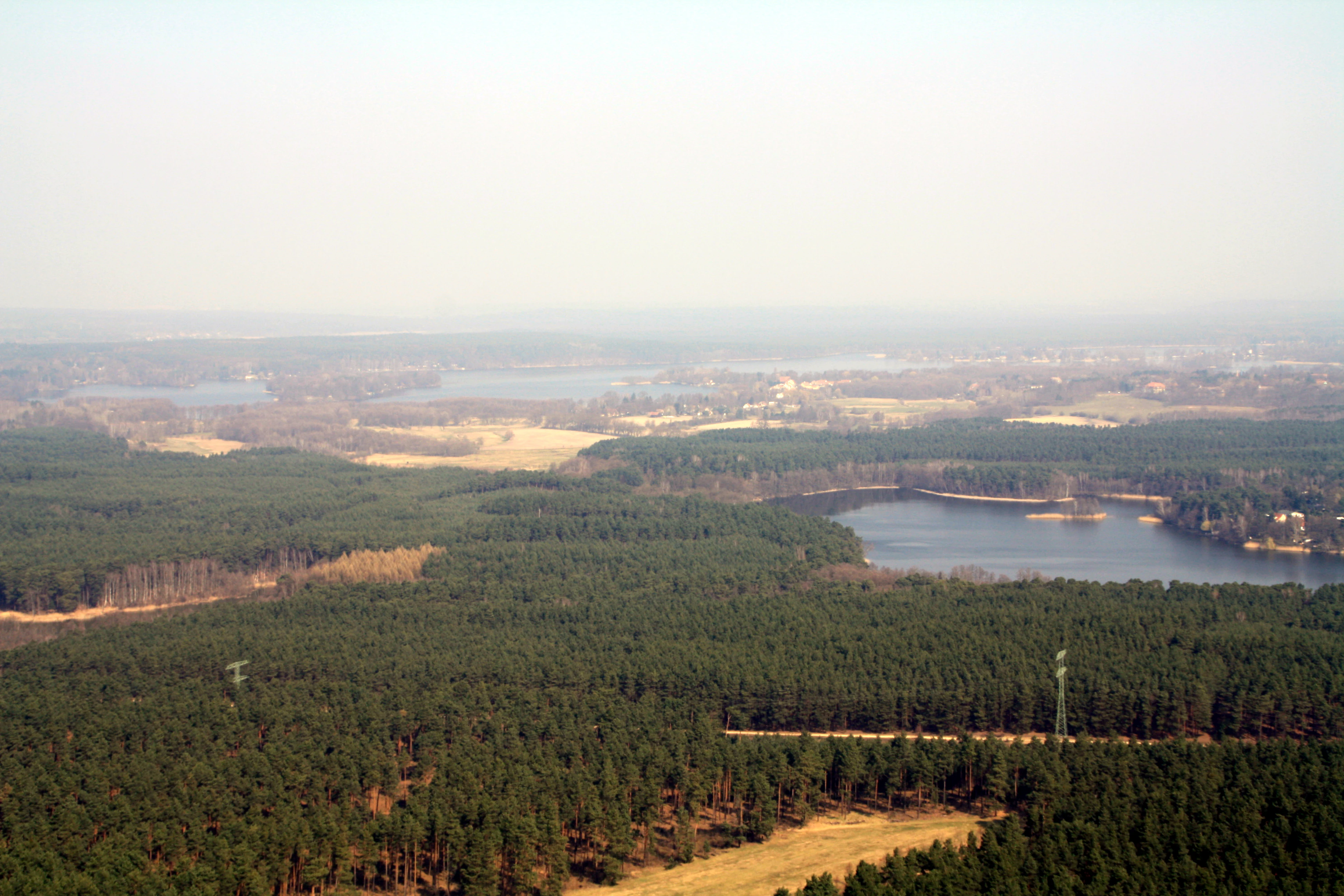
Aerial photograph showing a vast pine forest with a lake and sandy clearings under a hazy sky.
Aerial view of the Briesensee und Klingeberg Nature Reserve showing dense pine forests and lakes in Brandenburg.

Briesensee und Klingeberg history and protected-area timeline

The historical roots of Briesensee und Klingeberg's protection go back to the first half of the twentieth century, when the seepage spring known as Klingespring, located on a slope facing the southern shore of Tornower See, was already recorded on a 1936 map of the Staakow forestry office. This spring was regarded as one of the oldest natural monuments in the region and was placed under protection through the efforts of the botanist Adolf Strauss (1904–1986).

During the East German (GDR) era, the area experienced significant pressure from recreational use, including campsites that negatively affected local flora and fauna. Following German reunification, these camping sites were fully dismantled after 1990, removing a major source of disturbance and allowing natural processes to recover. The broader landscape continued to undergo changes as traditional uses like small-scale farmer woodland and litter harvesting (Streunutzung), which once helped maintain certain open forest communities, declined; without these uses, some wintergreen and clubmoss species have retreated over recent decades.

The modern, formal protection of Briesensee und Klingeberg dates to 1 July 2002, when the area was officially designated as a Naturschutzgebiet under Brandenburg law. It was subsequently incorporated into the European Natura 2000 network, recognizing its broader significance beyond regional conservation priorities. The site's identity today blends its early-twentieth-century natural monument history with a more recent, formally structured statutory protection regime.

Briesensee und Klingeberg landscape and geographic character

The landscape of Briesensee und Klingeberg is shaped by the glacial history of southern Brandenburg. The reserve centers on the Briesensee and the southern and southwestern shores of the nearby Tornower See, two lakes embedded in a terrain of moraine ridges, slopes, and basins. Steep moraine slopes rise from the southern edge of Tornower See, where the substrate transitions from sandy, water-permeable layers above to finer, water-retaining layers below. This geological structure gives rise to the seepage springs that define the protected area.

Along the lakes, gentle boggy margins and shallow bays transition into alder swamp, reed belts, and small patches of wet meadow. The upland portions of the reserve carry near-natural pine mixed forests on sandy soils, with the characteristic open character of Brandenburg's dry, acidic woodland habitats. In places, the slopes support relict pine stands that have grown here continuously, including trees well over two centuries old.

The defining feature of the reserve's terrain is the moraine slope above the southern shore of Tornower See, where the Klingespring emerges. Water that infiltrates the sandy upper slope travels downward and reappears at a less permeable layer, generating a small, persistent spring. The flow of this spring slowly erodes sand, which is deposited as an alluvial fan in the lake below, illustrating an ongoing, fine-scale process of glacial landscape evolution.
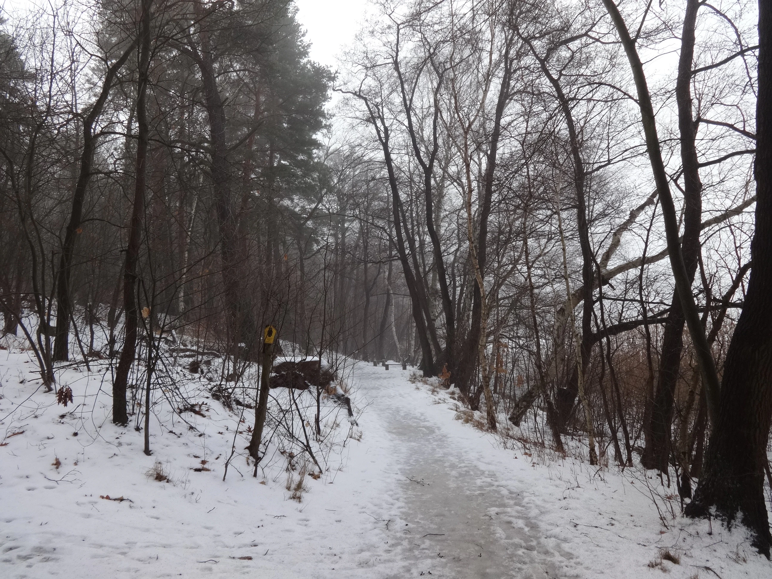
A snow-covered path winding through a winter forest with bare deciduous trees and some evergreens, with a yellow trail marker visible on the left side.
A snow-covered forest path at the southeastern entrance to Briesensee und Klingeberg nature reserve in winter, with bare deciduous trees and a yellow trail marker.

Briesensee und Klingeberg ecosystems, habitats, and plant life

The nature of Briesensee und Klingeberg is defined by an unusually rich concentration of habitat types for such a compact area. Its lake environments include open water, reed communities, and floating as well as emergent aquatic plant zones, and they transition through alder swamp and mire woodland into upland pine forests. The result is a tightly woven ecological mosaic of aquatic, semi-aquatic, and terrestrial habitats.

The spring habitats themselves are a particular focus of the reserve's conservation aims. The Klingespring and similar seepage areas support characteristic spring flora such as marsh forget-me-not, water moss (Fontinalis), true watercress, brooklime, and the spotted polypody fern above the slope. These specialized plants are considered indicators of clean, undisturbed spring water.

The woodland communities reflect the sandy, acidic soils typical of the glacial outwash and moraine landscapes of Brandenburg. Near-natural pine mixed forests dominate, with the reserve protecting some of the oldest autochthonous pine stands in the region. On the moraine slopes, communities of ferns and wintergreens, including the rare umbellate wintergreen, give the woodlands a distinctive herb-layer character. Small areas of clay and loam pits, wet meadows, and bog woodland further contribute to habitat diversity within the reserve's boundaries.
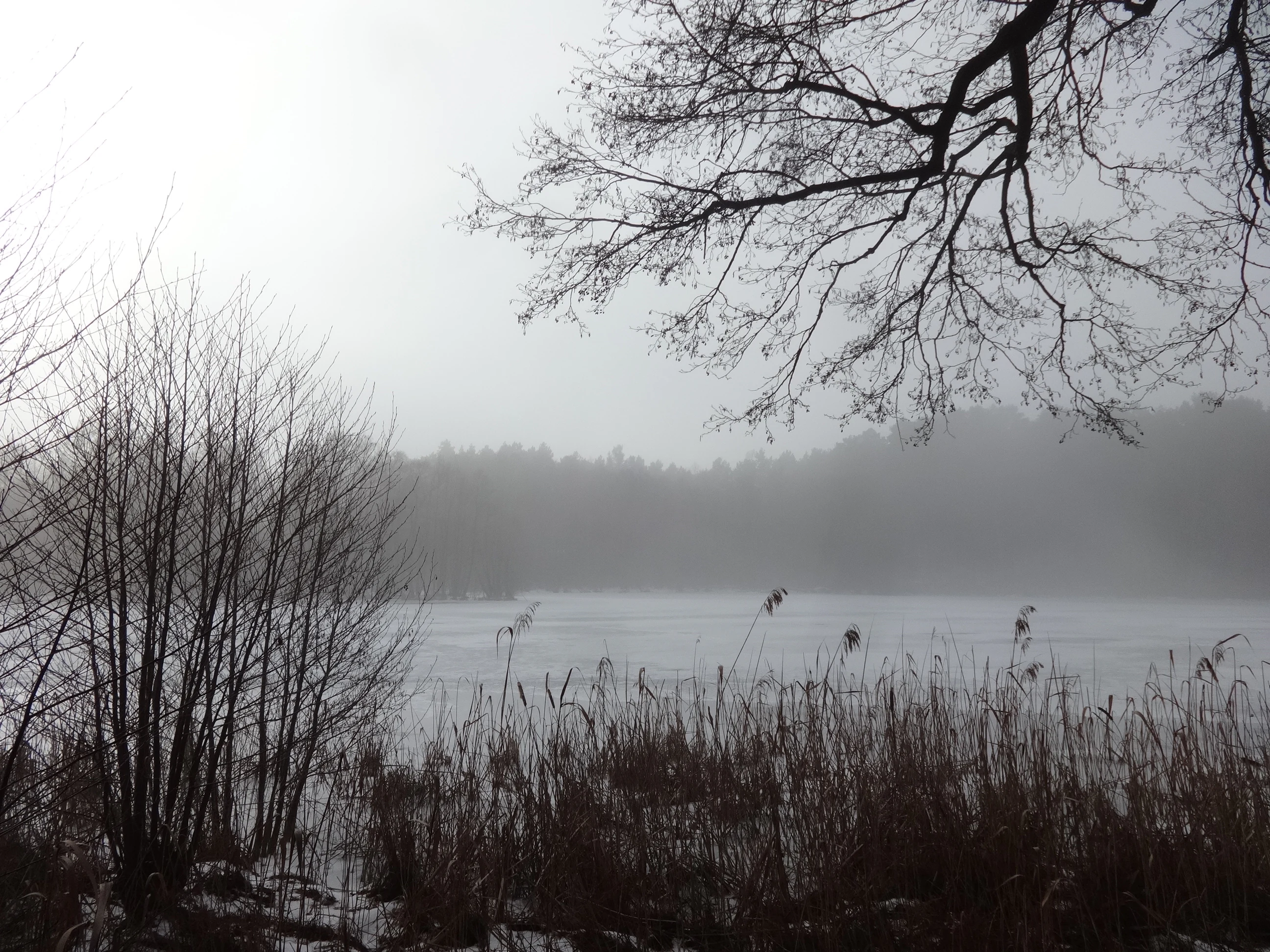
A foggy lake scene with bare deciduous trees and reeds in the foreground, with a forested shoreline visible through the mist in the background
Misty winter view of Briesensee lake with bare trees and reeds along the shore in Teupitz, Brandenburg

Briesensee und Klingeberg wildlife and species highlights

The wildlife of Briesensee und Klingeberg reflects the diversity of its habitats, with several species of conservation interest documented in the reserve. Birdlife is particularly notable, with the area providing habitat for raptors, including some species considered severely endangered. Among the characteristic birds recorded are the common kingfisher, black woodpecker, green woodpecker, and several reedbed-associated songbirds: the Savi's warbler (Rohrschwirl) and the great reed warbler (Drosselrohrsänger).

Aquatic and semi-aquatic fauna include the common frog and moor frog, both of which rely on the wet transition zones around the lakes and in the alder swamp areas. The European otter is also documented in the area, depending on the connectivity of wetlands and the availability of fish prey in Briesensee and Tornower See.

The reserve's spring habitats and old pine forests support specialized invertebrate communities, including insects and mollusks tied to clean, undisturbed seepage zones and old-growth pine stands. These less conspicuous species are an important reason the area is protected under the EU Habitats Directive framework.

Briesensee und Klingeberg conservation status and protection priorities

Briesensee und Klingeberg's conservation value extends well beyond its modest size. The reserve was formally designated to protect a tightly linked set of habitat types that are difficult to maintain in the surrounding intensively used agricultural and forested landscape. Its protection aims explicitly cover spring habitats, flowing and standing waters with their aquatic plant and reed communities, near-natural pine mixed forests, old autochthonous pine stands, alder swamp, mire woodland, and small relict wet meadows. The site is also designated to safeguard species specifically tied to these habitats, including invertebrates and mollusks of spring and aquatic systems and several rare raptor species.

The site is integrated into the European Natura 2000 network, placing it within the framework of EU-wide habitat protection. Internationally, the protected area is recorded under IUCN Category IV as a Habitat/Species Management Area, reflecting a management-oriented approach that combines protection with active conservation of characteristic species and habitat structure.

The reserve also illustrates the long-term challenges of maintaining small habitat reserves. The decline of traditional practices like small-scale farmer woodland management and litter harvesting has reduced the extent of wintergreen and clubmoss communities in recent decades, while the water quality of Briesensee is documented as poor and affects the connected Briesenseegraben. Active management, ongoing monitoring, and the removal of past disturbances (such as the dismantling of GDR-era campsites after 1990) continue to be part of the conservation approach for the area.

Briesensee und Klingeberg cultural meaning and human context

The cultural context of Briesensee und Klingeberg is closely tied to early nature conservation in Brandenburg. The protection of the Klingespring was pursued by the botanist Adolf Strauss (1904–1986), whose work helped establish the spring as one of the region's oldest documented natural monuments. The local NABU chapter Dahmeland later honored Strauss with a memorial stone along a hiking trail linking Tornower See with Briesensee, underlining the area's continuing place in the regional culture of nature appreciation.

The landscape also carries traces of twentieth-century social history. During the GDR era, the area was used for recreational camping, which significantly affected local flora and fauna. After 1990, these campsites were fully dismantled, marking an important turning point in the area's ecological and cultural trajectory. Today, the reserve is valued both as a place of quiet nature-based recreation and as a reference point for understanding how small Brandenburg landscapes have moved from informal protection through practical conservation into modern, statutory safeguarding.

Top sights and standout views in Briesensee und Klingeberg

A particularly notable feature of the reserve is the contrast between open glacial lakes and forested moraine slopes, with rare old autochthonous pines over 220 years old confirmed through genetic research at the Leibniz Centre for Agricultural Landscape Research in Müncheberg. The Klingespring, documented since 1936, adds a layer of historical natural monument status to the site's identity, while Natura 2000 recognition confirms its place in European-scale habitat conservation. Together, the lakes, spring, pine forests, and mire communities make Briesensee und Klingeberg a compact but well-rounded showcase of Brandenburg's ice-age landscapes.

Best time to visit Briesensee und Klingeberg

Like much of Brandenburg, Briesensee und Klingeberg is best experienced during the warmer months when the lakes, reed zones, and forest understory are most accessible. Late spring and early summer bring active birdlife along the reed belts and shoreline, while summer offers the fullest expression of the aquatic and wetland vegetation around Briesensee and Tornower See. Autumn highlights the colors of the pine mixed forests and the fern and wintergreen communities on the moraine slopes. Winters are quiet, with snow occasionally accentuating the open character of the pine stands and the slopes above the Klingespring. Visitors should plan around the small size of the reserve and respect its protected status when exploring the area on foot.

Monthly climate preview

Long-term representative monthly temperature ranges and precipitation averages in Brandenburg

Briesensee und Klingeberg Climate Normals, Annual Temperature and Precipitation Patterns

Briesensee und Klingeberg records measured monthly temperature and precipitation normals derived from long-term satellite coordinate sampling across Brandenburg. Examining the complete twelve-month meteorological profile reveals detailed seasonal variations in average temperatures and daily moisture accumulation.
Annual mean10 °C
-1 °C21 °C
Jan-1°
Feb
Mar
Apr
May14°
Jun18°
Jul21°
Aug20°
Sep15°
Oct
Nov
Dec
Warmest month
July

20.6 °C

Coolest month
January

-0.8 °C

Wettest month
July

2.5 mm/day

Driest month
April

1.1 mm/day

Park location guide

Geography guide, regional context, and park location map for Briesensee und Klingeberg

Briesensee und Klingeberg park geography, regions, and map view in Germany

Understand where Briesensee und Klingeberg sits in Germany through a broader geographic reading of the surrounding landscape, nearby location context, and its mapped position within the national park landscape.

How Briesensee und Klingeberg fits into Germany

Germany is a federal republic in Western and Central Europe with a population of over 83 million across sixteen constituent states. It is Europe's largest economy by nominal GDP and a major global exporter and importer. The capital is Berlin, and the country borders Denmark, Poland, Czech Republic, Austria, Switzerland, France, Luxembourg, Belgium, and the Netherlands.

Wider geography shaping Briesensee und Klingeberg in Germany

Germany is located in Western and Central Europe, spanning 357,022 km². It borders Denmark to the north, Poland and the Czech Republic to the east, Austria and Switzerland to the south, and France, Luxembourg, Belgium, and the Netherlands to the west. The country has coastlines on the Baltic Sea and North Sea to the north, with the Alps located in the southern region.

Map view of Briesensee und Klingeberg

Use this park location map to pinpoint Briesensee und Klingeberg in Germany, understand its exact geographic position, and read its mapped placement within the surrounding landscape more clearly.

Pigeon | © OpenStreetMap contributors

Location context for Briesensee und Klingeberg

Brandenburg

Explore protected area imagery highlighting ancient pine forests, moraine slopes, and glacial lake habitats.

Briesensee und Klingeberg Landscape Photos and Glacial Scenery Visual Guide

Visual documentation captures the glacial lakes, seepage springs, and old-growth pine forests defining the protected terrain of Briesensee und Klingeberg. Examining field photography reveals the characteristic topography, wetland margins, and ecological structure of this Brandenburg nature reserve.

Aerial photograph showing a vast pine forest with a lake and sandy clearings under a hazy sky.

A small stream flows through a misty winter forest with a fallen log crossing the water and snow on the ground.

A snow-covered path winding through a winter forest with bare deciduous trees and some evergreens, with a yellow trail marker visible on the left side.

A foggy lake scene with bare deciduous trees and reeds in the foreground, with a forested shoreline visible through the mist in the background

Park atlas

Compare adjacent glacial lakes, old-growth pine forests, and regional conservation reserves.

Other Parks Near Briesensee und Klingeberg and Surrounding Brandenburg Protected Areas

Continue exploring regional park geography by comparing Briesensee und Klingeberg with other protected natural areas across Brandenburg. Examining surrounding lacustrine terrain provides broader context for glacial moraine landscapes and local forest reserves.
Nature reserveBrandenburg
3.1 km away#1 closest

Northwest

Kleine und Mittelleber Nature Reserve: Brandenburg Wetland and Mire Landscape Mapping

Ecological terrain analysis of a protected post-glacial site

Kleine und Mittelleber is a significant nature reserve in Brandenburg that preserves a rare sequence of silted-up lake basins and active peat-forming bogs. The area provides a detailed window into the interplay of transitional mire systems, floating mat bogs, and pine-fringed woodlands. Through its status as a European FFH site, it serves as a vital case study for the conservation of wetland habitats and the restoration of natural hydrological processes in post-industrial forest landscapes.

Area
0.665 km²
Established
1995
Nature reserveBrandenburg
4 km away#2 closest

Northeast

Naturschutzgebiet Löptener Fenne, Wustrickwiesen: Mapped Geography and Protected Landscapes

Glacial mire and wetland systems in Brandenburg, Germany

The Naturschutzgebiet Löptener Fenne, Wustrickwiesen nature reserve provides a critical look at terrestrialized mire landscapes. Beneath its surface lie deep layers of lake-derived mud, marking this site as a key reference for understanding glacial meltwater history in eastern Germany. Today, the area serves as a focal point for active peatland renaturation and habitat management within the Dahme-Spreewald district.

Area
2.18 km²
Established
1998
IUCN
IV
Relief
Lowland
Nature reserveBrandenburg
4.7 km away#3 closest

North

Töpchiner Seen Nature Reserve: Geographic Overview of Brandenburg Protected Landscapes

A glacial landscape mosaic of lakes, fens, and woodlands

Located in the Dahme-Spreewald district, Töpchiner Seen is a vital nature reserve showcasing deep peat deposits and diverse wetland vegetation. The protected area features a layered terrain, where open water connects to transition mires, calcareous meadows, and mature oak and pine forests, providing a stable habitat for specialized flora and fauna within the broader Brandenburg geography.

Area
3.75 km²
Established
1988
Nature reserveBrandenburg
8.6 km away#4 closest

Northeast

Stintgraben Nature Reserve: Protected Stream Landscapes in Southern Brandenburg

Ecological connectivity between glacial lakes and river corridors.

Located in the Dahme-Spreewald district, Stintgraben is a protected stream corridor defined by its lowland riparian habitats and position between the Klein Köriser See and the Dahme river. This nature reserve provides essential ecological continuity within the broader Dahme-Heideseen region, offering a clear example of how small-scale protected areas maintain the natural integrity of Germany's glacial lake districts.

Area
1.09 km²
Established
1995
IUCN
IV
Nature reserveBrandenburg
9.6 km away#5 closest

West

Schöbendorfer Busch Nature Reserve: Mapped Protected Geography in Brandenburg

Lowland deciduous forest and glacial valley landscape.

Schöbendorfer Busch provides a window into the natural heritage of the Baruther Urstromtal. This nature reserve protects over 800 hectares of forest and agricultural mosaic, serving as a primary habitat for rare saproxylic beetles and bats. Its terrain, defined by glacial meltwater deposits and wet alder swamp environments, offers a distinctive example of Brandenburg forest conservation.

Area
8.31 km²
Established
1978
IUCN
IV
Nature reserveBrandenburg
11 km away#6 closest

Northeast

Katzenberge Nature Reserve: An Atlas of Glacial Moraine Woodlands in Brandenburg Germany

Protected oak forest habitats within the Dahme-Spreewald landscape

Katzenberge offers a focused look at the conservation of mature deciduous forest environments on sandy moraine soils. As a designated nature reserve within the Brandenburg region, the area serves as a primary reference point for studying habitat continuity and the unique glacial terrain that defines the south-eastern lowlands near the Dahme river.

Area
1.44 km²
Established
2004
IUCN
IV
Relief
Upland
Nature reserveBrandenburg
About 13 km away#7 closest

Northeast

Streganzsee-Dahme Nature Reserve: Mapping Brandenburg Protected River Landscapes and Dunes

An ecological mosaic in the Dahme-Spreewald river corridor

Streganzsee-Dahme represents an intact Brandenburg riverine corridor characterized by sharply varied topography. The reserve encompasses water bodies, floodplain forests, fens, and dry sandland heaths. Its protected boundaries connect various biotopes, offering an essential look at the region's diverse lowland ecology and the structured geography of the local conservation network.

Area
4.36 km²
Established
1999
IUCN
IV
Relief
Lowland
Nature reserveBrandenburg
17 km away#8 closest

Northeast

Dolgensee Nature Reserve: Mapped Protected Landscapes and Wetland Geography in Brandenburg, Germany

Protected lake basin, reedbeds, and inland dune grassland

Located in the Brandenburg state of Germany, Dolgensee Nature Reserve offers a rare mosaic of wetland and dry grassland habitats. The site centers on a nutrient-rich lake basin featuring extensive reedbeds and alder swamp, which transitions into open inland dune ecosystems. This protected area represents a significant example of natural lake basin preservation within the larger Dahme-Heideseen landscape, providing a crucial habitat for various waterbird and aquatic wildlife species.

Area
3.085 km²
Established
1995
IUCN
IV
Relief
Lowland

Common questions about visiting, size, designation, and location context for Briesensee und Klingeberg

Briesensee und Klingeberg FAQs for park facts, access, geography, and protected area context

Find quick answers about Briesensee und Klingeberg, including protected-area facts, park geography, trail and visitor context, and how the park fits into its surrounding country and regional landscape.
MoriAtlas Explorer

Continue Your Protected Areas Search Across the Global Atlas

Deepen your exploration by continuing the structured search for national parks and protected areas worldwide. Utilize the comprehensive filtering capabilities to compare different conservation landscapes and refine your understanding of global park geography. Discover more about the distribution and characteristics of protected natural areas.

Global natural geography