
Mori Atlas logo
Nature reserveBruch von Brensbach

Mapping the carr woodland and wetland corridor of this Odenwald district nature reserve

Bruch von Brensbach: A Protected Nature Reserve in the Gersprenz Valley of Hesse, Germany

(Naturschutzgebiet Bruch von Brensbach)

Bruch von Brensbach serves as a vital ecological refuge within the Gersprenz valley of Hesse, preserving a compact mosaic of carr woodland, reed beds, and stream-fed marshes. Located in the Odenwaldkreis district, this nature reserve maintains a distinct wetland landscape that stands in contrast to the surrounding agricultural meadows and traditional orchards. The area offers a window into the historical lowland valley environment that once defined this region of central Germany.

wetlandnature reservecarr woodlandreed bedsGersprenz valleyOdenwaldkreis
A flat-design, stylized vector illustration of a lush mountain valley featuring a winding river, a cascading waterfall, and forested slopes under a soft-colored sky.

Bruch von Brensbach

Nature reserve

Park overview

Structured park overview, official facts, and landscape profile for Bruch von Brensbach

Bruch von Brensbach park facts, protected area profile, and essential visitor context

Review the core facts for Bruch von Brensbach, including designation, size, terrain, visitor scale, habitats, and operating context in one park-focused overview.

About Bruch von Brensbach

Bruch von Brensbach lies in the southern part of the German state of Hesse, within the Odenwaldkreis district and the municipal area of Brensbach. The reserve occupies a modest position in the broader Gersprenz river system, east of the main course of the Gersprenz and southwest of the village of Brensbach itself. The Bundesstraße 38 forms a boundary to the northeast, separating the wetland fragment from the road infrastructure and the surrounding villages.

At the heart of the reserve is a small stretch of carr woodland, a type of moist, seasonally flooded forest dominated by tree species adapted to waterlogged soils. This Bruchwald is interwoven with substantial stands of common reed, which give the wetland its characteristic dense, marsh-like character. The Kilsbach, a small stream that joins the Gersprenz just north of the protected area, flows through the reserve and provides the hydrological backbone that sustains these wet habitats.

Although the protected area is small, its surroundings give it a strongly contrasted setting. To the west and across much of the area, the landscape is dominated by agricultural land use, including managed grassland and cultivated fields. To the east, a more traditional element of the regional landscape remains intact in the form of a Streuobstwiese, an orchard of scattered fruit trees that reflects the historical land-use patterns of the Odenwald. This juxtaposition of intensive agriculture, traditional orchard use, and protected wetland habitat is characteristic of the cultural and ecological context of the reserve.

The official protection of Bruch von Brensbach was established on 27 September 1983 through a formal ordinance of the regional authorities, formally designating the site as a Naturschutzgebiet under German nature conservation law. Within that framework, the reserve is recorded internationally under the World Database on Protected Areas (WDPA) and classified as an IUCN Category IV area, indicating that it is primarily managed to conserve specific habitats and species rather than as a broader wilderness or national park. The combination of legal protection, small size, and focused ecological purpose makes Bruch von Brensbach a textbook example of a habitat and species management area in a lowland valley setting.

Quick facts and research context for Bruch von Brensbach

Bruch von Brensbach is a designated nature reserve (Naturschutzgebiet) located near the village of Brensbach in the Odenwaldkreis district of southern Hesse, Germany. The site was legally protected on 27 September 1983 and is classified under IUCN Category IV as a habitat and species management area. Its core habitat is a fragment of carr woodland and reed beds in the valley of the Kilsbach, a small tributary of the Gersprenz river, which itself defines the broader landscape context of the reserve. The protected area is very small at roughly 5.5 hectares, yet it functions as a focused refuge for marshland birds and wetland vegetation in an otherwise largely agricultural stretch of the valley.

Protection and recognition

Structured conservation records and official protected area designation details

Bruch von Brensbach Protection Status and International Recognition Data

Examine the documented protection status and official designation history recorded for Bruch von Brensbach. Review verified administrative facts and international database entries associated with this protected natural area.

Protection details

WDPA ID
81464
Park context

Deeper park guide and search-rich context for Bruch von Brensbach

Bruch von Brensbach history, landscape, wildlife, and travel context

Explore Bruch von Brensbach through its history, landscape character, ecosystems, wildlife, conservation priorities, cultural context, and seasonal travel timing in a structured park guide built for atlas discovery and search intent.

Why Bruch von Brensbach stands out

Bruch von Brensbach is best known for being one of the last surviving wetland refuges for marshland birdlife in the Gersprenz valley. Its combination of alder carr woodland, reed beds, and the slow-flowing Kilsbach creates a habitat mosaic that stands out sharply against the surrounding farmland. The reserve is valued less for its scenic grandeur than for its ecological specificity: a small, surviving patch of the wetland ecosystem that historically characterized the lower Gersprenz valley, now maintained as a protected refuge for wetland-dependent flora and fauna.
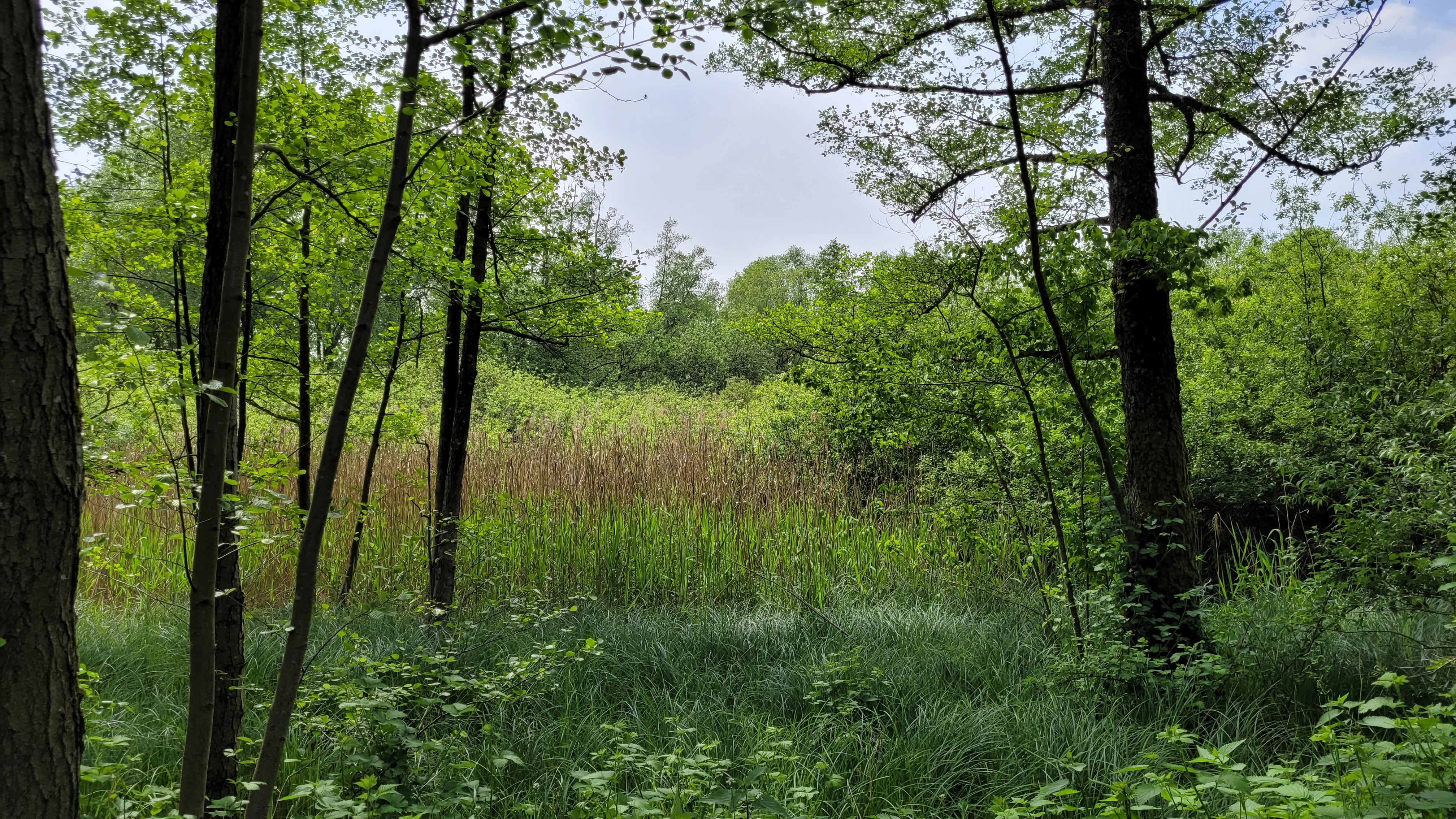
A view into a dense swamp forest with vibrant green trees and tall reeds in the foreground.
A lush swamp forest and wetland area within the Bruch von Brensbach nature reserve.

Bruch von Brensbach history and protected-area timeline

The formal history of Bruch von Brensbach as a protected area began on 27 September 1983, when it was designated as a Naturschutzgebiet through an official ordinance. Its establishment was effectively a recognition of a habitat that had already survived in the landscape, but that was increasingly under pressure from the surrounding agricultural use and former drainage practices in the Gersprenz valley.

The reserve's designation reflects a broader phase in German nature conservation, when small, ecologically focused sites were increasingly being placed under formal protection in order to preserve surviving fragments of habitats such as wet woodlands and reed beds. In the case of Bruch von Brensbach, the legal protection underscored the area's role as the last significant refuge for the wetland birdlife of the lower Gersprenz valley, a function it continues to serve under the category of a habitat and species management area.

Bruch von Brensbach landscape and geographic character

The landscape of Bruch von Brensbach is defined above all by its valley-floor setting within the Gersprenz river system. The reserve sits in the flatter, moister part of the valley, where water collects and supports a wetland habitat distinct from the surrounding hills and slopes of the Odenwald. The terrain itself is very gentle, falling within only a few meters of elevation across the protected area, in the range of approximately 174 to 177 meters above sea level.

The wetland's surface is shaped by the Kilsbach, a small stream that flows through the reserve on its way to join the Gersprenz to the north. Around the stream, conditions are sufficiently waterlogged to sustain a Bruchwald, a moist forest in which tree species adapted to wet soils dominate, alongside extensive reed stands that form dense, marsh-like patches. The result is a landscape of still, shallowly flooded woodland and reedbeds, framed by drier agricultural land and an old orchard to the east.
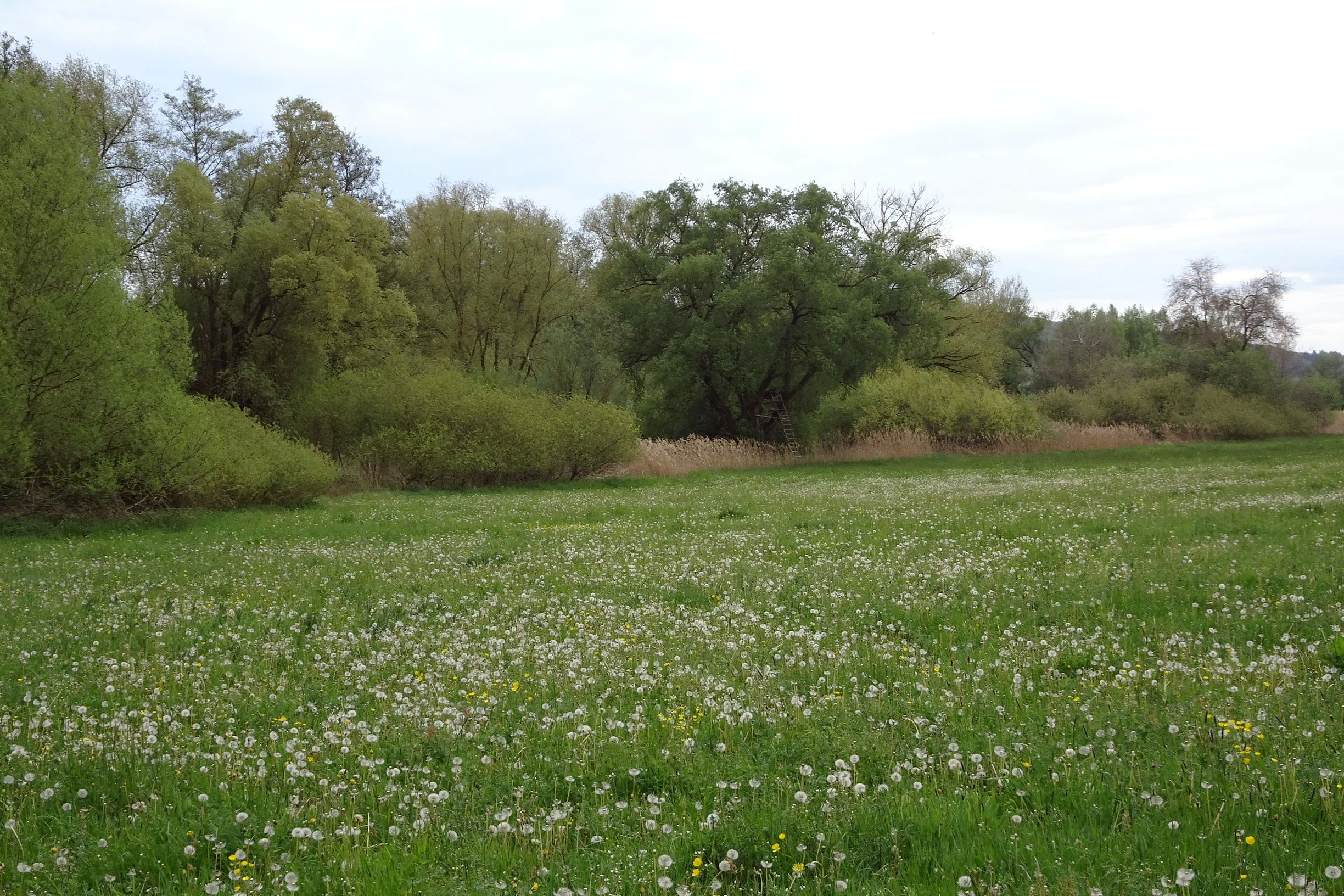
A green meadow with numerous white dandelion seed heads in the foreground, leading up to a line of dense, leafy green trees and shrubbery under an overcast sky.
A meadow filled with flowering plants bordering a patch of dense swamp forest at Bruch von Brensbach nature reserve.

Bruch von Brensbach ecosystems, habitats, and plant life

Ecologically, Bruch von Brensbach is a classic example of a small, lowland valley wetland integrated into a broader cultural landscape. The community of plants at its center is a Bruchwald, the German term for a moist, often alder-dominated forest typical of lowland stream floodplains, interwoven with substantial reed beds that occupy the wettest pockets along the Kilsbach.

The surrounding matrix is dominated by agricultural land, primarily managed grassland and fields. This pattern of intensive land use isolates the protected wetland from similar habitats, making the reserve function as a refuge rather than as part of a continuous ecological corridor. The presence of a traditional Streuobstwiese orchard on the eastern boundary adds an additional semi-natural habitat, helping to soften the abrupt transition between protected wetland and cultivated land.
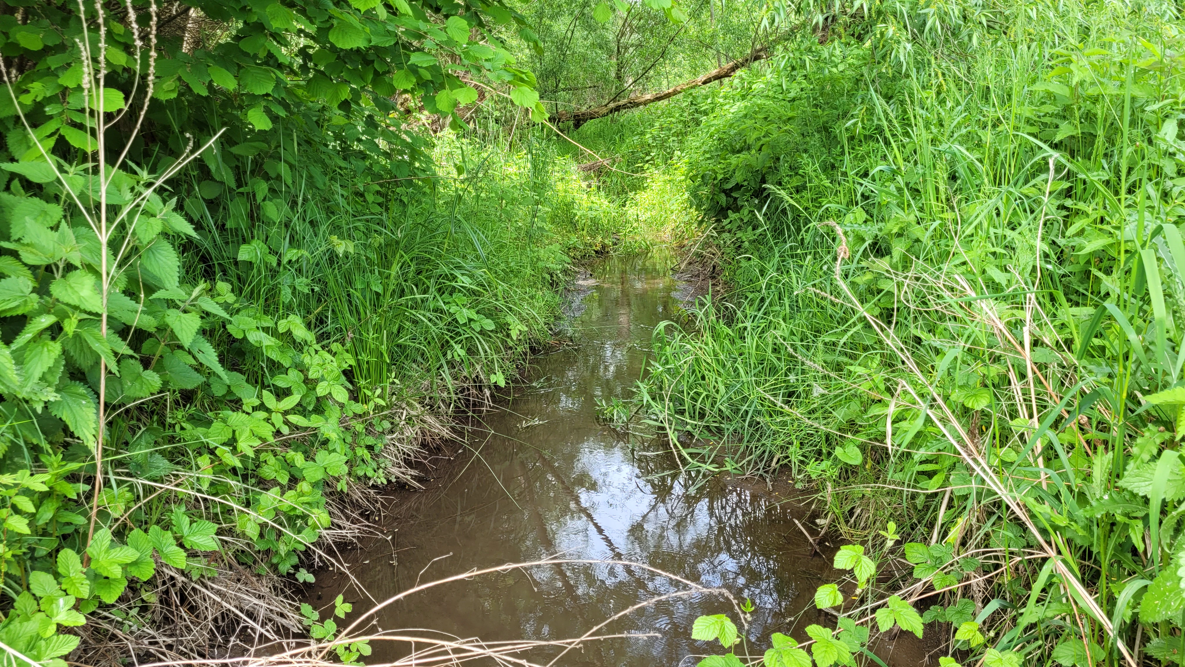
A narrow, dark stream flowing through dense green grasses and overhanging trees in a swampy forest setting.
The Kilsbach stream flowing through the lush vegetation of the Bruch von Brensbach nature reserve.

Bruch von Brensbach wildlife and species highlights

The principal wildlife significance of Bruch von Brensbach lies in its role as a refuge for marshland and wetland-dependent birds of the Gersprenz valley. The combination of standing water, reed beds, and moist woodland along the Kilsbach provides the specific habitat structure required by this ecological group, which is otherwise largely absent from the surrounding agricultural landscape.

Because the reserve was specifically established to preserve these species, its value is understood in terms of refuge function rather than species diversity alone: a small, protected site where vulnerable bird communities associated with traditional lowland wetlands can survive within an otherwise heavily modified valley landscape.
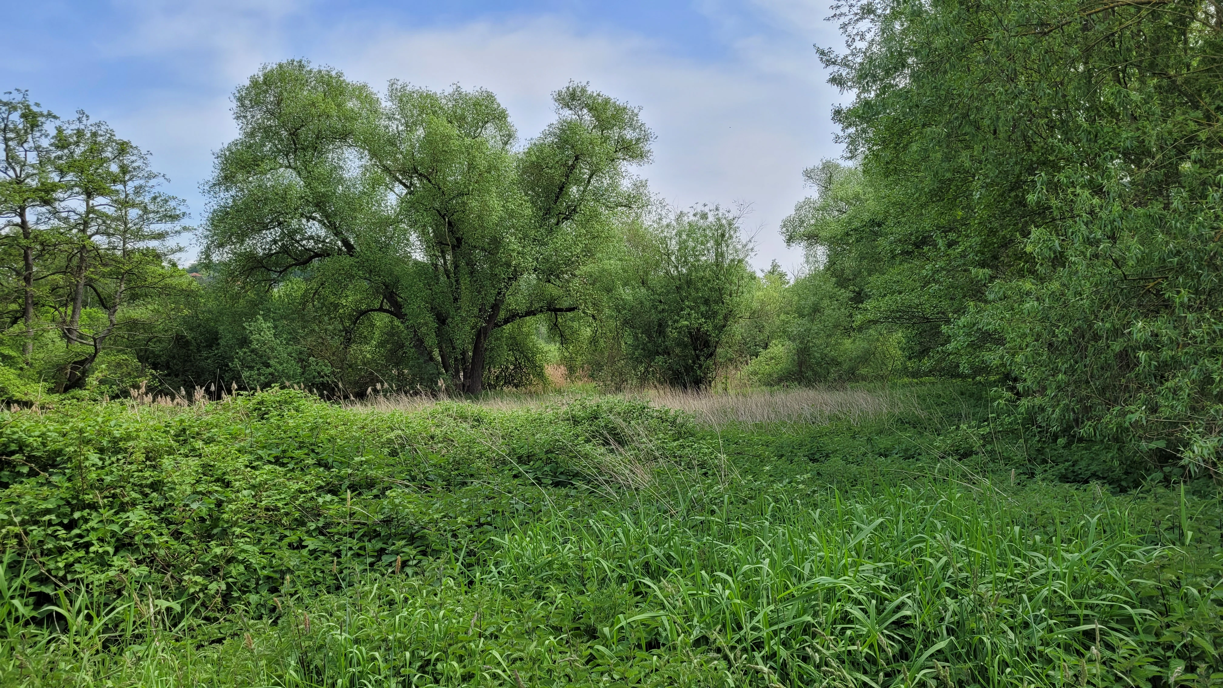
A green, overgrown wetland landscape in the Bruch von Brensbach reserve, featuring lush grasses in the foreground and a dense swamp forest with leafy deciduous trees in the midground.
The wetland habitat within the Bruch von Brensbach nature reserve.

Bruch von Brensbach conservation status and protection priorities

Bruch von Brensbach has been a designated Naturschutzgebiet since 27 September 1983, providing it with formal protection under German conservation law. Within international classification systems, the area is recorded in the World Database on Protected Areas and is categorized under IUCN Category IV, indicating its primary purpose as a habitat and species management area, rather than a broader wilderness reserve.

The central conservation rationale for the reserve is its function as the last significant refuge for the wetland birdlife of the Gersprenz valley. By protecting the Bruchwald, reed beds, and watercourse of the Kilsbach against further alteration, the reserve preserves a small but ecologically important fragment of the valley's natural heritage. Its effectiveness depends on maintaining the hydrological conditions that sustain the wet woodland and reedbeds, and on continuing to buffer the site from further agricultural intensification in the immediately surrounding landscape.

Bruch von Brensbach cultural meaning and human context

Bruch von Brensbach sits within a cultural landscape that has been shaped by centuries of traditional farming in the Odenwald region. The presence of a Streuobstwiese, a traditional orchard of scattered fruit trees, along the eastern edge of the reserve is a direct expression of this historical land-use pattern, in which small-scale orchards formed an integral part of village-based agriculture.

In this broader context, the reserve represents a deliberate effort to retain a natural element of the valley floor, the wetland along the Kilsbach, within a working agricultural landscape, balancing the productive use of the land with the preservation of its remaining ecological heritage.

Top sights and standout views in Bruch von Brensbach

Bruch von Brensbach stands out as a small but ecologically focused nature reserve centered on a surviving fragment of carr woodland and reed beds in the Gersprenz valley. Its defining quality is its refuge function, providing habitat for the marshland bird community of a valley where most similar habitats have been lost. The contrast between the wet, protected interior and the surrounding farmland, including a traditional orchard to the east, gives the reserve a strongly defined sense of place.

Best time to visit Bruch von Brensbach

As a quiet, lowland wetland reserve, Bruch von Brensbach is most interesting to visit in the warmer half of the year, when reed beds and wet woodland are biologically active and when marshland birds are most likely to be present and audible. Spring and early summer tend to be especially rewarding for observing wetland-dependent birdlife, while late summer offers dense reed growth and a strong sense of the site's character as a working marsh habitat. The reserve is not a high-attraction scenic destination, and visitors generally come for ecological interest rather than landscape spectacle.

Monthly climate preview

Long-term monthly temperature averages and precipitation trends for Hesse

Bruch von Brensbach Climate Normals and Annual Temperature Patterns

Historical climate records for Bruch von Brensbach document measured long-term temperature ranges and monthly precipitation averages across representative coordinates in Hesse. Examining the complete twelve-month climatology profile clarifies annual weather patterns and long-term environmental norms for the protected area.
Annual mean10 °C
0 °C21 °C
Jan
Feb
Mar
Apr10°
May14°
Jun18°
Jul21°
Aug20°
Sep15°
Oct10°
Nov
Dec
Warmest month
July

20.6 °C

Coolest month
January

0.2 °C

Wettest month
July

2.2 mm/day

Driest month
April

1.4 mm/day

Park location guide

Geography guide, regional context, and park location map for Bruch von Brensbach

Bruch von Brensbach park geography, regions, and map view in Germany

Understand where Bruch von Brensbach sits in Germany through a broader geographic reading of the surrounding landscape, nearby location context, and its mapped position within the national park landscape.

How Bruch von Brensbach fits into Germany

Germany is a federal republic in Western and Central Europe with a population of over 83 million across sixteen constituent states. It is Europe's largest economy by nominal GDP and a major global exporter and importer. The capital is Berlin, and the country borders Denmark, Poland, Czech Republic, Austria, Switzerland, France, Luxembourg, Belgium, and the Netherlands.

Wider geography shaping Bruch von Brensbach in Germany

Germany is located in Western and Central Europe, spanning 357,022 km². It borders Denmark to the north, Poland and the Czech Republic to the east, Austria and Switzerland to the south, and France, Luxembourg, Belgium, and the Netherlands to the west. The country has coastlines on the Baltic Sea and North Sea to the north, with the Alps located in the southern region.

Map view of Bruch von Brensbach

Use this park location map to pinpoint Bruch von Brensbach in Germany, understand its exact geographic position, and read its mapped placement within the surrounding landscape more clearly.

Pigeon | © OpenStreetMap contributors

Location context for Bruch von Brensbach

Hesse

Visual reference collection showcasing the protected carr woodland and valley terrain

Bruch von Brensbach Photos, Landscape Scenery, and Wetland Habitats

Visual documentation captures the unique wetland terrain and alder carr woodland defining the Gersprenz valley refuge. Photographic records illustrate the protected habitats and stream channels providing vital sanctuary for regional marshland wildlife.

A view into a dense swamp forest with vibrant green trees and tall reeds in the foreground.

A meadow orchard with scattered fruit trees and tall green grass in the Bruch von Brensbach nature reserve in Germany.

A green meadow with numerous white dandelion seed heads in the foreground, leading up to a line of dense, leafy green trees and shrubbery under an overcast sky.

A narrow, dark stream flowing through dense green grasses and overhanging trees in a swampy forest setting.

A green, overgrown wetland landscape in the Bruch von Brensbach reserve, featuring lush grasses in the foreground and a dense swamp forest with leafy deciduous trees in the midground.

A dense, green swamp forest scene with calm water reflecting surrounding trees and thick, lush ground vegetation.

Park atlas

Discover adjacent nature reserves and regional wetland landscapes across southern Hesse

Explore Parks Near Bruch von Brensbach and Surrounding Protected Areas

Continue geographic comparison by browsing other protected areas located near Bruch von Brensbach in the Gersprenz valley. Examining these neighboring valley habitats provides wider context for regional wetland preservation and lowland river ecosystems.
A soft watercolor illustration depicting a green, hilly landscape with meadows and distant low slopes on a white background.
Nature reserveHesse
About 5.7 km away#1 closest

Northwest

Forstberg von Ueberau: A Volcanic Nature Reserve and Protected Landscape in Hesse, Germany

Geographic atlas of an extinct volcano and dry grassland refuge.

Forstberg von Ueberau serves as a vital ecological anchor within the Reinheimer Hügelland. This 30-hectare nature reserve preserves an unusual volcanic substrate, featuring a crater-shaped basalt quarry surrounded by seminatural meadows and hedgerows. The site stands as a prime example of habitat management where traditional agricultural practices and biodiversity protection converge to sustain Red List species in a structured, open-country setting.

Area
0.305 km²
Established
1990
IUCN
IV
Nature reserveHesse
About 8.4 km away#2 closest

Southeast

Rohrsee von Rehbach Nature Reserve: Protected Wetland Atlas and Regional Geography

Wetland ecosystems in the sandstone Odenwald region of Hesse

Examine the geography of Rohrsee von Rehbach, an IUCN category protected area in southern Hesse. The site features a man-made pond and significant reed habitats that offer a rare wetland contrast to the surrounding sandstone terrain. Our atlas details the reserve's topography, hydrologic features, and its function as a managed refuge for waterbirds in the Odenwald landscape.

Area
0.156 km²
Established
1986
IUCN
IV
A soft watercolor painting of a wetland landscape with rolling hills in the background, a body of water in the middle, and green grass in the foreground.
Nature reserveHessen
About 8.8 km away#3 closest

East

Bruch von Bad König und Etzen-Gesäß: Nature Reserve and Floodplain Geography

Protected wetland landscapes in the Odenwald region of Hessen

Located along the Mümling river, this nature reserve protects a vital network of moist meadows, reed beds, and softwood forests. The site offers a clear view into the alluvial geography of the Odenwald, showcasing how protected floodplain corridors function within a developed regional landscape.

Area
0.427 km²
Established
1980
IUCN
IV
Relief
Lowland
Watercolor painting of a wide, low-horizon landscape featuring a line of green trees against a pale pink sky over a pale, sandy foreground.
Nature reserveHessen
About 9.1 km away#4 closest

Northeast

Sandsteinbrüche am Burzelberg bei Frau-Nauses Protected Nature Reserve and Quarry Atlas

Odenwald mountain range, Hessen protected area

Examine the geography of Sandsteinbrüche am Burzelberg bei Frau-Nauses, a protected nature reserve in Hessen. This site features striking Buntsandstein quarry walls and rewilded forest edges, providing a specialized environment for cliff-nesting raptors and documenting local industrial history through its geological formations.

Area
0.195 km²
Established
1994
Relief
Upland
Climate
Temperate
Watercolor painting of a tranquil pond landscape with soft green reeds, grasses, and low trees under a pale, muted sky.
Nature reserveHesse
About 9.5 km away#5 closest

North

Reinheimer Teich Nature Reserve: Mapped Wetlands and Biodiversity in Hesse, Germany

A lowland wetland refuge in the Reinheimer Becken

Reinheimer Teich represents a significant nature reserve in the Darmstadt-Dieburg district of Hesse. This protected area features a mosaic of reed beds, wet meadows, and open water channels. It is recognized as one of the final strongholds for the European pond turtle and remains a key node within the Untere Gersprenz river system, demonstrating the vital role of floodplain restoration in local landscape conservation.

Area
0.75 km²
Established
1975
IUCN
IV
Relief
Lowland
A wide watercolor painting showing a river flowing through a green meadow with trees and distant hills.
Protected areaHesse
About 11 km away#6 closest

North

Scheelhecke von Groß-Zimmern Protected Area, Hesse: A Wetland and Riverine Landscape Study

Key protected wetland features in the Reinheimer Hügelland

Scheelhecke von Groß-Zimmern protects an essential network of wet meadows and brook corridors in the Darmstadt-Dieburg district. Its geography encompasses a transition from open sedge-dominated floodplain to softwood forest, providing critical support for avian species and amphibians within the Natura 2000 Gersprenz network.

Area
0.046 km²
Established
1983
Relief
Upland
Climate
Temperate
Watercolor painting showing a stylized, panoramic landscape of rolling hills and forest, depicted in soft green and earth tones against a white background.
Nature reserveHessen
About 13 km away#7 closest

West

Felsberg bei Reichenbach Nature Reserve: Geography and Granite Boulder Field Analysis

Protected forest and geological monument in the Odenwald range

Felsberg bei Reichenbach protects 168 hectares of Odenwald mountain slope in Southern Hessen. The site is centered on the Felsenmeer, a dramatic sea of granite boulders created by frost weathering, framed by mixed deciduous woodland. This area functions as an important Natura 2000 habitat, preserving both specialized rock ecosystems and montane forest, providing a clear geographic link between the Lautertal valley and the high slopes of the Felsberg summit.

Area
1.677 km²
Established
1972
IUCN
IV
Relief
Mountain
A horizontal watercolor illustration of a soft green landscape with meadows, scattered trees, and distant rolling hills under a pale pink sky.
Nature reserveHessen
About 14 km away#8 closest

Southwest

Schannenbacher Moor Nature Reserve: Geographic Overview and Protected Area Boundaries

Wetland and forest mosaic in the southern Hessian Odenwald

Schannenbacher Moor represents a significant protected area within Hessen, characterized by its combination of raised bog remnants, reedbeds, and near-natural floodplain woodlands. Framed by the Krehberg slopes and the Meerbach stream system, the reserve offers a rare example of low mountain bog ecology and biodiversity conservation. This mapped landscape provides essential data on the distribution of mire plant communities and bryophyte habitats in the region.

Area
0.162 km²
Established
1975
IUCN
IV

Common questions about visiting, size, designation, and location context for Bruch von Brensbach

Bruch von Brensbach FAQs for park facts, access, geography, and protected area context

Find quick answers about Bruch von Brensbach, including protected-area facts, park geography, trail and visitor context, and how the park fits into its surrounding country and regional landscape.
MoriAtlas Explorer

Continue Your Protected Areas Search Across the Global Atlas

Deepen your exploration by continuing the structured search for national parks and protected areas worldwide. Utilize the comprehensive filtering capabilities to compare different conservation landscapes and refine your understanding of global park geography. Discover more about the distribution and characteristics of protected natural areas.

Global natural geography