

Mori Atlas logo
Nature reserveBrunswick Heads Nature Reserve

A vital protected sanctuary on the Northern Rivers coast of New South Wales

Brunswick Heads Nature Reserve: Mapped Littoral Rainforest and Coastal Protected Landscapes

Brunswick Heads Nature Reserve preserves a rare and intact fragment of Australian littoral rainforest within the Northern Rivers region of New South Wales. This protected landscape encompasses a compact mosaic of dense forest, coastal dunes, and estuarine habitats along the Brunswick River. By safeguarding these fragile coastal ecosystems, the reserve serves as a crucial reference point for understanding the diverse plant and animal species native to this unique intersection of forest and sea.

littoral rainforestcoastal reserveNorthern RiversNew South Walesnature reservebirdwatching

Brunswick Heads Nature Reserve

Nature reserve

Park overview

Structured park overview, official facts, and landscape profile for Brunswick Heads Nature Reserve

Brunswick Heads Nature Reserve park facts, protected area profile, and essential visitor context

Review the core facts for Brunswick Heads Nature Reserve, including designation, size, terrain, visitor scale, habitats, and operating context in one park-focused overview.

About Brunswick Heads Nature Reserve

Brunswick Heads Nature Reserve is a small but ecologically significant protected area on the New South Wales far north coast. Sitting in the Northern Rivers region, it lies along the coastal strip between the town of Brunswick Heads and the residential area of Ocean Shores. The reserve is administered as a New South Wales nature reserve and is managed by the NSW National Parks and Wildlife Service, which places it within a broader state framework of conserving native vegetation and wildlife habitats.

The defining feature of the reserve is its stand of littoral rainforest, a vegetation type that once fringed large parts of the eastern Australian coastline but has been reduced to scattered remnants due to land clearing for agriculture, mining, and coastal development. Within Brunswick Heads Nature Reserve, this rainforest community has survived largely intact, which gives it considerable conservation value well beyond what its 221-hectare footprint might suggest.

The reserve is also notable for the way it links terrestrial and coastal environments. Its rainforest interior meets sandy beach, dune, and estuarine habitats along the Brunswick River system, producing layered habitat zones in a compact area. This makes the reserve a useful teaching site for school groups and a place where visitors can encounter rainforest, shorebird habitat, and open coast within a short walk.

For the surrounding communities of Brunswick Heads and Ocean Shores, the reserve functions as both a conservation site and a local outdoor destination. Walking, cycling, birdwatching, picnicking, canoeing, and fishing in nearby waters are common activities, allowing residents and visitors to engage with the reserve without the logistical demands of a larger national park. Its accessibility and ecological compactness together give Brunswick Heads Nature Reserve an identity that is more about concentrated natural value than about grand scale.

Quick facts and research context for Brunswick Heads Nature Reserve

Brunswick Heads Nature Reserve is a small New South Wales nature reserve covering roughly 221 hectares within the Northern Rivers region of eastern Australia. The reserve lies between the townships of Brunswick Heads and Ocean Shores, close to the coast and the mouth of the Brunswick River.

Its core conservation value is an intact stand of littoral rainforest, a coastal vegetation community that has been heavily cleared for agriculture, mining, and housing elsewhere in Australia. The reserve sits within a landscape that also includes beaches, estuarine waters, and coastal heath, giving it a layered mix of rainforest, shoreline, and estuary habitats in a compact area.

Protection and recognition

Detailed terrestrial protection status and international recognition metrics

Brunswick Heads Nature Reserve Protection Status and Governance Framework

Brunswick Heads Nature Reserve maintains a documented terrestrial protection scope within the regional conservation network. Structured conservation records outline established protected area parameters and formal designation frameworks for the protected landscape.

Protection details

Protection scope
Terrestrial
Transboundary protection
No
Park context

Deeper park guide and search-rich context for Brunswick Heads Nature Reserve

Brunswick Heads Nature Reserve history, landscape, wildlife, and travel context

Explore Brunswick Heads Nature Reserve through its history, landscape character, ecosystems, wildlife, conservation priorities, cultural context, and seasonal travel timing in a structured park guide built for atlas discovery and search intent.

Why Brunswick Heads Nature Reserve stands out

Brunswick Heads Nature Reserve is best known for protecting one of the remaining intact stands of Australian littoral rainforest. Littoral rainforest is a globally significant vegetation type that grows on coastal lowlands and headlands in eastern Australia, and most of its former extent has been lost to land clearing. What makes this particular reserve distinctive is the combination of rare rainforest trees, such as the Stinking Cryptocarya and scented acronychia, with coastal surroundings that include endangered shorebird habitat and seasonal marine wildlife. Despite its modest size, the reserve is therefore a key reference site for understanding what these coastal rainforests once looked like and which species they support.
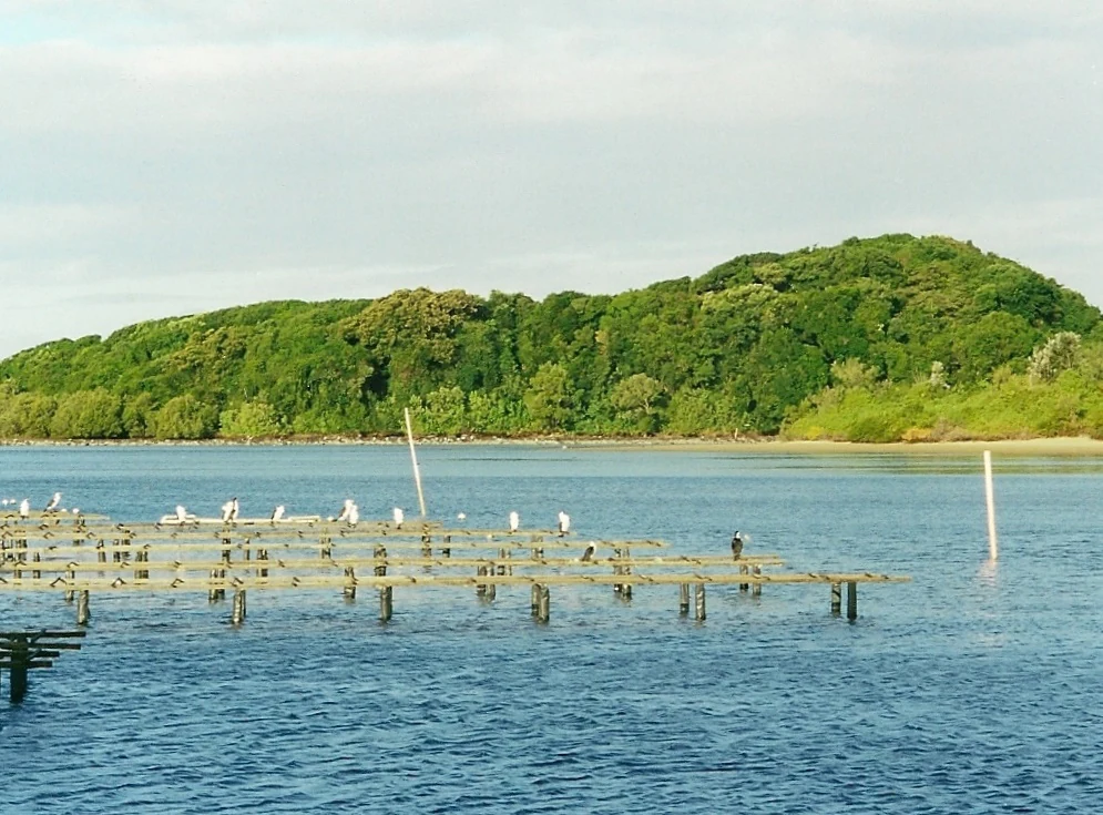
A view across a body of water toward a densely forested hill, with wooden oyster farming racks in the foreground hosting several white birds.
Littoral rainforest and oyster farming structures along the water at Brunswick Heads Nature Reserve.

Brunswick Heads Nature Reserve history and protected-area timeline

The reserve was established in January 1979, formalising the protection of one of the surviving patches of littoral rainforest in the Brunswick Heads area. Its creation came against a backdrop of widespread clearing of coastal lowland rainforest across eastern Australia, where many former littoral rainforest sites had already been converted to farmland, housing, or extractive industry uses.

By the time of its designation, the reserve was already recognised as containing an intact example of this vegetation type, along with associated plant and animal species of conservation concern. Following its gazetting, the reserve has been managed by the relevant New South Wales state authorities, and it continues to be valued as a reference site for a coastal rainforest community that has largely vanished elsewhere on the Australian east coast.

Brunswick Heads Nature Reserve landscape and geographic character

The landscape of Brunswick Heads Nature Reserve is shaped by its position on a narrow coastal strip where forest meets the sea. Inland from the shoreline, the terrain rises gently into low coastal hills and flats covered by closed-canopy rainforest. Typical features include vine-clad trees, shaded gullies, and a dense understorey, with leaf litter and fallen timber giving the interior a deeply sheltered character.

At the edges of the rainforest, the reserve transitions toward coastal sand systems, dune vegetation, and estuarine flats associated with the Brunswick River. This produces a striking contrast: dark, humid rainforest interiors giving way abruptly to bright open beach, tidal flats, and salt-influenced shoreline habitats. The result is a compact landscape mosaic where tall trees, coastal heath, dune plants, and marine shoreline occur in close proximity.

Because the reserve sits between the townships of Brunswick Heads and Ocean Shores, the surrounding human landscape is also significant. Residential streets, holiday housing, and small-town infrastructure frame the park, making the rainforest stand feel like a green pocket embedded within a developed coastal strip rather than a remote wilderness.

Brunswick Heads Nature Reserve ecosystems, habitats, and plant life

Ecologically, Brunswick Heads Nature Reserve is dominated by littoral rainforest, a vegetation community found on coastal lowlands and headlands in eastern Australia. Littoral rainforest typically includes a mix of evergreen rainforest trees, vines, and palms adapted to sandy, sometimes saline-influenced soils close to the ocean. The reserve holds an intact example of this community, which is otherwise reduced to scattered remnants along the east coast.

The rainforest structure supports a layered habitat profile: a tall canopy of rainforest trees, a mid-layer of smaller trees and shrubs, and a ground layer of ferns, vines, and leaf litter. This variety of vertical structure provides habitat for fruit-eating birds, flying foxes, and insects that depend on continuous canopy cover. Where the rainforest gives way to the coast, vegetation patterns also include dune plants, coastal heath, and estuarine-margin species that tolerate salt and shifting sands.

The reserve's ecological importance is heightened by the fact that littoral rainforest is among Australia's most reduced vegetation types. Most former occurrences have been cleared for agriculture, mining, or urban expansion, so the persistence of an intact stand at Brunswick Heads gives the site a conservation significance that exceeds its modest area.

Brunswick Heads Nature Reserve wildlife and species highlights

Brunswick Heads Nature Reserve hosts a mix of rainforest-dependent wildlife, shorebirds, and seasonal marine visitors. The canopy and fruiting trees of the littoral rainforest support fruit bats, including the very small common blossom bat, which is known to feed in and around the park, and the grey-headed flying fox, a species of conservation concern that roosts and forages in coastal vegetation.

Along the shoreline and adjacent estuarine waters, the reserve is used by threatened beach-nesting and shore-feeding birds such as pied oystercatchers and beach stone-curlews. The dune and heath margins also provide habitat for small ground-dwelling species such as the wallum froglet, a frog associated with coastal wallum habitats in this region of New South Wales.

Marine and seasonally mobile wildlife adds another dimension. Loggerhead turtles are recorded in the waters off the reserve, and humpback whales pass through the area during their annual migration along the east Australian coast. Together, these rainforest, beach, and marine elements give the reserve a notably wide range of wildlife for such a small site.

Brunswick Heads Nature Reserve conservation status and protection priorities

From a conservation perspective, the reserve's most important role is safeguarding an intact example of littoral rainforest, a vegetation type that has been heavily cleared across its former range. Littoral rainforest now exists mainly as isolated remnants, and the survival of a substantial, unmodified patch at Brunswick Heads gives the site regional and state-level significance for biodiversity conservation.

The reserve also contributes to the protection of multiple threatened species that depend on its combined rainforest and coastal habitats. These include rare rainforest plants such as Stinking Cryptocarya, scented acronychia, Queensland xylosma, durobby, and white lace flower, alongside threatened fauna like the grey-headed flying fox, wallum froglet, loggerhead turtle, and beach-nesting shorebirds such as pied oystercatchers and beach stone-curlews.

As a New South Wales nature reserve managed by the NSW National Parks and Wildlife Service, the site is part of a formal state reserve system, which provides a framework for ongoing management of threats such as invasive species, edge effects from surrounding development, and disturbance to nesting wildlife. Even at 221 hectares, the reserve therefore contributes meaningfully to the broader effort to preserve coastal rainforest biodiversity in eastern Australia.

Brunswick Heads Nature Reserve cultural meaning and human context

Brunswick Heads Nature Reserve is closely tied to the local identity of the Brunswick Heads and Ocean Shores communities on the New South Wales far north coast. The reserve sits within a region known for a strong environmental consciousness and a tradition of small-scale coastal nature-based recreation, and it functions as a much-used outdoor classroom for local schools and visitors.

The reserve's value as an educational and recreational site complements its ecological role. School excursions, community birdwatching, and family-oriented activities such as picnicking and short bushwalks reflect the way the reserve is woven into everyday life in this part of the Northern Rivers.

Top sights and standout views in Brunswick Heads Nature Reserve

The standout features of Brunswick Heads Nature Reserve centre on the survival of an intact littoral rainforest stand in a region where most of this vegetation has been cleared. The reserve supports rare rainforest plants, including Stinking Cryptocarya and scented acronychia, and threatened coastal wildlife ranging from the wallum froglet to beach stone-curlews and seasonal humpback whale sightings offshore.

Equally distinctive is the compressed habitat mosaic: rainforest interior, dune and beach shoreline, and Brunswick River estuary habitats all coexist within a small footprint. This makes the reserve unusually rich per hectare and accessible, offering visitors a complete slice of the New South Wales coastal rainforest landscape in walking distance from nearby townships.

Best time to visit Brunswick Heads Nature Reserve

Brunswick Heads Nature Reserve can be visited year-round, but the experience changes with the seasons. Cooler and drier months tend to make rainforest walking more comfortable, while the warmer months bring flowering and fruiting in the rainforest understorey, which can increase wildlife activity and improve chances of spotting fruit bats and bush birds.

The coastal aspect of the reserve also shapes seasonality. Migratory shorebirds and nesting species are most active during certain parts of the year, and the annual humpback whale migration along the east Australian coast, generally during the cooler half of the year, offers an added draw for visitors using the reserve's beach areas as a viewing point.

Monthly climate preview

Long-term representative point measurements tracking monthly temperature and precipitation rhythm

Brunswick Heads Nature Reserve Climate Normals and Annual Weather Patterns

Representative coordinate records show average monthly temperatures ranging from seventeen to twenty five degrees alongside distinct seasonal precipitation variations. Examining the complete twelve month climate profile reveals detailed monthly averages across the entire protected landscape.
Annual mean21 °C
18 °C25 °C
Jan25°
Feb25°
Mar24°
Apr23°
May21°
Jun19°
Jul18°
Aug18°
Sep20°
Oct21°
Nov22°
Dec24°
Warmest month
February

24.8 °C

Coolest month
July

17.8 °C

Wettest month
February

5.9 mm/day

Driest month
September

1.3 mm/day

Park location guide

Geography guide, regional context, and park location map for Brunswick Heads Nature Reserve

Brunswick Heads Nature Reserve park geography, regions, and map view in Australia

Understand where Brunswick Heads Nature Reserve sits in Australia through a broader geographic reading of the surrounding landscape, nearby location context, and its mapped position within the national park landscape.

How Brunswick Heads Nature Reserve fits into Australia

Australia is a constitutional monarchy and federal parliamentary democracy comprising six states and ten territories. With a population of nearly 28 million, it is one of the world's most urbanised countries, with most people concentrated on the eastern seaboard. The country has a high Human Development Index and is known for its cultural diversity, ancient Aboriginal heritage, and unique wildlife.

Wider geography shaping Brunswick Heads Nature Reserve in Australia

Australia occupies the entire Australian continent, the island of Tasmania, and numerous smaller islands. It is the world's flattest and driest inhabited continent, featuring vast deserts in the interior (the Outback), tropical rainforests along the eastern coast, and a coastline bordering the Indian and Pacific Oceans.

Map view of Brunswick Heads Nature Reserve

Use this park location map to pinpoint Brunswick Heads Nature Reserve in Australia, understand its exact geographic position, and read its mapped placement within the surrounding landscape more clearly.

Pigeon | © OpenStreetMap contributors

Location context for Brunswick Heads Nature Reserve

New South Wales

Visual exploration of coastal rainforest habitats and protected shoreline terrain

Brunswick Heads Nature Reserve Photos and Landscape Scenery

Visual documentation of Brunswick Heads Nature Reserve captures the rare littoral rainforest, coastal dunes, and estuarine environments of northern New South Wales. Examining protected area photography reveals the compact vegetation mosaic and sheltered terrain defining this coastal sanctuary.

A view across a body of water toward a densely forested hill, with wooden oyster farming racks in the foreground hosting several white birds.

Park atlas

Compare nearby regional reserves, coastal habitats, and connected protected landscapes

Other Parks Near Brunswick Heads Nature Reserve and Surrounding Coastal Protected Areas

Browse protected areas and coastal nature reserves located near Brunswick Heads Nature Reserve in New South Wales. Comparing adjacent regional geography reveals broader patterns in coastal rainforest conservation and estuarine habitat distribution.
Nature reserveNew South Wales
About 8 km away#1 closest

South

Tyagarah Nature Reserve: A Protected Coastal Landscape Atlas in Northern New South Wales

Coastal dunes, endangered ecosystems, and whale migration geography.

Located along the Pacific coast of New South Wales, Tyagarah Nature Reserve features seven kilometers of undeveloped beach backed by a mosaic of stable dunes and wetland habitats. The area provides a critical sanctuary for numerous threatened plant species and serves as a premier vantage point for tracking migrating humpback whales from the shore. This site represents a convergence of Indigenous cultural history and vital coastal conservation landscapes in the Byron Shire.

Area
8.75 km²
Relief
Lowland
Climate
Subtropical
Scope
Terrestrial
Nature reserveNew South Wales
About 11 km away#2 closest

Southeast

Nguthungulli Julian Rocks Nature Reserve: Atlas of Coastal Protected Marine Landscapes

Geographic overview of basalt islands and Tasman Sea marine environments.

Nguthungulli Julian Rocks Nature Reserve represents a rare convergence of marine geography off the coast of New South Wales. These two rocky islets provide a dense, structured habitat where warm and cool currents meet. The reserve acts as a focal point for understanding regional coastal conservation, Indigenous cultural heritage, and the intricate, submerged basalt formations that define this significant Australian protected area.

Area
40.47 km²
Established
1961
IUCN
Ia
Relief
Lowland
National parkNew South Wales
About 12 km away#3 closest

West

Mount Jerusalem National Park: Ancient Volcanic Terrain and Protected Landscape Discovery in New South Wales

Explore its mapped geography and Albert's lyrebird habitat.

Mount Jerusalem National Park stands as a key protected area within the dramatic landscape of New South Wales. Situated on the eroded outer rim of the ancient Tweed Caldera, the park showcases distinctive volcanic terrain shaped over millions of years. Its protected boundaries encompass vital habitats, notably supporting significant populations of Albert's lyrebird, and contribute to the watershed dynamics of the Tweed, Brunswick, and Richmond River systems, offering a rich focus for geographic and landscape exploration.

Area
52 km²
Established
1995
IUCN
II
Relief
Mountain
National parkNew South Wales
About 14 km away#4 closest

West

Goonengerry National Park: New South Wales Protected Landscape and Geography

Discover mapped boundaries and regional context.

Goonengerry National Park is a designated national park in New South Wales, Australia, offering valuable insights for geographic exploration. This entry provides a structured view of its protected area status, focusing on its mapped boundaries and landscape context. Users can explore how Goonengerry National Park fits into the regional geography of New South Wales, enhancing understanding of protected lands within the Australian atlas.

Area
4 km²
Established
1999
IUCN
II
Relief
Upland
National parkNew South Wales
About 14 km away#5 closest

Southeast

Arakwal National Park: National Park Protected Landscape in New South Wales

Explore mapped boundaries and regional geography.

Arakwal National Park stands as a protected national park, offering insights into its distinct landscape and geographic setting within New South Wales. This resource provides detailed information focused on the park's mapped boundaries and its role as a conservation landscape. Users can explore the regional geography and understand the specific protected-area context that defines Arakwal National Park, contributing to a broader atlas understanding.

Area
1.99 km²
Established
2001
IUCN
II
Relief
Lowland
Nature reserveNew South Wales
About 15 km away#6 closest

South

Hayters Hill Nature Reserve: A Significant Big Scrub Rainforest Remnant in New South Wales

Protected subtropical forest in the Northern Rivers hinterland

Hayters Hill Nature Reserve represents a critical protected fragment of the original Big Scrub subtropical rainforests. Situated on elevated ground near Byron Bay, this nature reserve offers insight into the regional topography and the conservation of lowland forest ecosystems in the Northern Rivers area of New South Wales.

Area
0.08 km²
Established
1989
IUCN
IV
Relief
Upland
National parkNew South Wales
About 15 km away#7 closest

Northwest

Mooball National Park: Protected Landscape Identity and Geographic Context in New South Wales

Atlas exploration of its mapped boundaries and regional setting.

Mooball National Park is a key protected area within New South Wales, Australia, offering a distinct focus for atlas and geography exploration. This detail page illuminates its identity as a national park, detailing its mapped geographic presence and the surrounding regional context. Understand the protected landscape's characteristics and its unique position within the broader atlas of Australian natural reserves.

Area
12 km²
Established
1999
IUCN
II
Relief
Lowland
National parkNew South Wales
About 16 km away#8 closest

West

Nightcap National Park: New South Wales Protected Landscape and Geographic Atlas

Mapping the protected area boundaries and natural terrain.

Nightcap National Park is a key protected landscape within New South Wales, Australia, offering distinct opportunities for geographic exploration. This entry provides critical details about its mapped boundaries, surrounding regional terrain, and its role as a national park. Understand the park's specific environmental context and its contribution to the broader atlas of protected lands in the region, ideal for detailed map-based discovery.

Area
81 km²
Established
1983
IUCN
II
Relief
Mountain

Common questions about visiting, size, designation, and location context for Brunswick Heads Nature Reserve

Brunswick Heads Nature Reserve FAQs for park facts, access, geography, and protected area context

Find quick answers about Brunswick Heads Nature Reserve, including protected-area facts, park geography, trail and visitor context, and how the park fits into its surrounding country and regional landscape.
MoriAtlas Explorer

Continue Your Protected Areas Search Across the Global Atlas

Deepen your exploration by continuing the structured search for national parks and protected areas worldwide. Utilize the comprehensive filtering capabilities to compare different conservation landscapes and refine your understanding of global park geography. Discover more about the distribution and characteristics of protected natural areas.

Global natural geography