


Mori Atlas logo
Marine protected areaCabbage Tree Bay Aquatic Reserve

A dense marine refuge encompassing rocky reefs, seagrass meadows, and kelp forest ecosystems

Cabbage Tree Bay Aquatic Reserve: Mapping Coastal Marine Protected Areas in New South Wales

Cabbage Tree Bay Aquatic Reserve functions as a critical no-take marine environment within the urban coastal landscape of New South Wales. This protected zone shelters a diverse range of subtidal habitats including rocky reefs, seagrass meadows, and kelp forests within a compact seventeen-hectare footprint. By tracing its boundaries along the northern Sydney coast, visitors can understand the significance of this area as a refuge for temperate marine life and a focal point for regional climate range shift monitoring.

marine protected areaaquatic reserveno-take zonerocky reefkelp forestseagrass meadow
A flat-style digital illustration showing a view of a coastline with high cliffs, a waterfall cascading into the sea, and a rocky foreground under a soft sun.

Cabbage Tree Bay Aquatic Reserve

Marine protected area

Park overview

Structured park overview, official facts, and landscape profile for Cabbage Tree Bay Aquatic Reserve

Cabbage Tree Bay Aquatic Reserve park facts, protected area profile, and essential visitor context

Review the core facts for Cabbage Tree Bay Aquatic Reserve, including designation, size, terrain, visitor scale, habitats, and operating context in one park-focused overview.

About Cabbage Tree Bay Aquatic Reserve

Cabbage Tree Bay Aquatic Reserve is a fully protected marine zone on the Pacific-facing shore of North Head, on the northern edge of Sydney Harbour, within the suburb of Manly. Despite covering just 17 hectares, it represents one of the most habitat-rich marine protected areas in greater Sydney, with its short rocky and sandy shoreline giving way to reefs, seagrass, and kelp within a short swim of the beach.

The reserve sits within a heavily used coastal corridor. Manly Beach, its closest neighbor to the northwest, draws an estimated five to eight million visitors each year, while Shelly Beach lies immediately to the east, and the larger Shelly Beach Headland Intertidal Protected Area extends further along the same shoreline. Just to the south, Sydney Harbour National Park protects the cliff-and-headland landscape of North Head, creating a continuous belt of protected natural environment that links marine and terrestrial habitats around the harbor entrance.

The reserve's defining feature is its strict no-take status. All fishing, collecting, or disturbance of marine life, including dead organisms, is prohibited, although swimming, snorkeling, and scuba diving remain permitted. This level of protection has helped the reserve function as a refuge for reef species and as a reference site for understanding shallow Sydney marine biodiversity. The site is also notable in international conservation listings, classified as IUCN Category II in the World Database on Protected Areas, reflecting its national-park-equivalent level of protection.

From a scientific perspective, the reserve has become a small but valuable natural laboratory. Researchers have documented more than 160 fish species and around 50 species of marine invertebrates within its waters, including warm-temperate residents and seasonal tropical visitors. The presence of a colony of the hard coral Pocillopora aliciae, a species more typical of warmer waters, has drawn attention because it suggests that climate-driven range shifts are already being recorded even in heavily urbanized coastlines. For divers, snorkelers, and marine educators, Cabbage Tree Bay offers an unusually accessible window into a strictly protected temperate reef ecosystem in the heart of Australia's largest city.

Quick facts and research context for Cabbage Tree Bay Aquatic Reserve

Cabbage Tree Bay Aquatic Reserve lies on the northern shore of Manly, on Sydney's North Head headland in New South Wales, Australia, and covers 17 hectares of coastal marine habitat. It was gazetted as an aquatic reserve on 31 March 2002, replacing a previous intertidal protected area that had covered the rocky shore since 1993, and is governed by the NSW Department of Primary Industries as a no-take marine zone.

The reserve sits between the iconic Manly Beach, the smaller Shelly Beach, the nearby Shelly Beach Headland Intertidal Protected Area to its east, and Sydney Harbour National Park to the south. It is recorded as an IUCN Category II site in the World Database on Protected Areas and supports more than 160 fish species and roughly 50 marine invertebrate species within its small footprint, along with a small out-of-range colony of the hard coral Pocillopora aliciae.

Protection and recognition

Examine documented marine protection metrics and recognized conservation scope.

Cabbage Tree Bay Aquatic Reserve Protection Status and Governance Data

Cabbage Tree Bay Aquatic Reserve maintains a defined marine protection scope without external transboundary affiliations or imported international recognition sources. Reviewing structured governance records clarifies the baseline conservation status and administrative framework established for the reserve.

Protection details

Protection scope
Marine
Transboundary protection
No
Park context

Deeper park guide and search-rich context for Cabbage Tree Bay Aquatic Reserve

Cabbage Tree Bay Aquatic Reserve history, landscape, wildlife, and travel context

Explore Cabbage Tree Bay Aquatic Reserve through its history, landscape character, ecosystems, wildlife, conservation priorities, cultural context, and seasonal travel timing in a structured park guide built for atlas discovery and search intent.

Why Cabbage Tree Bay Aquatic Reserve stands out

Cabbage Tree Bay is known for the remarkable diversity of marine habitats packed into a very small protected footprint just offshore from urban Sydney. Within its boundaries, divers and snorkelers can move between sandy beach, rocky intertidal platforms, subtidal rocky reefs, seagrass meadows, and kelp forest, encountering species normally associated with much more remote stretches of the New South Wales coast. It is also recognized as a small but important example of a climate-driven shifting range signal, hosting a colony of the tropical hard coral Pocillopora aliciae far south of its typical distribution, and receiving seasonal visits from tropical fish larvae that drift south with the East Australian Current. Combined with its strict no-take status, the reserve functions as a refuge for populations of resident reef fish such as the eastern blue groper (Achoerodus viridis) and long green wrasse (Pseudojuloides elongatus), which thrive in the absence of fishing pressure.
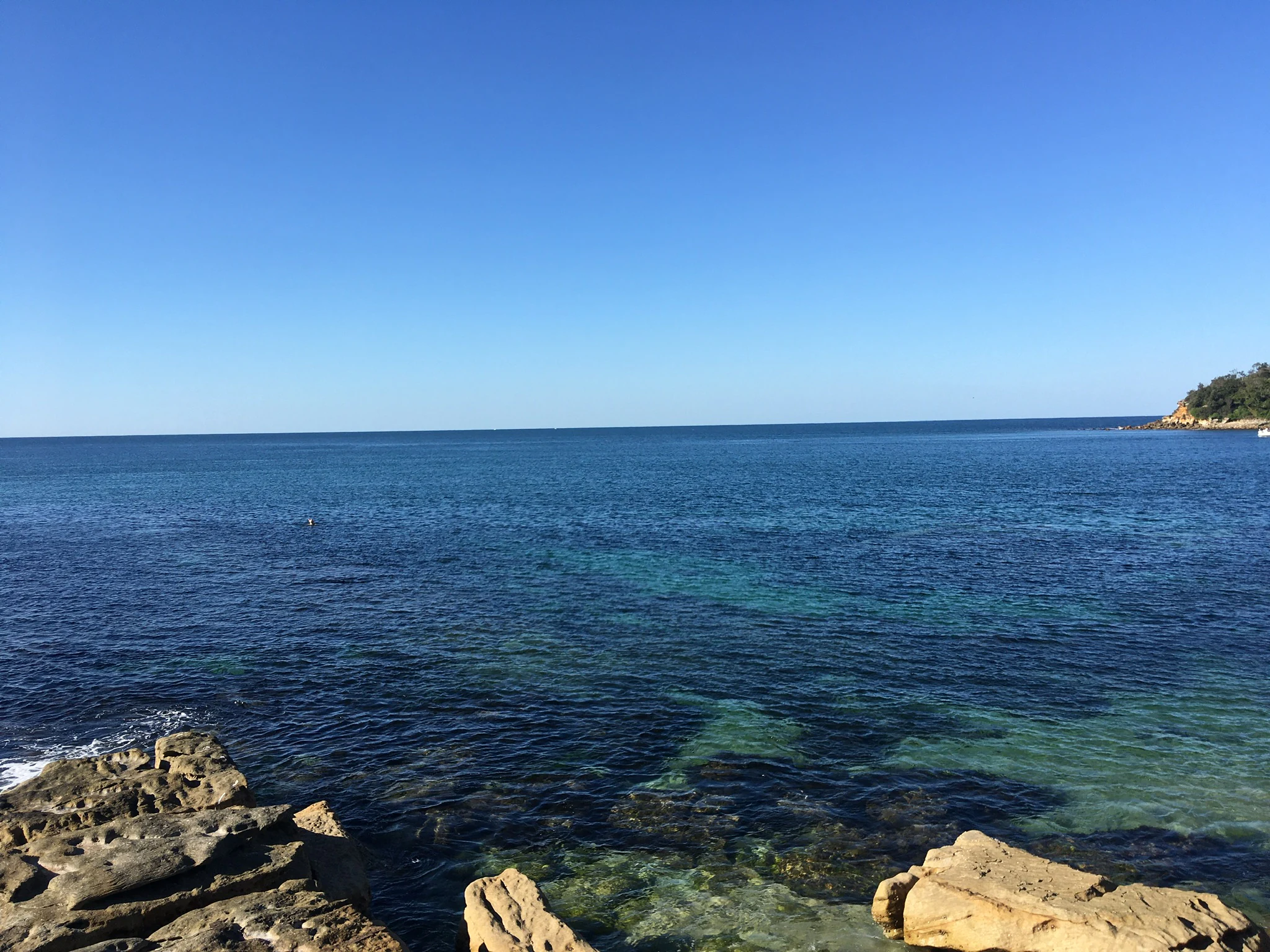
A wide view of a calm blue ocean bay with rocky foreground outcrops and a distant headland under a clear blue sky.
A view across the clear waters of Cabbage Tree Bay Aquatic Reserve.

Cabbage Tree Bay Aquatic Reserve history and protected-area timeline

The rocky shore of Cabbage Tree Bay was first given formal protection in 1993, when it was designated an Intertidal Protected Area under New South Wales marine conservation arrangements, recognizing its ecological value but limiting protection to the intertidal zone alone. For nearly a decade, the subtidal reefs, seagrass, and kelp communities just offshore remained outside the protected boundary.

In 2002 the New South Wales government expanded and upgraded this protection by proclaiming the full aquatic reserve, gazetted on 31 March 2002. The new designation replaced the older intertidal classification and brought the full subtidal environment under a comprehensive no-take framework, prohibiting fishing and the removal or disturbance of marine plants and animals, including dead material. The marine reserve is administered by the New South Wales Department of Primary Industries, which continues to manage the site as one of a small network of formally protected marine areas along the state's coast. The reserve's listing as an IUCN Category II protected area in the World Database on Protected Areas has helped place this local Sydney site within the global system of recognized protected-area categories.

Cabbage Tree Bay Aquatic Reserve landscape and geographic character

Although Cabbage Tree Bay Aquatic Reserve is fundamentally a marine rather than terrestrial site, its underwater landscape is its defining feature. Within its small 17-hectare footprint, the seafloor transitions from open sandy beach in the east, through a band of rocky intertidal and subtidal reef along the southern side, into deeper areas supporting seagrass meadows and kelp forest. The reserve thus mirrors in miniature the broader habitat zonation of the New South Wales coast, where sand, rock, seagrass, and kelp commonly alternate along the same headland.

The reserve is set against the dramatic backdrop of North Head, the sandstone headland that forms the northern entrance to Sydney Harbour. The cliffs and slopes above the bay belong to the adjacent Sydney Harbour National Park, which extends south along the harbor shoreline and protects the terrestrial complement to the marine reserve below. To the east, the coastline continues past Shelly Beach and the Shelly Beach Headland Intertidal Protected Area, while Manly Beach curves away to the northwest. Together, these surrounding features frame Cabbage Tree Bay as a small protected pocket within a much larger and still largely natural coastal landscape.

This combination of small spatial extent and high habitat variability gives the reserve a compact but visually rich underwater scenery, with sandy patches interspersed among rocky outcrops, swaying kelp, and seagrass beds. Divers and snorkelers can experience rapid transitions in landscape character within a single short swim, which is one of the reasons the site has become a focal point for marine interpretation in the Sydney region.

Cabbage Tree Bay Aquatic Reserve ecosystems, habitats, and plant life

The ecological identity of Cabbage Tree Bay Aquatic Reserve lies in the unusually tight packing of marine habitats within its 17-hectare boundary. Sandy substrate near the eastern beach gives way to a rocky intertidal and subtidal zone dominated by boulders and reef structures, while larger beds of seagrass and marine algae, including kelp, occupy the deeper subtidal areas. Together these habitats form a mosaic that supports a diverse mix of fish, invertebrate, and algal species typical of warm-temperate New South Wales waters.

A standout feature of the reserve's ecology is the small colony of the hard coral Pocillopora aliciae found within the bay. This coral is normally associated with tropical waters further north, and its presence here has been interpreted as evidence of climate-driven southward range shifts associated with warming seas. The reserve therefore functions not only as a refuge for resident species but also as a living record of changing marine biogeography along the east Australian coast.

Seagrass meadows within the reserve contribute to sediment stabilization, provide nursery habitat for juvenile fish, and support grazing invertebrates, while kelp forests offer three-dimensional structure used by predatory and prey species alike. The combination of these habitats in close proximity means that ecological processes normally spread across many kilometers of coast, such as the interaction between reef, sand, and algal habitats, can be observed in a single small protected area. The reserve's no-take protection amplifies these ecological roles by allowing populations to develop with minimal direct human removal.

Cabbage Tree Bay Aquatic Reserve wildlife and species highlights

The reserve supports a remarkably diverse fish fauna for its size, with more than 160 species recorded across its reefs, sand patches, and kelp areas. Common residents of the rocky reefs near Fairy Bower and the southern side of the bay include Achoerodus viridis, the eastern blue groper, a giant wrasse in which females are brown to reddish-brown and larger individuals change sex to become bright blue males, especially when groups lack males. This species is emblematic of Sydney's marine life and thrives in the reserve due to the absence of fishing pressure.

Another characteristic reef fish of the reserve is the long green wrasse, Pseudojuloides elongatus, a species with an unusually disjunct subtropical to temperate distribution spanning southwestern Western Australia, southern Japan, and the southwest Pacific. Its occurrence at Cabbage Tree Bay highlights the reserve's connections with other temperate reef systems beyond the immediate Sydney region. In addition to these residents, the bay receives seasonal visits from tropical species whose larvae drift south with the East Australian Current; the halterfish is one example, appearing in the bay during spring and summer as part of this annual tropical influx.

Marine invertebrate life is also significant, with roughly 50 species recorded. Among these, the colorful nudibranch Goniobranchus splendidus, a star snail, has been documented in the reserve and is part of a broader pattern of diverse subtropical invertebrate assemblages along the New South Wales coast. The mix of resident temperate species, seasonal tropical visitors, and a small tropical coral colony gives Cabbage Tree Bay a wildlife profile that is unusually rich for an urban marine reserve.

Cabbage Tree Bay Aquatic Reserve conservation status and protection priorities

The conservation significance of Cabbage Tree Bay Aquatic Reserve rests primarily on its strict no-take status, which provides a refuge from fishing and collecting pressure for reef fish, invertebrates, and habitat-forming algae and seagrass. By protecting the full suite of habitats from the intertidal into the subtidal, the reserve supports ecosystem processes such as predation, herbivory, and recruitment of juvenile fish, which in turn sustain the broader Sydney marine environment beyond its small boundary.

The reserve's recognition as an IUCN Category II protected area in the World Database on Protected Areas places it in the same protection category as national parks, indicating a high level of conservation commitment. Its place within a network of complementary protections, including the Shelly Beach Headland Intertidal Protected Area to the east and Sydney Harbour National Park to the south, reinforces its role as a node in a wider system of conserved coastal and marine environments along the North Head-Sydney Harbour corridor.

Its documented population of the hard coral Pocillopora aliciae, far south of the species' usual range, adds a conservation-relevant dimension to the reserve: it serves as a real-world example of how warming seas are reshaping marine communities, and as a baseline against which future changes in Sydney's reef biodiversity can be measured. In this sense the reserve functions as both a refuge and a long-term ecological monitoring site for climate-driven change along the New South Wales coast.

Cabbage Tree Bay Aquatic Reserve cultural meaning and human context

While Cabbage Tree Bay itself is a modern marine conservation designation, its setting carries strong cultural weight as part of Manly and the broader North Head-Sydney Harbour landscape. The adjacent sandstone headland of North Head, protected within Sydney Harbour National Park, has long been a defining landmark of Sydney's harbor entrance and is associated with Quaternary-era Aboriginal cultural heritage, defense-era history, and Sydney's twentieth-century identity as a beachside city.

Manly Beach, which lies just outside the reserve, is one of Australia's most recognizable beaches, famous as the place where surf lifesaving culture took early root and where ocean swimming became a defining part of Sydney's coastal recreation. The aquatic reserve sits within this wider cultural frame of Sydney beach culture, and its accessibility from one of the country's most visited beaches gives it an unusually strong cultural connection with everyday Sydneysiders. The reserve has also become part of the local marine educational tradition, frequently used in dive briefings, school programs, and citizen-science activities that link the wider Manly community to its nearshore marine environment.

Top sights and standout views in Cabbage Tree Bay Aquatic Reserve

Within only 17 hectares, Cabbage Tree Bay Aquatic Reserve combines sandy beach, rocky shore, rocky reef, seagrass meadow, and kelp forest, packing the classic warm-temperate New South Wales marine habitat zonation into a single no-take boundary. Its strict fishing prohibition has produced thriving populations of iconic Sydney reef fish such as the eastern blue groper and long green wrasse, while seasonal tropical visitors carried south by the East Australian Current add an unexpected Indo-Pacific influence to the resident fauna.

The reserve's most distinctive highlight is its small colony of the tropical hard coral Pocillopora aliciae, one of the southernmost recorded populations of this species and a tangible indicator of warming seas on a heavily urbanized coastline. Surrounded by Manly Beach, Shelly Beach, the Shelly Beach Headland Intertidal Protected Area, and Sydney Harbour National Park, the reserve sits at the heart of a remarkably complete coastal-protection corridor right on the edge of central Sydney.

Best time to visit Cabbage Tree Bay Aquatic Reserve

As a marine reserve rather than a large terrestrial park, Cabbage Tree Bay is best appreciated in the warmer months of the Sydney calendar, when calmer seas, longer daylight hours, and warmer water improve conditions for snorkeling and scuba diving along the reefs, seagrass, and kelp within the reserve. Late spring through summer is also the season when tropical visitors such as juvenile halterfish most often appear, carried south along the New South Wales coast by the East Australian Current, adding to the diversity of species divers can encounter.

Autumn and early winter can still offer excellent visibility and reduced crowds, although water temperatures drop and weather windows become more variable. Winter months are the least favorable for casual water-based enjoyment, although they remain a useful time for studying the reserve's temperate resident species and its coral population, which is of particular scientific interest as a warm-water outlier. In all seasons, calm weather days with low swell offer the most rewarding visits, since the reserve's underwater scenery is most visible when surface conditions are quiet.

Monthly climate preview

Long-term representative temperature and precipitation averages for New South Wales

Cabbage Tree Bay Aquatic Reserve Climate Normals and Annual Weather Patterns

Representative coordinate records show measured monthly temperature variations and precipitation averages across the protected area from 1991 through 2020. Reviewing the complete twelve-month climatology dataset provides deeper context regarding long-term environmental patterns at this location.
Annual mean18 °C
14 °C23 °C
Jan23°
Feb23°
Mar22°
Apr20°
May17°
Jun15°
Jul14°
Aug14°
Sep16°
Oct18°
Nov20°
Dec21°
Warmest month
January

22.7 °C

Coolest month
July

13.8 °C

Wettest month
February

4.4 mm/day

Driest month
July

1.6 mm/day

Park location guide

Geography guide, regional context, and park location map for Cabbage Tree Bay Aquatic Reserve

Cabbage Tree Bay Aquatic Reserve park geography, regions, and map view in Australia

Understand where Cabbage Tree Bay Aquatic Reserve sits in Australia through a broader geographic reading of the surrounding landscape, nearby location context, and its mapped position within the national park landscape.

How Cabbage Tree Bay Aquatic Reserve fits into Australia

Australia is a constitutional monarchy and federal parliamentary democracy comprising six states and ten territories. With a population of nearly 28 million, it is one of the world's most urbanised countries, with most people concentrated on the eastern seaboard. The country has a high Human Development Index and is known for its cultural diversity, ancient Aboriginal heritage, and unique wildlife.

Wider geography shaping Cabbage Tree Bay Aquatic Reserve in Australia

Australia occupies the entire Australian continent, the island of Tasmania, and numerous smaller islands. It is the world's flattest and driest inhabited continent, featuring vast deserts in the interior (the Outback), tropical rainforests along the eastern coast, and a coastline bordering the Indian and Pacific Oceans.

Map view of Cabbage Tree Bay Aquatic Reserve

Use this park location map to pinpoint Cabbage Tree Bay Aquatic Reserve in Australia, understand its exact geographic position, and read its mapped placement within the surrounding landscape more clearly.

Pigeon | © OpenStreetMap contributors

Location context for Cabbage Tree Bay Aquatic Reserve

New South Wales

Visual reference of subtidal reefs, kelp forests, and protected marine habitats

Cabbage Tree Bay Aquatic Reserve Photos and Mapped Coastal Landscape Scenery

Visual documentation of Cabbage Tree Bay Aquatic Reserve reveals the compact marine topography and diverse underwater habitats packed into this urban coastal sanctuary. Examining protected area imagery provides a clear understanding of the shifting reef ecosystems, rocky shores, and sheltered coastal environments.

A wide view of a calm blue ocean bay with rocky foreground outcrops and a distant headland under a clear blue sky.

Park atlas

Compare nearby protected areas and connected coastal landscapes across the Sydney region

Exploring Other Parks Near Cabbage Tree Bay Aquatic Reserve and Surrounding Coastal Reserves

Browsing other protected areas near Cabbage Tree Bay Aquatic Reserve reveals a rich network of coastal habitats, headlands, and marine reserves along the New South Wales coastline. Comparing these adjacent natural spaces provides valuable geographic context on regional marine zonation and urban conservation corridors.
National parkNew South Wales
0.2 km away#1 closest

Northwest

Sydney Harbour National Park: A Distinctive Coastal Protected Landscape in New South Wales

Explore its mapped geography and unique heritage sites.

Sydney Harbour National Park represents an extraordinary protected area in New South Wales, Australia, celebrated for its integration of natural coastal terrain with significant historical sites. This national park offers a unique opportunity for atlas-based exploration of its mapped boundaries, dramatic sandstone headlands, and sheltered harbour locations. Discover the distinctive blend of natural landscape and heritage fortifications that define this metropolitan park, providing a rich geographic context for understanding urban protected areas.

Area
3.92 km²
Established
1975
IUCN
II
Relief
Upland
National parkNew South Wales
5 km away#2 closest

Northwest

Garigal National Park: National Park Protected Landscape and Geographic Exploration

Mapped boundaries and regional natural terrain context in New South Wales.

Garigal National Park is a designated national park offering a specific focus for geographic and protected-area exploration. This detail page provides an atlas-oriented view of its mapped natural landscape and its role within the broader protected areas of New South Wales. Understand the park's identity through its geographic features and protected boundaries, enabling structured discovery of its unique landscape context.

Area
22.02 km²
Established
1991
IUCN
II
Relief
Mixed relief
Watercolor illustration of a river landscape with trees and vegetation
National parkNew South Wales
12 km away#3 closest

West

Lane Cove National Park: A Suburban National Park within New South Wales

Mapped bushland, river ecosystems, and diverse vegetation.

Lane Cove National Park presents a remarkable example of protected natural landscape persisting within metropolitan Sydney, New South Wales. This 670-hectare national park preserves varied ecosystems from sclerophyll forest to mangroves along the Lane Cove River. Its geographic position provides a unique atlas context, highlighting urban wilderness and ecological diversity within the Sydney region.

Area
6.7 km²
Established
1938
IUCN
V
Relief
Lowland
National parkNew South Wales
13 km away#4 closest

North

Ku-ring-gai Chase National Park: Hawkesbury Sandstone Protected Landscape and Ria Coastline

New South Wales National Park with mapped Aboriginal heritage.

Ku-ring-gai Chase National Park in New South Wales is renowned for its striking Hawkesbury Sandstone geology, defining its rugged plateau and steep, flooded ria valleys that shape a dramatic coastline. As Australia's third oldest national park, it preserves over 800 Aboriginal heritage sites, including rock engravings and art, set within a landscape perfect for geographic exploration and understanding protected areas. Examine its unique mapped terrain, from volcanic intrusions to tessellated pavements, all contributing to its distinct protected landscape identity.

Area
149.77 km²
Established
1894
IUCN
II
Visitors
2M annual
National parkAustralia
About 18 km away#5 closest

South

Malabar Headland National Park: Protected Landscape and Geographic Context in Australia

Explore the mapped terrain and natural geography of this Australian national park.

Delve into the geographic identity of Malabar Headland National Park, a designated national park in Australia. This resource provides critical atlas-level information, focusing on its protected landscape features, mapped boundaries, and position within Australia's broader natural geography. Understand the core elements that contribute to its significance as a conservation area, ideal for landscape context and regional geographic exploration.

National parkNew South Wales
21 km away#6 closest

South

Kamay Botany Bay National Park: National Park Geography and Protected Landscape Atlas

Mapped protected areas and natural terrain in New South Wales.

Kamay Botany Bay National Park offers a unique window into Australia's protected natural areas. This entry focuses on its identity as a national park, detailing its geographic position within New South Wales and the mapped context of its protected boundaries. Gain insight into the park's landscape features and its significance within a broader atlas of conservation lands, facilitating a structured approach to understanding its unique natural terrain.

Area
4.56 km²
Established
1984
IUCN
V
Relief
Mixed relief
National parkNew South Wales
22 km away#7 closest

Northwest

Berowra Valley National Park: A National Park in New South Wales with Detailed Geographic Mapping

Explore its mapped boundaries and regional landscape context.

Delve into Berowra Valley National Park, a protected area situated in New South Wales, Australia. This entry provides essential geographic context, focusing on its mapped boundaries and the specific natural landscape it encompasses. It serves as a key resource for understanding the park's role within the broader regional atlas and its distinct protected terrain.

Area
38.84 km²
Established
2012
IUCN
II
Relief
Upland
Regional parkNew South Wales
About 25 km away#8 closest

Northwest

Berowra Valley Regional Park: Protected Bushland Geography in Northern Sydney

A vital sandstone corridor and nature reserve within New South Wales

Berowra Valley Regional Park acts as a key element of the Berowra Creek valley system, offering a protected bushland refuge amidst the suburbs of Hornsby Shire. Characterized by steep ridges, sheltered gullies, and native forest, the park functions as a bridge within a larger network of near-coastal reserves that define the natural terrain of northern Sydney.

Area
0.087 km²
Established
1998
IUCN
V
Scope
Terrestrial

Common questions about visiting, size, designation, and location context for Cabbage Tree Bay Aquatic Reserve

Cabbage Tree Bay Aquatic Reserve FAQs for park facts, access, geography, and protected area context

Find quick answers about Cabbage Tree Bay Aquatic Reserve, including protected-area facts, park geography, trail and visitor context, and how the park fits into its surrounding country and regional landscape.
MoriAtlas Explorer

Continue Your Protected Areas Search Across the Global Atlas

Deepen your exploration by continuing the structured search for national parks and protected areas worldwide. Utilize the comprehensive filtering capabilities to compare different conservation landscapes and refine your understanding of global park geography. Discover more about the distribution and characteristics of protected natural areas.

Global natural geography