
Mori Atlas logo
Biosphere reserveCape Floristic Region

Mapping the Mediterranean shrublands, endemic biodiversity, and mountain terrain of the Western Cape

Cape Floristic Region: A Comprehensive Geographic Atlas of South Africa Protected Landscapes

(Cape Floral Region Protected Areas)

The Cape Floristic Region represents one of the world's most botanically concentrated floral kingdoms, encompassing a unique mosaic of fynbos, renosterveld, and coastal scrub. Stretching across the Western Cape, this protected biosphere reserve features rugged mountain ranges and Mediterranean climate patterns that underpin extraordinary levels of plant endemism. Explore the mapped boundaries and natural terrain of this region to understand its role as a vital global biodiversity hotspot.

floristic regionfynbos biomeMediterranean shrublandbiodiversity hotspotWorld Heritage Siteendemic plants
A flat-style digital illustration of a desert scene with a prominent central mountain, cacti in the foreground, and a bright sun in the blue sky.

Cape Floristic Region

Biosphere reserve

Park overview

Structured park overview, official facts, and landscape profile for Cape Floristic Region

Cape Floristic Region park facts, protected area profile, and essential visitor context

Review the core facts for Cape Floristic Region, including designation, size, terrain, visitor scale, habitats, and operating context in one park-focused overview.

About Cape Floristic Region

The Cape Floristic Region defines a globally distinct botanical landscape at the southwestern corner of the African continent. It is not a single park or reserve but a sweeping floristic region that anchors the Cape Floristic Kingdom, the smallest of the world's six floral kingdoms by area yet unmatched in vascular plant diversity per unit area. Within South Africa, it occupies the Mediterranean-climate zone of the Western Cape and extends eastward into parts of the Eastern Cape where rainfall patterns shift.

The region's defining biome is fynbos, a sclerophyllous, evergreen shrubland whose character is shaped by recurrent fire cycles, acidic sandy soils, and modest but seasonally reliable rainfall. Fynbos vegetation is dominated by three plant groups that give the biome its distinctive structure: proteas (Proteaceae), heaths (Ericaceae), and reed-like restios (Restionaceae). Beyond fynbos, the region also encompasses sandveld along the western coast, renosterveld on base-rich shaley lowland soils, and small, sheltered pockets of Southern Afrotemperate Forest in moist valleys and ravines.

The botanical significance of the region is exceptional. Five of South Africa's twelve endemic plant families are restricted to this area, alongside roughly 160 endemic genera. The region's unique assembly of endemics arises from a combination of ancient soils, varied topography, Mediterranean climate seasonality, and the regenerative role of fire. As a result, the Cape Floristic Region has become an essential reference point for understanding Mediterranean-climate shrublands worldwide and is frequently studied alongside the shrublands of California, the Mediterranean Basin, Chile, and southwestern Australia.

Today, the Cape Floristic Region is recognized internationally through two intersecting designations: UNESCO's Cape Floral Region Protected Areas World Heritage Site, inscribed in 2004 and extended in 2015, and Conservation International's designation of the area as a biodiversity hotspot. The protected-area framework built around the region incorporates a network of national parks, wilderness areas, nature reserves, and mountain complexes spread across the Western Cape.

Quick facts and research context for Cape Floristic Region

The Cape Floristic Region lies entirely within South Africa, stretching across the Western Cape and into the eastern reaches of the Eastern Cape. It spans approximately 78,555 square kilometres and operates under a Mediterranean climate regime in the west, transitioning eastward toward summer-rainfall conditions.

The region is recognized as a UNESCO World Heritage Site under the name "Cape Floral Region Protected Areas," inscribed in 2004 and extended in 2015. It is also classified as a biodiversity hotspot by Conservation International, and its fynbos ecoregions are listed among the World Wide Fund for Nature's Global 200 priority ecoregions. The region supports more than 9,000 vascular plant species, with a majority of vascular plant species being endemic to the region.

Protection and recognition

Documented protected area designation and official UNESCO world heritage records

Cape Floristic Region Protection Status and International Recognition Data

Cape Floristic Region protection status data compiles official international recognition records and designated conservation frameworks. Documented UNESCO world heritage details provide structural context for the protected area landscape.
Park context

Deeper park guide and search-rich context for Cape Floristic Region

Cape Floristic Region history, landscape, wildlife, and travel context

Explore Cape Floristic Region through its history, landscape character, ecosystems, wildlife, conservation priorities, cultural context, and seasonal travel timing in a structured park guide built for atlas discovery and search intent.

Why Cape Floristic Region stands out

The Cape Floristic Region is most renowned for its extraordinary plant diversity within a small geographic footprint, hosting over 9,000 vascular plant species, with roughly 69% of those species being endemic. This concentration of endemic life makes it the only hotspot that encompasses an entire floral kingdom, and identifies it as one of the five Mediterranean-climate regions recognised globally as a biodiversity hotspot. Its botanical identity is inseparable from fynbos, a fire-adapted shrubland defined by proteas, ericas, and restios, growing on the acidic, nutrient-poor soils derived from Table Mountain sandstones. Equally distinctive is renosterveld, a grassy shrubland of daisy-family dominated flora on richer shaley lowlands. Together these vegetation types host many endemic genera and families found nowhere else on the planet, including members of the Grubbiaceae, Roridulaceae, Bruniaceae, Penaeaceae, and Greyiaceae.
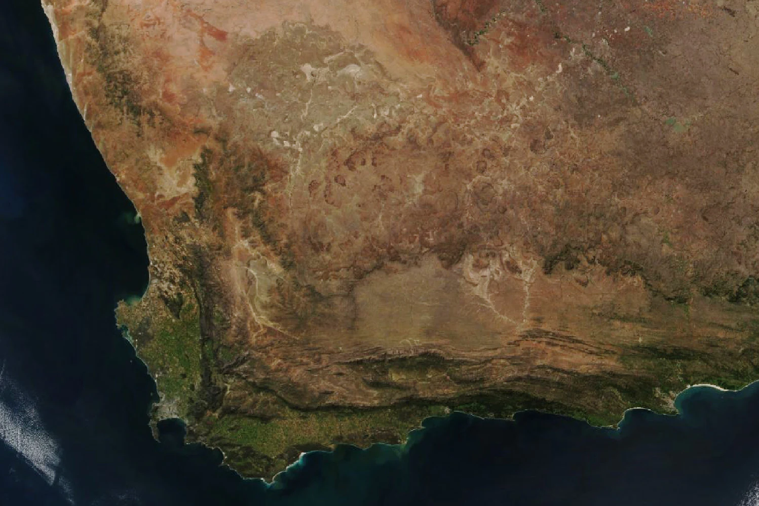
Top-down satellite view of the southwestern tip of South Africa, showing the coastline, mountainous terrain, and vegetation patterns of the Cape Floristic Region.
Satellite view of the Cape Floristic Region in South Africa.

Cape Floristic Region history and protected-area timeline

The Cape Floristic Region's recognition as a globally significant botanical area developed over decades of scientific study, but its formal international protection began in 2004 when UNESCO inscribed the "Cape Floral Region Protected Areas" as a World Heritage Site under natural criteria (ix) and (x). The inscription brought together eight representative protected areas under a single serial nomination, including Table Mountain National Park, the Cederberg Wilderness Area, the Groot Winterhoek Wilderness Area, the Boland Mountain Complex, De Hoop Nature Reserve, the Boosmansbos Wilderness Area, the Swartberg Complex, and the Baviaanskloof Mega Reserve. The site was extended in 2015 to broaden its coverage and strengthen the coherence of the network.

Conservation South Africa, an outgrowth of Conservation International's earlier South Africa programme, engaged in conservation activities within parts of the Cape Floristic Region in the early 2000s, contributing to the groundwork that supported the World Heritage nomination. By that time, the World Wide Fund for Nature had already categorized the area's fynbos ecoregions among its Global 200 priority ecoregions for conservation, underlying the region's importance in global biodiversity strategies.

Cape Floristic Region landscape and geographic character

The landscape of the Cape Floristic Region is defined by the meeting of mountains, coast, and Mediterranean climate. Much of the terrain is folded into the Cape Fold Belt mountains, whose sandstone ridges, such as Table Mountain, the Cederberg, the Hottentots Holland range, the Groot Winterhoek, and the Swartberg, rise sharply above adjacent lowlands and form the dominant backdrop of the region. These mountains are built largely from Table Mountain Group sandstones, whose weathered, acidic, nutrient-poor soils underpin the fynbos biome.

Between the mountains lie broader lowlands and coastal forelands. The western coastal belt features soft sandy scrubland in the sandveld, while the interior lowlands hold shaley soils that support renosterveld grassy shrubland. The coastline itself alternates between rugged cliffed sections where mountains meet the sea and gently undulating sandy shores, with De Hoop Nature Reserve protecting an especially notable coastal-lagoon section.

Hydrographically, the region is shaped by seasonal rainfall that flows in winter in the west and shifts toward more year-round and summer-rainfall patterns further east, creating gradients that influence vegetation patterns across the landscape. The Mediterranean climate interaction with fire and sandstone terrain produces a mosaic of regenerating shrublands, with areas such as the Groot Winterhoek showing fresh post-fire regrowth on visibly pale, infertile soils.
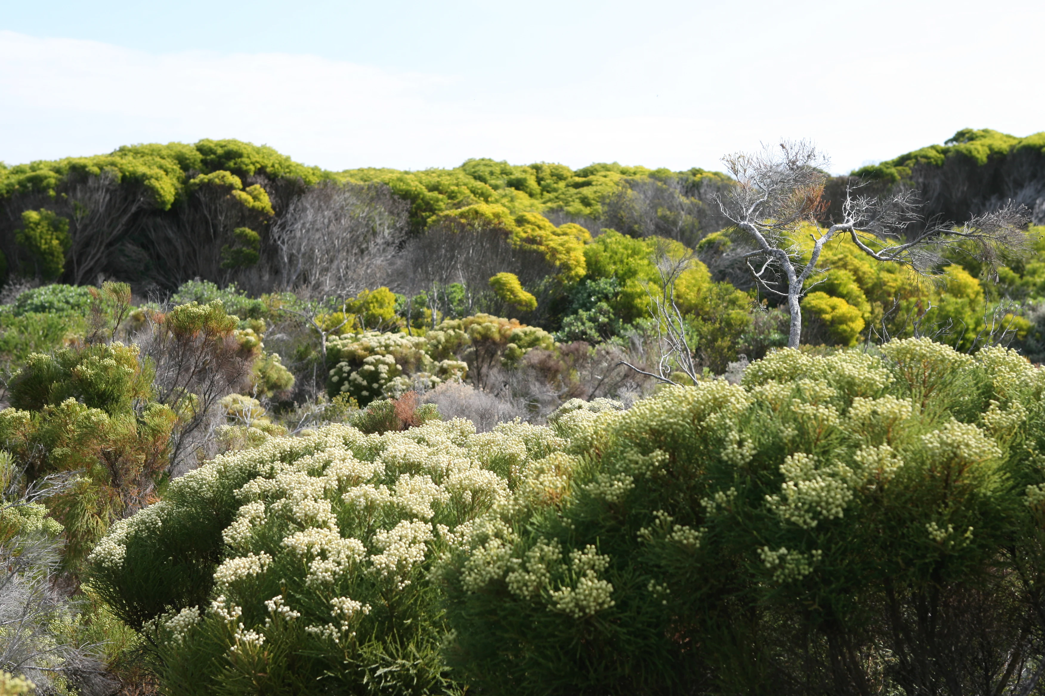
A landscape shot of dense, diverse fynbos vegetation with light-colored flowering shrubs in the foreground and a backdrop of green, shrubby hills.
Fynbos vegetation at the Cape Peninsula, characteristic of the Cape Floristic Region.

Cape Floristic Region ecosystems, habitats, and plant life

Ecologically, the Cape Floristic Region is shaped by a Mediterranean climate system with winter rainfall in its western areas, gradually shifting east toward transitional and summer-rainfall regimes. This climatic gradient, combined with sharp topographic variation across the Cape Fold Belt, drives the differentiation of vegetation into multiple distinct types. The World Wide Fund for Nature divides the region into three ecoregions: Lowland fynbos and renosterveld, Montane fynbos and renosterveld, and Albany thickets.

The principal vegetation type is fynbos, a sclerophyllous evergreen shrubland of fine-leaved plants growing on acid sands or nutrient-poor sandstone-derived substrates. Fynbos is renowned for its high species turnover across short distances and its dependence on periodic fire cycles that trigger mass regeneration, seed germination, and nutrient cycling. Where soils become richer and more shaley, fynbos gives way to renosterveld, a grassy shrubland dominated by Asteraceae, graminoids, and geophytes. Sandy coastal sections support sandveld scrubland, while sheltered, humid ravines harbor pockets of Southern Afrotemperate Forest.

The region also includes numerous narrowly endemic vegetation types, from Cape Flats Dune Strandveld on urban-coastal edges to Hangklip Sand Fynbos, Kogelberg Sandstone Fynbos, Boland Granite Fynbos, and Peninsula Granite Fynbos. Together, these types illustrate how geology, soil, and microclimate produce an unexpectedly fragmented mosaic of plant communities concentrated in a small geographic area.
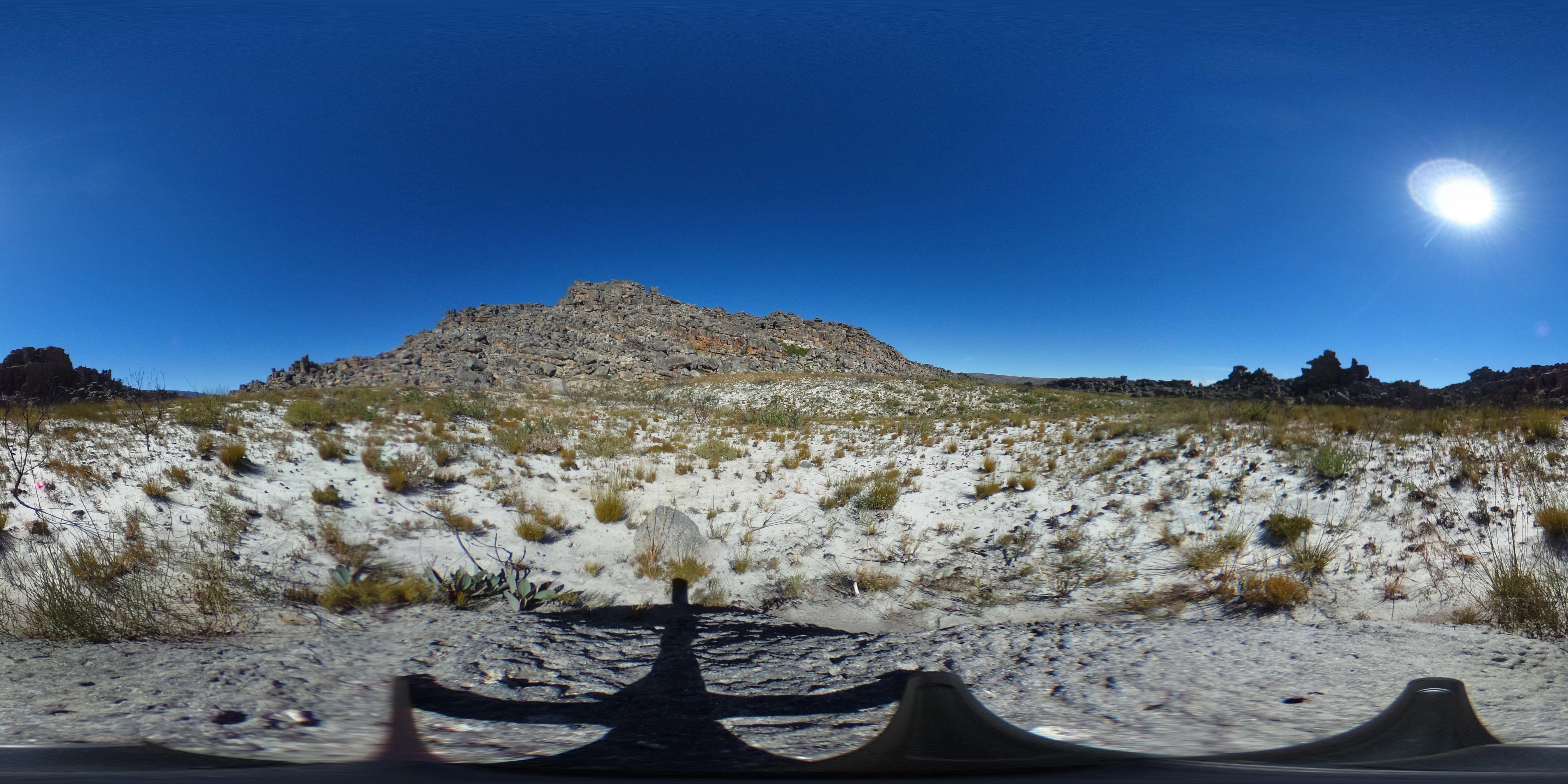
A wide, panoramic, 360-degree view showing sandy, rocky terrain with low-growing fynbos vegetation sprouting after a fire, under a bright blue sky with a visible sun.
Post-fire fynbos vegetation regeneration in the Groot Winterhoek region, 18 months after a fire event.

Cape Floristic Region wildlife and species highlights

The Cape Floristic Region is primarily defined by its plant life rather than its vertebrate fauna, and its ecological significance rests on botanical diversity and endemism rather than iconic large mammals. The region's faunal communities are characteristic of southwestern Africa's fynbos, renosterveld, and afromontane forest environments.

Rodents, small carnivores, reptiles, and an array of endemic insects occupy the fynbos shrublands, where seasonal flowering events support a rich community of pollinators. Birdlife includes fynbos specialists and species associated with coastal scrub, lowland renosterveld, and afromontane forest patches. The presence of endemic plant groups such as proteas also supports specialist interactions with nectar-feeding birds and insects tied to seasonal flowering cycles.

Cape Floristic Region conservation status and protection priorities

The Cape Floristic Region holds globally recognized conservation status through multiple overlapping frameworks. It is a UNESCO World Heritage Site under natural criteria relating to ecological processes and biodiversity, and at the same time it is classified as a biodiversity hotspot by Conservation International, indicating both exceptional endemism and significant habitat threat. Its fynbos ecoregions are also listed among the World Wide Fund for Nature's Global 200 priority ecoregions for conservation.

Despite this recognition, the region is considered to be experiencing one of the most rapid rates of extinction globally due to ongoing pressures including habitat loss, land degradation, and the spread of invasive alien plants. The serial World Heritage designation, incorporating eight representative protected areas across the Western and Eastern Cape, functions as one of the principal international instruments attempting to maintain the integrity of fynbos and related vegetation types in the long term.

Cape Floristic Region cultural meaning and human context

The cultural context of the Cape Floristic Region is rooted in the deep agricultural and economic relationship South African communities have developed with fynbos ecosystems. The harvest and cultivation of fynbos products, including wildflowers, forms the basis of a regional economy tied directly to the unique flora of the area. The eco-tourism sector similarly depends on the appeal of the region's botanical wealth.

The region is also a source of rooibos, a plant of cultural and economic importance traditionally harvested from the Cape fynbos landscape. The Western Cape wine industry operates in close geographical proximity to fynbos vegetation, with vineyards often situated within or adjacent to renosterveld and fynbos habitats, linking the region's botanical identity to broader regional land-use patterns.

Top sights and standout views in Cape Floristic Region

The Cape Floristic Region stands out as the only floral kingdom of its size within the global system of six floral kingdoms, and is one of only two hotspots encompassing an entire floral kingdom. It hosts over 9,000 vascular plant species with extremely high endemism, and supports five of South Africa's twelve endemic plant families and around 160 endemic genera.

Its ecological value is reinforced by its Mediterranean climate position, making it one of only five temperate Mediterranean-type systems on Conservation International's global hotspots list. The combination of botanic richness, multiple overlapping international protection designations, and a mosaic of fynbos, renosterveld, sandveld, and afromontane forest vegetation marks it as one of the most distinctive floristic regions on Earth.

Best time to visit Cape Floristic Region

The Mediterranean climate of the Cape Floristic Region concentrates rainfall in the winter months, particularly in the west, while summers are typically warm and dry. Spring, in particular, brings the region's wildflower displays into peak intensity, especially across fynbos landscapes where proteas, ericas, and a wide array of geophytes come into bloom against recently burned or regenerating slopes.

Visitors interested in seeing the characteristic post-fire regeneration of fynbos may find recently burned areas especially dramatic in the months following a fire, when fresh growth contrasts strikingly with the pale sandstone soils. Cooler, wetter winter months emphasize the green character of fynbos and afromontane forest patches, while summer months favor warmer coastal exploration and longer daylight periods across the broader region.
Monthly climate preview

Long-term monthly temperature averages and precipitation patterns for Western Cape

Cape Floristic Region Climate Normals, Annual Temperature and Precipitation Rhythm

Representative coordinate records show average monthly temperatures ranging from 14.27 to 20.3 degrees Celsius alongside recorded precipitation shifts across the year. Reviewing the complete monthly climate profile reveals detailed twelve-month normals for the protected landscape.
Annual mean17 °C
14 °C20 °C
Jan20°
Feb20°
Mar19°
Apr18°
May16°
Jun15°
Jul14°
Aug14°
Sep15°
Oct16°
Nov17°
Dec19°
Warmest month
February

20.3 °C

Coolest month
August

14.3 °C

Wettest month
June

2.8 mm/day

Driest month
February

0.4 mm/day

Park location guide

Geography guide, regional context, and park location map for Cape Floristic Region

Cape Floristic Region park geography, regions, and map view in South Africa

Understand where Cape Floristic Region sits in South Africa through a broader geographic reading of the surrounding landscape, nearby location context, and its mapped position within the national park landscape.

How Cape Floristic Region fits into South Africa

South Africa is the southernmost country in Africa, spanning 1.22 million km² with a population of over 63 million. The country operates with three capital cities, Pretoria (executive), Cape Town (legislative), and Bloemfontein (judicial), and is renowned for its biodiversity, national parks, and multicultural society.

Wider geography shaping Cape Floristic Region in South Africa

South Africa occupies the southernmost region of Africa, with coastline along both the Atlantic Ocean to the west and the Indian Ocean to the east. The interior features elevated plateaus including the Highveld, with the Drakensberg escarpment marking the eastern highlands. The country shares borders with Namibia, Botswana, Zimbabwe, Mozambique, Eswatini, and Lesotho.

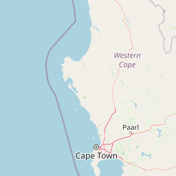
Map view of Cape Floristic Region

Use this park location map to pinpoint Cape Floristic Region in South Africa, understand its exact geographic position, and read its mapped placement within the surrounding landscape more clearly.

Pigeon | © OpenStreetMap contributors

Location context for Cape Floristic Region

Eastern CapeWestern Cape

Visualizing fynbos biomes, sandstone mountain terrain, and protected coastal habitats

Cape Floristic Region Photos and Landscape Scenery Exploration

Photographic collections reveal the complex terrain of sandstone mountain ridges, coastal lowlands, and diverse shrubland biomes across the Cape Floristic Region. Visual exploration helps observers examine the distinct plant habitats and protected landscape character that define one of the most botanically concentrated areas on Earth.

Top-down satellite view of the southwestern tip of South Africa, showing the coastline, mountainous terrain, and vegetation patterns of the Cape Floristic Region.

A landscape view featuring bright orange pincushion protea flowers in the foreground, with rolling green hills and a distant urban area visible in the background.

A landscape shot of dense, diverse fynbos vegetation with light-colored flowering shrubs in the foreground and a backdrop of green, shrubby hills.

A wide, panoramic, 360-degree view showing sandy, rocky terrain with low-growing fynbos vegetation sprouting after a fire, under a bright blue sky with a visible sun.

Park atlas

Compare surrounding regional geography and related conservation areas

Parks Near Cape Floristic Region and Connected Protected Landscapes

Browse protected areas near the surrounding region to compare adjacent fynbos biomes, mountain chains, and coastal reserves. Expanding the view beyond Cape Floristic Region provides deeper geographic context for regional plant diversity and Mediterranean shrublands.
National parkWestern Cape
Mapped location lies within the park boundary#1 closest

North

Table Mountain National Park: Mapped Protected Landscape and Geographic Context in Western Cape

National Park details focused on atlas exploration and regional geography.

Table Mountain National Park is a designated national park within the Western Cape region, offering a distinct geographic profile for atlas exploration. This entity provides detailed mapped boundaries and landscape context, crucial for understanding its role as a protected area in South Africa. Users can explore the specific geography that defines this park and its place within the broader regional context, making it a key point of interest for structured geographic discovery and map-based research.

Area
221 km²
Established
1998
Relief
Mountain
Climate
Mediterranean
Nature reserveCape Town
About 38 km away#2 closest

Northeast

Tygerberg Nature Reserve: Geographic Mapping of a Cape Town Protected Landscape

Renosterveld shale ridges and urban conservation context

Tygerberg Nature Reserve stands as a compact, high-value protected area within Cape Town, safeguarding hundreds of plant species and threatened Renosterveld habitats. The park landscape features a recognizable chain of shale hills punctuated by historic termite mounds known as heuweltjies, offering a window into the regional ecology and natural history of the Western Cape.

Area
3 km²
Established
1973
Relief
Upland
Climate
Mediterranean
A watercolor illustration of a wide landscape featuring a calm body of water in the foreground, rolling green hills, and purple-toned mountains in the background.
Nature reserveWestern Cape
About 51 km away#3 closest

East

Kogelberg Nature Reserve: Protected Mountain Geography in the Western Cape, South Africa

Coastal mountain fynbos and protected river ecosystems

Situated in the Western Cape of South Africa, Kogelberg Nature Reserve protects an exceptional concentration of fynbos vegetation and rugged sandstone terrain. The area spans coastal mountain ridges, riparian corridors, and forest-filled ravines, serving as a landmark for botanical diversity and protected-landscape mapping in the region.

Area
30 km²
Relief
Mountain
Scope
Terrestrial
Water
Major water bodies
Watercolor painting of a mountain landscape with green foreground hills and soft purple mountain ranges in the background.
Nature reserveWestern Cape
About 56 km away#4 closest

Northeast

Jonkershoek Nature Reserve: A Detailed Atlas of Mountain Catchment and Fynbos Ecology

Protected mountain geography near Stellenbosch, Western Cape

Jonkershoek Nature Reserve serves as a primary water source for the surrounding Western Cape landscape. This profile outlines the reserve's role in the Cape Floral Region, detailing its complex mountain topography, river headwaters, and significant fynbos plant communities that characterize the terrain.

Area
110 km²
Relief
Mountain
Climate
Mediterranean
Access
Easy access
Nature reserveWestern Cape
About 58 km away#5 closest

North

Koeberg Nature Reserve: A Geographical Overview of Coastal Protected Landscapes

Lowland fynbos, dune thicket, and aquifer geography in the Western Cape

Situated north of Cape Town, Koeberg Nature Reserve acts as a vital sanctuary for threatened plant communities and diverse bird populations. Its unique terrain combines sandy coastal dunes with seasonal pans and wetland complexes, providing a distinct study in protected area conservation and regional ecological management.

Area
26.81 km²
Established
1991
Relief
Lowland
Climate
Mediterranean
Biosphere reserveWestern Cape
About 74 km away#6 closest

Northeast

Cape Winelands Biosphere Reserve: Geographic Overview and Protected Area Mapping

Western Cape mountain terrain and sustainable landscape integration

The Cape Winelands Biosphere Reserve serves as a model for integrated landscape management in South Africa. Situated along the Cape Fold Belt, this reserve protects crucial water catchments and endemic floral habitats while encompassing a globally recognized wine-producing region. Access detailed mapping of its core, buffer, and transition zones to see how conservation persists within a working agricultural environment.

Area
1,243.4 km²
Established
2007
Relief
Mountain
Climate
Mediterranean
A watercolor painting showing a soft, panoramic landscape with green hills in the background, a body of water in the middle ground, and grasses in the foreground.
Nature reserveWestern Cape
About 85 km away#7 closest

North

Dassen Island Nature Reserve: Atlantic Geography and Protected Area Overview

Coastal refuge and protected granite-based Atlantic island

Located in the cold waters off the Western Cape, Dassen Island is a proclaimed nature reserve and Ramsar wetland. This flat Atlantic landmass is characterized by its granitic reef structure and long-established role as a sanctuary for African penguins and other seabird populations. The island represents a convergence of maritime history and marine conservation, offering a unique geographic perspective on South Africa's coastal wilderness.

Area
2.6 km²
Established
2019
Relief
Lowland
Climate
Mediterranean
National parkWestern Cape
About 96 km away#8 closest

North

West Coast National Park: A National Park's Mapped Boundaries and Geographic Identity

Explore its protected landscape within the Western Cape region.

West Coast National Park is a protected national park situated in the Western Cape province of South Africa. This dedicated page provides a structured view of its geographic scope, emphasizing its mapped boundaries and its significance as a protected landscape within the region's broader atlas context. Gain insight into the park's distinct natural terrain and regional geography.

Area
362.59 km²
Established
1985
Climate
Mediterranean
Access
Easy access

Common questions about visiting, size, designation, and location context for Cape Floristic Region

Cape Floristic Region FAQs for park facts, access, geography, and protected area context

Find quick answers about Cape Floristic Region, including protected-area facts, park geography, trail and visitor context, and how the park fits into its surrounding country and regional landscape.
MoriAtlas Explorer

Continue Your Protected Areas Search Across the Global Atlas

Deepen your exploration by continuing the structured search for national parks and protected areas worldwide. Utilize the comprehensive filtering capabilities to compare different conservation landscapes and refine your understanding of global park geography. Discover more about the distribution and characteristics of protected natural areas.

Global natural geography