Mori Atlas logo
Biosphere reserveCape Winelands Biosphere Reserve

Analyzing the intersection of Cape Fold Belt topography and sustainable agricultural land use patterns.

Cape Winelands Biosphere Reserve: A Detailed Atlas of Protected Mountain and Valley Landscapes

The Cape Winelands Biosphere Reserve represents a critical protected area within the Western Cape province of South Africa, spanning over three hundred thousand hectares. This territory integrates dramatic sandstone mountain ranges, deep valley basins, and unique Fynbos and Renosterveld vegetation. By examining the vertical gradient from valley floor to peak, you can understand how this reserve bridges biodiversity conservation with an internationally significant working viticultural landscape.

biosphere reserveUNESCO Man and the BiosphereCape Floral KingdomFynbosRenosterveldSucculent Karoo

Cape Winelands Biosphere Reserve

Biosphere reserve

Park overview

Structured park overview, official facts, and landscape profile for Cape Winelands Biosphere Reserve

Cape Winelands Biosphere Reserve park facts, protected area profile, and essential visitor context

Review the core facts for Cape Winelands Biosphere Reserve, including designation, size, terrain, visitor scale, habitats, and operating context in one park-focused overview.

About Cape Winelands Biosphere Reserve

The Cape Winelands Biosphere Reserve represents a deliberate effort to weave biodiversity protection into one of South Africa's most economically and culturally significant rural landscapes. Designated by UNESCO in 2007, the reserve stretches northeastward from the edge of the Kogelberg Biosphere Reserve in the south, following the spine of the Cape Fold Belt Mountains and dipping down into the valleys that form the heart of the Cape Winelands. Its location roughly forty kilometers east of Cape Town places it at the interface of major urban markets, intensive agriculture, and a globally important botanical kingdom.

Geographically, the reserve is defined by the dramatic contrast between rugged sandstone mountain ranges and fertile intermontane valleys. Elevations climb from about 20 meters at the lower valley floors to roughly 1,860 meters along the highest peaks, producing a steep environmental gradient that supports an exceptionally wide range of plant communities. The core mountain zones are dominated by Mountain Fynbos, with Sand Plain Fynbos and several types of Renosterveld, including Central Mountain Renosterveld and South and South-West Coast Renosterveld, occupying lower slopes and valley margins. Fragments of the Little Succulent Karoo also occur in drier parts of the landscape, adding further botanical diversity.

Culturally, the reserve includes one of the most recognizable wine-producing regions in the Southern Hemisphere. Vineyards, pastures, wheat fields, and commercial timber plantations intermingle with historic towns, hamlets, and farmsteads that together support a population of approximately 320,000 people. The built environment is strongly characterized by the Cape Dutch architectural vernacular, with whitewashed farmsteads and gabled homesteads framing the valleys and giving the region its distinctive cultural identity. At the same time, the reserve's mountain catchments supply high-quality water to the Cape West Coast and to the City of Cape Town, embedding the area in regional water security and infrastructure as well as agriculture.

Governance of the reserve is shared among the Cape Winelands District Municipality and several local municipalities, including Stellenbosch, Drakenstein, Breede Valley, Witzenberg, and Theewaterskloof, working together with CapeNature and other conservation bodies. The reserve is simultaneously a conservation instrument, a sustainable development framework, and a regional coordination platform, supporting research, stewardship, and land-care programs alongside the continued vitality of the wine, tourism, forestry, and broader agricultural economy.

Quick facts and research context for Cape Winelands Biosphere Reserve

The Cape Winelands Biosphere Reserve spans approximately 322,030 hectares in the Western Cape Province of South Africa, with elevations ranging from about 20 meters up to roughly 1,860 meters. Designated by UNESCO in 2007, the reserve includes 99,459 hectares of core area, 133,844 hectares of buffer zone, and 88,727 hectares of transition area, extending northward from the Kogelberg Biosphere Reserve along the Cape Fold Mountains.

The major ecosystem of the reserve is the Cape Floral Kingdom, with Mountain Fynbos and various forms of Renosterveld as the dominant vegetation types. The landscape combines natural features such as folded mountain ranges and valleys with a working cultural landscape of vineyards, pastures, wheat fields, and Cape Dutch architecture, and supports a population of more than three hundred thousand people across its towns, hamlets, and farmsteads.

Protection and recognition

Documented protection history, management scope, and official designation records

Cape Winelands Biosphere Reserve Protection Status and International Recognition

Cape Winelands Biosphere Reserve maintains documented protection status anchored by a designated year of 2007 and official UNESCO biosphere reserve recognition. Structured records bring together mixed protection parameters and international recognition sources to outline the administrative profile of the protected landscape.

International recognition

Protection details

Protection scope
Mixed
Designated year
2007
Transboundary protection
No
Core area
99,459 km²
Buffer area
133,844 km²
Park context

Deeper park guide and search-rich context for Cape Winelands Biosphere Reserve

Cape Winelands Biosphere Reserve history, landscape, wildlife, and travel context

Explore Cape Winelands Biosphere Reserve through its history, landscape character, ecosystems, wildlife, conservation priorities, cultural context, and seasonal travel timing in a structured park guide built for atlas discovery and search intent.

Why Cape Winelands Biosphere Reserve stands out

The reserve is best known for its position within the Cape Floral Kingdom, one of the most botanically diverse regions on Earth, and for the overlap between that exceptional natural heritage and the internationally recognized Cape Winelands viticultural landscape. It links protected Fynbos and Renosterveld habitats along the Cape Fold Belt Mountains with a culturally rich valley landscape of vineyards, historic estates, and Cape Dutch architecture. It is also recognized for incorporating key sections of the Cape Floral Region Protected Areas World Heritage Site and for functioning as a critical water source area for the Western Cape, supplying runoff from its mountain catchments to agriculture, the Cape West Coast, and the City of Cape Town. The combination of endangered vegetation types, working agricultural landscapes, and major research institutions has made it an influential testing ground for biodiversity-friendly wine production and landscape-scale conservation in South Africa.

Cape Winelands Biosphere Reserve history and protected-area timeline

The Cape Winelands Biosphere Reserve was formally designated in 2007, recognizing the long-standing biological and cultural importance of the Cape Winelands landscape and its position within the Cape Floral Kingdom. Its establishment built directly on South Africa's broader efforts to consolidate protection around the Cape Floral Region Protected Areas World Heritage Site, parts of which lie within the reserve's boundaries.

The reserve's design reflects a deliberate strategy to combine ecological protection with a working agricultural and human landscape that has existed for centuries. Historic Cape Dutch farmsteads, longstanding vineyards, and established towns such as Stellenbosch, Paarl, Franschhoek, and others in the broader Winelands region were already central to the regional identity when the reserve was designated. Rather than removing people from the landscape, the biosphere framework formalized a system in which core conservation areas, buffer zones, and transition areas work together to accommodate existing land uses while strengthening protection for endangered vegetation and water supply.

Since designation, the reserve has also become a focal area for collaborative research and conservation initiatives involving CapeNature, the South African National Biodiversity Institute, the Percy Fitzpatrick Institute of African Ornithology at the University of Cape Town, the Centre of Excellence for Invasion Biology at Stellenbosch University, and partners such as the Biodiversity and Wine Initiative, WWF South Africa, the Botanical Society of South Africa, and Conservation International. These programs focus on stewardship, fire ecology, invasive species management, raptor research, and the promotion of biodiversity-friendly wine production, embedding the reserve within a wider scientific and conservation network.

Cape Winelands Biosphere Reserve landscape and geographic character

The physical landscape of the Cape Winelands Biosphere Reserve is defined by the Cape Fold Belt Mountains, a series of parallel sandstone ranges that create a striking pattern of steep ridges and deep valleys running roughly north-south through the Western Cape. Within the reserve, these folded ranges rise sharply from valley floors, producing parallel valleys such as those around Stellenbosch, Franschhoek, and Paarl that are tightly enclosed by mountain walls. Elevations range from about 20 meters at the lowest valley levels to roughly 1,860 meters on the higher peaks, generating significant climatic variation over relatively short distances.

The valleys themselves are broad and fertile, shaped by rivers draining the surrounding mountains, and form the productive agricultural base of the region. Open plains of pasture and wheat fields alternate with vineyards and commercial plantations, creating a patchwork of land uses within view of forested slopes and rocky peaks. The result is a hybrid landscape in which dramatic natural landforms are intimately associated with a cultivated, centuries-old rural environment, with the Cape Winelands viticultural landscape as its most iconic expression.

Perched on the valley edges and lower slopes are the area's historic towns and farmsteads. Their Cape Dutch architecture, with whitewashed walls and characteristic gables, has become closely identified with the visual identity of the reserve, reinforcing the sense that mountains, vineyards, and cultural heritage form a single integrated landscape.

Cape Winelands Biosphere Reserve ecosystems, habitats, and plant life

The reserve sits squarely within the Cape Floral Kingdom, one of the six recognized floral kingdoms of the world and one of the most botanically diverse regions of any comparable size anywhere on the globe. The dominant vegetation is Fynbos, a fine-leaved, fire-adapted shrubland noted for its extraordinary plant richness, including endemic proteas, ericas, and restios across extensive mountain slopes. Lower-lying areas and certain slopes support Renosterveld, a seasonal shrubland dominated by small-leaved, greyish shrubs, with multiple sub-types represented, including Central Mountain Renosterveld and South and South-West Coast Renosterveld. Patches of Little Succulent Karoo vegetation also occur, particularly in drier regions, adding succulent species to the overall botanical mix.

Many of the vegetation types found in the reserve are classified as endangered, including Mountain and Sand Plain Fynbos communities, which is a primary reason the area is included within the Cape Floral Region Protected Areas World Heritage Site. The combination of steep elevation gradients, varied soils, and a mosaic of land uses means that natural habitat, agricultural land, and human settlements are closely interwoven, giving the reserve its characteristically patchy but ecologically intense pattern.

Cape Winelands Biosphere Reserve wildlife and species highlights

Although the Cape Floral Kingdom is better known for its botanical richness than for its large mammals, the reserve supports a varied animal community shaped by its Fynbos, Renosterveld, and Karoo fringe habitats as well as its river systems and mountain catchments. Small mammals, reptiles, and amphibians adapted to fynbos and renosterveld vegetation are widespread, while raptors and other birds of prey are a particular focus of research in the area. The Percy Fitzpatrick Institute of African Ornithology based at the University of Cape Town runs a dedicated Raptor Research Program within and around the reserve, reflecting the importance of the mountains and valleys for eagles, hawks, and other bird species.

The reserve's rivers and mountain streams also support freshwater fauna and contribute to broader regional biodiversity, while its vegetation provides habitat for the small mammals and insects that sustain healthy ecosystems. The focus of much ongoing wildlife-related work in the reserve is less on charismatic large species and more on maintaining ecological processes such as fire regimes, pollination cycles, predator-prey relationships, and the integrity of plant communities that underpin the broader food web.

Cape Winelands Biosphere Reserve conservation status and protection priorities

The Cape Winelands Biosphere Reserve plays a significant conservation role because it embeds protection of the Cape Floral Region within a working landscape rather than setting it apart from it. Its designation in 2007 formalised the protection of threatened vegetation types, including Sand Plain and Mountain Fynbos and several forms of Renosterveld, tying them into the broader Cape Floral Region Protected Areas World Heritage Site.

Conservation efforts within the reserve emphasise landscape-scale coordination across core, buffer, and transition zones, supported by CapeNature's stewardship programs, working-for-water and fire-management initiatives, and collaborative research into invasion biology and fire ecology. Programs such as the Biodiversity and Wine Initiative link conservation directly to vineyard management, encouraging wine producers to adopt biodiversity-friendly practices and to retain natural habitat on their land.

The reserve is also recognised for its role in regional water security. Its mountain catchments are part of a system that supplies water to the Cape West Coast and the City of Cape Town, meaning that conservation of vegetation cover, soils, and wetland function in the reserve has tangible consequences for downstream water quality and availability. This combination of biodiversity protection, sustainable production, and water-supply significance makes the reserve an important node in South Africa's conservation network.

Cape Winelands Biosphere Reserve cultural meaning and human context

The reserve sits within a landscape shaped by centuries of human activity, in which wine production, agriculture, and rural settlement have created a distinctive regional identity. Historic Cape Dutch farmsteads and wine estates, many dating back to the seventeenth and eighteenth centuries, are central to the area's cultural heritage. Towns such as Stellenbosch, Paarl, and Franschhoek host a blend of European-influenced architecture, long-established vineyards, and contemporary wine-tourism culture, all framed by the surrounding mountains.

The Cape Winelands as a cultural region are anchored in viticulture and in the Cape Dutch architectural vernacular, with its characteristic whitewashed walls, symmetrical facades, and gables that have become emblematic of the area's identity. Farming traditions, including vineyards, orchards, wheat, and pastoralism, continue to shape the working landscape, ensuring that the reserve protects not only natural ecosystems but also a living rural culture tightly linked to its valleys and mountains.

Top sights and standout views in Cape Winelands Biosphere Reserve

Among the reserve's most distinctive features is its setting within the Cape Floral Kingdom, home to some of the highest concentrations of endemic plant species in the world, expressed here through Mountain Fynbos, multiple forms of Renosterveld, and patches of Succulent Karoo vegetation. The reserve incorporates key components of the Cape Floral Region Protected Areas World Heritage Site, giving it status within both UNESCO's Man and the Biosphere Programme and the World Heritage system.

Equally distinctive is the integration of this natural heritage with the famous Cape Winelands viticultural landscape, producing a mosaic of vineyards, pastures, orchards, and historic Cape Dutch estates against a backdrop of folded sandstone mountains. Its importance as a water source area and its role as a testing ground for biodiversity-friendly wine production further enhance its significance, making it one of the most visible examples in Africa of conserving biodiversity within a productive working landscape.

Best time to visit Cape Winelands Biosphere Reserve

As a diverse mountain-and-valley biosphere with Mediterranean-type climate patterns, the Cape Winelands region is broadly attractive across much of the year, with landscape and ecological character varying through the seasons. Spring, roughly from August into October, brings wildflower displays across Fynbos and Renosterveld habitats, when annuals and geophytes are at their peak and the mountains are most florally dramatic.

Summer months, from November to February, are warm and dry, offering long days for exploring vineyards, hiking in cooler mountain areas, and experiencing the working agricultural landscape at its busiest. Autumn, including March and April, brings harvest activity across the Winelands and changing light across the valleys, while winter, from May to July, tends to be cooler and wetter, with greener landscapes, fuller rivers, and quieter visitor conditions. Because the reserve spans an elevation range of roughly 1,800 meters, microclimates vary significantly within it, and conditions in the high mountains can differ considerably from those in the valleys below.
Monthly climate preview

Monthly temperature ranges and precipitation averages recorded at a representative point

Cape Winelands Biosphere Reserve Climate Normals and Annual Temperature Patterns

Long-term historical records for Cape Winelands Biosphere Reserve track measured shifts in average monthly temperatures and precipitation rates across the representative coordinate. Reviewing the complete twelve-month climate profile provides detailed context on recorded meteorological patterns without relying on live forecasts.
Annual mean17 °C
11 °C24 °C
Jan23°
Feb24°
Mar22°
Apr19°
May15°
Jun12°
Jul11°
Aug12°
Sep14°
Oct17°
Nov19°
Dec22°
Warmest month
February

23.5 °C

Coolest month
July

11.4 °C

Wettest month
June

4.4 mm/day

Driest month
February

0.5 mm/day

Park location guide

Geography guide, regional context, and park location map for Cape Winelands Biosphere Reserve

Cape Winelands Biosphere Reserve park geography, regions, and map view in South Africa

Understand where Cape Winelands Biosphere Reserve sits in South Africa through a broader geographic reading of the surrounding landscape, nearby location context, and its mapped position within the national park landscape.

How Cape Winelands Biosphere Reserve fits into South Africa

South Africa is the southernmost country in Africa, spanning 1.22 million km² with a population of over 63 million. The country operates with three capital cities, Pretoria (executive), Cape Town (legislative), and Bloemfontein (judicial), and is renowned for its biodiversity, national parks, and multicultural society.

Wider geography shaping Cape Winelands Biosphere Reserve in South Africa

South Africa occupies the southernmost region of Africa, with coastline along both the Atlantic Ocean to the west and the Indian Ocean to the east. The interior features elevated plateaus including the Highveld, with the Drakensberg escarpment marking the eastern highlands. The country shares borders with Namibia, Botswana, Zimbabwe, Mozambique, Eswatini, and Lesotho.

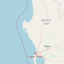
Map view of Cape Winelands Biosphere Reserve

Use this park location map to pinpoint Cape Winelands Biosphere Reserve in South Africa, understand its exact geographic position, and read its mapped placement within the surrounding landscape more clearly.

Pigeon | © OpenStreetMap contributors

Location context for Cape Winelands Biosphere Reserve

Western Cape
Park atlas

Compare regional mountain ranges, valley ecosystems, and adjacent protected areas

Parks Near Cape Winelands Biosphere Reserve and Connected Protected Landscapes

Browsing other protected areas near Cape Winelands Biosphere Reserve reveals broader geographic patterns across the Western Cape mountain chains. Examining adjacent regional landscapes deepens understanding of local Fynbos habitats and mountain catchments.
Watercolor painting of a mountain landscape with green foreground hills and soft purple mountain ranges in the background.
Nature reserveWestern Cape
About 25 km away#1 closest

South

Jonkershoek Nature Reserve: A Detailed Atlas of Mountain Catchment and Fynbos Ecology

Protected mountain geography near Stellenbosch, Western Cape

Jonkershoek Nature Reserve serves as a primary water source for the surrounding Western Cape landscape. This profile outlines the reserve's role in the Cape Floral Region, detailing its complex mountain topography, river headwaters, and significant fynbos plant communities that characterize the terrain.

Area
110 km²
Relief
Mountain
Climate
Mediterranean
Access
Easy access
Nature reserveCape Town
About 40 km away#2 closest

West

Tygerberg Nature Reserve: Geographic Mapping of a Cape Town Protected Landscape

Renosterveld shale ridges and urban conservation context

Tygerberg Nature Reserve stands as a compact, high-value protected area within Cape Town, safeguarding hundreds of plant species and threatened Renosterveld habitats. The park landscape features a recognizable chain of shale hills punctuated by historic termite mounds known as heuweltjies, offering a window into the regional ecology and natural history of the Western Cape.

Area
3 km²
Established
1973
Relief
Upland
Climate
Mediterranean
National parkWestern Cape
About 54 km away#3 closest

Southwest

Table Mountain National Park: Mapped Protected Landscape and Geographic Context in Western Cape

National Park details focused on atlas exploration and regional geography.

Table Mountain National Park is a designated national park within the Western Cape region, offering a distinct geographic profile for atlas exploration. This entity provides detailed mapped boundaries and landscape context, crucial for understanding its role as a protected area in South Africa. Users can explore the specific geography that defines this park and its place within the broader regional context, making it a key point of interest for structured geographic discovery and map-based research.

Area
221 km²
Established
1998
Relief
Mountain
Climate
Mediterranean
Nature reserveWestern Cape
About 54 km away#4 closest

West

Koeberg Nature Reserve: A Geographical Overview of Coastal Protected Landscapes

Lowland fynbos, dune thicket, and aquifer geography in the Western Cape

Situated north of Cape Town, Koeberg Nature Reserve acts as a vital sanctuary for threatened plant communities and diverse bird populations. Its unique terrain combines sandy coastal dunes with seasonal pans and wetland complexes, providing a distinct study in protected area conservation and regional ecological management.

Area
26.81 km²
Established
1991
Relief
Lowland
Climate
Mediterranean
A watercolor illustration of a wide landscape featuring a calm body of water in the foreground, rolling green hills, and purple-toned mountains in the background.
Nature reserveWestern Cape
About 62 km away#5 closest

South

Kogelberg Nature Reserve: Protected Mountain Geography in the Western Cape, South Africa

Coastal mountain fynbos and protected river ecosystems

Situated in the Western Cape of South Africa, Kogelberg Nature Reserve protects an exceptional concentration of fynbos vegetation and rugged sandstone terrain. The area spans coastal mountain ridges, riparian corridors, and forest-filled ravines, serving as a landmark for botanical diversity and protected-landscape mapping in the region.

Area
30 km²
Relief
Mountain
Scope
Terrestrial
Water
Major water bodies
Watercolor painting of a soft, hazy mountain landscape with rolling green hills and pink-toned foreground vegetation, presented in a wide panoramic aspect.
Biosphere reserveWestern Cape
About 74 km away#6 closest

Southwest

Cape Floristic Region: A Detailed Geographic Atlas of the Western Cape Biodiversity Hotspot

Mapped protected biosphere reserve and fynbos landscapes

Explore the Cape Floristic Region, an expansive protected landscape within South Africa. This atlas provides a detailed look at the region's Mediterranean shrublands, sandstone-derived soil terrain, and its status as a singular floral kingdom. Understand the geography of the Western Cape through its mountain ranges and diverse ecological zones.

Area
78,555 km²
Established
2004
A horizontal watercolor painting showing a soft, stylized mountain landscape with green hills, purple shadows, and grassy foreground.
Wildlife reserveWestern Cape
About 80 km away#7 closest

North

Groot Winterhoek Wilderness Area: Protected Mountain Reserve in the Western Cape

Mapping sandstone ridges, fynbos plateaus, and mountain river systems

Spanning 30,000 hectares, Groot Winterhoek Wilderness Area represents a core mountain wilderness in South Africa. Its dissected landscape of Table Mountain sandstone features high peaks, sheltered kloofs, and seasonal rockpools, forming a critical ecological corridor and water catchment within the Cape Fold Belt mountain system.

Area
306.08 km²
Relief
Mountain
Climate
Mediterranean
Access
Moderate access
National parkWestern Cape
About 88 km away#8 closest

Northwest

West Coast National Park: A National Park's Mapped Boundaries and Geographic Identity

Explore its protected landscape within the Western Cape region.

West Coast National Park is a protected national park situated in the Western Cape province of South Africa. This dedicated page provides a structured view of its geographic scope, emphasizing its mapped boundaries and its significance as a protected landscape within the region's broader atlas context. Gain insight into the park's distinct natural terrain and regional geography.

Area
362.59 km²
Established
1985
Climate
Mediterranean
Access
Easy access

Common questions about visiting, size, designation, and location context for Cape Winelands Biosphere Reserve

Cape Winelands Biosphere Reserve FAQs for park facts, access, geography, and protected area context

Find quick answers about Cape Winelands Biosphere Reserve, including protected-area facts, park geography, trail and visitor context, and how the park fits into its surrounding country and regional landscape.
MoriAtlas Explorer

Continue Your Protected Areas Search Across the Global Atlas

Deepen your exploration by continuing the structured search for national parks and protected areas worldwide. Utilize the comprehensive filtering capabilities to compare different conservation landscapes and refine your understanding of global park geography. Discover more about the distribution and characteristics of protected natural areas.

Global natural geography