

Mori Atlas logo
Wildlife reserveCatanduanes Watershed Forest Reserve

A vital hydrological catchment and forest refuge protecting diverse ecosystems across the Bicol Region.

Catanduanes Watershed Forest Reserve: Examining the Geography and Protected Mountain Landscapes of Catanduanes

The Catanduanes Watershed Forest Reserve spans 26,000 hectares of hilly to mountainous terrain, serving as the primary freshwater source for the entire province of Catanduanes. This protected area preserves one of the largest contiguous forest blocks in the region, encompassing dipterocarp stands and steep ridges that rise to Mt. Boctot. Through this atlas entry, analyze the park's catchment boundaries, ecological function, and its role as a critical refuge for endemic species in the Philippines.

watershedforest reservetropical forestdipterocarp forestisland protected areaupland catchment

Catanduanes Watershed Forest Reserve

Wildlife reserve

Park overview

Structured park overview, official facts, and landscape profile for Catanduanes Watershed Forest Reserve

Catanduanes Watershed Forest Reserve park facts, protected area profile, and essential visitor context

Review the core facts for Catanduanes Watershed Forest Reserve, including designation, size, terrain, visitor scale, habitats, and operating context in one park-focused overview.

About Catanduanes Watershed Forest Reserve

Catanduanes Watershed Forest Reserve sits in the Bicol Region of the Philippines, occupying much of the southern and central uplands of Catanduanes Island. Catanduanes is a typhoon-exposed island in the eastern Philippines, separated from the Luzon mainland by a narrow sea channel. The reserve's geography reflects the island's broader character of rugged interior terrain, dense forest cover in upper catchments, and a strong relationship between upland vegetation and downstream water availability.

Beyond its hydrological role, the reserve is significant as one of the most extensive protected forest areas along the eastern Philippine seaboard, where intact forest is increasingly rare and where watersheds support both human populations and ecological communities. Its forested interior helps moderate runoff, sustain stream flow through dry periods, and regulate sediment entering lowland and coastal systems. In conservation terms, this means the reserve functions simultaneously as a natural infrastructure asset and as habitat, with its forest condition directly tied to the wellbeing of people and wildlife across the island.

The reserve was formally established in 1987, placing roughly 26,000 hectares of forested catchment under protection. Management is coordinated through a Protected Area Management Board working under the Department of Environment and Natural Resources, reflecting the standard Philippine framework for protected landscapes of this type. Its role as a working watershed is reinforced by the presence of a small hydroelectric facility, which provides electricity to communities on the island.

For visitors and researchers, the reserve's profile is shaped less by tourist infrastructure and more by its ecological and watershed importance. The protected area offers a rare opportunity to study Bicol forest ecosystems in a setting where conservation outcomes are directly linked to water security for local communities. Within the broader network of Bicol protected areas, alongside sites such as Bulusan Volcano, Mayon Volcano, and Mount Isarog, the Catanduanes Watershed Forest Reserve stands out for its watershed-scale role on an isolated island.

Quick facts and research context for Catanduanes Watershed Forest Reserve

Catanduanes Watershed Forest Reserve is a protected watershed and forest area on Catanduanes Island in the Bicol Region of the Philippines. It was proclaimed under Presidential Proclamation No. 123 in 1987 and is administered by a Protected Area Management Board under the Department of Environment and Natural Resources.

Its area is approximately 26,010 hectares, the dominant land cover is forested upland, and the highest point is Mt. Boctot at 803 meters. It functions as the main water supply catchment for the province and supports a small hydroelectric facility for island communities.

Protection and recognition

Explore documented terrestrial protection parameters and official recognition metrics.

Catanduanes Watershed Forest Reserve Protection Status and Governance Data

Catanduanes Watershed Forest Reserve maintains a recorded terrestrial protection scope within the global protected area registry. Structured metrics outline official designation boundaries and administrative parameters without external conservation claims.

Protection details

Protection scope
Terrestrial
Transboundary protection
No
WDPA ID
71274
Park context

Deeper park guide and search-rich context for Catanduanes Watershed Forest Reserve

Catanduanes Watershed Forest Reserve history, landscape, wildlife, and travel context

Explore Catanduanes Watershed Forest Reserve through its history, landscape character, ecosystems, wildlife, conservation priorities, cultural context, and seasonal travel timing in a structured park guide built for atlas discovery and search intent.

Why Catanduanes Watershed Forest Reserve stands out

The reserve is best known for being the principal watershed supplying freshwater to the province of Catanduanes, while simultaneously preserving one of the largest remaining contiguous forest blocks on the island. Its combination of hydrological function, dipterocarp-dominated forest stands, and habitat for endemic species gives it a distinctly dual identity: a working catchment and a wildlife refuge. Its elevational range, from coastal hill slopes up through Mt. Boctot, creates the conditions for both high rainfall capture and forest-dependent biodiversity. Few protected areas on Catanduanes combine catchment-scale watersheds with such a meaningful concentration of forest habitat.
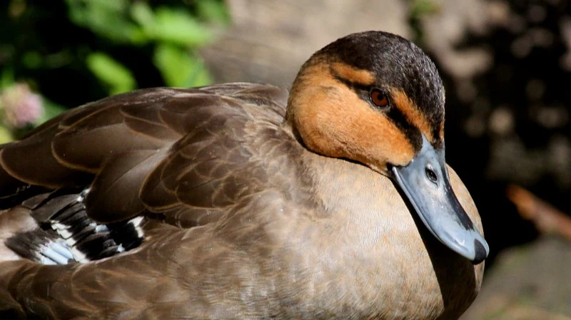
Close-up portrait of a Philippine duck showing its brown feathers, distinct eye stripe, and grey beak.
A Philippine Duck (Anas luzonica) with its characteristic brown plumage and dark eye stripe.

Catanduanes Watershed Forest Reserve history and protected-area timeline

The Catanduanes Watershed Forest Reserve was formally proclaimed in 1987 under Presidential Proclamation No. 123, establishing it as a protected watershed and forest reserve on Catanduanes Island. The proclamation reflected growing recognition of the link between upland forest condition and water supply for the island's communities, particularly in a region exposed to typhoons and heavy seasonal rainfall.

From its inception, the reserve has been integrated into the standard Philippine protected-area framework, administered through a Protected Area Management Board that operates under the Department of Environment and Natural Resources. Its institutional design has emphasized its dual function as a catchment protection area and as a natural area reserve, with hydroelectric generation supporting local energy needs alongside its conservation role.

Over time, the reserve's relevance has only increased as Catanduanes continues to face pressure from typhoons, agricultural expansion, and population growth. Maintaining a substantial intact forest block in the island's central and southern uplands remains central to long-term water security and biodiversity protection in the province.

Catanduanes Watershed Forest Reserve landscape and geographic character

The reserve's terrain is best described as hilly to mountainous, reflecting the volcanic and tectonically active setting of Catanduanes Island. Elevation rises from mid-slope hill country up to Mt. Boctot, the highest point in the reserve at 803 meters above sea level. This combination of steep slopes, narrow valleys, and ridge systems defines the watershed geometry and shapes how rainfall is captured and delivered to downstream communities.

The forested interior dominates the visual and ecological character of the reserve. Although only a portion of the wooded area qualifies as older-growth or near-natural forest, with around 3,200 hectares in that category, the overall extent of tree cover gives the landscape a continuous forested appearance from many vantage points. Streams and small rivers descending from these forested catchments form the headwaters that supply domestic water and feed the local hydroelectric facility.

The broader setting, with Catanduanes itself lying east of mainland Luzon and exposed to Pacific weather systems, adds a climatic edge to the landscape. The reserve's higher elevations regularly receive the orographic uplift of moist tropical air, sustaining the catchment function that defines its purpose and supporting the forest communities that grow on its slopes and ridges.

Catanduanes Watershed Forest Reserve ecosystems, habitats, and plant life

Ecologically, the reserve sits within the lowland and lower montane tropical forest zone characteristic of the eastern Philippines. Where forest stands remain in a near-natural state, they are dominated by trees of the dipterocarp family, a hallmark of Philippine lowland and submontane rainforest composition. These dipterocarp forests are of high conservation interest across the Philippines because of their long history of selective logging and conversion pressure.

Beyond the dominant dipterocarp cover, the reserve includes a mosaic of secondary forest, regenerating areas, and forest patches in different stages of recovery. This gradient from near-natural dipterocarp stands to secondary forest, combined with elevation differences from sea level up to over 800 meters, supports a range of habitat conditions: shaded streamside corridors, ridge-top communities, and slope forest of varying density.

The reserve's hydrology intersects with its ecology in important ways. The streams originating within the reserve are not just a water supply; they also shape riparian microhabitats, support aquatic and semi-aquatic fauna, and maintain humidity conditions that influence amphibian and reptile distribution. This integration of forest, stream, and slope creates the ecological backbone of the reserve and explains why protecting watershed forests has direct consequences for species persistence on the island.

Catanduanes Watershed Forest Reserve wildlife and species highlights

The reserve's forested catchment provides habitat for several forest-dependent mammals of conservation interest. The Philippine warty pig and the Philippine deer are both supported by the reserve's forest cover, and the endemic rodent Phloeomys cumingi, the Southern Luzon giant cloud rat, is recorded within the protected area. Bats documented in the reserve include Rhinolophus rufus and Eonycteris robusta, indicating both cave and forest habitat use by the local bat community.

The reserve is particularly notable for its amphibian and reptile fauna. Frogs recorded in the area include Kaloula conjuncta, Platymantis corrugatus, Platymantis dorsalis, Rana magna, and Rana woodworthi, with Platymantis species being typical Philippine forest-floor frogs of clear conservation concern. Reptiles of note include the skinks Brachymeles samarensis, Dasia grisea, and Lipinia pulchellum, the gliding lizard Draco spilopterus, the dog-faced water snake Cerberus rynchops, and the Philippine forest snake Hologerrhum philippinum, a genus endemic to the Philippines.

Birdlife in and around the reserve includes the Philippine duck, the Philippine cockatoo, the Philippine eagle-owl, and the black-faced kingfisher species group, here referenced under the name Ceyx melanurus. The presence of the Philippine cockatoo and Philippine eagle-owl, both species of conservation concern, is significant in an island setting where remaining mature forest is limited. Together, the mammal, bat, amphibian, reptile, and bird records illustrate that the reserve functions as a refuge for forest species that have been heavily pressured elsewhere on Catanduanes.

Catanduanes Watershed Forest Reserve conservation status and protection priorities

From a conservation standpoint, the Catanduanes Watershed Forest Reserve is significant because it protects one of the largest remaining forested watersheds on a heavily typhoon-exposed island. Watershed reserves of this scale are increasingly rare in the Philippines, and on Catanduanes they play a disproportionate role in sustaining both freshwater supply and forest-dependent biodiversity. The reserve's protected status helps shield its forest cover from the conversion pressures that have affected much of the island's lowland forest.

Its conservation value is closely tied to its hydrological function. Forests regulate stream flow, reduce erosion, and maintain water quality, effects that translate directly into improved resilience for downstream communities during both dry periods and typhoon-driven rainfall events. By maintaining forest cover in the catchment, the reserve indirectly supports coastal and marine systems through reduced sediment runoff, making it a critical component of the island's broader environmental infrastructure.

The reserve is also a stronghold for endemic and range-restricted species, particularly endemic amphibians, reptiles, and mammals. Species such as Hologerrhum philippinum and the cloud rat Phloeomys cumingi depend on the continuity of forest cover that the reserve provides. In this sense, the Catanduanes Watershed Forest Reserve functions as both a working catchment and a biodiversity sanctuary, contributing to the wider conservation of Bicol and Philippine endemic fauna.

Catanduanes Watershed Forest Reserve cultural meaning and human context

Catanduanes has a long-standing identity tied to its forested interior and its exposure to the Pacific, shaping both livelihoods and local awareness of environmental change. The reserve's establishment reflects a provincial recognition that protecting upland forests is essential to securing water for lowland communities, agriculture, and the small hydroelectric facilities that serve the island.

Local communities on Catanduanes have traditionally depended on the products and services of these forests, from water supply to small-scale forest use. The reserve's formal protection through Presidential Proclamation No. 123 represents an institutional affirmation of the connection between forest condition and community wellbeing, reinforcing the forest's role as a shared resource even as it limits extractive uses.

While the source material does not detail specific indigenous cultural traditions, the reserve sits within a regional context where forests, water sources, and rural settlements have long been intertwined. Its management through a Protected Area Management Board further embeds local participation in the governance of a resource of strong provincial significance.

Top sights and standout views in Catanduanes Watershed Forest Reserve

The reserve's standout feature is its dual role as the principal watershed for the province of Catanduanes and as a refuge for forest-dependent wildlife on a heavily weather-exposed island. Its roughly 26,000-hectare forest block protects both freshwater supply and meaningful habitat for endemic mammals, amphibians, reptiles, and birds.

The combination of dipterocarp-dominated stands, steep mountainous terrain culminating in Mt. Boctot, and a network of headwater streams gives the reserve a distinctive catchment ecology. The presence of species such as the Philippine cockatoo, the Southern Luzon giant cloud rat, and the Philippine eagle-owl underlines its significance for Philippine biodiversity conservation beyond its water-supply function.

Best time to visit Catanduanes Watershed Forest Reserve

Like much of the eastern Philippines, Catanduanes is exposed to the Pacific typhoon belt and experiences a pronounced wet season. Periods of relatively calmer weather, generally associated with the drier months between major typhoon activity, tend to offer more stable conditions for any outdoor activity in or near the reserve. Cooler, less humid conditions may also make forest exploration more pleasant, though the reserve is not primarily developed as a tourism site and any visit should reflect the practical realities of accessing upland forest terrain.

Ecology-focused visitors may find that drier periods offer easier observation of wildlife concentrated around remaining water sources, while wetter periods highlight the watershed function the reserve was established to protect. Because typhoons can disrupt both access and conditions, planning around local weather patterns is advisable for anyone considering a visit to the broader Catanduanes area.

Monthly climate preview

Measured long-term temperature ranges and monthly precipitation patterns across the representative coordinate

Catanduanes Watershed Forest Reserve Climate Normals and Weather by Month

Representative point records outline annual temperature variations and monthly precipitation rhythms across the protected landscape. Full climatology data provides a comprehensive monthly breakdown of temperature averages and precipitation totals for further analysis.
Annual mean27 °C
26 °C28 °C
Jan26°
Feb26°
Mar26°
Apr27°
May28°
Jun28°
Jul28°
Aug28°
Sep28°
Oct28°
Nov27°
Dec27°
Warmest month
May

28.2 °C

Coolest month
February

25.9 °C

Wettest month
December

18.6 mm/day

Driest month
April

4.4 mm/day

Park location guide

Geography guide, regional context, and park location map for Catanduanes Watershed Forest Reserve

Catanduanes Watershed Forest Reserve park geography, regions, and map view in Philippines

Understand where Catanduanes Watershed Forest Reserve sits in Philippines through a broader geographic reading of the surrounding landscape, nearby location context, and its mapped position within the national park landscape.

How Catanduanes Watershed Forest Reserve fits into Philippines

The Philippines, officially the Republic of the Philippines, is an archipelagic nation in Southeast Asia comprising approximately 7,641 islands categorized into three main geographical divisions: Luzon, Visayas, and Mindanao. Located in the western Pacific Ocean, it shares maritime borders with Taiwan, Japan, Palau, Indonesia, Malaysia, Vietnam, and China. Manila serves as the capital city, while Quezon City is the most populated city, both within Metro Manila.

Wider geography shaping Catanduanes Watershed Forest Reserve in Philippines

The Philippines is an archipelagic nation in Southeast Asia, positioned in the western Pacific Ocean. Its islands are bounded by the South China Sea to the west, Philippine Sea to the east, and Celebes Sea to the south. The country shares maritime borders with Taiwan to the north, Japan to the northeast, Palau to the east and southeast, Indonesia to the south, Malaysia to the southwest, Vietnam to the west, and China to the northwest.

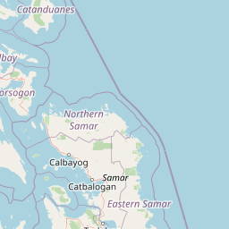
Map view of Catanduanes Watershed Forest Reserve

Use this park location map to pinpoint Catanduanes Watershed Forest Reserve in Philippines, understand its exact geographic position, and read its mapped placement within the surrounding landscape more clearly.

Pigeon | © OpenStreetMap contributors

Location context for Catanduanes Watershed Forest Reserve

Catanduanes

Visual reference for protected upland catchments, dipterocarp forest cover, and island wildlife habitats.

Catanduanes Watershed Forest Reserve Landscape and Scenery Photography

Visual records capture the steep mountainous terrain, dense dipterocarp woodland, and river headwaters defining Catanduanes Watershed Forest Reserve. Photographic documentation reveals the rugged topography and continuous forest canopy supporting regional freshwater supplies and endemic biodiversity.

Close-up portrait of a Philippine duck showing its brown feathers, distinct eye stripe, and grey beak.

Park atlas

Compare regional forested catchments and island wildlife refuges

Parks Near Catanduanes Watershed Forest Reserve And Protected Landscapes

Browse protected areas and upland reserves connected to the regional geography of Catanduanes Watershed Forest Reserve. Extending the geographic review helps map broader conservation landscapes and island habitats across the surrounding region.
National parkCamarines Sur
About 93 km away#1 closest

West

Mount Isarog National Park: Exploring the Volcanic Geography and Forested Slopes of Camarines Sur

Mapping the altitudinal zonation of a significant Luzon stratovolcano

Mount Isarog National Park defines the natural profile of southeastern Luzon. This protected area preserves a full volcanic stratigraphy, ranging from tropical lowland rainforest to stunted mossy summit forests. The park is characterized by its steep ravines, drainage channels, and globally recognized biological endemism, providing a clear example of altitudinal compression within a single mountain ecosystem in the Philippines.

Area
99.71 km²
Established
1938
Relief
Mountain
Climate
Tropical
National parkPhilippines
About 136 km away#2 closest

West

Libmanan Caves National Park: Philippines National Park and Mapped Landscape

Explore protected area boundaries and regional geography.

Libmanan Caves National Park is a protected national park within the Philippines, offering a distinct focus for geographic discovery. This entry provides detailed context on its mapped landscape and its place within the archipelago's protected areas. Users can gain a clear understanding of the park's regional setting, facilitating atlas-style exploration and comprehension of its conservation significance within the Philippine geography.

Area
0.194 km²
Established
1934
IUCN
III
Relief
Upland
Protected areaCamarines Norte
About 161 km away#3 closest

West

Abasig-Matogdon Mananap Natural Biotic Area: Regional Geography and Protected Forest Terrain

A vital ecological reserve in the Bicol Region of Luzon

Located in Camarines Norte, the Abasig-Matogdon Mananap Natural Biotic Area protects critical lowland and montane rainforests surrounding Mount Labo. This area serves as a key component of the regional conservation landscape, defined by its steep volcanic terrain, numerous geothermal springs, and habitat for endemic species within the Philippine archipelago.

Area
54.2 km²
Established
2000
Relief
Mountain
Climate
Tropical
A horizontal watercolor painting of a mangrove forest with green canopies and characteristic prop roots rising from calm, reflective mudflats against a white background.
Protected landscapeCalabarzon
About 169 km away#4 closest

West

Alibijaban Protected Landscape and Seascape: Coastal and Marine Geography

A protected island refuge in the Ragay Gulf of Calabarzon

The Alibijaban Protected Landscape and Seascape is a significant conservation site known for its undisturbed mangrove interior and thriving coral reef ecosystems. Its geography features flat terrain, sandy beaches, and complex seagrass meadows that attract diverse wildlife. This map-based overview provides detailed insights into the protected island's physical boundaries and unique marine-terrestrial intersection.

Area
10.56 km²
Established
1981
Relief
Lowland
Climate
Tropical
Wildlife reserveQuezon
About 188 km away#5 closest

West

Mulanay Watershed Forest Reserve: Mapping Protected Lowland Rainforests in Quezon

A watershed conservation site on the Bondoc Peninsula

Spanning 474 hectares in the province of Quezon, the Mulanay Watershed Forest Reserve acts as a protected anchor for local biodiversity and hydrological health. The reserve preserves rolling, forest-covered hills that feed the Cawayan Creek, illustrating the importance of small, strategically managed protected lands within the larger Philippine conservation framework.

Area
4.74 km²
Established
1938
Relief
Upland
Water
Minor water
Nature reserveQuezon
About 201 km away#6 closest

West

Lopez Watershed Forest Reserve: Protected Nature Reserve and Watershed Atlas of Quezon

A foundational rainforest landscape within the Quezon province protected network.

Lopez Watershed Forest Reserve is a significant nature reserve located in the rolling hills of southern Quezon, Philippines. This site preserves a continuous block of tropical lowland and lower montane forest, functioning as an essential watershed catchment area within the broader Luzon landscape. Learn about its institutional importance and its role as an early component of the Philippine protected area management framework.

Area
4.18 km²
Established
1940
Relief
Upland
Water
Minor water
Wildlife reserveQuezon
About 204 km away#7 closest

West

Calauag Watershed Reservation: Geographic Analysis of Protected Rainforest in Quezon Province

Mapping lowland tropical forest terrain and regional watershed boundaries

Located in the rolling hills of Quezon, the Calauag Watershed Reservation serves as a critical protected landscape featuring dense stands of Philippine hardwoods and varied forest microhabitats. This record details the reserve's topography, ranging from moderate slopes to drainage corridors, illustrating its function as both a biodiversity sanctuary and a essential water catchment for the surrounding CALABARZON region.

Area
3.28 km²
Established
1939
Relief
Upland
Climate
Tropical
National parkSamar
About 213 km away#8 closest

Southeast

Samar Island Natural Park: Geographic Overview and Mapped Protected Boundaries

Eastern Visayas mountain ranges and old-growth forest terrain

Samar Island Natural Park spans the rugged interior of Samar, protecting the largest remaining block of old-growth forest in the Philippines. This expansive protected area integrates diverse terrain ranging from lowland dipterocarp forests to high-elevation mossy cloud forests, while serving as a vital sanctuary for endemic wildlife and a major source of island watersheds.

Area
3,333 km²
Established
2003
IUCN
II
Relief
Mountain

Common questions about visiting, size, designation, and location context for Catanduanes Watershed Forest Reserve

Catanduanes Watershed Forest Reserve FAQs for park facts, access, geography, and protected area context

Find quick answers about Catanduanes Watershed Forest Reserve, including protected-area facts, park geography, trail and visitor context, and how the park fits into its surrounding country and regional landscape.
MoriAtlas Explorer

Continue Your Protected Areas Search Across the Global Atlas

Deepen your exploration by continuing the structured search for national parks and protected areas worldwide. Utilize the comprehensive filtering capabilities to compare different conservation landscapes and refine your understanding of global park geography. Discover more about the distribution and characteristics of protected natural areas.

Global natural geography