
Mori Atlas logo
Nature reserveChristenberger Talgrund

Tracing the valley bog and stream corridor geography within the protected woodlands of central Germany

Christenberger Talgrund Nature Reserve: Mapped Protected Landscapes in the Central Hessian Burgwald

(Naturschutzgebiet Christenberger Talgrund)

Christenberger Talgrund represents a critical nature reserve situated in the Marburg-Biedenkopf district of Hesse, Germany. This protected area centers on a narrow valley floor carved by the Rodenbach, encompassing transitional bog vegetation, peat-forming Sphagnum mosses, and damp deciduous woodland. The reserve serves as a vital ecological link between the forested Burgwald uplands and the western Wetschaft depression, providing a unique look at small-scale wetland conservation in a temperate hill country setting.

nature reservevalley bogtransitional moorpeat bogSphagnumbrown sedge
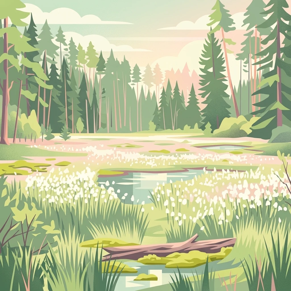
A flat-style digital illustration depicting a wetland or valley moor scene surrounded by a coniferous forest, with a fallen log in the foreground and white flowering vegetation near small pools of water.

Christenberger Talgrund

Nature reserve

Park overview

Structured park overview, official facts, and landscape profile for Christenberger Talgrund

Christenberger Talgrund park facts, protected area profile, and essential visitor context

Review the core facts for Christenberger Talgrund, including designation, size, terrain, visitor scale, habitats, and operating context in one park-focused overview.

About Christenberger Talgrund

Christenberger Talgrund lies in the rolling, forested landscape of central Hesse, at the contact zone between the extensive Burgwald woodlands and the more open Wetschaft depression to the west. The reserve follows a shallow valley drained by the Rodenbach, a small stream that eventually leaves the Burgwald and empties into the Wetschaft river near Simtshausen. Geographically, the site sits south of the Christenberg hill that gives the area its name and stretches northward from the village of Mellnau.

The protected landscape is a mosaic of forest, bog, stream, and meadow. The valley floor carries wet alder and birch woodland as well as valuable peatland communities, while the slopes around it are cloaked in deciduous forest typical of the Burgwald fringe. The transition from damp valley to drier upland creates a strong ecological gradient over a relatively compact area, and the cool, moist local climate has been important in allowing sensitive habitats to persist where they would otherwise have been lost to drainage, forestry intensification, or land-use change.

Although detailed measures are limited in scope, the reserve forms part of the broader Natura 2000 network in the Marburg-Biedenkopf district, alongside other FFH sites in the Burgwald and surrounding lowlands. Its relatively undisturbed peatland vegetation and the surviving populations of rare plants, dragonflies, and bog-adapted invertebrates give it a conservation importance well beyond its size on the map.

Quick facts and research context for Christenberger Talgrund

Christenberger Talgrund is a statutory nature reserve (Naturschutzgebiet) and FFH site located in the Marburg-Biedenkopf district of Hesse, on the territory of the town of Wetter (Hessen). It occupies roughly 105 to 117 hectares of valley floor and adjacent slopes on the western fringe of the Burgwald, north of Mellnau and southeast of Münchhausen am Christenberg.

The area was formally protected in 1987 under the designation 1534018 and became a Natura 2000 (FFH) site in 2008 with the code DE5018304. It is classified under IUCN Category IV as a Habitat/Species Management Area and is administratively linked to the Rodenbach stream, a tributary of the Wetschaft river.

Protection and recognition

Documented Natura 2000 listings and protected area records for Christenberger Talgrund

Christenberger Talgrund Protection Status and International Recognition Data

Examine documented protection records and official Natura 2000 designations established for Christenberger Talgrund. Review verified international recognition sources detailing the conservation framework governing this protected landscape.
Park context

Deeper park guide and search-rich context for Christenberger Talgrund

Christenberger Talgrund history, landscape, wildlife, and travel context

Explore Christenberger Talgrund through its history, landscape character, ecosystems, wildlife, conservation priorities, cultural context, and seasonal travel timing in a structured park guide built for atlas discovery and search intent.

Why Christenberger Talgrund stands out

Christenberger Talgrund is best known for its surviving valley moor and bog vegetation, which is unusual in this part of Hesse and echoes the character of similar protected peatland complexes nearby such as the Wiesbüttmoor and the Rotes Wasser von Olfen. The reserve also stands out for its assemblage of specialized plant and invertebrate species tied to cool, waterlogged conditions. Notable records include the peat moss Sphagnum imbricatum, the sundew Drosera intermedia, several dragonfly species such as the two-striped springfly (Cordulegaster boltonii) and the blue-winged demoiselle, and the bordered huntsman spider. Together these give the site a high conservation value despite its modest size.
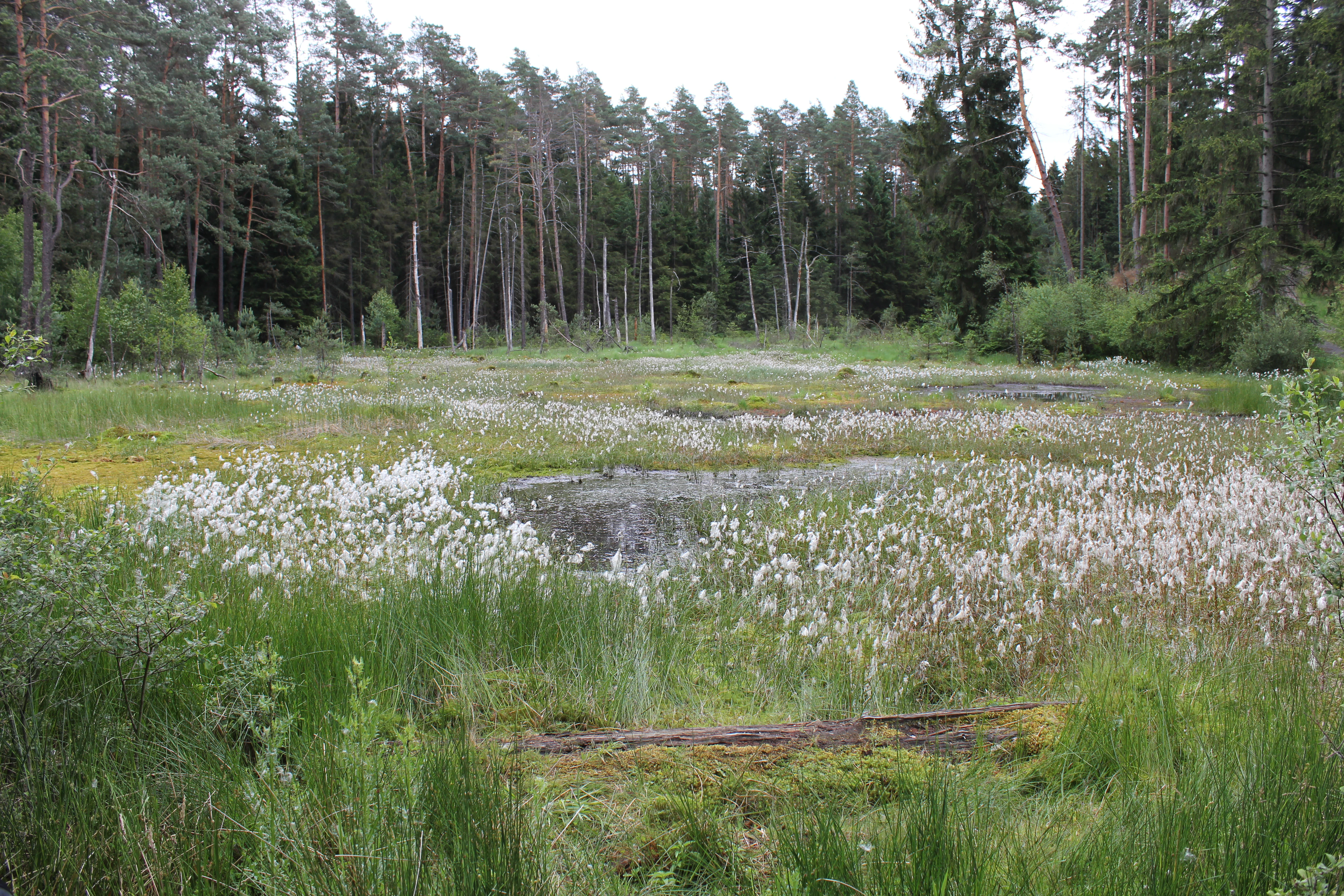
A meadow filled with white flowering cottongrass surrounding small patches of standing water, with a dense coniferous forest in the background.
Flowering cottongrass within the moor habitat of Christenberger Talgrund.

Christenberger Talgrund history and protected-area timeline

The Christenberger Talgrund area was placed under formal nature protection in 1987, when the Land of Hesse designated it as a Naturschutzgebiet under the identifier 1534018. This designation reflected recognition that the valley's bog vegetation and damp forest communities were exceptional for the region and vulnerable to ongoing drainage pressure.

Earlier in the twentieth century, the valley moor had been affected by multiple attempts at drainage, typical of how wet valley floors across Hesse were reclaimed for forestry or agriculture. Despite these interventions, the core of the peatland remained near-natural, which became one of the reasons the area was selected for protection.

In 2008, the valley was further recognized through its inclusion in the European Natura 2000 network as an FFH area, with the site code DE5018304. The FFH designation essentially mirrors the national nature reserve boundary, reinforcing the area's role in the conservation of bog forest and peatland habitats at the European level.

Christenberger Talgrund landscape and geographic character

Geographically, Christenberger Talgrund occupies a small valley basin within the larger Burgwald uplands of central Hesse. Elevations within the reserve range from roughly 290 meters to about 390 meters above sea level, placing it firmly in the lower hill country rather than in high mountains. The terrain is shaped by the gentle incision of the Rodenbach, which has carved a shallow valley between forested hills.

The valley floor is the visually distinctive part of the reserve: a flat, waterlogged corridor where peat has accumulated and where the Rodenbach meanders slowly through boggy ground. Around this central wetland, slopes rise into mixed deciduous woodland typical of the Burgwald, blending beech and other broadleaf species with damp-loving alder and birch along the stream margins. The western end of the reserve opens toward the cleared Wetschaft depression, marking a sharp transition from closed forest to more open farmland.

The result is a compact but varied landscape where stream valley, bog, and hillside forest meet, and where the contrast between the cool, sheltered valley interior and the more exposed edges gives the area much of its character.

Christenberger Talgrund ecosystems, habitats, and plant life

Ecologically, Christenberger Talgrund is defined by its rare combination of transitional bog vegetation and damp deciduous forest. The cool, humid microclimate of the valley floor supports communities of brown sedge (Carex nigra group) and an unusually rich cover of peat mosses, including the species Sphagnum imbricatum, which is otherwise scarce in the region. These peat-forming communities sit within a broader matrix of wet and mesic woodland.

The surrounding slopes and fringes of the valley carry threatened broadleaf forest communities whose composition is shaped by the same moisture and shade conditions that protect the bog vegetation below. This layering of bog and forest within a single valley is the key ecological signature of the site.

In its ecological character, the reserve closely resembles other protected wetland complexes in the area, such as the Wiesbüttmoor and the Rotes Wasser von Olfen, and is best understood as part of a small chain of peatland and wet forest refuges along the western edge of the Burgwald.

Christenberger Talgrund wildlife and species highlights

The wildlife of Christenberger Talgrund is closely tied to the wet valley environment, and the conservation profile of the reserve emphasizes invertebrates and plant species rather than large mammals or birds. The boggy conditions have allowed a specialized community of dragonflies and other wetland insects to persist, with documented species including the two-striped springfly (Cordulegaster boltonii), a spring-dwelling dragonfly, as well as the vividly colored blue-winged demoiselle.

The reserve also hosts the bordered huntsman spider, an arachnid characteristic of damp, mossy habitats. Such bog-adapted invertebrate species are not only notable in themselves but also serve as indicators of the quality and continuity of the conservation habitat.

The surrounding deciduous forest layer provides habitat for generalist woodland species typical of the Burgwald area more broadly, although specific records are not detailed in the available sources. The overall wildlife significance of the reserve is best read through its invertebrate and botanical specialists rather than through charismatic megafauna.

Christenberger Talgrund conservation status and protection priorities

Christenberger Talgrund is recognized as ecologically significant at multiple administrative levels. Nationally, it has been a designated nature reserve (Naturschutzgebiet) since 1987 in order to protect its bog vegetation and damp forest communities from drainage and forestry pressures. At the European level, an almost identical area was designated as an FFH site in 2008 under the EU Habitats Directive.

The reserve's core conservation value lies in the survival of a near-natural valley moor despite repeated historical attempts to drain it. Within Hesse, only a small number of sites still harbor comparable transitional bog vegetation with Sphagnum species such as Sphagnum imbricatum, placing Christenberger Talgrund among the more important remaining peatland refuges in the region.

By combining national protection with Natura 2000 status, the area benefits from a long-term legal framework that restricts damaging land use and reinforces its role in the broader protected-area network of the Marburg-Biedenkopf district.

Christenberger Talgrund cultural meaning and human context

The Christenberger Talgrund takes its name from the nearby Christenberg, a historically prominent hill in central Hesse that has long served as a local landmark and reference point. The valley itself sits between two historic settlement areas of the region: the town of Wetter (Hessen) to the northwest and the smaller communities of Mellnau and Münchhausen am Christenberg to the east and southeast.

The broader Burgwald area carries a long history of forest use, including timber harvesting, charcoal burning, and grazing, which has shaped the wooded landscape around the reserve. The valley's wet conditions once made it a difficult but valued source of meadow hay and peat resources, while the surrounding forests supported traditional woodland crafts that defined local livelihoods for centuries.

Today the area's cultural significance lies less in active human use and more in its role as a surviving fragment of a traditional Hessian rural and forest landscape, where small villages, wooded ridges, and sheltered stream valleys together form a regional identity that the nature reserve helps to preserve.

Top sights and standout views in Christenberger Talgrund

Among the most distinctive features of Christenberger Talgrund is the surviving transitional bog vegetation on the valley floor, with peat-forming mosses including the regionally rare Sphagnum imbricatum and broad stands of brown sedge. This habitat, persisting despite twentieth-century drainage attempts, gives the reserve much of its conservation weight.

Equally notable is the reserve's assemblage of moisture-dependent invertebrate species, from the two-striped springfly and blue-winged demoiselle dragonflies to the bordered huntsman spider, together signaling a healthy bog ecosystem in a relatively small area. The compact layering of bog, stream, and wet forest within a single valley, framed by the broader Burgwald woodlands, makes the site unusually rich for its modest size.

Best time to visit Christenberger Talgrund

A visit to Christenberger Talgrund is most rewarding in late spring and early summer, when rising temperatures encourage active dragonfly flight along the Rodenbach and sundews and other bog plants are visibly flowering in the damp valley. Spring itself can also be atmospheric, as the cool valley microclimate and damp forest vegetation are best appreciated before the full leaf canopy closes overhead.

Late summer and early autumn bring warmer, drier conditions that still allow bog and forest walking, and the Sphagnum-rich peatland vegetation remains green while beech and other broadleaves on the slopes begin to turn. Winter visits are less common but offer a quieter view of the valley structure and stream channels, though boggy ground and shorter daylight reduce accessibility for casual exploration.

Monthly climate preview

Long-term temperature and monthly precipitation patterns sampled across representative coordinate elevations

Christenberger Talgrund Climate Normals and Average Temperature Profiles

Historical climate records outline the measured annual temperature progression and monthly precipitation rates for Christenberger Talgrund based on long-term data. Detailed monthly breakdowns provide deeper comparative context regarding average temperature swings and precipitation distribution across the protected area.
Annual mean8 °C
-1 °C18 °C
Jan-1°
Feb
Mar
Apr
May12°
Jun15°
Jul18°
Aug17°
Sep13°
Oct
Nov
Dec
Warmest month
July

17.6 °C

Coolest month
January

-1 °C

Wettest month
July

2.6 mm/day

Driest month
April

1.7 mm/day

Park location guide

Geography guide, regional context, and park location map for Christenberger Talgrund

Christenberger Talgrund park geography, regions, and map view in Germany

Understand where Christenberger Talgrund sits in Germany through a broader geographic reading of the surrounding landscape, nearby location context, and its mapped position within the national park landscape.

How Christenberger Talgrund fits into Germany

Germany is a federal republic in Western and Central Europe with a population of over 83 million across sixteen constituent states. It is Europe's largest economy by nominal GDP and a major global exporter and importer. The capital is Berlin, and the country borders Denmark, Poland, Czech Republic, Austria, Switzerland, France, Luxembourg, Belgium, and the Netherlands.

Wider geography shaping Christenberger Talgrund in Germany

Germany is located in Western and Central Europe, spanning 357,022 km². It borders Denmark to the north, Poland and the Czech Republic to the east, Austria and Switzerland to the south, and France, Luxembourg, Belgium, and the Netherlands to the west. The country has coastlines on the Baltic Sea and North Sea to the north, with the Alps located in the southern region.

Map view of Christenberger Talgrund

Use this park location map to pinpoint Christenberger Talgrund in Germany, understand its exact geographic position, and read its mapped placement within the surrounding landscape more clearly.

Pigeon | © OpenStreetMap contributors

Location context for Christenberger Talgrund

Hesse

Visual reference guide to the valley moor, stream corridors, and woodland habitats of central Hesse

Christenberger Talgrund Photos and Protected Landscape Scenery

Visual records capture the distinctive valley floor, meandering stream corridors, and transitional bog vegetation defining the protected reserve. Detailed habitat photography illustrates the cool microclimate and rare peat moss ecosystems characterizing the local terrain.

A meadow filled with white flowering cottongrass surrounding small patches of standing water, with a dense coniferous forest in the background.

Park atlas

Compare regional valley reserves and connected woodland habitats across central Hesse

Other Parks Near Christenberger Talgrund and Surrounding Protected Areas

Browsing other parks near Christenberger Talgrund reveals shared wetland valleys and protected forest remnants across the Burgwald fringe. Comparing these adjacent protected landscapes provides broader geographic context for central German conservation terrains.
Watercolor illustration depicting a serene wetland landscape with a small forest patch on the left, grassy marshland in the center, and a pink-toned shoreline on the right.
Nature reserveHessen
About 3.4 km away#1 closest

East

Franzosenwiesen/Rotes Wasser: Protected Nature Reserve and Lowland Stream Geography

Hessen regional conservation and Burgwald foothills terrain

The Franzosenwiesen/Rotes Wasser reserve offers a window into the lowland stream geography of central Germany. This site preserves a vital corridor of wet meadows and riparian habitat along the Rotes Wasser brook, serving as a key example of the conservation landscapes found within the rolling foothills of the Burgwald region in Hessen.

Area
0.898 km²
Established
1987
Relief
Lowland
Climate
Temperate
A watercolor painting depicting a soft-focus landscape with rolling green hills in the distance, a grassy foreground, and a single bare-branched tree on the right side.
Nature reserveHessen
About 7.6 km away#2 closest

East

Merzhäuser Teiche Nature Reserve: Geographic Atlas and Protected Landscape Overview

A dense wetland mosaic in the Burgwald region of Hessen.

Merzhäuser Teiche is a compact nature reserve situated on the edge of the Burgwald, Hesse's largest contiguous forest. Centered on three small ponds linked by the Kimmelbach, the area protects a transition zone of alder swamp, wet meadows, and nutrient-poor grassland. This site serves as a crucial habitat for waterbirds, amphibians, and rare butterflies within a characteristic central German landscape.

Area
0.201 km²
Established
1990
IUCN
IV
Relief
Lowland
Watercolor painting of a tranquil wetland scene with grassy banks, small pools of water, and rolling hills in the background.
Nature reserveHessen
16 km away#3 closest

South

Kleine Lummersbach bei Cyriaxweimar Protected Nature Reserve and Hessian Landscape Geography

A diverse forest and grassland habitat within the Marburg-Biedenkopf district

Kleine Lummersbach bei Cyriaxweimar offers an exceptional case study in protected area geography. Formed by a blend of mature oak and beech forests, nutrient-poor meadows, and seasonal ponds, the reserve provides a critical refuge for protected amphibians and bats. Its varied terrain, spanning from dense woodland to open, grazed clearings, makes it a vital site for biodiversity conservation in central Germany.

Area
1.383 km²
Established
1997
IUCN
IV
Relief
Upland
A soft watercolor painting showing layered, gentle green hills and rolling terrain against a light, pale sky.
Nature reserveHessen
18 km away#4 closest

East

Kalkkuppen bei Winterscheid: Protected Geological Landscapes in the Gilserberg Heights

A detailed atlas view of this Hessen nature reserve

This nature reserve in the Schwalm-Eder-Kreis district protects four distinctive limestone hills built from Lower Muschelkalk. These outcrops stand as a geological anomaly within a region otherwise dominated by sandstone. The site serves as a vital component of the European Habitats Directive, offering a rare opportunity to study calcareous vegetation patterns and structural geology within the rolling terrain of northern Hesse.

Area
0.429 km²
Established
1986
IUCN
IV
Watercolor painting showing a landscape with hills, forest, and a body of water
National parkHesse
20 km away#5 closest

Northeast

Kellerwald-Edersee National Park: Hesse's Protected Landscape Exploration

Mapped boundaries and geographic context for this German national park.

Navigate the protected landscape of Kellerwald-Edersee National Park, a key national park situated in the German state of Hesse. This atlas entry focuses on its precise geographic definition, mapped terrain features, and the broader regional context it occupies within central Germany. Gain structured insights into the park's conservation significance and its place in the mapped landscape.

Area
76.88 km²
Established
2004
IUCN
II
Relief
Highland
A watercolor painting showing a soft, green, rolling valley with a stream and yellow wildflowers in the foreground against a light, distant hilly horizon.
Nature reserveNorth Rhine-Westphalia
About 22 km away#6 closest

North

Naturschutzgebiet Ölfetal: Mapped Boundaries and Grassland Ecosystems in the Sauerland

A regional protected nature reserve near Medebach

Naturschutzgebiet Ölfetal offers a detailed look into the meadow-and-stream ecology of the Sauerland uplands. Stretching along the Ölfe river, the reserve features a complex mosaic of wet and dry meadow habitats that support specific plant species and local grassland bird populations. Its protected status maintains a vital stream corridor that bridges agricultural zones and broader ecological networks within eastern North Rhine-Westphalia.

Area
0.124 km²
Established
2003
Relief
Lowland
Scope
Terrestrial
Watercolor painting of green rolling hills and a calm, pale water surface under a soft, light-colored sky.
Protected landscapeHessen
About 23 km away#7 closest

Northeast

Naturpark Kellerwald-Edersee: Protected Landscape Geography and Map Context

Mapping the forest ridges and reservoir shores of northern Hessen

Examine the geographic foundation of Naturpark Kellerwald-Edersee, a sprawling protected area in northern Hessen. The landscape is characterized by its expansive ancient beech forests, deep valleys, and the Edersee reservoir. This entry provides a detailed look at the park's low mountain terrain, elevation ranges, and the ecological connectivity between its wooded ridges and surrounding river systems.

Area
595.25 km²
Established
2001
Relief
Mountain
Climate
Temperate
A horizontal watercolor painting depicting a soft-focus landscape of low green hills, wooded areas, and open fields under a pale sky.
Protected landscapeHessen
About 24 km away#8 closest

Southwest

Naturpark Lahn-Dill-Bergland: Protected Area Mapping and Geographic Landscape Overview

Regional Mittelgebirge terrain in the heart of Hessen

Naturpark Lahn-Dill-Bergland serves as a core protected landscape in western Hessen, spanning the districts of Marburg-Biedenkopf and Lahn-Dill-Kreis. This atlas entry details the park's topography, including the Bottenhorner Hochflächen and the expansive forest masses of the Schelder Wald, providing a clear geographic context for its layered ridges and scenic river valley systems.

Area
830.9 km²
Established
2007
Relief
Mountain
Climate
Temperate

Common questions about visiting, size, designation, and location context for Christenberger Talgrund

Christenberger Talgrund FAQs for park facts, access, geography, and protected area context

Find quick answers about Christenberger Talgrund, including protected-area facts, park geography, trail and visitor context, and how the park fits into its surrounding country and regional landscape.
MoriAtlas Explorer

Continue Your Protected Areas Search Across the Global Atlas

Deepen your exploration by continuing the structured search for national parks and protected areas worldwide. Utilize the comprehensive filtering capabilities to compare different conservation landscapes and refine your understanding of global park geography. Discover more about the distribution and characteristics of protected natural areas.

Global natural geography