
Mori Atlas logo
Nature reserveCodfish Island / Whenua Hou

Mapping the terrain and conservation landscape of this remote New Zealand sanctuary

Codfish Island / Whenua Hou: An Essential Nature Reserve and Protected Island Geography

Codfish Island / Whenua Hou serves as a critical nature reserve situated in the Tasman Sea, west of Stewart Island in the Southland Region. This 14 square kilometre landmass represents a rugged and predator-free sanctuary defined by coastal forest, rocky shores, and central high ground reaching 250 metres. The geography provides an undisturbed mosaic of habitats for seabirds and endemic species within a remote maritime climate.

predator-free islandkākāpō sanctuaryseabird breeding siteImportant Bird AreaNew Zealand offshore islandsubantarctic wildlife
A flat, stylized digital illustration of a coastal scene with a sandy beach in the foreground, lush green hills, a small waterfall cascading into the sea, and mountain silhouettes under a warm, pastel-colored sky.

Codfish Island / Whenua Hou

Nature reserve

Park overview

Structured park overview, official facts, and landscape profile for Codfish Island / Whenua Hou

Codfish Island / Whenua Hou park facts, protected area profile, and essential visitor context

Review the core facts for Codfish Island / Whenua Hou, including designation, size, terrain, visitor scale, habitats, and operating context in one park-focused overview.

About Codfish Island / Whenua Hou

Codfish Island / Whenua Hou lies in the cool southern waters of the Tasman Sea, northwest of Stewart Island / Rakiura and far to the south of the New Zealand mainland. Although it covers only about 14 square kilometres, the island packs an unusual concentration of ecological and cultural significance. Its terrain rises from coastal bays to a high point of roughly 250 metres near the south coast, creating a landscape of ridges, forest cover, sheltered inlets, and exposed shoreline. Because access is restricted, the island remains largely unmodified by recent human activity and functions today as a working scientific reserve rather than a public destination.

From an ecological perspective, Whenua Hou is one of the most important islands in the New Zealand archipelago for native wildlife conservation. Its forest and coastline support a wide range of endemic and rare bird species, including forest birds such as kākā, fernbirds, red-fronted and yellow-crowned parakeets, and Pacific black ducks, as well as colonies of seabirds breeding along its coast. The southern short-tailed bat also inhabits the island, adding a distinctive mammalian element to its wildlife community.

The island is equally significant in cultural and historical terms. Its name "Whenua Hou," meaning "new land" in Māori, is linked to one of the earliest recorded mixed Māori and European settlements in the region, established under the protection of the Ngāi Tahu rangatira Honekai in the early nineteenth century. Archaeological investigations have revealed evidence of pre-European Māori settlement as well as the historical sealing-period community at Sealers Bay, giving the island a layered human story that complements its modern identity as a sanctuary for species that exist nowhere else on Earth.

Quick facts and research context for Codfish Island / Whenua Hou

Codfish Island / Whenua Hou is a 14-square-kilometre uninhabited island northwest of Stewart Island / Rakiura in New Zealand's Southland Region. It rises to roughly 250 metres in elevation along its southern shore and sits within the broader New Zealand archipelago in the Tasman Sea. The island is administered by the New Zealand Department of Conservation and is closed to casual visitors, functioning primarily as a scientific and conservation reserve.

BirdLife International has recognized the island as an Important Bird Area for its seabird breeding colonies, and the Department of Conservation has used it as the main kākāpō recovery stronghold. The land carries a dual Māori and English name, reflecting ongoing recognition of its place in Ngāi Tahu history and its long role in early mixed Māori and European settlement.

Protection and recognition

Examine documented terrestrial conservation metrics and management history.

Codfish Island / Whenua Hou Protection Status and Mapped Boundaries

Codfish Island / Whenua Hou maintains a dedicated terrestrial protection scope without transboundary overlap or imported international listings. Review verified administrative records and designation details associated with this protected landscape.

Protection details

Protection scope
Terrestrial
Transboundary protection
No
Park context

Deeper park guide and search-rich context for Codfish Island / Whenua Hou

Codfish Island / Whenua Hou history, landscape, wildlife, and travel context

Explore Codfish Island / Whenua Hou through its history, landscape character, ecosystems, wildlife, conservation priorities, cultural context, and seasonal travel timing in a structured park guide built for atlas discovery and search intent.

Why Codfish Island / Whenua Hou stands out

Codfish Island / Whenua Hou is best known as the principal sanctuary for the kākāpō, the critically endangered, flightless night parrot endemic to New Zealand. After the successful eradication of introduced predators such as rats and possums in 1998, the island became the most important refuge in efforts to save the species from extinction. At any given time, the majority of the world's remaining kākāpō live there, and several of the species' best-known breeding seasons have taken place on Whenua Hou. The island is also recognized for its broader role as a seabird sanctuary. It is an Important Bird Area for Fiordland penguins, yellow-eyed penguins, mottled petrels, Cook's petrels, and the Whenua Hou diving petrel, and it has served as a translocation site for rare species such as the Snares Island snipe. Whenua Hou is widely seen as one of the most biologically significant predator-free islands in the New Zealand subantarctic region.
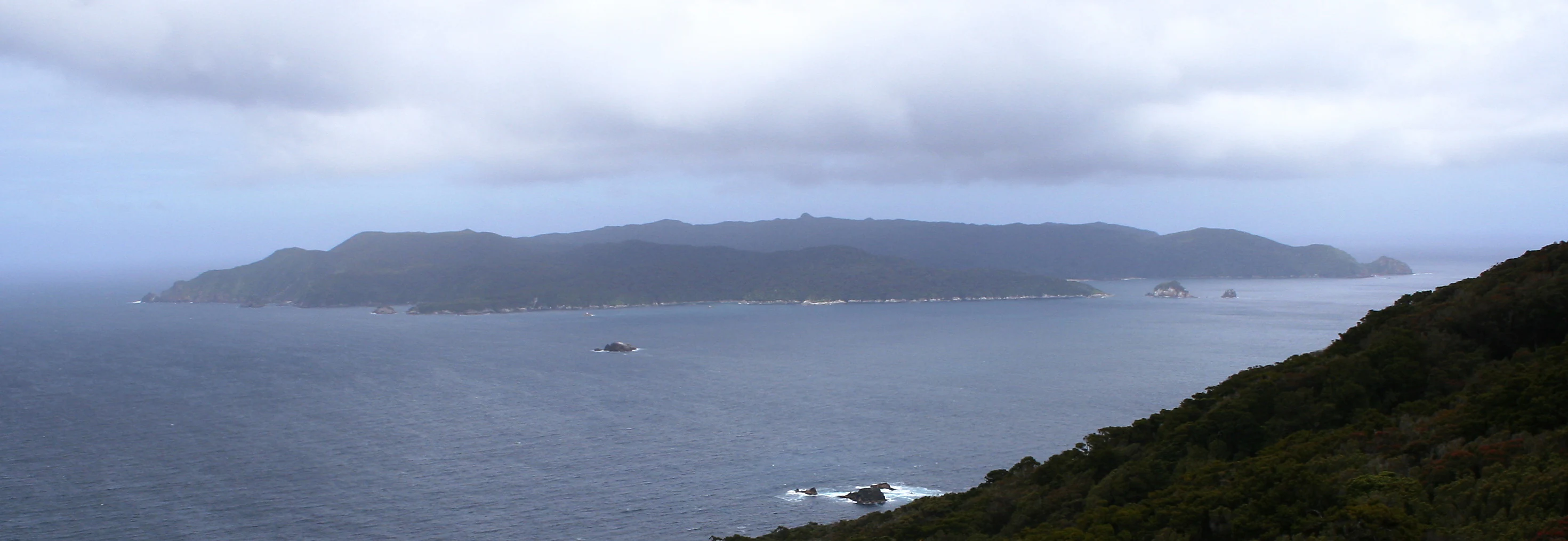
A wide, overcast view looking across a body of water toward the forested landmass of Codfish Island.
A view of Codfish Island / Whenua Hou, a protected island reserve off the coast of New Zealand.

Codfish Island / Whenua Hou history and protected-area timeline

The history of Codfish Island / Whenua Hou begins well before European contact. Archaeological investigations in 2007, led by Angela Middleton, Ian Smith, and Atholl Anderson, identified two distinct phases of human occupation. The earliest phase dates from approximately the 13th to 15th centuries, when Māori communities were active throughout New Zealand, leaving behind stone artefacts and middens containing fish, bird, and mammal bones. The second phase occurred during the 19th century, broadly from 1800 to 1830, in the era of European sealing and exploration.

In 1808 the island received the English name "Pegasus Island" from the whaler Eber Bunker, prompted by the landing of sealers and the beginnings of European habitation. Because of tensions caused by sealers on nearby Stewart Island and concerns over the treatment of local Māori women, the Ngāi Tahu rangatira Honekai designated Whenua Hou as the site of a protected mixed-race settlement. Under his authority, Europeans who had married or partnered with Māori women, including figures such as Thomas Chaseland, were encouraged to relocate to the island. This settlement at Sealers Bay became one of the first sustained mixed Māori and European communities in southern New Zealand, and the names "Codfish Island" and "Whenua Hou" were both in use by around 1824.

The modern conservation era began in 1987, when the first kākāpō were transferred to the island from Stewart Island. Following the eradication of possums and rats in 1998 and the later removal of weka, the island became a predator-free refuge and the central hub for kākāpō recovery. Since then, major breeding seasons in 2002, 2009, and 2016 have helped drive population growth for the species, and the Department of Conservation now uses Codfish Island / Whenua Hou as a principal site for ongoing native species management. The island remains closed to the general public, with access reserved for researchers, Department of Conservation staff, and authorized conservation volunteers working under permit.

Codfish Island / Whenua Hou landscape and geographic character

Codfish Island / Whenua Hou is a compact island covering about 14 square kilometres, set in the open waters of the Tasman Sea west of Stewart Island. Its topography is shaped by its southern exposure and maritime climate, with a low-to-moderate relief that rises to a maximum elevation of around 250 metres near the south coast. From this central high ground, slopes descend into coastal forest, rocky shoreline, and sheltered bays such as Sealers Bay on the northeast of the island.

The island's vegetation is dominated by temperate coastal forest, which extends down to the shore in many places and creates a habitat mosaic that supports both forest-inhabiting birds and seabirds nesting along the coast. The remote position, steep terrain, and lack of permanent human settlement have preserved a relatively undisturbed natural landscape.

Codfish Island / Whenua Hou ecosystems, habitats, and plant life

Ecologically, Codfish Island / Whenua Hou functions as a near-pristine predator-free refuge in the southern New Zealand archipelago. Because rats, possums, and weka have been removed, the island supports a community of birds, bats, and seabirds that would otherwise be highly vulnerable to introduced mammals. Forest habitats fill much of the interior, while coastal cliffs and rocky shorelines provide nesting opportunities for a wide range of seabird species.

The island sits within a broader regional ecosystem that includes Stewart Island / Rakiura and surrounding waters, and its biological character shares much with that larger landmass. However, the absence of predators and the focus on active species management have made its ecological communities unusually intact compared with much of the New Zealand mainland.

Codfish Island / Whenua Hou wildlife and species highlights

Codfish Island / Whenua Hou supports a remarkable concentration of New Zealand's most threatened native species. Among its most recognizable residents are kākā, fernbirds, red-fronted and yellow-crowned parakeets (kākāriki), Pacific black ducks, and a recently introduced population of mōhua. The island is also home to the southern short-tailed bat, one of New Zealand's few native terrestrial mammals and a species of significant conservation interest.

The island's seabird colonies are internationally recognized. BirdLife International has designated Whenua Hou as an Important Bird Area because of its importance as a breeding site for Fiordland penguins, yellow-eyed penguins, mottled petrels, Cook's petrels, and the Whenua Hou diving petrel. Conservation managers have also translocated Snares Island snipes to the island, expanding the range of this rare shorebird.

The most famous wildlife story associated with Whenua Hou, however, is that of the kākāpō. Roughly half of the global population of this critically endangered, flightless parrot resides on the island, and it has become the leading site for kākāpō recovery. The island's most famous individual is Sirocco, a male kākāpō born on Codfish Island in 1997, who was later named New Zealand government's Official Spokesbird for Conservation.

Codfish Island / Whenua Hou conservation status and protection priorities

Codfish Island / Whenua Hou is regarded as one of the most important offshore conservation sites in New Zealand. Its status as a predator-free island, achieved through the eradication of rats, possums, and weka, makes it a critical refuge for species that have been heavily impacted by introduced mammals on the mainland. The island's importance is recognized internationally through its designation as an Important Bird Area by BirdLife International.

The island anchors the national recovery programme for the kākāpō, hosting the majority of the species' breeding population and acting as the operational centre for intensive monitoring and management. Major breeding events on the island in 2002, 2009, and 2016 produced some of the largest chick cohorts in kākāpō recovery history. The Department of Conservation also uses the island for related species management, including the introduction of Snares Island snipes and mōhua.

In addition to its ecological work, conservation management on Codfish Island / Whenua Hou incorporates the protection of its cultural and archaeological heritage. Earlier surveys identified sites of pre-European Māori settlement and items from the 19th-century mixed Māori and European community at Sealers Bay, ensuring that the island's historical significance is considered alongside its wildlife values.

Codfish Island / Whenua Hou cultural meaning and human context

Codfish Island / Whenua Hou holds deep significance in both Māori and early European colonial history of southern New Zealand. The Māori name "Whenua Hou," meaning "new land," reflects the island's role as a place where a new community was deliberately established. In the early 19th century, the Ngāi Tahu rangatira Honekai designated the island as a refuge for sealers who had taken Māori wives, in response to tensions over their presence on Stewart Island. This made Sealers Bay one of the earliest documented mixed Māori and European settlements in the region.

Archaeological work in 2007 revealed evidence of much older human activity, including stone artefacts and middens from Māori occupation during the 13th to 15th centuries. These findings indicate that Whenua Hou was part of broader Māori use of the southern islands long before European arrival. The dual Māori and English place name that is now official reflects the island's ongoing importance in the cultural landscape of Ngāi Tahu and in the wider history of southern New Zealand.

Top sights and standout views in Codfish Island / Whenua Hou

Codfish Island / Whenua Hou's standout qualities include its role as the centre of New Zealand's kākāpō recovery programme and its status as a predator-free island of national and international importance. The presence of homes for more than 70 kākāpō, including the famous Sirocco, gives the island a unique place in global wildlife conservation.

Equally notable are its recognized seabird colonies, which have earned the island Important Bird Area status, and its layered cultural history, spanning early Māori settlement and one of the first mixed Māori and European communities in southern New Zealand.

Best time to visit Codfish Island / Whenua Hou

Codfish Island / Whenua Hou is closed to casual visitors and unauthorized landings, and there is no general public tourism season. Access is permitted only to authorized Department of Conservation staff, scientific researchers, and conservation volunteers, with arrivals typically by light aircraft or helicopter into Sealers Bay. For those involved in conservation or research visits, the most productive periods of activity tend to align with the summer months in the Southern Hemisphere, when seabird breeding, kākāpō monitoring, and significant fieldwork are concentrated.
Monthly climate preview

Long-term representative point measurements tracking annual temperature and precipitation rhythm

Codfish Island / Whenua Hou Climate Normals and Monthly Temperature Patterns

Measured representative coordinate records show mean temperatures ranging from roughly nine to thirteen degrees Celsius alongside steady year-round precipitation. Detailed monthly climate profiles provide complete twelve-month temperature and precipitation breakdowns for deeper geographical study.
Annual mean11 °C
9 °C13 °C
Jan13°
Feb13°
Mar13°
Apr12°
May11°
Jun
Jul
Aug
Sep10°
Oct10°
Nov11°
Dec12°
Warmest month
February

13.5 °C

Coolest month
July

9 °C

Wettest month
January

4.9 mm/day

Driest month
August

3.6 mm/day

Park location guide

Geography guide, regional context, and park location map for Codfish Island / Whenua Hou

Codfish Island / Whenua Hou park geography, regions, and map view in New Zealand

Understand where Codfish Island / Whenua Hou sits in New Zealand through a broader geographic reading of the surrounding landscape, nearby location context, and its mapped position within the national park landscape.

How Codfish Island / Whenua Hou fits into New Zealand

New Zealand is an island nation in the southwestern Pacific Ocean comprising two main islands and numerous smaller islands. Located east of Australia across the Tasman Sea, it features varied topography with the Southern Alps running along the South Island and volcanic terrain on the North Island. The country was settled by Maori people between 1280 and 1350, followed by European exploration beginning in 1642, and became a Dominion in 1907 before gaining full independence in 1947.

Wider geography shaping Codfish Island / Whenua Hou in New Zealand

New Zealand lies in the southwestern Pacific Ocean, east of Australia across the Tasman Sea. The country consists of two main islands, the North Island and South Island, plus over 600 smaller islands. The North Island features volcanic plateaus and hills while the South Island is dominated by the Southern Alps mountain range. The country has a long coastline and is surrounded by the Pacific Ocean.

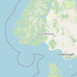
Map view of Codfish Island / Whenua Hou

Use this park location map to pinpoint Codfish Island / Whenua Hou in New Zealand, understand its exact geographic position, and read its mapped placement within the surrounding landscape more clearly.

Pigeon | © OpenStreetMap contributors

Location context for Codfish Island / Whenua Hou

Southland Region

Visual exploration of coastal forest habitats and protected island terrain.

Codfish Island / Whenua Hou Photos and Landscape Scenery

Visual documentation captures the rugged terrain, temperate coastal forest, and isolated shorelines defining Codfish Island / Whenua Hou. Photographic archives reveal the protected natural environment and remote island habitats supporting endangered wildlife sanctuaries.

A wide, overcast view looking across a body of water toward the forested landmass of Codfish Island.

A close-up of a young kākāpō with mottled green and brown feathers standing on dark soil and leaf litter, with a human boot visible in the background.

Park atlas

Compare nearby protected areas and regional conservation zones in southern New Zealand

Other Parks Near Codfish Island / Whenua Hou and Protected Landscapes

Browse protected areas near Codfish Island / Whenua Hou to examine related island ecosystems and coastal sanctuaries across the region. Regional park comparison provides deeper context into subantarctic wildlife habitats and predator-free conservation networks.
National parkNew Zealand
About 5.3 km away#1 closest

East

Rakiura National Park: New Zealand's Remote Protected Wilderness & Landscape Atlas

Explore its rugged terrain and unique subantarctic ecosystem.

Rakiura National Park encompasses the majority of Stewart Island, offering a unique glimpse into one of New Zealand's most remote and undisturbed natural environments. This protected landscape features rugged forested hills, extensive coastlines with isolated beaches, and is globally recognized for its abundant kiwi populations. Discover the park's geographic setting and its significance as a protected area for both wildlife and cultural heritage within the broader atlas of New Zealand's natural wonders.

Area
1,399.6 km²
Established
2002
IUCN
II
Relief
Lowland
Wildlife reserveNew Zealand
About 42 km away#2 closest

Southeast

Ulva Island Wildlife Reserve: Mapped Geography and Protected Forest Landscapes

An open sanctuary located in Paterson Inlet, New Zealand

Explore the unique geography of Ulva Island, a 2.7 square kilometre wildlife reserve within Rakiura National Park. This predator free island features dense temperate rainforest, sheltered coastal bays, and vital recovery habitats for native bird species, offering a distinct study in southern New Zealand's protected forest terrain.

Area
2.67 km²
Relief
Lowland
Climate
Temperate
Access
Easy access
National parkSouthland Region
About 63 km away#3 closest

North

Fiordland National Park: A Protected Landscape of Glacier-Carved Fiords and Alpine Wilderness

Explore its vast boundaries and unique temperate rainforest.

Fiordland National Park, located in the Southland Region of New Zealand, is a testament to dramatic geological forces, featuring fifteen major fiords like Milford Sound, whose Mitre Peak rises majestically from the water. This protected national park encompasses an immense wilderness of alpine terrain, ancient beech forests, and numerous waterfalls, fueled by exceptional rainfall. Its inclusion in the Te Wāhipounamu World Heritage Area underscores its global significance for biodiversity and natural landscape preservation.

Area
12,607 km²
Established
1952
IUCN
II
Visitors
500K annual
Marine protected areaFiordland
About 139 km away#4 closest

Northwest

Moana Uta (Wet Jacket Arm) Marine Reserve: Mapped Protected Landscapes in Fiordland

Exploring unique fiord stratification and dense marine coral habitats

Located in the remote southwestern reaches of New Zealand, Moana Uta (Wet Jacket Arm) Marine Reserve preserves a complete fiord system. The area is notable for its exceptional physical conditions, including high black coral density and a distinct freshwater surface layer that sustains diverse underwater communities across steep rock walls, reefs, and deep basins.

Area
20.07 km²
Established
2005
Relief
Lowland
Climate
Temperate
Marine protected areaFiordland
About 154 km away#5 closest

North

Taipari Roa (Elizabeth Island) Marine Reserve: Fiordland Marine Landscape and Atlas Map

Protected marine terrain and glacial fjord geography

Taipari Roa (Elizabeth Island) Marine Reserve is a protected marine area situated within the complex fjord network of Doubtful Sound. The reserve is characterized by steep underwater rock walls, deep kelp forests, and a unique freshwater cap that allows rare corals and glass sponges to thrive at shallow depths. This geographic overview examines the reserve's protected status and its structural role within the broader Fiordland ecosystem, highlighting the vertical aquatic terrain and surrounding islet environments.

Area
6.13 km²
Established
2005
Relief
Lowland
Climate
Temperate
Watercolor painting of a green, hilly landscape with a winding river or inlet and pale, misty mountains in the background.
Marine protected areaFiordland
About 166 km away#6 closest

North

Kutu Parera (Gaer Arm) Marine Reserve: Fiordland Protected Marine Landscape Atlas

Mapped marine boundaries, stratified fiord ecology, and coastal terrain analysis

Explore the structured geography of Kutu Parera (Gaer Arm) Marine Reserve, a 433-hectare protected area located within the steep, mountain-flanked fjords of New Zealand. Gain insight into its complex underwater features, including vertical rock walls, estuarine basins, and stratified water columns that define this unique marine environment within the Fiordland region.

Area
4.33 km²
Established
2005
Relief
Mixed relief
Climate
Temperate
Marine protected areaFiordland
About 185 km away#7 closest

North

Kahukura (Gold Arm) Marine Reserve: Marine Protected Area and Fiordland Geographic Atlas

Submerged rocky reefs and vertical rock wall landscapes

Located in the heart of New Zealand, Kahukura (Gold Arm) Marine Reserve provides a vital map of protected coastal terrain. Its unique environment features freshwater caps, tannin-stained deep water, and diverse marine topography ranging from sheltered basin ecosystems to vertical cliff structures. This marine area offers deep insight into the complex geology and conservation dynamics of the Fiordland region.

Area
4.64 km²
Established
2005
Relief
Mixed relief
Climate
Temperate
Marine protected areaFiordland
About 217 km away#8 closest

North

Hawea (Clio Rocks) Marine Reserve: Protected Marine Geography in Fiordland, New Zealand

Mapping vertical rock walls and stratified fiord water ecosystems.

Hawea (Clio Rocks) Marine Reserve is an ecologically significant marine protected area situated within the deep waters of Hāwea / Bligh Sound. The reserve is defined by its dramatic vertical rock walls, tidal current channels, and the complex water stratification that sustains diverse black coral and reef communities. It offers a unique window into the geological and marine processes that have shaped the rugged coastal landscape of New Zealand's Fiordland.

Area
4.11 km²
Established
2005
IUCN
Ia
Relief
Mountain

Common questions about visiting, size, designation, and location context for Codfish Island / Whenua Hou

Codfish Island / Whenua Hou FAQs for park facts, access, geography, and protected area context

Find quick answers about Codfish Island / Whenua Hou, including protected-area facts, park geography, trail and visitor context, and how the park fits into its surrounding country and regional landscape.
MoriAtlas Explorer

Continue Your Protected Areas Search Across the Global Atlas

Deepen your exploration by continuing the structured search for national parks and protected areas worldwide. Utilize the comprehensive filtering capabilities to compare different conservation landscapes and refine your understanding of global park geography. Discover more about the distribution and characteristics of protected natural areas.

Global natural geography