

Mori Atlas logo
Nature reserveColeford Nature Reserve

Mapping the grassland and wetland ecosystems of the Ngwagwane River valley region

Coleford Nature Reserve: A Protected Landscape in the KwaZulu-Natal Drakensberg Foothills

Coleford Nature Reserve occupies 1,272 hectares within the rolling foothills of the Drakensberg escarpment. This provincial protected area showcases a complex terrain of sandstone cliffs, hilly moist grasslands, and expansive wetland habitats. Positioned within the Greater Ingwangwana River Important Bird Area, the reserve serves as a vital sanctuary for endangered species and represents a transitional geography between the high mountain range and the interior of South Africa.

Drakensberg foothillsmoist grasslandwetland reserveImportant Bird Areawattled cranewhite-winged flufftail

Coleford Nature Reserve

Nature reserve

Park overview

Structured park overview, official facts, and landscape profile for Coleford Nature Reserve

Coleford Nature Reserve park facts, protected area profile, and essential visitor context

Review the core facts for Coleford Nature Reserve, including designation, size, terrain, visitor scale, habitats, and operating context in one park-focused overview.

About Coleford Nature Reserve

Coleford Nature Reserve occupies a strategic position in the foothills of the central Drakensberg, in the southwestern portion of KwaZulu-Natal. Lying about 18 kilometres south of Underberg, the reserve sits within the Sub-Escarpment Grassland Bioregion and forms part of the protected landscape that buffers the uKhahlamba Drakensberg Park World Heritage Site. Its 1,272 hectares span hilly terrain, sandstone cliffs in the northwest, and the valley of the Ngwagwane River, which flows southeast through the southern portion of the reserve and is joined by the Ndawana River near the reserve's southeastern corner.

The reserve's ecological importance is closely tied to the grassland and wetland mosaic it preserves. Drakensberg Foothill Moist Grassland is a threatened vegetation type associated with highly weathered soils derived from dolerite and sandstone, supporting a range of restricted-range plant species. The associated wetland communities, including sedge marshes and floodplain habitats, have been damaged historically by drainage works but have been progressively restored since the mid-1980s. This wetland system underpins much of Coleford's identity, both ecologically and in terms of bird conservation.

Coleford is particularly valued for its contribution to South Africa's threatened crane and flufftail populations. The reserve was historically an important nesting area for wattled cranes until disturbance in the early 1990s led to local abandonment, and successful breeding returned to the reserve in the 2010s after habitat restoration and the removal of grazing livestock. Passive monitoring between 2020 and 2025 has also confirmed the presence of the critically endangered white-winged flufftail, a secretive wetland-dependent bird whose South African breeding evidence was first documented only in 2018. Beyond these headline species, the reserve supports a broad community of grassland, wetland, and cliff-nesting birds, alongside populations of several antelope species and vulnerable small carnivores.

As a provincial nature reserve managed by Ezemvelo KZN Wildlife, Coleford also offers limited recreation, including fly fishing on the Ngwagwane River and stocked dams, hiking, and birdwatching from a small bird hide on the wetland margins. A former hutted rest camp within the reserve has been closed to the public, leaving the site primarily oriented towards conservation, research, and low-impact day use.

Quick facts and research context for Coleford Nature Reserve

Coleford Nature Reserve is a 1,272 hectare provincial protected area in KwaZulu-Natal, South Africa, situated in the Drakensberg foothills south of Underberg. It is classified as IUCN Category IV (habitat and species management area), was established in 1948, and was formally proclaimed in 1959. The reserve is governed by Ezemvelo KZN Wildlife and lies within the Greater Ingwangwana River Important Bird Area.

The protected vegetation type is Drakensberg Foothill Moist Grassland, a threatened ecosystem found at elevations between roughly 880 and 1,860 metres. The reserve is a recognised priority wetland site in KwaZulu-Natal and holds confirmed or breeding habitat for the endangered wattled crane and the critically endangered white-winged flufftail.

Protection and recognition

Documented terrestrial protection scope, establishment year, and international recognition facts

Coleford Nature Reserve Protection Status and Designation History

Terrestrial protection status for Coleford Nature Reserve spans documentation from its establishment year in 1959. Structured facts present verified designation history and management scope without imported international recognition sources.

Protection details

Protection scope
Terrestrial
Designated year
1959
Transboundary protection
No
Park context

Deeper park guide and search-rich context for Coleford Nature Reserve

Coleford Nature Reserve history, landscape, wildlife, and travel context

Explore Coleford Nature Reserve through its history, landscape character, ecosystems, wildlife, conservation priorities, cultural context, and seasonal travel timing in a structured park guide built for atlas discovery and search intent.

Why Coleford Nature Reserve stands out

Coleford is most strongly associated with two pieces of conservation significance: its role as a key site for the endangered wattled crane, whose nesting history at the reserve was interrupted by disturbance and later restored through habitat rehabilitation, and its importance for the critically endangered white-winged flufftail, for which it is one of only a small number of South African localities with recent confirmed sightings. The reserve is also recognised for its protected representation of Drakensberg Foothill Moist Grassland, a vegetation type that has been heavily reduced outside formal reserves. The combination of hilly grassland, wetland mosaic, sandstone cliffs, and the Ngwagwane River gives Coleford a distinctive ecological character within the broader Drakensberg conservation landscape.

Coleford Nature Reserve history and protected-area timeline

The area around modern-day Coleford had a turbulent reputation during the colonial period. It was historically described as a no-man's land, serving as a refuge for bandits, cattle rustlers, and gun runners whose presence made the area unattractive to early European settlers. The region was reputedly not permanently inhabited by Indigenous communities at the time of European arrival, a background that partly explains why it remained in a relatively unmodified natural state for so long.

The land is associated with James Cole, the original European settler in the area, who gave his name to Coleford despite, according to tradition, neither farming nor living at the property. The reserve itself was established in 1948 and formally proclaimed in 1959. After an extended period of neglect, the site has been brought under more active management by Ezemvelo KZN Wildlife and is now treated as an important component of KwaZulu-Natal's protected-area system in the southwestern Drakensberg foothills.

Coleford Nature Reserve landscape and geographic character

Coleford lies within the foothills of the Drakensberg escarpment, where the terrain transitions from the high mountain grasslands of the main range to the rolling interior of KwaZulu-Natal. The reserve's topography is dominated by hilly grassland and wetland, with cliffs of Beaufort Group sandstone rising in the northwestern portion of the property and giving way to the open valley of the Ngwagwane River in the south.

The Ngwagwane River is the principal hydrological feature of the reserve. It flows southeastward through the southern portion of Coleford and is joined by the Ndawana River, its major tributary, in the southeastern corner of the area. The river, its tributary, and several stocked dams shape the wetland mosaic that gives the reserve much of its ecological character. The vegetation of the reserve, including Drakensberg Foothill Moist Grassland and associated wetland plant communities, occupies elevations roughly between 880 and 1,860 metres above sea level, placing Coleford in the lower reaches of the Drakensberg foothills.

Coleford Nature Reserve ecosystems, habitats, and plant life

The reserve's vegetation is classified as Drakensberg Foothill Moist Grassland, a threatened ecosystem linked to highly weathered upland soils derived from dolerite and sandstone. This vegetation type supports a range of plant species with restricted distributions, and has been extensively reduced outside formal reserves through agricultural conversion and commercial forestry plantations across its historical range. Within Coleford, the grassland is interlaced with sedge marshes and floodplain wetland communities that are critical for the reserve's birdlife and for amphibian populations.

Wetland vegetation was historically impacted by drainage ditches, but rehabilitation work beginning in 1984 has restored significant portions of these habitats. Research on the surrounding Sub-Escarpment Grassland Bioregion has shown that this environment depends on a complex balance of climate, soils, and herbivory, and is vulnerable to shifts in nutrient supply and grazing pressure, factors that influence how the vegetation of Coleford is likely to respond to ongoing environmental change.

Coleford Nature Reserve wildlife and species highlights

Coleford supports a diverse community of large herbivores, including black wildebeest, blesbok, red hartebeest, southern reedbuck, grey rhebok, common duiker, and oribi. The oribi is listed as a vulnerable species nationally, making its continued presence a noteworthy feature of the reserve's mammal fauna. The reserve is also home to two Red Data mammal species, the serval and the African striped weasel, both classified as rare.

Birdlife is the most distinctive component of the reserve's fauna. Coleford is a known site for the endangered wattled crane and the critically endangered white-winged flufftail, two wetland-dependent species with very restricted global populations. Other notable birds recorded in or around the reserve include Cape vulture, bush blackcap, African marsh harrier, black harrier, blue crane, grey crowned crane, Denham's bustard, southern ground hornbill, striped flufftail, half-collared kingfisher, buff-streaked chat, sentinel rock thrush, black-winged lapwing, and black stork, the last of which breeds in nearby mountains and forages within the reserve. The Ngwagwane River and its dams also support both introduced rainbow trout and indigenous freshwater species including Natal yellowfish, chubbyhead barb, and African longfin eel.

Coleford Nature Reserve conservation status and protection priorities

Coleford plays a recognised role in the conservation of both threatened grassland and threatened wetland birds in KwaZulu-Natal. Its formal status as a provincial nature reserve managed under IUCN Category IV reflects a management approach focused on safeguarding particular habitats and species rather than setting aside wilderness in the strictest sense. The reserve is part of the Greater Ingwangwana River Important Bird Area, and the Ngwagwane River catchment has been identified as significant for biodiversity conservation at a regional scale.

Wetland restoration is one of the reserve's most important conservation efforts. Drainage works had degraded key sedge and floodplain habitats before rehabilitation began in 1984, and ongoing management has been credited with the return of wattled cranes as breeding birds in the early 2010s. The reserve's wetlands are also rated among the priority wetlands of KwaZulu-Natal and have been the focus of targeted surveys for white-winged flufftail using passive monitoring and camera traps since 2020. Ongoing conservation concerns include invasive alien plants, poaching pressure on sensitive species such as nesting wattled cranes, and the broader risks of nutrient enrichment and changes in herbivore abundance to Drakensberg Foothill Moist Grassland, which research has shown can reduce species richness even when overall productivity increases.

Coleford Nature Reserve cultural meaning and human context

Coleford's cultural background is unusual among KwaZulu-Natal protected areas. During the colonial period, the area was widely described as a no-man's land, functioning as a refuge for bandits, cattle rustlers, and gun runners and remaining largely unsettled, even at the time of European contact. This frontier reputation contributed both to the late and limited settlement of the area and to the relative preservation of its natural vegetation.

The reserve's name derives from James Cole, the original European settler in the area. Cole owned the land but, by tradition, never farmed there or lived at Coleford, a detail that has become a small but persistent element of the local identity of the site. Today the reserve is valued less for historical buildings or cultural sites than for the relatively undisturbed natural landscape that resulted from this unusual settlement history.

Top sights and standout views in Coleford Nature Reserve

Among Coleford's most distinctive features is its combination of threatened Drakensberg Foothill Moist Grassland with restored sedge and floodplain wetland habitats, a pairing that supports some of South Africa's rarest wetland-dependent birds. The reserve is one of only a handful of South African sites with recent confirmed records of the critically endangered white-winged flufftail, and is a known nesting location for the endangered wattled crane following wetland rehabilitation.

The reserve also offers meaningful mammal viewing, productive fly fishing on the Ngwagwane River and its dams, and easy access from Underberg into the broader uKhahlamba Drakensberg Park World Heritage Site via the Ngoangoana Gate.

The reserve's position at the lower edge of the Drakensberg foothills gives it a transitional character between montane Drakensberg grasslands and the rolling interior of KwaZulu-Natal, a quality expressed in its mix of sandstone cliffs, hilly grassland, river valley, and wetland mosaic.

Best time to visit Coleford Nature Reserve

Coleford lies in a temperate highland climate with summer rainfall, mild temperatures, and relatively low frost incidence compared to higher-altitude Drakensberg grasslands. Mean annual temperatures in the broader bioregion are around 15.5 degrees Celsius, with annual precipitation of roughly 763 millimetres falling predominantly in the warmer months.

For visitors interested in grassland and wetland birdlife, the warmer, wetter months typically offer richer conditions for observation and the most active period for many breeding species. Cooler, drier months may offer clearer weather for hiking and broader scenic enjoyment of the foothills, though some wetland-dependent species may be less conspicuous outside the warmer season.
Monthly climate preview

Long-term representative monthly temperature and precipitation rhythm in KwaZulu-Natal

Coleford Nature Reserve Climate Normals and Annual Temperature Patterns

Historical climate data for Coleford Nature Reserve reveals a defined annual temperature range alongside distinct monthly precipitation variations across the representative coordinate. Examining the complete twelve-month record provides deeper insight into measured long-term averages for temperature and rainfall.
Annual mean14 °C
7 °C18 °C
Jan18°
Feb18°
Mar16°
Apr13°
May10°
Jun
Jul
Aug10°
Sep14°
Oct15°
Nov17°
Dec18°
Warmest month
January

18.3 °C

Coolest month
July

7.3 °C

Wettest month
January

6.5 mm/day

Driest month
June

0.5 mm/day

Park location guide

Geography guide, regional context, and park location map for Coleford Nature Reserve

Coleford Nature Reserve park geography, regions, and map view in South Africa

Understand where Coleford Nature Reserve sits in South Africa through a broader geographic reading of the surrounding landscape, nearby location context, and its mapped position within the national park landscape.

How Coleford Nature Reserve fits into South Africa

South Africa is the southernmost country in Africa, spanning 1.22 million km² with a population of over 63 million. The country operates with three capital cities, Pretoria (executive), Cape Town (legislative), and Bloemfontein (judicial), and is renowned for its biodiversity, national parks, and multicultural society.

Wider geography shaping Coleford Nature Reserve in South Africa

South Africa occupies the southernmost region of Africa, with coastline along both the Atlantic Ocean to the west and the Indian Ocean to the east. The interior features elevated plateaus including the Highveld, with the Drakensberg escarpment marking the eastern highlands. The country shares borders with Namibia, Botswana, Zimbabwe, Mozambique, Eswatini, and Lesotho.

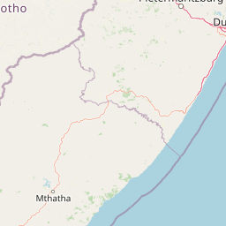
Map view of Coleford Nature Reserve

Use this park location map to pinpoint Coleford Nature Reserve in South Africa, understand its exact geographic position, and read its mapped placement within the surrounding landscape more clearly.

Pigeon | © OpenStreetMap contributors

Location context for Coleford Nature Reserve

KwaZulu-Natal
Park atlas

Compare regional wetland reserves and grassland habitats across south-western KwaZulu-Natal.

Other Parks Near Coleford Nature Reserve and Protected Areas in the Drakensberg Foothills

Browse protected areas near Coleford Nature Reserve to examine similar moist grassland ecosystems and river valleys in the surrounding region. Comparing adjacent mountain reserves provides a wider perspective on the ecological corridors and conservation networks spanning the KwaZulu-Natal interior.
Nature reserveKwaZulu-Natal
About 16 km away#1 closest

South

Ntsikeni Nature Reserve: High-Elevation Wetland Geography and Protected Landscape Atlas

A remote Drakensberg foothills wetland and montane grassland reserve.

Ntsikeni Nature Reserve is recognized as the largest and one of the highest wetlands in South Africa. Located in the KwaZulu-Natal province, this protected area features a unique, misty plateau landscape that sustains diverse orchid flora and essential headwater ecosystems. Use these geographic maps to examine the terrain, park boundaries, and the ecological transition between rolling foothills and the Drakensberg escarpment.

Area
92.87 km²
Established
1978
Relief
Upland
Climate
Temperate
A watercolor illustration featuring soft, green rolling hills in the foreground with pale, layered mountain peaks in the background, set against a plain white field.
Protected areaKwaZulu-Natal
About 17 km away#2 closest

Northwest

Maloti-Drakensberg Park Geography: Mountain Escarpments and Alpine Plateau Exploration

A transboundary protected landscape spanning South Africa and Lesotho

Spanning the core of the Drakensberg mountain system, Maloti-Drakensberg Park provides a unique window into high-altitude biodiversity and geological drama. The protected area features basalt cliffs, rolling valleys, and an extensive plateau, forming a critical ecological and cultural corridor. This atlas entry covers the topographic features and spatial distribution of one of southern Africa's most significant protected landscapes.

Area
2,493.13 km²
Established
2001
Relief
Mountain
Climate
Alpine
Protected areaKwaZulu-Natal
About 17 km away#3 closest

North

uKhahlamba-Drakensberg Park: Protected Mountain Landscapes and Escarpment Geography in South Africa

Exploring the basalt cliffs and alpine plateau of KwaZulu-Natal.

uKhahlamba-Drakensberg Park encompasses an expansive protected region where the Drakensberg escarpment rises sharply from the foothills of KwaZulu-Natal. This atlas record details the park landscape, including its transition from sandstone terraces to high-altitude basalt, its extensive river gorges, and the concentration of archaeological cave sites. Use this resource to understand the geographic scale of this transboundary conservation area.

Area
2,429.13 km²
Relief
Mountain
Climate
Temperate
Access
Access unknown
National parkQacha's Nek District
About 25 km away#4 closest

West

Sehlabathebe National Park: Mapped Protected Landscape in Lesotho's Maloti Mountains

Explore high-altitude terrain, waterfalls, and ancient rock art sites.

Sehlabathebe National Park stands as a protected national park within the rugged Maloti Mountains of Lesotho's Qacha's Nek District. This destination is vital for understanding the geographic context of protected areas, featuring dramatic cliffs, iconic waterfalls like Tsoelikana, and numerous rock art sites that speak to its cultural and historical significance. Its high-altitude Afro-Alpine and sub-alpine ecosystems offer unique landscape characteristics and support notable biodiversity, making it a key point of interest for atlas-driven exploration of natural and protected terrains.

Area
69.5 km²
Established
1969
IUCN
IV
Relief
Mountain
Nature reserveKwaZulu-Natal
About 57 km away#5 closest

Northeast

Impendle Nature Reserve: Protecting Endangered Grasslands and Mistbelt Ecosystems

A highland conservation sanctuary in the KwaZulu-Natal region

Located in the mist-prone foothills of the Drakensberg, Impendle Nature Reserve stands as a critical block of surviving Midlands Mistbelt Grassland. The reserve terrain combines rugged dolerite ridges with moisture-rich seepage zones and wetlands, providing a specialized habitat for threatened bird species. This protected area remains a significant site for regional biodiversity, emphasizing scientific conservation over expansive development within the KwaZulu-Natal landscape.

Area
30.46 km²
Established
1983
IUCN
IV
Relief
Upland
Nature reserveKwaZulu-Natal
About 61 km away#6 closest

South

Mount Currie Nature Reserve: A Detailed Geographic Atlas of KwaZulu-Natal Mountains

High-altitude wetlands and protected Drakensberg foothills

Mount Currie Nature Reserve encompasses a rugged expanse of Drakensberg foothills characterized by sharp dolerite cliffs and expansive central wetland systems. This protected area acts as a crucial ecological intersection, bridging montane grassland and Afromontane forest patches while providing a sanctuary for diverse avian life and significant cultural heritage sites.

Area
17.77 km²
Established
1980
IUCN
IV
Relief
Mountain
National parkEastern Cape
About 114 km away#7 closest

Southwest

Grassland National Park National Park: Exploring Protected Landscapes and Regional Geography

Mapped boundaries and natural terrain context for an Eastern Cape protected area.

Grassland National Park represents a crucial protected area within South Africa's Eastern Cape province. As a national park, it offers significant insights into the region's natural landscapes and geographic character. This atlas perspective focuses on understanding the park's mapped scope, its terrain features, and its place within the broader provincial geography. Discover the unique protected landscape identity of Grassland National Park and how it contributes to the mapped natural heritage of the Eastern Cape.

Area
102.25 km²
Established
2025
IUCN
II
Relief
Mountain
Protected areaQuthing District
About 129 km away#8 closest

West

Lake Letsie Protected Area and Highland Wetland Geography in Quthing District

Mapping a unique Afroalpine reservoir and its surrounding catchment

Situated in the Quthing District of Lesotho, Lake Letsie is an essential protected landscape characterized by its shallow freshwater basin and high-altitude wetland habitat. This site provides critical insights into Afromontane biodiversity, regional water management, and the ecological impact of transboundary environmental factors on highland terrain.

Area
4.34 km²
Established
2001
Relief
Mountain
Climate
Alpine

Common questions about visiting, size, designation, and location context for Coleford Nature Reserve

Coleford Nature Reserve FAQs for park facts, access, geography, and protected area context

Find quick answers about Coleford Nature Reserve, including protected-area facts, park geography, trail and visitor context, and how the park fits into its surrounding country and regional landscape.
MoriAtlas Explorer

Continue Your Protected Areas Search Across the Global Atlas

Deepen your exploration by continuing the structured search for national parks and protected areas worldwide. Utilize the comprehensive filtering capabilities to compare different conservation landscapes and refine your understanding of global park geography. Discover more about the distribution and characteristics of protected natural areas.

Global natural geography

