Mori Atlas logo
Marine protected areaCordell Bank National Marine Sanctuary

A submerged geological relic of the Sierra Nevada rising from the California continental shelf

Cordell Bank National Marine Sanctuary: Mapping the Granite Seamount and Marine Protected Area

Cordell Bank National Marine Sanctuary protects a unique granite seamount that rises abruptly from the seafloor off the California coast. This underwater mountain range fragment creates a vital convergence zone where cool, nutrient-rich currents fuel a high concentration of marine life. Discover the mapped boundaries and geographic context of this offshore marine sanctuary, serving as a critical feeding ground for migratory whales, diverse seabirds, and extensive rockfish populations.

marine sanctuaryseamountsubmerged granitecontinental shelfupwelling ecosystemCalifornia Current

Cordell Bank National Marine Sanctuary

Marine protected area

Park overview

Structured park overview, official facts, and landscape profile for Cordell Bank National Marine Sanctuary

Cordell Bank National Marine Sanctuary park facts, protected area profile, and essential visitor context

Review the core facts for Cordell Bank National Marine Sanctuary, including designation, size, terrain, visitor scale, habitats, and operating context in one park-focused overview.

About Cordell Bank National Marine Sanctuary

Cordell Bank National Marine Sanctuary protects one of the more unusual ocean environments on the United States West Coast. The central feature of the sanctuary is Cordell Bank itself, a granite seamount that sits on the continental shelf roughly fifty miles northwest of San Francisco. The bank's upper pinnacles come within about 115 feet of the surface, while the surrounding seafloor drops by more than a mile within just a few miles of the bank. This sharp transition from soft, sediment-covered shelf to hard, elevated rock creates a habitat mosaic that is rare along the Pacific coast and is at the heart of the sanctuary's ecological significance.

The sanctuary's identity is shaped as much by oceanographic forces as by geology. The southward-flowing California Current drives seasonal upwelling along the coast, pulling cold, nutrient-rich water toward the surface around the bank. In calmer months, the northward-flowing Davidson Current replaces these waters with warmer, less nutrient-rich flows, and winter storms further mix the water column. The result is a dynamic and predictable seasonal rhythm of productivity that the entire sanctuary's biology is tuned to, from phytoplankton at the base of the food web up through whales and seabirds at the top.

Cordell Bank is part of the U.S. National Marine Sanctuary System, one of thirteen such sanctuaries managed nationally to preserve representative and ecologically important marine environments. The sanctuary's regulations specifically prohibit hydrocarbon extraction, the removal of bottom-dwelling organisms, the discharge of waste, and the disturbance of cultural resources, reflecting the high conservation value placed on the site. Recreational diving is generally discouraged because of depth and current conditions, leaving the bank essentially undisturbed and observed primarily through scientific research and surface-level wildlife viewing.

The sanctuary supports an extraordinary concentration of marine mammals, seabirds, and fish that has earned it both national and international recognition. Endangered blue and humpback whales aggregate here to feed, large flocks of seabirds including several albatross species forage above the bank, and more than 240 fish species find shelter among the rocky pinnacles. This richness, set against the backdrop of an otherwise open and relatively unproductive stretch of ocean, is what makes Cordell Bank one of the defining marine protected areas of the California coast.

Quick facts and research context for Cordell Bank National Marine Sanctuary

Cordell Bank National Marine Sanctuary lies off the northern California coast, approximately fifty miles northwest of San Francisco. It was designated on May 24, 1989, and expanded in March 2015, and is administered by NOAA's National Ocean Service as part of the U.S. National Marine Sanctuary System. The protected area encompasses roughly twelve hundred square miles of ocean, with the central feature being a granite seamount whose pinnacles reach to within about 115 feet of the surface while surrounded by waters thousands of feet deep. The sanctuary is renowned for its concentration of marine mammals, seabirds, and fish made possible by nutrient-rich upwelling along the California Current.

Protection and recognition

Explore the documented marine protection scope and 1989 establishment history

Cordell Bank National Marine Sanctuary Protection Status and Designation History

Cordell Bank National Marine Sanctuary maintains a documented marine protection scope established in 1989. Official records compile the recorded designation history and management framework associated with the marine protected area.

Protection details

Protection scope
Marine
Designated year
1989
Transboundary protection
No
Park context

Deeper park guide and search-rich context for Cordell Bank National Marine Sanctuary

Cordell Bank National Marine Sanctuary history, landscape, wildlife, and travel context

Explore Cordell Bank National Marine Sanctuary through its history, landscape character, ecosystems, wildlife, conservation priorities, cultural context, and seasonal travel timing in a structured park guide built for atlas discovery and search intent.

Why Cordell Bank National Marine Sanctuary stands out

Cordell Bank is best known as one of the most important offshore feeding grounds for endangered blue and humpback whales, which travel from breeding grounds in Mexico and Central America to feed on krill concentrated around the seamount. It is also recognized as a major seabird hotspot, sometimes referred to as a center for albatross observations in the Pacific, and as a remarkably biodiverse fish habitat supporting more than 240 species, including dozens of rockfish. Beyond individual species, the sanctuary is distinguished by the geological peculiarity that defines the entire ecosystem: a granite underwater mountain rising abruptly from soft seafloor sediments in an otherwise deep oceanic setting. This juxtaposition of hard, shallow substrate and deep surrounding water is what makes the bank function as an oasis of marine life on an otherwise sparsely productive stretch of the continental shelf.
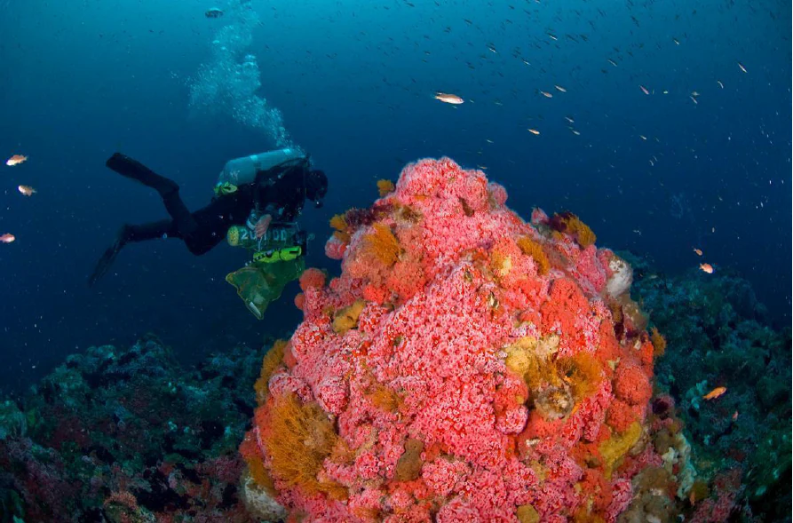
An underwater view of a research diver swimming near a large, bright pink and orange cluster of strawberry anemones on a reef.
A research diver surveys a vibrant colony of strawberry anemones in Cordell Bank National Marine Sanctuary.

Cordell Bank National Marine Sanctuary history and protected-area timeline

Cordell Bank was largely unknown to people on shore for most of human history. Indigenous peoples along the coast, including the Miwok, and later European settlers found abundant marine resources close to shore and had little reason to venture into deeper offshore waters, and many nineteenth-century mariners passed directly over the bank without realizing it existed beneath them.

The bank was first documented in 1853 during a United States Coast Survey mapping expedition led by George Davidson along the northern California coast. In 1869, Edward Cordell, the sanctuary's namesake, was sent to investigate a reported shoal west of Point Reyes and traced the area by following concentrations of feeding seabirds and marine mammals. He measured depths by lowering weighted lines to the seafloor, providing the first systematic characterization of what was understood to be a productive fishing ground.

Scientific interest in the bank expanded significantly in the late twentieth century. A 1977 expedition renewed attention to its marine life, and over the following decade the nonprofit research group Cordell Expeditions, led by Robert Schmieder, carried out extensive underwater exploration between 1978 and 1986. NOAA added a detailed multibeam echosounder survey in 1985 using the research vessel Davidson, and the resulting body of evidence about the bank's biodiversity was central to the decision to designate it as a marine sanctuary.

Cordell Bank was officially designated as a National Marine Sanctuary on May 24, 1989. In recognition of its ecological connections with neighboring waters, legislation proposed by Representative Lynn Woolsey and signed in March 2015 expanded the sanctuary along with the adjacent Gulf of the Farallones National Marine Sanctuary, extending protection further north toward Point Arena and substantially increasing the area encompassed by the protected system.

Cordell Bank National Marine Sanctuary landscape and geographic character

The defining landscape feature of the sanctuary is entirely underwater. Cordell Bank is a granite seamount that rises abruptly from the surrounding soft sediments of the continental shelf, producing a small cluster of rocky pinnacles near the surface surrounded by an otherwise flat, featureless seabed. Within just a few miles of the bank, the continental shelf gives way to waters more than a mile deep, producing a dramatic transition from shallow, light-filled rock to deep, dark ocean.

Geologically, Cordell Bank is a displaced fragment of the Sierra Nevada range. Around 93 million years ago, it was part of the ancestral Sierra Nevada, and over time, tectonic motion along the San Andreas Fault sheared sections of the mountain range northward. Cordell Bank continues to move, sliding northward by roughly an inch each year as the Pacific and North American plates grind past each other. Today the bank's exposed rocky surfaces are largely composed of granite, although softer sediments deposited by coastal erosion partially mantle the surrounding seafloor.

During the last ice age, between roughly 20,000 and 15,000 years ago, sea levels were several hundred feet lower than today, and Cordell Bank stood above the ocean as a true island. As sea levels rose following the ice age, the bank was submerged and isolated from the California mainland, leaving behind the submerged geological relic that the modern sanctuary is built around.
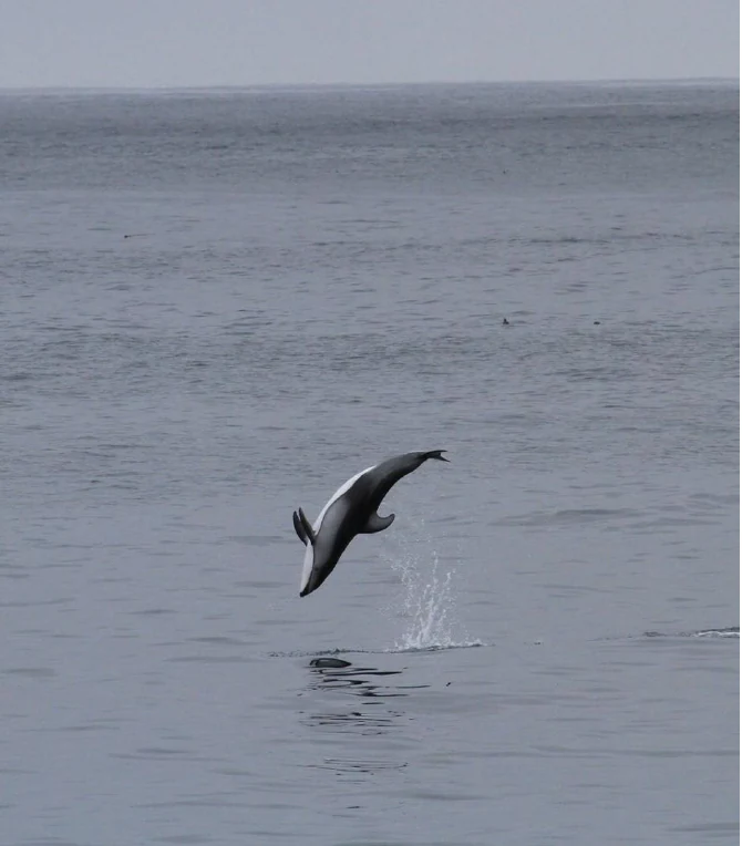
A Pacific white-sided dolphin mid-air as it leaps out of the gray ocean waters.
A Pacific white-sided dolphin breaching the ocean surface within Cordell Bank National Marine Sanctuary.

Cordell Bank National Marine Sanctuary ecosystems, habitats, and plant life

The natural character of Cordell Bank is defined by the unusual combination of shallow rocky substrate and deep surrounding water. Granite pinnacles rise from soft sediments and provide hard surfaces where invertebrates such as strawberry anemones and orange hydroids can establish dense colonies, while the surrounding seafloor remains comparatively barren and sediment-covered. Where rocky outcrops meet open sediment, habitat edges form that are unusually productive for both attached and mobile species.

The water column around the bank cycles through distinct seasonal states. Spring and early summer are dominated by upwelling, when persistent winds and the offshore influence of the California Current bring cool, nutrient-rich deep water toward the surface. These conditions fuel phytoplankton blooms that anchor the entire food web. By late summer and fall, the northward Davidson Current often takes over, replacing the upwelled water with warmer, less nutrient-rich flow. Winter storms then mix the water column again, redistributing temperature, salinity, and nutrients across the shelf.

This rhythmic shift in oceanographic conditions means that the sanctuary is not equally productive at all times of year, but rather pulses with life in predictable seasonal cycles. It is the predictability and intensity of these cycles, set against the unusual geology of the bank itself, that gives the sanctuary its distinctive ecological identity.
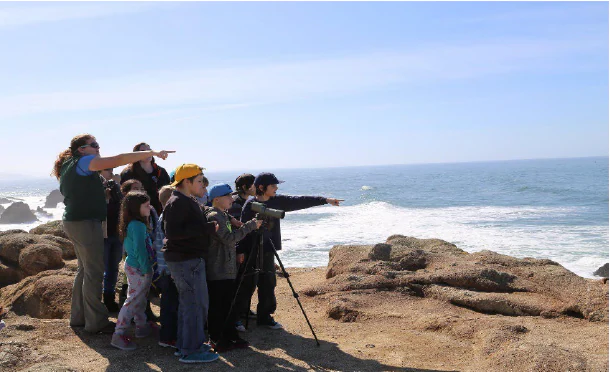
A diverse group of school-aged children and an adult guide standing on a rocky coastal cliff, looking out toward the ocean and pointing. One student is looking through a spotting scope mounted on a tripod.
A group of students on a field trip observe the ocean from a rocky shoreline.

Cordell Bank National Marine Sanctuary wildlife and species highlights

Cordell Bank supports one of the most diverse offshore wildlife communities along the continental United States. Twenty-six species of marine mammals have been documented in sanctuary waters, including several species of whales, dolphins, seals, and sea lions. The bank is especially important for the endangered blue whale and humpback whale, which travel from breeding grounds as far away as coastal Mexico and Central America to feed on the dense aggregations of krill that form around the bank during the upwelling season. Pacific white-sided dolphins can be seen in large schools, and California sea lions, northern elephant seals, northern fur seals, and Steller sea lions all visit the area to take advantage of krill, squid, and juvenile fish. Leatherback sea turtles also move through sanctuary waters.

The sanctuary is widely recognized as a globally significant seabird area. Five of the world's fourteen major albatross species have been documented at Cordell Bank, and the area has been described as a leading location for observing these ocean wanderers. The black-footed albatross and the sooty shearwater are among the most commonly seen species, and the sanctuary is also one of the few places where the extremely rare short-tailed albatross has been recorded, a species once thought to have been lost during the Second World War and now hovering at roughly a thousand individuals worldwide.

The fish community of the bank is exceptionally diverse for such a small patch of rock. More than 246 fish species have been recorded, including 44 species of rockfish that range in size from small pygmy rockfish to yelloweye rockfish that can reach three feet in length. Flatfish such as sanddabs occupy the muddy seafloor, while schools of pelagic and reef-associated fish use the rocky pinnacles as refuge from predators. Beyond its conservation significance, the bank is also valued by sport fishers who travel offshore in search of albacore and salmon.
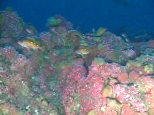
An underwater view of a rocky reef covered in colorful anemones and algae, with two small fish swimming near the surface of the reef.
A view of the diverse marine life, including rockfish and anemones, inhabiting the Cordell Bank seafloor.

Cordell Bank National Marine Sanctuary conservation status and protection priorities

Cordell Bank is conserved because it represents a rare convergence of geological and oceanographic conditions that produce an unusually concentrated offshore ecosystem. The sanctuary's protections focus on maintaining the integrity of this natural system rather than on accommodating human use of the site itself. Sanctuary regulations prohibit oil, gas, and other hydrocarbon extraction, the removal of benthic organisms, the discharge of waste, and disturbance of cultural resources, all of which could otherwise compromise the bank's ecological function.

The sanctuary is also a conservation priority because of the species that depend on it. Endangered blue and humpback whales rely on the bank as a feeding ground during their long migrations, and its krill resource helps determine their broader seasonal patterns. The presence of extremely rare seabirds such as the short-tailed albatross gives the site international recognition beyond the United States, and the rich rockfish community is part of the broader effort to maintain healthy fish populations along the West Coast.

The 2015 expansion of the sanctuary reinforced its conservation role by extending protection into adjacent waters that share ecological connections with the bank, including habitat used by the same migratory whales, seabirds, and fish. Management of the sanctuary by NOAA is intended to ensure that the underwater landscape that supports these patterns remains intact for the species that depend on it and for the long-term resilience of the broader California Current ecosystem.

Cordell Bank National Marine Sanctuary cultural meaning and human context

The human history associated with Cordell Bank is largely defined by absence and discovery. Indigenous peoples of the California coast, including the Miwok, and later European settlers found abundant resources along the shoreline and had little reason to range far offshore, leaving the bank essentially unknown to coastal cultures for centuries. Many nineteenth-century mariners passed over the bank without detecting it, and its presence was first confirmed only through deliberate scientific survey rather than traditional local knowledge.

The bank's modern identity is shaped more by science, exploration, and federal stewardship than by long-standing cultural or traditional uses. Its naming reflects the role of nineteenth-century surveyors in making the offshore California coast legible to wider society, and its protection reflects a relatively recent recognition of the ecological importance of places that had previously been beyond the reach and interest of coastal communities.

Top sights and standout views in Cordell Bank National Marine Sanctuary

Cordell Bank stands out as a marine sanctuary because of its dramatic underwater geography, where shallow granite pinnacles rise abruptly from an otherwise flat and sediment-covered continental shelf and are surrounded by water thousands of feet deep. This juxtaposition is what transforms the bank into a hotspot for whales, seabirds, and fish, and gives the sanctuary a distinctive identity among protected ocean areas.

Highlights of visiting and studying the area include the seasonal gatherings of blue and humpback whales, the international significance of the site for albatross and other seabirds, the unusually rich rockfish community around the bank's rocky pinnacles, and the rarity of a marine sanctuary that almost no casual visitor can physically enter. The site's protected status, combined with the difficulty of reaching it, has helped preserve an extraordinarily intact offshore ecosystem in close proximity to one of the most populated regions of the California coast.

Best time to visit Cordell Bank National Marine Sanctuary

The character of a visit to Cordell Bank is shaped more by offshore oceanographic cycles than by conditions on the coast. Spring and early summer are typically the most ecologically dynamic seasons, when strong winds and the California Current drive upwelling that concentrates nutrients near the surface. These conditions support the krill blooms that draw blue whales, humpback whales, and large numbers of seabirds to the bank, making this period the most favorable for whale watching and seabird observation from nearby vantage points such as the Gulf of the Farallones area or boats that venture offshore.

Late summer and fall bring warmer, less nutrient-rich water as the Davidson Current takes over, often reducing surface concentrations of feeding wildlife, although marine mammals and seabirds remain present. Winter months are marked by rough weather and frequent storms that mix the water column and can make offshore conditions more challenging. Because access to the sanctuary itself is limited and recreational diving is generally discouraged, the timing of any visit is best based on surface wildlife viewing opportunities rather than access to the underwater environment.

Monthly climate preview

Long-term temperature ranges and monthly precipitation data for Cordell Bank National Marine Sanctuary

Cordell Bank National Marine Sanctuary Climate Normals and Annual Weather Patterns

Representative point measurements reveal long-term monthly temperature and precipitation rhythms across Cordell Bank National Marine Sanctuary. Detailed twelve-month climate normals provide complete statistical context for average minimum and maximum readings.
Annual mean13 °C
11 °C15 °C
Jan11°
Feb11°
Mar11°
Apr12°
May12°
Jun13°
Jul14°
Aug15°
Sep15°
Oct15°
Nov13°
Dec11°
Warmest month
September

15.5 °C

Coolest month
January

10.8 °C

Wettest month
December

4.6 mm/day

Driest month
July

0.1 mm/day

Park location guide

Geography guide, regional context, and park location map for Cordell Bank National Marine Sanctuary

Cordell Bank National Marine Sanctuary park geography, regions, and map view in United States of America

Understand where Cordell Bank National Marine Sanctuary sits in United States of America through a broader geographic reading of the surrounding landscape, nearby location context, and its mapped position within the national park landscape.

How Cordell Bank National Marine Sanctuary fits into United States of America

The United States of America is a federal presidential republic and one of the world's largest countries by area and population. It consists of 50 states across a vast territory spanning multiple time zones, with its capital in Washington, D.C. and largest city in New York City. The nation has a diverse economy, influential political system, and significant cultural and military presence globally.

Wider geography shaping Cordell Bank National Marine Sanctuary in United States of America

The United States occupies a vast territory in North America, bordered by Canada to the north and Mexico to the south. The 48 contiguous states stretch from the Atlantic to the Pacific Ocean, while Alaska occupies the northwestern region and Hawaii is an archipelago in the Pacific. The country encompasses diverse terrain including the Rocky Mountains, Appalachian Mountains, Great Plains, and extensive river systems.

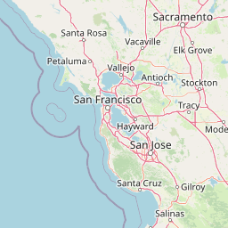
Map view of Cordell Bank National Marine Sanctuary

Use this park location map to pinpoint Cordell Bank National Marine Sanctuary in United States of America, understand its exact geographic position, and read its mapped placement within the surrounding landscape more clearly.

Pigeon | © OpenStreetMap contributors

Location context for Cordell Bank National Marine Sanctuary

California
Recorded earthquake history

Explore Historical Earthquake Records near Cordell Bank National Marine Sanctuary

Navigate through the documented history of seismic events identified within the vicinity of the sanctuary. This database assists with understanding regional activity patterns by aggregating historical earthquake data points associated with the location of Cordell Bank National Marine Sanctuary through MoriAtlas.

Cordell Bank National Marine Sanctuary Earthquake History

Catalogued events

60 events

Strongest magnitude

Magnitude 4.6

Most recent event

Sep 3, 2026

This history includes earthquakes recorded inside the park or within 50 km of its borders

Visual reference guide to offshore habitats, granite pinnacles, and marine wildlife

Cordell Bank National Marine Sanctuary Photos and Underwater Scenery

Examine professional photography and visual records documenting the underwater granite seamount and pelagic environment of Cordell Bank National Marine Sanctuary. Visual reference materials reveal the unique topography of shallow rocky pinnacles rising above deep continental shelf waters.

An underwater view of a research diver swimming near a large, bright pink and orange cluster of strawberry anemones on a reef.

A tufted puffin with distinctive white facial patches and an orange beak swimming in choppy dark ocean water with its wings partially spread.

A Pacific white-sided dolphin mid-air as it leaps out of the gray ocean waters.

A diverse group of school-aged children and an adult guide standing on a rocky coastal cliff, looking out toward the ocean and pointing. One student is looking through a spotting scope mounted on a tripod.

An underwater view of a rocky reef covered in colorful anemones and algae, with two small fish swimming near the surface of the reef.

Park atlas

Compare regional marine reserves, coastal topography, and offshore sanctuaries.

Other Parks Near Cordell Bank National Marine Sanctuary and Protected Areas

Browsing other parks near Cordell Bank National Marine Sanctuary reveals connected marine reserves, coastal habitats, and offshore protected areas across the region. Evaluating these neighboring marine landscapes provides valuable geographic context for understanding Pacific continental shelf ecosystems.
Marine protected areaCalifornia
Park boundaries overlap#1 closest

Southeast

Greater Farallones National Marine Sanctuary: Protected Marine Geography and Atlas Data

Essential marine protected area off the coast of California.

Greater Farallones National Marine Sanctuary protects a vital network of oceanic habitats off California, including sandy beaches, tidal flats, subtidal reefs, and open ocean waters. This marine protected area serves as a critical link in the Pacific coast's network of conservation landscapes, offering a deep look at the geographic connectivity between coastal estuaries and offshore continental shelf environments.

Area
8,530 km²
Established
1981
Relief
Lowland
Climate
Mediterranean
Watercolor painting of soft, rolling green hills and landscape against a pale background.
Protected landscapeMarin County
9.7 km away#2 closest

East

Point Reyes National Seashore: Exploring the Protected Landscapes of Marin County

Geology, coastal estuaries, and Pacific wilderness boundaries

Point Reyes National Seashore offers a deep look into California coastal geography. The protected area features the dramatic San Andreas Fault, expansive Douglas-fir forests, and rich estuarine habitats, providing an essential study of maritime conservation landscapes and rare breeding grounds for elephant seals and tule elk.

Area
287.44 km²
Established
1962
IUCN
V
Visitors
2.3M annual
A soft watercolor painting of a shoreline with gentle green hills and pale purple water against a white background.
Marine protected areaCalifornia
38 km away#3 closest

Southeast

Monterey Bay National Marine Sanctuary: California Marine Protected Area and Coastal Atlas

Mapping deep submarine canyons and expansive Pacific coastal ecosystems.

Monterey Bay National Marine Sanctuary represents one of the most biologically significant marine protected areas in the United States. Spanning 276 miles of California shoreline, the sanctuary encompasses varied aquatic terrain including towering kelp forests, rocky reefs, and the massive Monterey Submarine Canyon. This protected marine landscape serves as a crucial region for oceanic research and environmental conservation.

Area
15,780 km²
Established
1992
Relief
Mixed relief
Climate
Mediterranean
A horizontal watercolor painting showing a rolling landscape with a pond in the foreground, small hills in the background, and soft-colored wildflowers on the banks.
Protected landscapeCalifornia
About 62 km away#4 closest

East

Golden Gate National Recreation Area: A Mapped Protected Landscape in California

Coastal geography and historical park terrain overview

An expansive network of protected lands encompassing Pacific shorelines, Marin headlands, and urban forest ecosystems. This recreation area provides a detailed look at the geographic connectivity between coastal redwood groves, military fortifications, and restored wetland corridors within the California Bay Area region.

Area
332.31 km²
Established
1972
IUCN
V
Visitors
15M annual
A watercolor illustration showing a soft, panoramic view of green trees and rolling hills against pale, pinkish-yellow mountains in the background.
Protected landscapeCalifornia
94 km away#5 closest

North

Mendocino National Forest: Mapping California's Remote Protected Mountain Landscape

Examining wilderness boundaries and rugged coastal terrain

Mendocino National Forest serves as a significant protected area in California, known for being the only national forest in the state without major paved access. Its terrain spans 913,000 acres of mountain peaks, deep river canyons, and old-growth conifer forests. Home to the unique tule elk population at Lake Pillsbury, this landscape provides a rare example of wilderness isolation, complex geothermal features, and rugged, largely untouched northern coastal topography.

Area
3,696.02 km²
Established
1907
Relief
Mountain
Climate
Mediterranean
Watercolor illustration of a low lying marsh landscape with distant soft pink hills and green vegetation under a white background.
Nature reserveCalifornia
About 181 km away#6 closest

Southeast

Elkhorn Slough National Estuarine Research Reserve: Protected Landscapes and Coastal Geography

Mapping the tidal ecosystems of Monterey Bay, California

Located near Watsonville, California, this nature reserve protects a vital estuarine ecosystem marked by tidal channels, mudflats, and oak woodlands. It functions as a key site for coastal research, providing a clear window into the ecology and protected terrain of one of the largest salt marshes remaining on the California coastline.

Area
6.9 km²
Relief
Lowland
Climate
Mediterranean
Access
Easy access
Watercolor painting of a peaceful river landscape, featuring rolling green hills, dense trees, and distant soft-toned mountains.
Protected areaCalifornia
191 km away#7 closest

North

Six Rivers National Forest: Exploring Protected River Valleys and Mountain Terrain in California

A regional protected area spanning California river systems

Six Rivers National Forest defines much of the rugged landscape in northwestern California. Named for the six major river drainages within its borders, the area features a unique combination of coastal forests, deep river canyons, and high-country ridges that offer significant insight into the region's broader geographic and ecological character.

Area
3,875.2 km²
Established
1947
Relief
Mountain
Climate
Mediterranean
A soft watercolor painting depicting a serene landscape with gentle green hills, a small forest, and a calm lake at sunrise or sunset.
Protected landscapeCalifornia
198 km away#8 closest

North

Shasta, Trinity National Forest: Mapping the Protected Landscapes of Northern California

Volcanic peaks, expansive reservoirs, and rugged mountain wilderness

Spanning over two million acres, Shasta, Trinity National Forest represents a major protected landscape in Northern California. The geography includes the iconic Mount Shasta volcano and the complex shoreline of Shasta Lake, while hosting expansive wilderness areas and diverse terrain ranging from oak-forested foothills to alpine meadows.

Area
8,942.87 km²
Established
1954
Relief
Mountain
Climate
Temperate

Common questions about visiting, size, designation, and location context for Cordell Bank National Marine Sanctuary

Cordell Bank National Marine Sanctuary FAQs for park facts, access, geography, and protected area context

Find quick answers about Cordell Bank National Marine Sanctuary, including protected-area facts, park geography, trail and visitor context, and how the park fits into its surrounding country and regional landscape.
MoriAtlas Explorer

Continue Your Protected Areas Search Across the Global Atlas

Deepen your exploration by continuing the structured search for national parks and protected areas worldwide. Utilize the comprehensive filtering capabilities to compare different conservation landscapes and refine your understanding of global park geography. Discover more about the distribution and characteristics of protected natural areas.

Global natural geography