

Mori Atlas logo
Wildlife reserveCrater Mountain Wildlife Management Area

A critical conservation refuge of continuous montane rainforest and rugged central cordillera terrain.

Crater Mountain Wildlife Management Area: Mapped Protected Landscapes in the Chimbu Province Highlands

Crater Mountain Wildlife Management Area represents a significant protected expanse located within the central highlands of Papua New Guinea. The landscape consists of steep, forested ridges and deep valleys, creating a complex altitudinal gradient that supports rich rainforest ecosystems. This wildlife reserve serves as a vital natural corridor in the Chimbu Province, maintaining intact forest cover that anchors the broader biodiversity of the central cordillera through community-linked stewardship.

wildlife management areahighland rainforesttropical forestmontane forestPapua New GuineaChimbu Province

Crater Mountain Wildlife Management Area

Wildlife reserve

Park overview

Structured park overview, official facts, and landscape profile for Crater Mountain Wildlife Management Area

Crater Mountain Wildlife Management Area park facts, protected area profile, and essential visitor context

Review the core facts for Crater Mountain Wildlife Management Area, including designation, size, terrain, visitor scale, habitats, and operating context in one park-focused overview.

About Crater Mountain Wildlife Management Area

Crater Mountain Wildlife Management Area occupies a significant block of forested mountain landscape in Chimbu Province, in the central highlands of Papua New Guinea. The reserve lies far inland from the country's coastal capital region, in a part of the country defined by steep ridges, deep river valleys, and dense rainforest that climbs from low elevations into the cooler montane zone. Its position in the central cordillera places it squarely within one of the most biologically rich forest landscapes in the world, a region long recognized for its exceptional diversity of plants, birds, and mammals.

Within Papua New Guinea's system of protected areas, Crater Mountain occupies a distinctive role as a wildlife management area rather than a strictly designated national park. Wildlife management areas in Papua New Guinea are typically established in partnership with customary landowners and managed to balance habitat protection, sustainable use, and the needs of local communities. This designation reflects the reserve's emphasis on ongoing stewardship of the forest by the people who live within and around it, rather than on the more restricted tourism-or-research focus of some other protected-area categories.

The reserve's remote setting and the ruggedness of the surrounding terrain have contributed to the maintenance of large, relatively intact forest tracts. Continuous forest cover across variable elevation creates habitat gradients that are particularly important for species tied to specific altitudinal or ecological niches. From this perspective, Crater Mountain is not simply a single landscape feature but rather a broad highland forest landscape whose ecological value emerges from its scale, its connectivity, and the persistence of rainforest under comparatively limited direct human pressure.

Quick facts and research context for Crater Mountain Wildlife Management Area

Crater Mountain Wildlife Management Area is situated in Chimbu Province in the central highlands of Papua New Guinea, well inland from Port Moresby. The reserve occupies rugged mountainous terrain within Papua New Guinea's central cordillera, where elevation, rainfall, and forest cover combine to create conditions favorable for tropical and montane rainforest biodiversity. Although it is classified as a wildlife management area rather than a national park, it serves a similar conservation purpose by protecting a significant block of highland forest habitat in one of the world's most biodiverse regions.

Park context

Deeper park guide and search-rich context for Crater Mountain Wildlife Management Area

Crater Mountain Wildlife Management Area history, landscape, wildlife, and travel context

Explore Crater Mountain Wildlife Management Area through its history, landscape character, ecosystems, wildlife, conservation priorities, cultural context, and seasonal travel timing in a structured park guide built for atlas discovery and search intent.

Why Crater Mountain Wildlife Management Area stands out

Crater Mountain Wildlife Management Area is best known for its expanse of relatively undisturbed highland rainforest in the central cordillera of Papua New Guinea. The reserve's combination of remote mountainous geography, continuous forest cover, and central highland position gives it particular importance as habitat for rainforest biodiversity in a region recognized globally for its species richness and endemism. It also stands out as one of the well-known community-linked conservation areas in Papua New Guinea, where local landowners have played a role in protecting forest and wildlife habitat.

Crater Mountain Wildlife Management Area history and protected-area timeline

Crater Mountain Wildlife Management Area emerged as part of Papua New Guinea's evolving approach to conserving its extensive rainforest landscapes through agreements with customary landowners. Wildlife management areas in the country are generally established through partnerships between conservation organizations, government agencies, and local communities, recognizing that the long-term protection of highland forest depends on the involvement of the people who hold traditional rights over the land. In this broader context, Crater Mountain became recognized as an important example of how community-led conservation arrangements could help safeguard substantial areas of rainforest in the central highlands.

Crater Mountain Wildlife Management Area landscape and geographic character

The landscape of Crater Mountain Wildlife Management Area is defined by the steep, forested terrain of Papua New Guinea's central highlands. Rugged ridges rise above deeply incised valleys, and the topography transitions across elevations that support a clear gradient from warmer lowland rainforest conditions to cooler, mist-prone montane forest. This altitudinal variety gives the reserve a layered physical character, with shifting vegetation, cloud cover, and microclimates that change over relatively short distances.

The reserve's central highland position means that the landscape is shaped by heavy rainfall, persistent moisture, and the erosional forces that have carved the region's river systems over time. Streams and rivers descend through the forest from the higher ridges, contributing to the humid conditions that sustain the dense vegetation cover across the area. Viewed more broadly, the Crater Mountain landscape reads as a continuous block of mountainous rainforest, its individual features forming parts of a much larger wilderness matrix that extends across the central cordillera.

Crater Mountain Wildlife Management Area ecosystems, habitats, and plant life

Ecologically, Crater Mountain Wildlife Management Area lies within the central highland rainforest belt of Papua New Guinea, a region recognized as among the most biodiverse on Earth. The reserve's habitat structure is dominated by closed-canopy tropical and montane rainforest, with vegetation patterns shaped strongly by elevation, rainfall, and slope. Lower and mid-elevations typically support tall, structurally complex tropical forest, while higher elevations transition into mossy montane forest characterized by smaller trees, denser understory, and frequent cloud immersion.

This altitudinal gradient creates conditions for a wide range of forest types and microhabitats within a single landscape. Fallen logs, moss-covered trunks, and dense understory layers provide shelter and feeding grounds for forest-floor species, while the canopy supports arboreal animals and birds tied to mature forest conditions. The persistence of large continuous forest blocks across the reserve is ecologically important, because many rainforest species depend on extensive, undisturbed habitat to maintain viable populations. The reserve therefore functions less as an isolated patch and more as a meaningful component of a wider central highland forest network.

Crater Mountain Wildlife Management Area wildlife and species highlights

The wildlife significance of Crater Mountain Wildlife Management Area lies in its role as a refuge for species associated with the central highland forests of Papua New Guinea. As elsewhere in the country's central cordillera, the reserve's mature rainforest habitats support a wide array of forest-dependent fauna, including birds, mammals, reptiles, and insects tied to closed-canopy conditions. The combination of elevation gradients and intact forest cover provides habitat for species that require specialized niches, whether in the canopy, the understory, or along the forest floor.

Papua New Guinea as a whole is renowned for its high levels of endemism, particularly among birds of paradise, cassowaries, parrots, and other forest-dwelling groups that find suitable habitat in extensive rainforest blocks like Crater Mountain. The reserve's relatively undisturbed forest condition, combined with its remoteness from major population centers, makes it a place where wildlife patterns can reflect natural forest processes more closely than in more heavily altered landscapes. This context gives the area broader conservation relevance, even where detailed species inventories remain limited outside of specific survey efforts.

Crater Mountain Wildlife Management Area conservation status and protection priorities

From a conservation perspective, Crater Mountain Wildlife Management Area represents an important block of protected highland rainforest in one of the world's most biodiverse countries. Its designation as a wildlife management area reflects a conservation model that emphasizes long-term collaboration with customary landowners, recognizing that the future of Papua New Guinea's forests depends heavily on the willingness and capacity of local communities to maintain them as living landscapes. This makes the reserve both a biodiversity refuge and a working example of community-based conservation in a Melanesian context.

The reserve's ecological value rests on the persistence of large, connected rainforest tracts across variable elevation, which supports habitat for many forest-dependent species and helps maintain broader ecological processes such as watershed protection and forest regeneration. By keeping significant forest cover intact in a region where population growth and land use change are ongoing pressures, Crater Mountain contributes to the resilience of the central highland forest landscape as a whole. In this way, its conservation significance extends beyond its boundaries into the wider central cordillera.

Crater Mountain Wildlife Management Area cultural meaning and human context

Crater Mountain Wildlife Management Area is embedded in a region of Papua New Guinea where customary land tenure and traditional forest relationships remain central to everyday life. Local communities in Chimbu Province and surrounding highland areas have long histories of interaction with the mountain forests, drawing on them for subsistence, materials, and cultural meaning. The wildlife management area model formally recognizes this relationship by placing customary landowners at the center of conservation decision-making rather than treating the land purely as a state-managed reserve.

This cultural framing distinguishes Crater Mountain from protected areas established primarily around scientific research, tourism, or strict nature preservation. Instead, the reserve reflects a vision of conservation in which forest protection and community continuity are seen as mutually reinforcing, and in which the cultural identity of highland Papua New Guinean communities remains closely tied to the health of the surrounding forest landscape.

Top sights and standout views in Crater Mountain Wildlife Management Area

Crater Mountain Wildlife Management Area stands out for its large, contiguous expanse of central highland rainforest, set within a remote and rugged stretch of Papua New Guinea's cordillera. Its altitudinal range and intact forest cover give it strong habitat value for species tied to tropical and montane conditions, while its wildlife management area status reflects an inclusive, community-grounded approach to long-term forest protection. The reserve's combination of remoteness, biodiversity significance, and local stewardship makes it a notable example of Papua New Guinea's distinctive conservation landscape.

Best time to visit Crater Mountain Wildlife Management Area

The highland setting of Crater Mountain Wildlife Management Area means that the climate is generally cooler and wetter than the lowlands of Papua New Guinea, with rainfall distributed throughout the year. Seasons in the central highlands are less sharply defined than in many other parts of the country, but periods of relatively drier weather can make forest travel and fieldwork more manageable. As a remote and rugged area, any visit tends to depend heavily on local conditions, and the cooler highland climate means that temperatures remain moderate compared with the coastal lowlands.

Monthly climate preview

Long-term temperature ranges and monthly precipitation cycles across representative terrain

Crater Mountain Wildlife Management Area Climate Normals and Annual Weather Patterns

Representative coordinate records show measured monthly temperature variations and precipitation cycles spanning twelve distinct periods at Crater Mountain Wildlife Management Area. Analyzing the complete monthly climate dataset provides deeper insight into long-term averages and multi-month environmental patterns.
Annual mean20 °C
19 °C20 °C
Jan20°
Feb20°
Mar20°
Apr20°
May20°
Jun19°
Jul19°
Aug19°
Sep20°
Oct20°
Nov20°
Dec20°
Warmest month
December

20.2 °C

Coolest month
July

18.8 °C

Wettest month
March

7.3 mm/day

Driest month
August

2 mm/day

Park location guide

Geography guide, regional context, and park location map for Crater Mountain Wildlife Management Area

Crater Mountain Wildlife Management Area park geography, regions, and map view in Papua New Guinea

Understand where Crater Mountain Wildlife Management Area sits in Papua New Guinea through a broader geographic reading of the surrounding landscape, nearby location context, and its mapped position within the national park landscape.

How Crater Mountain Wildlife Management Area fits into Papua New Guinea

Papua New Guinea is an island nation in the southwestern Pacific Ocean, comprising the eastern half of the island of New Guinea and hundreds of offshore islands. It gained independence from Australia in 1975 and operates as a constitutional monarchy within the Commonwealth. The country is renowned for having the world's highest linguistic diversity, with over 840 known languages.

Wider geography shaping Crater Mountain Wildlife Management Area in Papua New Guinea

Papua New Guinea occupies the eastern half of the island of New Guinea and hundreds of smaller islands in Melanesia. It shares a land border with Indonesia to the west and has maritime boundaries with Australia to the south and the Solomon Islands to the east. The terrain is predominantly mountainous, with the land supporting extraordinary biodiversity.

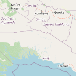
Map view of Crater Mountain Wildlife Management Area

Use this park location map to pinpoint Crater Mountain Wildlife Management Area in Papua New Guinea, understand its exact geographic position, and read its mapped placement within the surrounding landscape more clearly.

Pigeon | © OpenStreetMap contributors

Location context for Crater Mountain Wildlife Management Area

Chimbu Province
Park atlas

Compare regional mountain terrain, continuous highland rainforest, and connected conservation areas.

Explore Other Parks Near Crater Mountain Wildlife Management Area and Surrounding Protected Landscapes

Browse nearby national parks and protected areas sharing the rugged terrain of the central cordillera. Comparing adjacent highland habitats provides broader context on regional forest conservation and biodiversity.
Stylized illustration of a mountain with waterfalls, river, and trees under a bright sky with clouds
Protected areaPapua New Guinea
About 101 km away#1 closest

North

Mount Wilhelm Protected Area: Papua New Guinea's Highest Peak and Alpine Terrain

Mapped geography and protected landscape context for a key Oceania peak.

Mount Wilhelm represents a significant protected area and the highest mountain in Papua New Guinea. Situated within the Bismarck Range, its dramatic granite peak defines a unique alpine environment, transitioning from dense rainforests to high-altitude grasslands. The presence of twin glacial lakes, Piunde and Aunde, adds to its distinctiveness, offering insight into the region's varied natural terrain and its role as a key geographical landmark.

Relief
Mountain
Climate
Alpine
Access
Moderate access
Scope
Terrestrial
Nature reserveWestern Highlands Province
About 163 km away#2 closest

Northwest

Baiyer River Sanctuary: Protected Highland Rainforest and River Valley Geography

Nature reserve in the Western Highlands Province of Papua New Guinea.

Located within the Western Highlands, Baiyer River Sanctuary protects 740 hectares of dense oak-dominated rainforest. This nature reserve provides essential habitat for birds-of-paradise, maintaining a continuous canopy across high-rainfall mountain slopes that bridges the transition between lowland and alpine ecosystems.

Area
7.4 km²
Established
1968
Relief
Upland
Climate
Tropical
Wildlife reserveSouthern Highlands Province
About 188 km away#3 closest

West

Lake Kutubu Wildlife Reserve: Geographic Boundaries and Highland Ecosystem Mapping

Protected freshwater terrain in the Southern Highlands Province

Lake Kutubu represents an essential protected landscape in the Papua New Guinea highlands, serving as a critical upland basin for diverse freshwater species. This overview highlights the reserve's unique geographic setting, covering its expansive 19-kilometer stretch, surrounding montane forests, and its role within the Kikori River catchment. Access detailed landscape context and regional environmental data for this globally significant lacustrine ecosystem.

Area
51.84 km²
Relief
Mountain
Scope
Terrestrial
Water
Water-dominated
National parkMorobe Province
About 190 km away#4 closest

East

McAdam National Park; Geographic Atlas of Protected Highland Forests in Morobe Province

Highland montane forest and rugged ridge landscapes

McAdam National Park preserves a rugged stretch of montane rainforest in Papua New Guinea's Bulolo region. Rising over 1,200 meters, this protected area features steep forested slopes and narrow valleys that define the geography of the Morobe interior. Our atlas provides insights into the park's boundaries and its position within the broader highland ecosystem of the province.

Relief
Mountain
Scope
Terrestrial
Water
Minor water
Wildlife reserveMorobe Province
About 219 km away#5 closest

Northeast

YUS Conservation Area: Mapping the Geographic Range of a Community-Led Wildlife Reserve

Protected tropical forest landscapes in Morobe Province, Papua New Guinea

YUS Conservation Area represents a significant shift in regional conservation, protecting a massive altitudinal gradient on the Huon Peninsula. From coastal coral reef environments to the rugged ridges of the Saruwaged Mountains, the area preserves critical montane habitats and riverine corridors. This dataset provides insight into its unique geography, spanning lowland forests to highland peaks while showcasing a model of land management driven by customary community agreements.

Area
760 km²
Established
2009
Relief
Mountain
Climate
Tropical
National parkCentral Province
About 398 km away#6 closest

Southeast

Varirata National Park: Protected Rainforest and Highland Terrain Atlas

Mapped geography of Central Province rainforest reserves

Varirata National Park is a significant protected area within the Central Province of Papua New Guinea, known for its elevated tropical rainforest ridges and varied topography. This map-based entry provides context on its landscape character, environmental setting, and role as an essential forest refuge in the highlands near the national capital.

Relief
Highland
Water
Minor water
A wide watercolor illustration showing green hills in the distance, a body of shallow water with pink and green patches, and foreground vegetation including green grasses and pink coral-like structures.
Marine protected areaQueensland
About 439 km away#7 closest

South

Great Barrier Reef Marine Park: Atlas and Geographic Context for Queensland Protected Waters

Exploring the reef system and marine conservation zones in northeastern Australia

The Great Barrier Reef Marine Park stands as an internationally significant marine protected area. By spanning a massive stretch of the Queensland coast, this protected landscape provides a critical framework for marine governance and reef conservation. Users can examine the unique zoning and distribution of coral reef habitats that define this extensive tropical ecosystem.

Area
343,966 km²
Established
1975
Climate
Tropical
Scope
Marine
Wildlife reserveWestern Province
About 457 km away#8 closest

Southwest

Tonda Wildlife Management Area: Atlas of Protected Wetlands and Savanna Landscapes

Geographic overview of Papua New Guinea's largest wetland conservation zone

Spanning nearly 6,000 square kilometres of floodplain, Tonda Wildlife Management Area is defined by its exceptionally flat terrain and shifting mosaic of monsoon forest, tidal channels, and freshwater marshes. This protected landscape functions as an essential ecological bridge within the Trans-Fly ecoregion, maintaining deep connections to international conservation partners while preserving the integrity of its native bird and mammal habitats.

Area
5,900 km²
Established
1975

Common questions about visiting, size, designation, and location context for Crater Mountain Wildlife Management Area

Crater Mountain Wildlife Management Area FAQs for park facts, access, geography, and protected area context

Find quick answers about Crater Mountain Wildlife Management Area, including protected-area facts, park geography, trail and visitor context, and how the park fits into its surrounding country and regional landscape.
MoriAtlas Explorer

Continue Your Protected Areas Search Across the Global Atlas

Deepen your exploration by continuing the structured search for national parks and protected areas worldwide. Utilize the comprehensive filtering capabilities to compare different conservation landscapes and refine your understanding of global park geography. Discover more about the distribution and characteristics of protected natural areas.

Global natural geography

