Mori Atlas logo
Protected areaCuenca Alimentadora del Distrito Nacional de Riego 01 Pabellón

Mapping the forested watersheds and highland terrain of the southeastern Sierra Madre Occidental

Cuenca Alimentadora del Distrito Nacional de Riego 01 Pabellón Protected Area Geography

Cuenca Alimentadora del Distrito Nacional de Riego 01 Pabellón encompasses 977 square kilometers of rugged terrain across the Sierra Fría mountain range in central Mexico. This protected landscape functions as a critical forested watershed, regulating water flow from high-altitude pine oak woodlands and montane grasslands down toward the Rio Verde basin. Its protected boundaries capture a distinct ecological gradient where the volcanic Sierra Madre Occidental meets the semi-arid Mexican Plateau.

pine-oak forestsierra friasierra madre occidentalwatershed reservecentral mexicoaguascalientes

Cuenca Alimentadora del Distrito Nacional de Riego 01 Pabellón

Protected area

Park overview

Structured park overview, official facts, and landscape profile for Cuenca Alimentadora del Distrito Nacional de Riego 01 Pabellón

Cuenca Alimentadora del Distrito Nacional de Riego 01 Pabellón park facts, protected area profile, and essential visitor context

Review the core facts for Cuenca Alimentadora del Distrito Nacional de Riego 01 Pabellón, including designation, size, terrain, visitor scale, habitats, and operating context in one park-focused overview.

About Cuenca Alimentadora del Distrito Nacional de Riego 01 Pabellón

The Cuenca Alimentadora del Distrito Nacional de Riego 01 Pabellón is a large protected natural area in central Mexico, anchored in the rugged terrain of the Sierra Fría. The Sierra Fría is the southeasternmost expression of the Sierra Madre Occidental, the long volcanic spine that runs along Mexico's western edge, and where this range meets the Mexican Plateau it forms a highland landscape of canyons, forested slopes, and grassy ridges.

Geographically, the reserve occupies the eastern side of the Sierra Fría and captures the basin of the Río Verde, which flows southward toward the Río Grande de Santiago. A companion protected area, Cuenca Alimentadora del Distrito Nacional de Riego 043 Estado de Nayarit, covers the western flank drained by the Juchipila River, and together the two reserves encompass most of the Sierra Fría's forested watersheds. The protection area spans ten municipalities across Aguascalientes and Zacatecas, including Calvillo, Jesús María, Pabellón de Arteaga, Rincón de Romos, San José de Gracia, Cuauhtémoc, Genaro Codina, Guadalupe, Ojocaliente, and Villanueva, giving it a significant regional footprint.

Ecologically, the reserve traces a vertical gradient from dry Central Mexican matorral at lower levels up into pine–oak forests and woodlands on the higher slopes, with montane grasslands occupying exposed canyon faces and manzanillo thickets reasserting themselves in logged areas. This mosaic supports a varied fauna typical of the Sierra Madre Occidental pine–oak forests ecoregion, including large mammals, raptors, ground-dwelling quail, and several rattlesnake species. Pine–oak woodland of this kind is recognized as among the most biodiverse temperate forest systems in Mexico, and the reserve's protected status helps maintain habitat continuity across an important portion of that range.

As a designated natural resources protection area, the Cuenca Alimentadora del Distrito Nacional de Riego 01 Pabellón also functions as an IUCN Category VI landscape, where conservation objectives coexist with controlled human activities. Hiking, horseback riding, mountain biking, and nature walks are allowed, and regulated hunting and sport fishing are permitted with prior authorization, reflecting the dual role of the area as both an ecological refuge and a working watershed feeding one of Mexico's national irrigation districts.

Quick facts and research context for Cuenca Alimentadora del Distrito Nacional de Riego 01 Pabellón

The Cuenca Alimentadora del Distrito Nacional de Riego 01 Pabellón is a Mexican natural resources protection area covering about 97,700 hectares in two separate blocks across Aguascalientes and Zacatecas. It lies within the Sierra Fría, the southeasternmost range of the Sierra Madre Occidental where it meets the Mexican Plateau, and protects the headwaters that feed the Río Verde, a tributary of the Río Grande de Santiago. Designated in 2002 and administered by the National Commission of Natural Protected Areas, it is classified as an IUCN Category VI protected area with sustainable use of natural resources.

Protection and recognition

Documented terrestrial protection history and designation records

Cuenca Alimentadora del Distrito Nacional de Riego 01 Pabellón Protection Status

Terrestrial protection status for Cuenca Alimentadora del Distrito Nacional de Riego 01 Pabellón was established in 2002 under verified governance frameworks. Official records organize management scope and designation history without imported international recognition sources.

Protection details

Protection scope
Terrestrial
Designated year
2002
Transboundary protection
No
Park context

Deeper park guide and search-rich context for Cuenca Alimentadora del Distrito Nacional de Riego 01 Pabellón

Cuenca Alimentadora del Distrito Nacional de Riego 01 Pabellón history, landscape, wildlife, and travel context

Explore Cuenca Alimentadora del Distrito Nacional de Riego 01 Pabellón through its history, landscape character, ecosystems, wildlife, conservation priorities, cultural context, and seasonal travel timing in a structured park guide built for atlas discovery and search intent.

Why Cuenca Alimentadora del Distrito Nacional de Riego 01 Pabellón stands out

The reserve is best known for protecting the forested headwaters of a major national irrigation district within one of Mexico's distinctive highland ecosystems. The Sierra Fría's pine, oak woodlands, montane grasslands, and dry matorral create a layered ecological mosaic where elevations, rainfall, and soils combine to support numerous plant and animal species, including several endemic or limited-range taxa. Wildlife values such as puma, white-tailed deer, golden eagle, peregrine falcon, and Montezuma quail give the protected area a strong faunal identity rooted in the Sierra Madre Occidental. Equally important is the reserve's role as a working watershed: its forests regulate runoff that sustains agriculture far downstream, blending biodiversity protection with the practical demands of water management.

Cuenca Alimentadora del Distrito Nacional de Riego 01 Pabellón history and protected-area timeline

The Cuenca Alimentadora del Distrito Nacional de Riego 01 Pabellón has a protection history that stretches back more than half a century. In August 1949, the area was first designated as a protected forest and watershed, recognizing the importance of its forests for regulating water flow into the irrigation district it serves. This early protective status laid the foundation for the reserve's enduring identity as a landscape valued primarily for the ecosystem services its forests provide.

In 2002, the area was redesignated as a Natural Resources Protection Area under Mexico's federal protected areas framework, administered by the National Commission of Natural Protected Areas (CONANP). This redesignation aligned the reserve with the country's modern system of categorized protections and gave it the standardized IUCN Category VI classification that reflects its combined conservation and sustainable-use mandate.

The reserve's name itself reflects its practical origin: it is the upstream catchment, or cuenca alimentadora, that supplies the Distrito Nacional de Riego 01 Pabellón, one of Mexico's designated national irrigation districts. From the outset, management has therefore balanced watershed protection, biodiversity conservation, and the continuation of traditional recreational and extractive uses such as regulated sport hunting and fishing.

Cuenca Alimentadora del Distrito Nacional de Riego 01 Pabellón landscape and geographic character

The landscape of the Cuenca Alimentadora del Distrito Nacional de Riego 01 Pabellón is defined by the Sierra Fría, a rugged highland range that marks the southeastern end of the Sierra Madre Occidental. Within the reserve, the terrain rises from lower slopes clothed in dry shrubland to forested ridges and canyon systems that drop steeply toward the Río Verde basin, producing the kind of topographic relief that shapes both local climate and vegetation patterns.

Two separate blocks of land make up the protected area, together totaling approximately 977 square kilometers. The reserve captures the eastern drainage of the Sierra Fría, with waters flowing south via the Río Verde toward the Río Grande de Santiago. On the opposite side of the range, the adjoining protected area along the Juchipila River mirrors this drainage role, so the two reserves together frame the Sierra Fría as a single forested watershed complex.

The physical setting is shaped by the meeting of two major Mexican landforms: the volcanic uplift of the Sierra Madre Occidental and the broad, semi-arid expanse of the Mexican Plateau. This geological transition creates steep altitudinal gradients, deep canyons, and a mosaic of exposed slopes and sheltered valleys that give the reserve much of its scenic and ecological character.

Cuenca Alimentadora del Distrito Nacional de Riego 01 Pabellón ecosystems, habitats, and plant life

The natural environment of the reserve is organized around elevation, moisture, and soil, producing a layered set of habitats typical of the Sierra Madre Occidental pine–oak forest ecoregion. At higher elevations, pine–oak forests and woodlands dominate the landscape, with pines and oaks as the principal trees accompanied by manzanillo (Arbutus species), juniper, and a varied understory of shrubs and herbaceous plants. The composition of these forests shifts with rainfall, altitude, and substrate, supporting a diverse plant community that includes endemic and limited-range species.

Where forests have been logged, manzanillo often responds by forming dense secondary thickets, highlighting the resilience of certain shrub species in the area. On exposed canyon slopes and in cooler, drier pockets, montane grasslands take over, creating open habitats that contrast sharply with the surrounding woodlands. Lower elevations, where conditions become warmer and drier, support Central Mexican matorral, a thorny and drought-adapted shrubland characteristic of much of central Mexico's semi-arid zone.

Altogether, the reserve encompasses a gradient from semi-arid matorral through montane grassland and manzanillo thickets into fully developed pine–oak forest, capturing in a single protected area the ecological transitions that define the southern Sierra Madre Occidental.

Cuenca Alimentadora del Distrito Nacional de Riego 01 Pabellón wildlife and species highlights

The Cuenca Alimentadora del Distrito Nacional de Riego 01 Pabellón supports a rich community of mammals, birds, and reptiles typical of Mexico's pine–oak highlands. White-tailed deer (Odocoileus virginianus) are a characteristic large herbivore of the area, and they share the forested slopes with puma (Puma concolor) and collared peccary (Dicotyles tajacu), both of which depend on extensive tracts of intact habitat to persist in meaningful numbers.

Smaller carnivores and omnivores such as the ringtail (Bassariscus astutus) and gray fox (Urocyon cinereoargenteus) occupy the more wooded and rocky portions of the reserve, exploiting the canyons and dense thickets for cover and prey. The mosaic of open montane grassland and pine–oak woodland also provides excellent hunting conditions for raptors, and the reserve hosts both golden eagle (Aquila chrysaetos) and peregrine falcon (Falco peregrinus), two species associated with rugged, relatively undisturbed mountain terrain.

On the ground, Montezuma quail (Cyrtonyx montezumae) is one of the most distinctive resident birds, closely tied to the oak-dominated slopes and montane grasslands of the Sierra Madre Occidental. Reptile life is represented by rattlesnake species including Crotalus polystictus and Crotalus triseriatus, both of which occupy the rocky, well-vegetated habitats within the reserve. Together, these species sketch a wildlife profile dominated by the larger and more conspicuous elements of central Mexico's highland fauna.

Cuenca Alimentadora del Distrito Nacional de Riego 01 Pabellón conservation status and protection priorities

The reserve's conservation value lies at the intersection of watershed protection and biodiversity preservation. Its forests regulate the runoff that feeds the national irrigation district it is named after, making the protection of soil, vegetation cover, and water quality a direct contribution to agricultural productivity far downstream. By securing the upper catchments of the Río Verde, the reserve helps stabilize stream flow in a region where water is a limiting resource.

From a biodiversity perspective, the area safeguards a significant block of Sierra Madre Occidental pine–oak forest and woodland, an ecoregion recognized for its exceptional plant species richness and endemicity in Mexico. The combination of pine–oak forest, montane grassland, manzanillo thickets, and Central Mexican matorral supports a wide range of habitat niches within a relatively compact area, including conditions favored by endemic and limited-range plant species.

The reserve's IUCN Category VI status reflects a deliberate balance: it allows regulated human uses, including sport hunting and fishing with prior permission, alongside low-impact recreation such as hiking, horseback riding, and mountain biking. This sustainable-use framework acknowledges that long-term conservation depends on integrating local livelihoods and traditional land uses rather than excluding them, while ensuring that the watershed functions and ecological values of the Sierra Fría remain intact for the future.

Top sights and standout views in Cuenca Alimentadora del Distrito Nacional de Riego 01 Pabellón

The reserve anchors a major share of the eastern Sierra Fría, capturing roughly 977 square kilometers of highland terrain in two distinct blocks. Its forests, ranging from semi-arid matorral up through montane grassland and pine–oak woodland with manzanillo and juniper, create one of the more complete ecological gradients in the southern Sierra Madre Occidental.

The protected area stands out for combining its role as a working watershed with strong habitat values for species such as puma, white-tailed deer, golden eagle, peregrine falcon, and Montezuma quail. Its long protection history, stretching from a 1949 forest and watershed designation to its 2002 redesignation as a Natural Resources Protection Area, gives it a well-established identity within Mexico's system of conserved landscapes.

Best time to visit Cuenca Alimentadora del Distrito Nacional de Riego 01 Pabellón

Because the reserve spans elevations that transition from dry lowland matorral up into pine–oak forest and montane grassland, seasonal conditions vary significantly within its boundaries. Cooler months tend to bring clearer skies and crisper conditions on the higher slopes, when montane grasslands and pine–oak woodlands are at their most accessible and visibility over the canyons improves; this window also coincides with periods when raptors such as golden eagle and peregrine falcon are often more conspicuous in the open terrain.

Warmer months can make lower-elevation matorral zones uncomfortably hot and dry, though they emphasize the semi-arid character of the region and bring out the flowering and fruiting cycles of manzanillo and other shrubs that shape the understory. Visitors interested in combining comfortable hiking conditions with active wildlife viewing generally find the cooler and drier parts of the year most rewarding, while those drawn to the area's botanical character may appreciate the transitional seasons when vegetation is changing most visibly.
Monthly climate preview

Long term temperature and precipitation normals recorded at a representative coordinate

Cuenca Alimentadora del Distrito Nacional de Riego 01 Pabellón Climate and Weather by Month

Representative coordinate measurements reveal annual temperature and precipitation rhythms across the protected terrain. Analyzing complete monthly climate normals provides deeper insight into long term environmental variations.
Annual mean16 °C
10 °C20 °C
Jan10°
Feb12°
Mar14°
Apr17°
May20°
Jun20°
Jul19°
Aug18°
Sep17°
Oct16°
Nov13°
Dec11°
Warmest month
June

20.2 °C

Coolest month
January

10.3 °C

Wettest month
July

3.5 mm/day

Driest month
April

0.2 mm/day

Park location guide

Geography guide, regional context, and park location map for Cuenca Alimentadora del Distrito Nacional de Riego 01 Pabellón

Cuenca Alimentadora del Distrito Nacional de Riego 01 Pabellón park geography, regions, and map view in Mexico

Understand where Cuenca Alimentadora del Distrito Nacional de Riego 01 Pabellón sits in Mexico through a broader geographic reading of the surrounding landscape, nearby location context, and its mapped position within the national park landscape.

How Cuenca Alimentadora del Distrito Nacional de Riego 01 Pabellón fits into Mexico

Mexico, officially the United Mexican States, is a country in North America spanning the Sierra Madre mountain ranges, coastal plains, and tropical regions. It borders the United States to the north, Guatemala and Belize to the southeast, and has coastlines along the Pacific Ocean, Gulf of Mexico, and Caribbean Sea. With a population exceeding 130 million, Mexico is home to one of the world's most significant concentrations of Indigenous languages alongside Spanish.

Wider geography shaping Cuenca Alimentadora del Distrito Nacional de Riego 01 Pabellón in Mexico

Mexico occupies a land area of 1,972,550 km2, making it the thirteenth-largest country in the world. The terrain is highly diverse, featuring the Sierra Madre Occidental and Sierra Madre Oriental mountain ranges, the Mexican Plateau, coastal lowlands along the Pacific and Gulf/Caribbean margins, and the Yucatan Peninsula. The country spans multiple climate zones from desert in the north to tropical rainforest in the south.

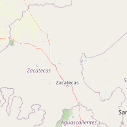
Map view of Cuenca Alimentadora del Distrito Nacional de Riego 01 Pabellón

Use this park location map to pinpoint Cuenca Alimentadora del Distrito Nacional de Riego 01 Pabellón in Mexico, understand its exact geographic position, and read its mapped placement within the surrounding landscape more clearly.

Pigeon | © OpenStreetMap contributors

Location context for Cuenca Alimentadora del Distrito Nacional de Riego 01 Pabellón

AguascalientesZacatecas
Park atlas

Compare adjacent protected areas and surrounding regional mountain landscapes

Other Parks Near Cuenca Alimentadora del Distrito Nacional de Riego 01 Pabellón

Browsing nearby national parks and connected protected areas helps place Cuenca Alimentadora del Distrito Nacional de Riego 01 Pabellón within the wider geography of the Sierra Madre Occidental. Comparing adjacent reserves reveals broader patterns in regional watershed conservation and highland terrain across central Mexico.
A soft watercolor painting of layered green and pink hills under a pale yellow sky.
Protected areaGuanajuato
About 141 km away#1 closest

Southeast

Sierra de Lobos Protected Area: Mountain Geography and Watershed Mapping in Guanajuato

An ecological transition zone between the Bajío and the Mexican Plateau

Sierra de Lobos stands as a complex mountain range and sustainable use area in Guanajuato, Mexico. Its unique physiographic location provides a habitat bridge for diverse wildlife and a necessary water source for regional communities. This profile maps its transition from tropical dry forest foothills to pine-oak forests at higher altitudes, highlighting its role as a core protected landscape.

Area
1,270.58 km²
Established
1997
Relief
Mountain
Climate
Subtropical
National parkMexico
About 161 km away#2 closest

East

El Gogorrón National Park: National Park Protected Landscape and Geography

Mapped boundaries and regional atlas context in Mexico

El Gogorrón National Park is a protected natural area designated as a National Park within Mexico. This entry provides essential details for understanding its geographic significance, mapped boundaries, and its role in the country's conservation landscape. Discover the park's contribution to regional geography and its structured representation within the MoriAtlas exploration platform.

Area
250 km²
Established
1936
IUCN
II
Relief
Mountain
A horizontal watercolor illustration depicting rolling green hills and distant muted mountain ranges.
Nature reserveJalisco
About 188 km away#3 closest

Southwest

Barranca de Oblatos: Protected Canyon Nature Reserve and Geographical Landmark in Jalisco

Urban-adjacent nature reserve and protected river corridor

Barranca de Oblatos is a striking geological feature and nature reserve that anchors the biodiversity of the Guadalajara metropolitan region. Featuring a deep canyon system carved by the Rio Grande de Santiago, this protected area holds a complex mosaic of tropical deciduous forests and historical landmarks within its dramatic vertical walls. Explore the landscape context and natural boundaries that define this essential western Mexican wilderness area.

Area
11.37 km²
Established
1997
Relief
Highland
Climate
Subtropical
A watercolor painting showing a panoramic view of rolling hills and a light forest in a park setting.
Protected areaZapopan
About 188 km away#4 closest

Southwest

Bosque el Nixticuil Protected Area: Mapping the Urban Forest Landscape in Zapopan

Volcanic terrain and watershed protection in Jalisco

Bosque el Nixticuil represents a key case of community-led urban conservation. Covering roughly 1,860 hectares in the municipality of Zapopan, this area protects a rare old-growth oak and pine ecosystem from metropolitan development. The park encompasses diverse topographic features including shallow canyons and plains, serving as a vital ecological anchor for the surrounding Río Blanco basin.

Area
18.6 km²
Established
2008
Visitors
3.2M annual
Relief
Mixed relief
A horizontal watercolor painting depicting a soft-focus landscape with rolling green hills, patches of forest, and light golden hues representing meadows or dry terrain.
Biosphere reserveJalisco
About 201 km away#5 closest

Southwest

La Primavera Biosphere Reserve: Mapping Volcanic Landscapes and Protected Watersheds

Ecological geography and forest distribution in Jalisco, Mexico

Centering on the Sierra la Primavera volcanic complex, this biosphere reserve functions as an essential green corridor and water catchment zone. The terrain consists of a complex mosaic of vegetation types, including pine-oak forests and relict cloud forest patches across high-elevation ridges. Discover the structural role of these protected lands in moderating the climate and supporting biodiversity in the Guadalajara metropolitan region.

Area
305 km²
Established
2000
IUCN
VI
Relief
Mountain
Protected areaMexico
About 204 km away#6 closest

West

Cuenca Alimentadora del Distrito Nacional de Riego 043 Estado de Nayarit: Atlas Overview

Watershed reserve and montane forest geography

This extensive protected area spans the Sierra Madre Occidental, featuring a fragmented landscape of high mountain ridges separated by river valleys. It safeguards critical pine and oak forest ecosystems that supply the Irrigation District 043, serving as a vital natural resource hub in west-central Mexico.

Area
23,290.3 km²
Established
1949
IUCN
VI
Relief
Mountain
National parkSombrerete Municipality
About 209 km away#7 closest

Northwest

Sierra de Órganos National Park National Park: Mapped Protected Landscape Details

Explore geographic context and park boundaries within Sombrerete Municipality.

Sierra de Órganos National Park stands as a vital national park, offering a unique opportunity for geographic and atlas-based discovery. This dedicated entry focuses on its protected landscape identity, providing detailed insights into its mapped boundaries and its place within the regional geography of Sombrerete Municipality. Understand the park's role as a protected natural area through structured data and landscape context, essential for comprehensive geographic exploration.

Area
11.25 km²
Established
2000
IUCN
II
Relief
Mountain
Watercolor painting of a wide, calm lake surrounded by low, rolling hills and lush green vegetation under a soft, hazy sky.
Wildlife reserveJalisco
About 219 km away#8 closest

South

Lake Chapala Wildlife Reserve: A Geographic Exploration of Mexico's Largest Freshwater Basin

Highland volcanic landscapes and protected wetland boundaries in Jalisco

Lake Chapala functions as the central hydrological anchor of the Lerma-Santiago watershed. Situated on a high volcanic plateau, this protected wildlife reserve spans a broad valley floor surrounded by dramatic sierras. Gain detailed perspective on its unique endemic fauna, including rare fish species and migratory waterbirds, while navigating the mapped geography of its shoreline, islands, and basin-wide ecological footprint.

Area
1,100 km²
Established
2009
Relief
Mixed relief
Climate
Temperate

Common questions about visiting, size, designation, and location context for Cuenca Alimentadora del Distrito Nacional de Riego 01 Pabellón

Cuenca Alimentadora del Distrito Nacional de Riego 01 Pabellón FAQs for park facts, access, geography, and protected area context

Find quick answers about Cuenca Alimentadora del Distrito Nacional de Riego 01 Pabellón, including protected-area facts, park geography, trail and visitor context, and how the park fits into its surrounding country and regional landscape.
MoriAtlas Explorer

Continue Your Protected Areas Search Across the Global Atlas

Deepen your exploration by continuing the structured search for national parks and protected areas worldwide. Utilize the comprehensive filtering capabilities to compare different conservation landscapes and refine your understanding of global park geography. Discover more about the distribution and characteristics of protected natural areas.

Global natural geography