
Mori Atlas logo
National parkCufada National Park

Discover the mapped boundaries and geographic context of this significant protected area.

Cufada National Park: Guinea-Bissau's Premier National Park and Protected Landscape

(Lagoas Cufada Natural Park)

Cufada National Park stands as a vital national park within Guinea-Bissau, offering a unique focus for understanding protected landscapes and regional geography. This page provides detailed geographic context, enabling exploration of the park's mapped boundaries and its place within the West African nation's natural terrain. Engage with the atlas-style data to appreciate the conservation significance and landscape character of Cufada National Park.

Coastal WetlandsLagoonsBirdwatchingWest AfricaProtected AreaGuinea-Bissau

Cufada National Park

National park

Park overview

Structured park overview, official facts, and landscape profile for Cufada National Park

Cufada National Park park facts, protected area profile, and essential visitor context

Review the core facts for Cufada National Park, including designation, size, terrain, visitor scale, habitats, and operating context in one park-focused overview.

About Cufada National Park

Cufada National Park protects a coastal wetland ecosystem in Guinea-Bissau, a country that spans much of the Upper West African Atlantic coast. The park's central feature is its lagoon system, which creates diverse aquatic and semi-aquatic habitats within a relatively flat coastal plain. These lagoon environments support specialized vegetation communities adapted to brackish water conditions and seasonal flooding patterns. The protected area contributes to Guinea-Bissau's commitment to preserving its natural heritage, which includes coastal marshes, tidal zones, and associated terrestrial fringes. The park's existence reflects recognition that wetland ecosystems provide critical services including water filtration, flood regulation, and habitat provision for numerous species.

Quick facts and research context for Cufada National Park

Cufada National Park is situated along Guinea-Bissau's Atlantic coastal zone. The protected area centers on a system of coastal lagoons and associated wetland habitats. It forms part of Guinea-Bissau's national park estate and provides ecological functions typical of West African coastal wetland systems. The park supports birdlife and serves as a refuge for water-associated species within the region's biodiversity landscape.

Protection and recognition

Verifying the legal conservation status and global environmental registry records for the park

Cufada National Park Protection Status and International Designation Records

Explorers can track the documented protection status, official designation history, and management frameworks associated with Cufada National Park. Reviewing verified environmental registry details provides essential geographic context for understanding regional conservation boundaries and governance.

Protection details

Transboundary protection
No
Park context

Deeper park guide and search-rich context for Cufada National Park

Cufada National Park history, landscape, wildlife, and travel context

Explore Cufada National Park through its history, landscape character, ecosystems, wildlife, conservation priorities, cultural context, and seasonal travel timing in a structured park guide built for atlas discovery and search intent.

Why Cufada National Park stands out

Cufada National Park is recognized for its coastal lagoon system and wetland habitats that provide sanctuary for waterfowl and migratory bird species. The park's lagoonal environment represents a distinctive feature within Guinea-Bissau's protected landscape, offering ecological value through its wetland ecosystems and associated biodiversity.

Cufada National Park history and protected-area timeline

Cufada National Park was established as part of Guinea-Bissau's protected area system. The park's creation reflected the country's post-independence efforts to identify and safeguard ecologically significant landscapes within its territory. Guinea-Bissau, having gained independence in 1974, developed a national parks and protected areas framework to conserve its natural resources and biodiversity. The designation of Cufada as a national park acknowledged the ecological value of its coastal lagoon system and the need to maintain this habitat for ongoing environmental and biodiversity purposes.

Cufada National Park landscape and geographic character

The park occupies a coastal setting characterized by low-lying terrain, lagoon systems, and extensive wetland areas. The landscape features shallow lagoons surrounded by marshy fringes, with vegetation adapted to periodic tidal influence and seasonal water level changes. The coastal plain on which the park sits is typical of West Africa's Atlantic seaboard, featuring gentle topography and proximity to the ocean. The lagoonal environment creates a mosaic of open water, reed beds, and muddy substrates that define the visual and ecological character of the protected area.

Cufada National Park ecosystems, habitats, and plant life

Cufada National Park encompasses coastal wetland habitats that support characteristic West African biodiversity. The lagoon system provides critical habitat for waterfowl, including both resident bird species and migratory populations that use the West African coast as a seasonal route. The wetland environment supports fish populations that обитают in shallow waters and serve as prey for bird predators. Vegetation in the park's lagoon fringes includes emergent aquatic plants and salt-tolerant species adapted to the brackish water conditions created by tidal mixing.

Cufada National Park wildlife and species highlights

The park's wetland habitats support bird populations that represent the most visible wildlife presence in the area. Waterfowl and wading birds utilize the lagoon environments for feeding and nesting. The aquatic environment contains fish species that thrive in the shallow, sheltered lagoon waters. The park's protected status creates a refuge where bird populations can maintain their presence within the broader coastal landscape of Guinea-Bissau.

Cufada National Park conservation status and protection priorities

Cufada National Park represents Guinea-Bissau's effort to preserve its coastal wetland ecosystems and the biodiversity they support. The protected area designation provides formal recognition of the lagoonal environment's ecological value and establishes a framework for ongoing conservation management. Wetland protection addresses broader environmental concerns including habitat preservation for migratory bird populations and maintenance of coastal ecosystem functions.

Cufada National Park cultural meaning and human context

The park exists within a region where local communities have traditional connections to coastal and lagoon environments. The coastal zone of Guinea-Bissau has historically supported fishing communities whose livelihoods depend on aquatic resources. The park's protected status exists alongside these ongoing human activities, balancing conservation objectives with traditional land use patterns.

Top sights and standout views in Cufada National Park

Cufada National Park offers access to Guinea-Bissau's coastal lagoon environment, providing opportunities to observe wetland birdlife in a protected setting. The park's lagoon system represents a distinctive coastal landscape within West Africa, characterized by shallow water bodies, emergent vegetation, and tidal influence. Visitors can experience the tranquility of a coastal wetland area that shelters diverse bird species and maintains ecological functions typical of Atlantic-side lagoon systems.

Best time to visit Cufada National Park

The optimal period for visiting Cufada National Park falls during the dry season when lower rainfall creates more accessible conditions and wildlife viewing opportunities improve. Birdwatching activities are most productive during migratory seasons when additional species are present in the lagoon habitats. The dry months offer clearer conditions for exploring the park's wetland environments.

Monthly climate preview

Track long term monthly averages and historical climate patterns across the protected landscape

Cufada National Park Climate Normals, Annual Temperature and Precipitation Rhythm

Representative coordinates record measured temperatures ranging from 24.27 degrees Celsius to 30.17 degrees Celsius alongside distinct monthly precipitation shifts from near zero to over sixteen millimeters per day. Examining the complete twelve month dataset provides deeper analytical context for long term climatic conditions across the protected area.
Annual mean27 °C
24 °C30 °C
Jan25°
Feb28°
Mar29°
Apr30°
May30°
Jun28°
Jul26°
Aug26°
Sep26°
Oct27°
Nov26°
Dec24°
Warmest month
April

30.2 °C

Coolest month
December

24.3 °C

Wettest month
August

16.7 mm/day

Driest month
February

0 mm/day

Park location guide

Geography guide, regional context, and park location map for Cufada National Park

Cufada National Park park geography, regions, and map view in Guinea-Bissau

Understand where Cufada National Park sits in Guinea-Bissau through a broader geographic reading of the surrounding landscape, nearby location context, and its mapped position within the national park landscape.

How Cufada National Park fits into Guinea-Bissau

Guinea-Bissau is a West African nation that gained independence from Portugal in 1974. The country covers 36,125 km² along the Atlantic coast, bordered by Senegal and Guinea. Its capital is Bissau. The nation is characterized by ethnic diversity, with Balanta and Fula being the largest groups, and Portuguese as its official language. Guinea-Bissau has experienced political instability since independence and remains one of the poorest countries globally.

Wider geography shaping Cufada National Park in Guinea-Bissau

Guinea-Bissau is located in West Africa along the Atlantic Ocean. It borders Senegal to the north and Guinea to the southeast. The country consists of low-lying coastal plains with inland hills and forests. The Geba River basin dominates the interior landscape.

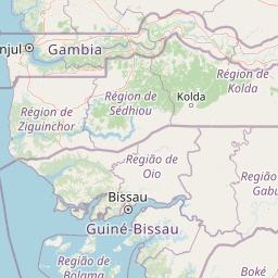
Map view of Cufada National Park

Use this park location map to pinpoint Cufada National Park in Guinea-Bissau, understand its exact geographic position, and read its mapped placement within the surrounding landscape more clearly.

Pigeon | © OpenStreetMap contributors

Location context for Cufada National Park

Cacheu Region
Park atlas

Compare protected areas across Guinea-Bissau and the wider West African coast, detailing their varied wetland and coastal geography.

Explore More National Parks and Protected Areas Near Cufada National Park

After exploring Cufada National Park, browse other national parks and protected areas located in Guinea-Bissau and the broader West African region. Compare their distinct coastal wetland systems, diverse lagoon environments, and unique conservation landscapes to trace the regional spread of protected geography and ecological features.
Protected areaGuinea-Bissau
Mapped park locations coincide#1 closest

Lagoas Cufada Natural Park: Explore Guinea-Bissau's Protected Area Geography and Mapped Landscape

Regional geographic context and protected landscape identity.

Lagoas Cufada Natural Park represents a key protected area within Guinea-Bissau, contributing to the nation's conservation landscape. This entry focuses on its geographic identity, providing users with mapped boundary information and an understanding of its place within the regional geography. It serves as a foundation for exploring the park's specific natural landscape characteristics and its atlas-based significance.

National parkGuinea-Bissau
About 50 km away#2 closest

South

Cantanhez Forests National Park: A Protected Landscape within Guinea-Bissau's Geography

Explore mapped boundaries and regional landscape context.

Cantanhez Forests National Park stands as a notable protected area, providing a specific lens through which to understand the natural geography of Guinea-Bissau. This entry facilitates an atlas-style examination of the park's identity, focusing on its landscape character and its position within the regional geographic framework of West Africa. Delve into the structured information to appreciate the unique protected-area context that Cantanhez Forests National Park contributes to the country's mapped natural heritage.

IUCN
II
Scope
Terrestrial
National parkGuinea-Bissau
About 103 km away#3 closest

West

Orango National Park: Protected Landscape and Geographic Atlas Explorer in Guinea-Bissau

Discover mapped park boundaries and regional natural terrain.

Delve into the protected-area identity of Orango National Park, a significant national park located in Guinea-Bissau. This page provides essential geographic context, mapping details, and landscape character for atlas-driven exploration. Understand how Orango National Park fits within the broader regional geography of West Africa, offering a focused view of protected lands for dedicated discovery.

Area
1,582 km²
Established
2000
IUCN
II
Relief
Lowland
Protected landscapeGuinea-Bissau
About 109 km away#4 closest

Northwest

Cacheu River Mangroves Natural Park: A Protected Landscape of Tidal Wetlands and Mangrove Forests

Explore Guinea-Bissau's largest contiguous mangrove ecosystem and its mapped geographic context.

This natural park protects a unique tidal landscape in Guinea-Bissau, dominated by one of West Africa's most substantial mangrove forests covering 68% of its 886 square kilometer area. The park's intricate network of waterways and mudflats, shaped by the Cacheu River's estuary meeting the Atlantic, offers crucial habitat and coastal protection. Its designation as a Ramsar site underscores its international importance as a wetland, providing a distinct focus for atlas-driven geographic discovery.

Area
886 km²
Established
2000
IUCN
II
Relief
Lowland
Marine protected areaBolama Region
About 112 km away#5 closest

Southwest

João Vieira and Poilão Marine National Park: Mapped Marine Protected Area in Bolama Region

Explore protected marine boundaries and regional geography.

João Vieira and Poilão Marine National Park is identified as a crucial marine protected area within the Bolama Region. This atlas-focused entry details its geographic scope and protected status, offering a clear view of its mapped landscape. It serves as a primary reference for understanding the park's specific marine environment and its place within the broader regional geography.

Area
495 km²
Established
2000
IUCN
II
Relief
Lowland
Nature reserveBoke Region
About 150 km away#6 closest

South

Rio Kapatchez Managed Nature Reserve: Coastal Estuarine Mapping and Protected Area Overview

Tidal wetland geography within the Boke region of Guinea

Examine the protected coastal landscapes of Rio Kapatchez Managed Nature Reserve, a significant wetland system where freshwater river flow merges with Atlantic tidal influences. This reserve provides an essential geographic look at mangrove-rich estuarine environments and the sediment-driven topography of the western Guinean coastline.

Area
200 km²
Established
1992
Relief
Lowland
Scope
Mixed
Protected areaGuinea
About 156 km away#7 closest

Southeast

Rio Pongo: A Protected Estuarine Wetland Landscape in Coastal Guinea

Mapping mangrove forests, tidal mudflats, and coastal ecology

Rio Pongo is a prominent protected area in Guinea, characterized by a complex network of brackish tidal channels and dense mangrove forests. The site serves as a crucial habitat for waterbirds and aquatic mammals, while its position at the edge of the Atlantic Ocean defines a dynamic, low-lying coastal terrain that remains vital for regional conservation and ecological research.

Area
300 km²
Established
1992
Water
Water-dominated
National parkZiguinchor Region
About 182 km away#8 closest

Northwest

Basse Casamance National Park: National Park with Mapped Boundaries in Ziguinchor Region

Detailed protected landscape and regional geography context.

Basse Casamance National Park serves as a critical protected area, offering users a clear view of its national park designation and its specific geographic location within Senegal. This entity is vital for understanding conservation landscapes and mapped terrain in the Ziguinchor Region. The platform provides structured data on its protected boundaries, allowing for focused atlas exploration and a deeper appreciation of its regional geographic significance without leaving the core park identity.

Area
50 km²
Established
1970
IUCN
II
Climate
Tropical

Common questions about visiting, size, designation, and location context for Cufada National Park

Cufada National Park FAQs for park facts, access, geography, and protected area context

Find quick answers about Cufada National Park, including protected-area facts, park geography, trail and visitor context, and how the park fits into its surrounding country and regional landscape.
MoriAtlas Explorer

Continue Your Protected Areas Search Across the Global Atlas

Deepen your exploration by continuing the structured search for national parks and protected areas worldwide. Utilize the comprehensive filtering capabilities to compare different conservation landscapes and refine your understanding of global park geography. Discover more about the distribution and characteristics of protected natural areas.

Global natural geography
