

Mori Atlas logo
Nature reserveCutta Cutta Caves Nature Park

A rare tropical karst reserve in Australia, preserving unique subterranean formations and woodland ecosystems.

Cutta Cutta Caves Nature Park: Exploring Tropical Limestone Karst and Protected Cave Landscapes

Cutta Cutta Caves Nature Park sits within the Northern Territory of Australia, representing a singular protected landscape where tropical woodland meets an extensive limestone karst system. This reserve safeguards subterranean passages and rare habitats, offering insight into the geological evolution of the Top End. Visitors to these protected lands find a distinct environment defined by cave chambers, mineral formations, and the biological diversity of an essential tropical refuge.

caveslimestone karstshow cavestropical woodlandNorthern TerritoryTop End Australia

Cutta Cutta Caves Nature Park

Nature reserve

Park overview

Structured park overview, official facts, and landscape profile for Cutta Cutta Caves Nature Park

Cutta Cutta Caves Nature Park park facts, protected area profile, and essential visitor context

Review the core facts for Cutta Cutta Caves Nature Park, including designation, size, terrain, visitor scale, habitats, and operating context in one park-focused overview.

About Cutta Cutta Caves Nature Park

Cutta Cutta Caves Nature Park is a focused reserve in the Katherine region of the Northern Territory, designed to protect a tropical limestone karst landscape and the underground cave systems it contains. Although small in area, the park draws attention because karst environments are uncommon in northern Australia, and tropical cave systems are even rarer. The reserve supports the main show cave, Cutta Cutta Cave, which extends hundreds of meters beneath the surface, as well as additional cave systems that remain closed to the public to protect both the formations and the sensitive wildlife within them.

The park sits within the broader tropical woodland and savanna landscape of the Top End, a setting defined by seasonal rainfall, warm temperatures year-round, and a transition between open woodland and denser riparian vegetation along drainage lines. Above ground, the karst geology influences soils and vegetation, while below ground, the caves host a specialized environment of constant darkness, high humidity, and stable temperatures. This sharp contrast between surface tropical conditions and stable subterranean climate gives the park a particularly interesting ecological profile.

The park is managed with a strong focus on visitor education and conservation. Interpretive walks and guided cave tours explain the formation of limestone caves, the role of water in shaping karst landscapes, and the unusual wildlife that depends on these systems. Visitor infrastructure is deliberately compact, including a visitor centre, kiosk, and walkways inside the cave itself. This approach helps concentrate human impact in a small, controlled area while protecting the wider reserve from unnecessary disturbance.

Culturally, the park carries significance for the Jawoyn people, who associate the caves with dreaming narratives that link the site to the broader spiritual and ecological landscape of the region. The park's protected status is intended to honor and safeguard this cultural significance alongside its natural values. As a result, Cutta Cutta Caves Nature Park serves simultaneously as a geological showcase, a wildlife refuge, and a place of cultural meaning, all within a relatively small but carefully managed reserve close to Katherine.

Quick facts and research context for Cutta Cutta Caves Nature Park

Cutta Cutta Caves Nature Park is a small IUCN Category III protected area, designated for a natural monument or feature, in the Northern Territory of Australia. It lies near Katherine, accessible from the Stuart Highway. The park was placed under formal reserve management in 1967 and later renamed Cutta Cutta Caves Nature Park in 1979. It is managed by the Parks and Wildlife Commission of the Northern Territory and includes a visitor centre, guided cave tours, and a Tropical Woodland walk.

Protection and recognition

Documented terrestrial protection scope and 1979 designation records

Cutta Cutta Caves Nature Park Protection Status and Designation History

Cutta Cutta Caves Nature Park maintains a documented terrestrial protection status established in 1979. Comprehensive conservation records outline the official designation history and management scope associated with the protected landscape.

Protection details

Protection scope
Terrestrial
Designated year
1979
Transboundary protection
No
Park context

Deeper park guide and search-rich context for Cutta Cutta Caves Nature Park

Cutta Cutta Caves Nature Park history, landscape, wildlife, and travel context

Explore Cutta Cutta Caves Nature Park through its history, landscape character, ecosystems, wildlife, conservation priorities, cultural context, and seasonal travel timing in a structured park guide built for atlas discovery and search intent.

Why Cutta Cutta Caves Nature Park stands out

Cutta Cutta is best known as the only tropical show cave system in Australia that is regularly accessible to the public through guided tours. The park is also well known for its dramatic limestone karst formations, including stalactites and stalagmites that formed in a tropical setting unusual within Australia. A further point of distinction is its role as habitat for rare cave-dependent wildlife, particularly the ghost bat, which adds ecological importance to a site already valued for its geology.
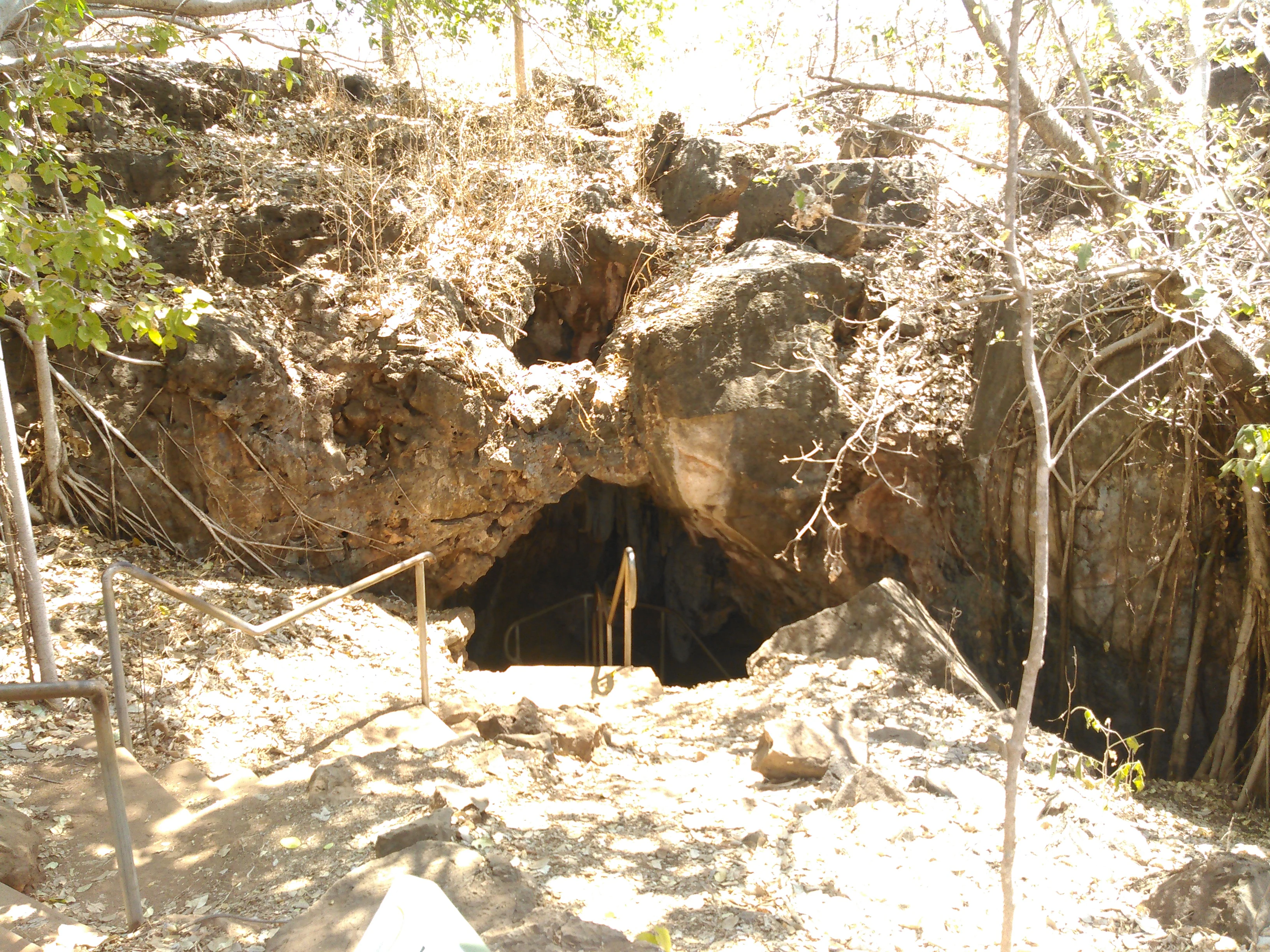
A natural cave entrance framed by rocky limestone formations and dry vegetation, with a metal railing and stairway leading down into the darkness.
The entrance to the Cutta Cutta Caves in Northern Territory, Australia.

Cutta Cutta Caves Nature Park history and protected-area timeline

The caves that give the park its name were first documented by Europeans around 1900, when a stockman discovered the main cave in what was then a remote part of the Northern Territory. Over subsequent decades, the main chamber became known informally by a series of names reflecting the changing context of the region. It was initially called Smith's Cave after early visitors, and later, during the Second World War, servicemen in the area referred to it as 16 Mile Cave because of its distance marker position along local roads.

The site entered formal protection in April 1967, when the reserve, then known as Sixteen Mile Caves Reserve, was placed under the management of the Northern Territory Reserves Board. Guided tours began shortly after, marking the start of the caves' long role as a public attraction. In 1979 the reserve was renamed Cutta Cutta Caves Nature Park, adopting a name drawn from Jawoyn language and signaling an effort to align the park more closely with its cultural and regional identity. A second cave, Tindal Cave, was opened to the public in 1991, broadening the visitor experience, although it has since been closed to protect the cave environment, leaving a single cave open for guided tours.

For the Jawoyn people, the park's history is far longer than the European story of discovery and reservation. The caves are linked to dreaming narratives, and the broader park landscape holds evidence of traditional occupation, including campsites and stone artifacts. These cultural layers are now part of how the park is interpreted and protected alongside its geological and ecological values.

Cutta Cutta Caves Nature Park landscape and geographic character

The defining landscape feature of Cutta Cutta Caves Nature Park is its limestone karst terrain, a relatively uncommon landform in tropical northern Australia. Above ground, the karst expresses itself as gentle surface features shaped by the slow dissolution of limestone bedrock over long periods, while below ground it has produced an extensive network of caves, chambers, and passages. The main public cave extends about 750 meters in total, with around 240 meters lit and fitted with walkways for visitors, giving a strong sense of how the karst continues beyond the accessible section. Stalactites hang from cave ceilings, stalagmites rise from the floors, and other speleothem formations record the patient work of mineral-rich water over geological time.

Beyond the caves themselves, the surrounding park landscape is shaped by the Top End's tropical climate. Vegetation is a mix of tropical woodland and seasonal open forest typical of the Katherine region, with the surface shaped by annual wet season rains that feed into groundwater systems, which in turn slowly continue to modify the caves below. During the wet season, the caves can flood, and access is sometimes restricted for safety and conservation reasons. This seasonal dynamism above ground contrasts with the stable conditions underground, where temperature and humidity remain relatively constant regardless of season.

The park's small footprint, only around 259 hectares according to protected-area records, belies the visual diversity of a landscape where tropical woodland, karst outcrops, and a hidden cave system combine within a single reserve.

Cutta Cutta Caves Nature Park ecosystems, habitats, and plant life

Cutta Cutta Caves Nature Park protects a surprisingly concentrated example of tropical karst ecology in the Northern Territory. The surface environment is dominated by tropical woodland adapted to the strongly seasonal climate of the Top End, where distinct wet and dry periods drive plant growth, flowering cycles, and animal activity. The park's Tropical Woodland walk introduces visitors to this above-ground ecosystem, which includes tree species, ground vegetation, and associated fauna typical of the Katherine region.

Below ground, the caves host a very different ecological community. The constant darkness, stable temperature, and high humidity create an environment suited to species specially adapted to cave life. Bats are an especially important part of this community. The ghost bat, a large carnivorous species of conservation significance, uses caves and similar sheltered environments as day roosts, making protected cave systems like those at Cutta Cutta a critical habitat type for the species. The presence of such a sensitive predator adds a strong conservation dimension to what might otherwise be seen primarily as a geological attraction.

Because caves are fragile environments and access is tightly managed, the park functions as both a visitor site and a refuge for cave-dependent wildlife. Limiting disturbance to a small portion of the system, through a single guided cave and closed-off additional caves, helps maintain the conditions that less tolerant species require.

Cutta Cutta Caves Nature Park wildlife and species highlights

Wildlife at Cutta Cutta Caves Nature Park is split between the tropical woodland environment on the surface and the cave habitats below. Above ground, visitors can encounter the typical fauna of the Katherine region, including reptiles, birds, and insects associated with tropical woodland and seasonal savanna habitats. Snakes are among the more commonly noted residents, with the brown tree snake sometimes observed in and around the cave systems and surrounding vegetation.

Underground wildlife is a particular point of interest. Caves provide critical roosting habitat for bats, and the rare ghost bat is among the most notable species recorded in the park. Ghost bats are significant both because of their conservation status and because of their ecological role as predators within cave and woodland systems. Their dependence on suitable cave environments makes reserves like Cutta Cutta important for the broader survival of the species across northern Australia.

Other cave-adapted invertebrates and small animals likely contribute to the underground food web, although they are less visible to casual visitors. Together, the surface woodland wildlife and the cave-roosting fauna give the park an ecological profile that is unusually layered for such a small protected area.

Cutta Cutta Caves Nature Park conservation status and protection priorities

Cutta Cutta Caves Nature Park has clear conservation value because it protects a rare combination of tropical karst geology and the cave-dependent wildlife that depends on it. The ghost bat, in particular, makes the park more than just a scenic site; the species relies on undisturbed cave systems for day roosting and breeding, and sites where such caves are actively protected play an important role in maintaining viable populations across northern Australia.

The park's IUCN Category III designation, recognizing it as a natural monument or feature, reflects the focus on protecting a specific geological phenomenon of natural significance. This status supports both habitat preservation and active management of visitor access. Caves are especially vulnerable to disturbance; vibrations, humidity changes, and human introduction of foreign materials can damage formations and disrupt wildlife, which is why many caves in the park remain closed to the public. Limiting access to a single, carefully managed cave reduces cumulative impact on the wider system.

Management of the flooding risk during the wet season is also part of the conservation picture. Seasonal closure of cave tours during high water periods protects both visitor safety and the cave environment from disturbance during a particularly dynamic time of year. In these ways, the park balances its role as a public attraction with the steady, long-term protection of a sensitive and valuable natural system.

Cutta Cutta Caves Nature Park cultural meaning and human context

Cutta Cutta Caves Nature Park holds deep cultural significance for the Jawoyn people, the traditional owners of the Katherine region. The caves are associated with Barrac Barrac, also known as Diver Duck dreaming, a set of creation narratives that link the site to broader spiritual and ecological patterns in Jawoyn culture. Some interpretations describe Cutta Cutta as a Jawoyn word meaning many stars, with caves understood as places where stars rest during the day, although specific names for individual formations within the documented and oral record are less clearly defined.

Archaeological evidence of Jawoyn presence can be found throughout the park, including campsites and stone artifacts, and at least one unnamed cave shows man-made grooves on an interior wall some distance from the entrance. There is a strong indication that while the Jawoyn people had a deep relationship with the landscape and the broader cave environment, they did not regularly enter deep cave systems, an interpretation that has helped guide modern management decisions about access.

This living cultural context sits alongside the European history of the caves, from their discovery by a stockman around 1900 to their eventual incorporation into the Northern Territory's formal reserve system in 1967. Today, the park's identity is shaped by this layered story: a site of Jawoyn dreaming narratives, an early point of European exploration and naming, and a modern protected area where cultural and natural heritage are managed together.

Top sights and standout views in Cutta Cutta Caves Nature Park

Cutta Cutta Caves Nature Park is defined by the unusual pairing of tropical climate and classic limestone karst. The accessible portions of the main cave give visitors a close-up view of stalactites, stalagmites, and other speleothem formations within a tropical setting that contrasts vividly with the typical European or temperate cave experience. The presence of the ghost bat and the brown tree snake adds unexpected ecological depth, reminding visitors that the caves are not only geological curiosities but also functioning wildlife habitat.

Best time to visit Cutta Cutta Caves Nature Park

The most comfortable period to visit Cutta Cutta Caves Nature Park generally falls during the dry season, when the Top End climate is less humid, road and park conditions are more reliable, and the risk of cave flooding is low. During the wet season, heavy rains can cause the caves to flood, leading to temporary closures that affect both safety and the visitor experience. Wildlife observation, including bat activity around dusk, can be rewarding at a range of times, but the cooler and drier months typically offer the most stable conditions for outdoor walking as well as underground touring.
Monthly climate preview

Long-term representative point measurements of annual temperature and precipitation rhythm

Cutta Cutta Caves Nature Park Climate Normals and Monthly Weather Records

Representative coordinate records show average temperatures ranging across twelve months alongside distinct monthly precipitation variations at Cutta Cutta Caves Nature Park. Examining the complete climate profile provides detailed historical baseline data for temperature and precipitation patterns.
Annual mean27 °C
22 °C31 °C
Jan28°
Feb27°
Mar27°
Apr26°
May24°
Jun22°
Jul23°
Aug24°
Sep29°
Oct31°
Nov31°
Dec30°
Warmest month
November

31.5 °C

Coolest month
June

22.4 °C

Wettest month
February

8.5 mm/day

Driest month
July

0 mm/day

Park location guide

Geography guide, regional context, and park location map for Cutta Cutta Caves Nature Park

Cutta Cutta Caves Nature Park park geography, regions, and map view in Australia

Understand where Cutta Cutta Caves Nature Park sits in Australia through a broader geographic reading of the surrounding landscape, nearby location context, and its mapped position within the national park landscape.

How Cutta Cutta Caves Nature Park fits into Australia

Australia is a constitutional monarchy and federal parliamentary democracy comprising six states and ten territories. With a population of nearly 28 million, it is one of the world's most urbanised countries, with most people concentrated on the eastern seaboard. The country has a high Human Development Index and is known for its cultural diversity, ancient Aboriginal heritage, and unique wildlife.

Wider geography shaping Cutta Cutta Caves Nature Park in Australia

Australia occupies the entire Australian continent, the island of Tasmania, and numerous smaller islands. It is the world's flattest and driest inhabited continent, featuring vast deserts in the interior (the Outback), tropical rainforests along the eastern coast, and a coastline bordering the Indian and Pacific Oceans.

Map view of Cutta Cutta Caves Nature Park

Use this park location map to pinpoint Cutta Cutta Caves Nature Park in Australia, understand its exact geographic position, and read its mapped placement within the surrounding landscape more clearly.

Pigeon | © OpenStreetMap contributors

Location context for Cutta Cutta Caves Nature Park

Northern Territory

Visualizing the tropical limestone karst terrain, cave formations, and surrounding woodland habitats.

Cutta Cutta Caves Nature Park Landscape and Scenery Photography

Visual documentation reveals the distinctive limestone karst terrain and tropical woodland habitats defining Cutta Cutta Caves Nature Park. Photographic records capture underground speleothems and surface environments that illustrate the unique character of this protected reserve.

A natural cave entrance framed by rocky limestone formations and dry vegetation, with a metal railing and stairway leading down into the darkness.

Park atlas

Discover neighboring limestone karst formations and regional Top End reserves

Explore Protected Areas and Parks Near Cutta Cutta Caves Nature Park

Browsing other protected areas near Cutta Cutta Caves Nature Park reveals wider patterns in northern Australian terrain and tropical woodland reserves. Comparing adjacent conservation landscapes provides valuable geographic context for understanding regional geological features and wildlife habitats.
National parkNorthern Territory
About 16 km away#1 closest

North

Nitmiluk National Park: Detailed Protected Landscape and Geographic Context

Explore mapped park boundaries and regional terrain.

Delve into the specifics of Nitmiluk National Park, a designated national park within the Northern Territory of Australia. This section focuses on its protected-area status and how its geography contributes to the regional landscape. Users can explore the park's mapped extent and understand its placement within the broader geographical atlas, highlighting its importance as a distinct protected natural area.

Area
2,946.64 km²
Established
1977
IUCN
II
Visitors
309.8K annual
Protected landscapeNorthern Territory
About 38 km away#2 closest

Northwest

Kintore Caves Conservation Reserve: Karst Geography and Protected Landscape Analysis

Mapping subterranean terrain and cultural heritage in Australia's Northern Territory.

Kintore Caves Conservation Reserve in the Northern Territory is a vital protected area defined by its rare limestone karst geology and extensive cave networks. This site provides a concentrated look at subterranean biodiversity and archaeological history within a transitional rural setting near Katherine, showcasing the importance of focused conservation boundaries in safeguarding geological and human-linked landscapes.

Area
4.23 km²
Established
1965
IUCN
V
Access
Access unknown
National parkAustralia
About 68 km away#3 closest

North

Kakadu National Park: Australia's Protected Landscape and Regional Geography

Explore Kakadu National Park's mapped boundaries and natural terrain.

Kakadu National Park stands as a significant national park entity within Australia, providing rich geographic context for atlas discovery. This page details the park's protected area identity, its mapped natural landscapes, and its place within the broader Australian continent's geography. Understand the unique regional setting and the specific topographic features that define Kakadu National Park for detailed exploration and comparative geographic analysis.

Area
19,804 km²
Established
1979
IUCN
II
Visitors
250K annual
National parkNorthern Territory
About 76 km away#4 closest

Southeast

Elsey National Park: Northern Territory National Park Atlas and Protected Landscape Context

Discover the mapped terrain and unique natural features of Elsey National Park.

Elsey National Park, located in Australia's Northern Territory, is a significant protected area known for its distinctive thermal springs and characteristic paperbark woodlands. This national park provides a valuable point of study for understanding regional geography, mapped natural landscapes, and the hydrological importance of its riverine environments, offering a concrete example of protected land within the tropical savanna biome.

Area
138.96 km²
Established
1991
IUCN
II
Visitors
207.7K annual
Nature reserveNorthern Territory
About 94 km away#5 closest

West

Giwining / Flora River Nature Park: Protected Limestone Landscapes of Northern Territory

Geological spring systems and tropical riverine corridors.

The landscape of Giwining / Flora River Nature Park is defined by a network of calcium-rich springs emerging from Tindall Limestone. These waters have sculpted tufa dams and cascading waterfalls along the Flora River, creating a unique geological environment within the savanna woodlands of the Northern Territory.

Area
78.24 km²
Established
1993
IUCN
V
Relief
Lowland
Watercolor illustration showing rolling green hills, a red rock formation, and scattered trees
National parkNorthern Territory
About 155 km away#6 closest

Southwest

Judbarra National Park: Northern Territory National Park Protected Landscape and Geography

Discover its mapped terrain and ancient Indigenous rock art.

Judbarra National Park is a major national park in Australia's Northern Territory, recognized for its extensive Indigenous rock art, which constitutes a significant artistic province. Spanning a vast area with two distinct geographic sections, the park showcases a transition between tropical and semi-arid ecosystems. Users can explore its rugged terrain, sandstone escarpments, and mapped park boundaries to understand its unique regional geographic context and rich cultural heritage.

Area
13,004.1 km²
Established
1990
IUCN
II
Relief
Mixed relief
National parkNorthern Territory
About 161 km away#7 closest

North

Mary River National Park: National Park in Northern Territory, Australia

Mapped protected landscape and regional geographic context.

Mary River National Park is an officially designated national park located in the vast Northern Territory of Australia. This protected area offers rich opportunities for geographic discovery, allowing users to explore its mapped boundaries and understand its significance within the regional landscape. Discover the natural context and atlas positioning of Mary River National Park, contributing to a broader understanding of protected lands in Northern Australia.

Area
1,215.25 km²
Established
1966
IUCN
II
Visitors
336.4K annual
National parkNorthern Territory
About 177 km away#8 closest

West

Fish River Station National Park: Protected Landscapes and Geographic Atlas

Indigenous-managed conservation in the Northern Territory

Fish River Station serves as a critical conservation block south of Darwin, featuring a distinctive blend of riverine floodplains, billabongs, and rugged upland ranges. Its protected boundaries preserve a wide array of tropical habitats, highlighting the intersection of traditional land management and large-scale environmental preservation within the Australian National Reserve System.

Area
1,781 km²
Established
2010
IUCN
II
Relief
Mixed relief

Common questions about visiting, size, designation, and location context for Cutta Cutta Caves Nature Park

Cutta Cutta Caves Nature Park FAQs for park facts, access, geography, and protected area context

Find quick answers about Cutta Cutta Caves Nature Park, including protected-area facts, park geography, trail and visitor context, and how the park fits into its surrounding country and regional landscape.
MoriAtlas Explorer

Continue Your Protected Areas Search Across the Global Atlas

Deepen your exploration by continuing the structured search for national parks and protected areas worldwide. Utilize the comprehensive filtering capabilities to compare different conservation landscapes and refine your understanding of global park geography. Discover more about the distribution and characteristics of protected natural areas.

Global natural geography