
Mori Atlas logo
State or regional parkDiana Lake Provincial Park

Examining the intersection of temperate rainforest, freshwater ecosystems, and protected wetland terrain

Diana Lake Provincial Park: A Comprehensive Geographic Profile of North Coast British Columbia Landscapes

Diana Lake Provincial Park serves as a crucial protected landscape in British Columbia, characterized by its dense coastal temperate rainforest and productive freshwater environments. The park integrates diverse ecological zones, from the shoreline of Diana Lake and the riparian pathways of Diana Creek to the elevated trails ascending toward MacDonald Peak. This compact area offers a window into the complex interplay between Pacific Northwest forest structures, blanket bog formations, and essential salmonid habitats located along the regional Highway 16 corridor.

coastal temperate rainforestfreshwater lakesalmon habitatblanket bogsNorth Coast British Columbiaprovincial park
A digital illustration featuring a serene mountain landscape with a central waterfall flowing into a reflective lake, surrounded by pine trees and distant peaks in soft, muted tones.

Diana Lake Provincial Park

State or regional park

Park overview

Structured park overview, official facts, and landscape profile for Diana Lake Provincial Park

Diana Lake Provincial Park park facts, protected area profile, and essential visitor context

Review the core facts for Diana Lake Provincial Park, including designation, size, terrain, visitor scale, habitats, and operating context in one park-focused overview.

About Diana Lake Provincial Park

Diana Lake Provincial Park sits on the North Coast of British Columbia, just east of Prince Rupert, and forms part of the Highway 16 landscape corridor that links the coast to the Interior of the province. Despite its modest 233-hectare size, the park captures a vivid cross-section of the region's natural character, layering freshwater lake, riparian creeks, coastal temperate rainforest, and open blanket bogs into a single accessible protected area.

Lake waters are the defining physical element of the park. Diana Lake serves as the focal point for recreation and is the main freshwater feature for the surrounding region. Diana Creek flows through the property, and its nature trail is one of the park's signature experiences, leading visitors through old coastal rainforest where conifers, mosses, and ferns create the dense, moisture-laden atmosphere typical of Canada's Pacific coastline. The park's trail network does not stop at the lake: the MacDonald Trail begins here and steps across several blanket bogs before climbing toward MacDonald Peak, giving visitors a sense of progression from wetland to upland habitats.

Beyond recreation, the park carries important ecological weight. The lake and its tributaries host an unusually complete suite of salmonids, including all five species of Pacific salmon, plus steelhead, rainbow trout, and Dolly Varden trout, which signals both healthy connectivity and good water quality. The surrounding blanket bogs and coastal rainforest further contribute to biodiversity, moisture regulation, and carbon storage, while offering habitat for the region's birdlife and small mammals.

The park was established in 1980 under the management of BC Parks and operates primarily as a seasonal day-use area, typically accessible from mid-May through mid-September. Its position close to Prince Rupert, combined with its ecological richness and scenic qualities, makes Diana Lake Provincial Park a representative example of North Coast conservation: a small park that, through its diversity of habitats and waters, captures much of what defines the region's natural identity.

Quick facts and research context for Diana Lake Provincial Park

Diana Lake Provincial Park is a 233-hectare protected area in British Columbia's North Coast region, located about 16 km east of Prince Rupert along the Highway 16 corridor. Established on 4 March 1980 and administered by BC Parks, the park protects a freshwater lake system and surrounding coastal landscapes.

Its principal features are Diana Lake, Diana Creek, coastal temperate rainforest, and blanket bog communities. The area is recognized as the primary freshwater recreation site in the Prince Rupert region and supports a diverse assemblage of salmonid fish species, including all five Pacific salmon, steelhead, rainbow trout, and Dolly Varden trout.

Protection and recognition

Examine the documented terrestrial protection scope and regional designation records

Diana Lake Provincial Park Protection Status and Conservation Records

Diana Lake Provincial Park maintains a documented terrestrial protection scope within its regional landscape boundary. Official conservation records outline the established protected area classification and management framework for the terrain.

Protection details

Protection scope
Terrestrial
Transboundary protection
No
Park context

Deeper park guide and search-rich context for Diana Lake Provincial Park

Diana Lake Provincial Park history, landscape, wildlife, and travel context

Explore Diana Lake Provincial Park through its history, landscape character, ecosystems, wildlife, conservation priorities, cultural context, and seasonal travel timing in a structured park guide built for atlas discovery and search intent.

Why Diana Lake Provincial Park stands out

Diana Lake Provincial Park is known for combining coastal temperate rainforest, a productive freshwater lake, and intact bog ecosystems within a small, easily accessible footprint. The park's Diana Creek nature trail passes through classic Pacific Northwest rainforest, while the broader network of creeks and the lake itself sustain a remarkably complete suite of Pacific salmon species along with steelhead and trout. The park is also recognized for its blanket bogs, which are characteristic of the North Coast's wet maritime climate. Together with the surrounding forested ridges and the trail leading toward MacDonald Peak, these wetland and aquatic habitats give the park an unusually varied landscape profile for its size, anchored by its function as the principal freshwater recreation destination near Prince Rupert.
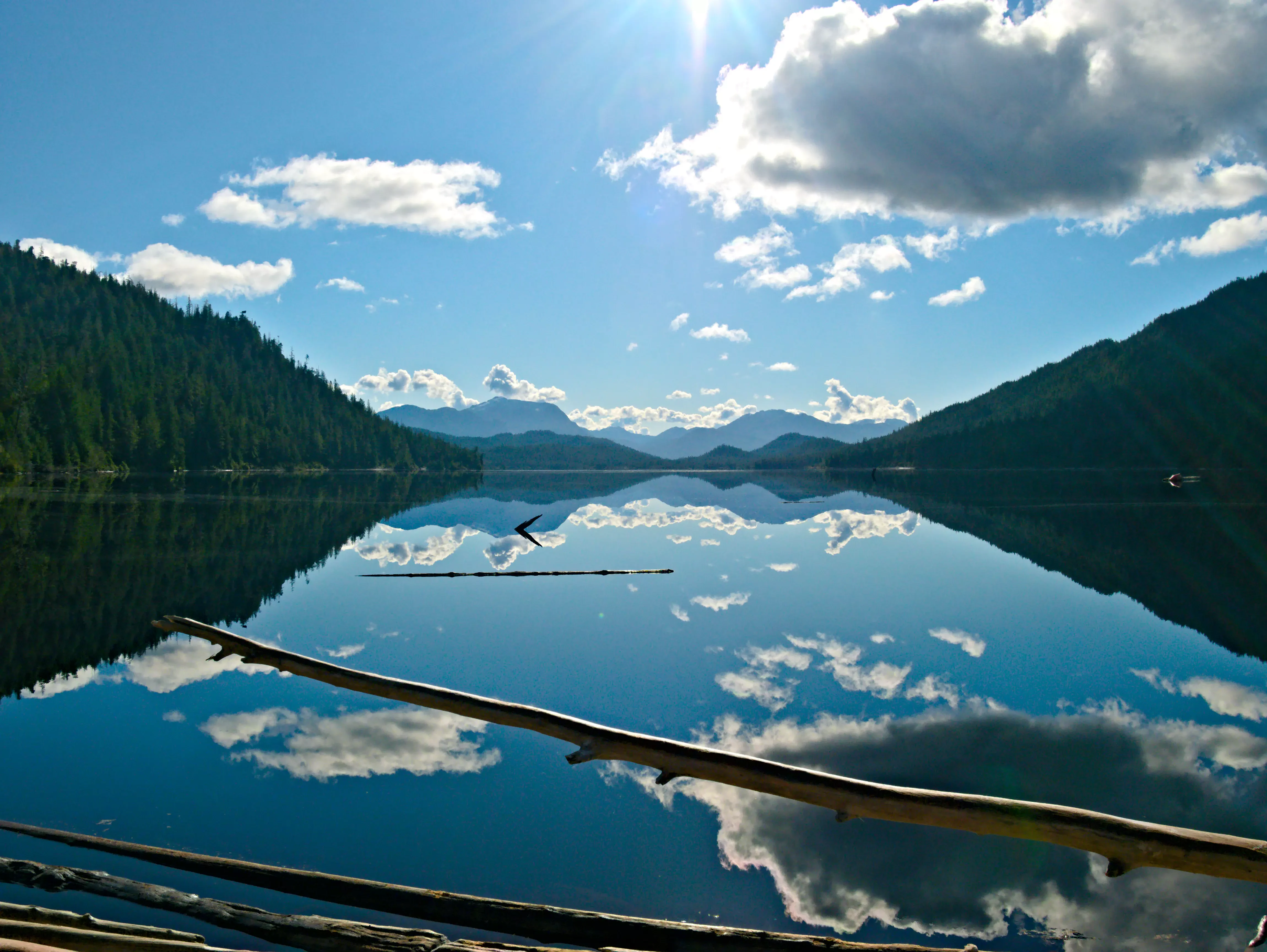
A wide, scenic view of a calm, reflective lake surrounded by dark evergreen forest and mountains in the distance, with a fallen tree branch in the foreground.
The calm waters of Diana Lake reflecting the surrounding mountains and clouds.

Diana Lake Provincial Park history and protected-area timeline

Diana Lake Provincial Park was established on 4 March 1980 by BC Parks as a protected area in the North Coast Regional District of British Columbia. Its creation reflected recognition of the area's value as both a recreational freshwater site for nearby Prince Rupert and a representative example of coastal temperate rainforest and bog ecosystems in the region.

Since its establishment, the park has remained a comparatively small but ecologically meaningful component of British Columbia's provincial park system. It has served as a local and regional outdoor destination, anchored on Diana Lake and the surrounding trails, rather than undergoing major boundary changes or redesignation. The park continues to be administered by BC Parks and remains part of the network of protected natural areas along the Highway 16 corridor.

Diana Lake Provincial Park landscape and geographic character

The landscape of Diana Lake Provincial Park is defined by the interplay of water, forest, and wetland typical of British Columbia's North Coast. Diana Lake forms the central feature, a freshwater body that gives the park its name and provides the visual and ecological anchor for the surrounding terrain. The lake is fed by and connected to Diana Creek, whose path through the park has shaped both the riparian soils and the experience of walking through the property.

Surrounding the lake and creeks is a matrix of coastal temperate rainforest, where coniferous canopy, mossy understory, and fern-rich ground create the dense, shaded atmosphere characteristic of the Pacific Northwest coast. This forest is interspersed with open blanket bogs, low, spongy wetland surfaces formed under the region's heavy rainfall, adding a distinctly different texture to the terrain.

The park's topography rises beyond the lake and bogs toward higher ground along the route to MacDonald Peak. The MacDonald Trail traces this vertical shift, allowing visitors to move from wetland and lakeshore up into forested slopes. A skid trail and small dam associated with historical resource activity, along with driftwood features along the shoreline, hint at the broader human and natural forces that have shaped this North Coast landscape.
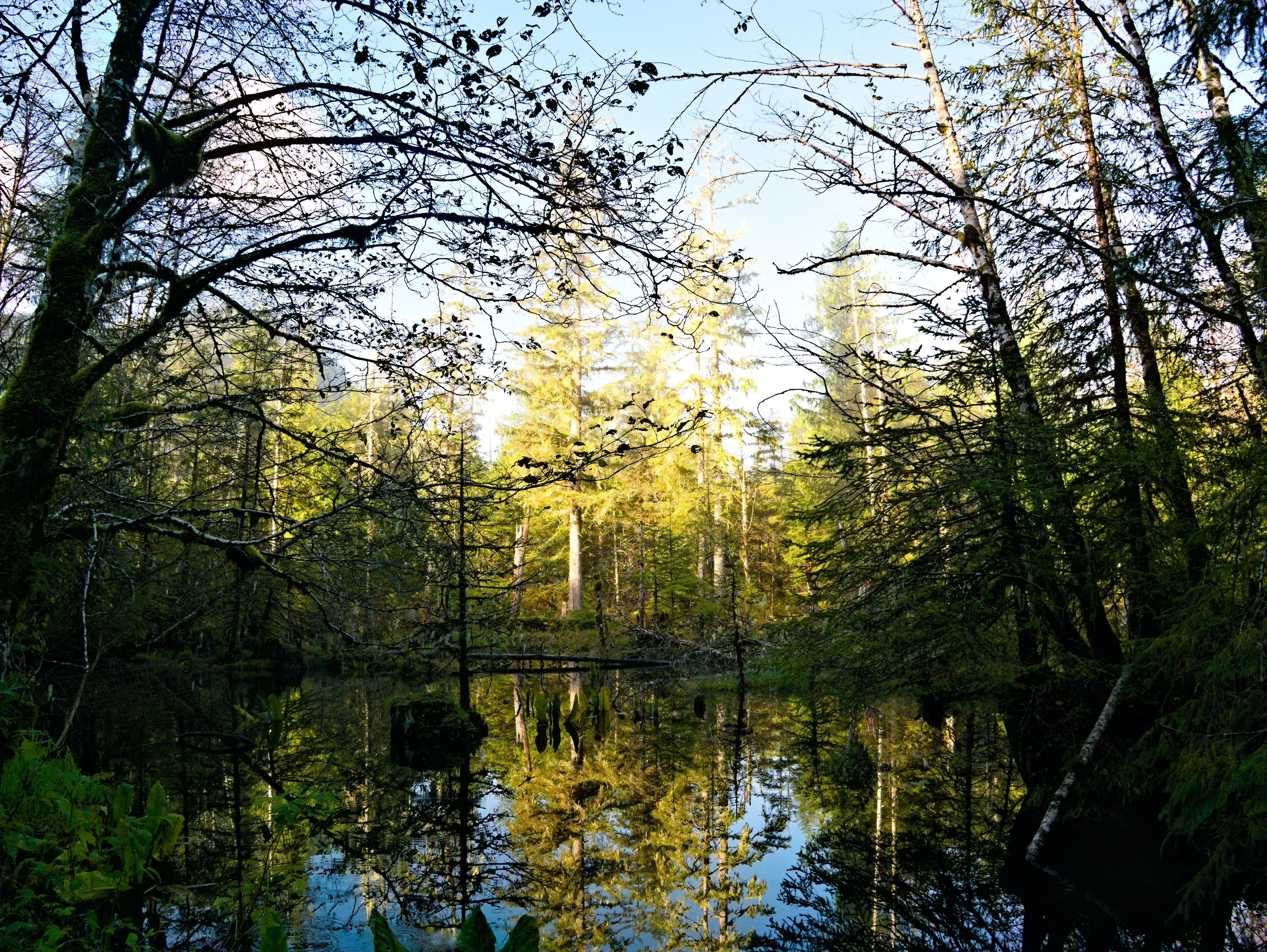
A calm, reflective wetland pool surrounded by a dense temperate forest with tall trees and dappled sunlight filtering through the canopy.
A tranquil wetland area framed by temperate forest within Diana Lake Provincial Park.

Diana Lake Provincial Park ecosystems, habitats, and plant life

Ecologically, Diana Lake Provincial Park belongs firmly within British Columbia's coastal temperate rainforest biome, one of the most moisture-rich and biologically productive forest systems in North America. The park's forests reflect this character, dominated by conifers and an understory of mosses, lichens, and ferns that thrive under persistent rainfall and mild coastal temperatures.

Wetlands form the second pillar of the park's ecology. Blanket bogs, a specialized peatland type that forms a continuous blanket over undulating terrain, cover portions of the property and are among the more distinctive ecological features of the North Coast. These bogs are valuable for water storage, carbon accumulation, and as habitat for specialized plant communities, and they sit in striking contrast to the taller, denser forest surrounding them.

The freshwater systems, including Diana Lake and its tributary creeks, complete the ecological picture. The lake and creeks support cold, well-oxygenated water conditions that allow a full suite of salmonid fish to complete their life cycles, linking the park's terrestrial and aquatic habitats into a single functioning ecosystem. This combination of rainforest, bog, and clean cold water habitats gives the small park an ecological profile that punches well above its size.
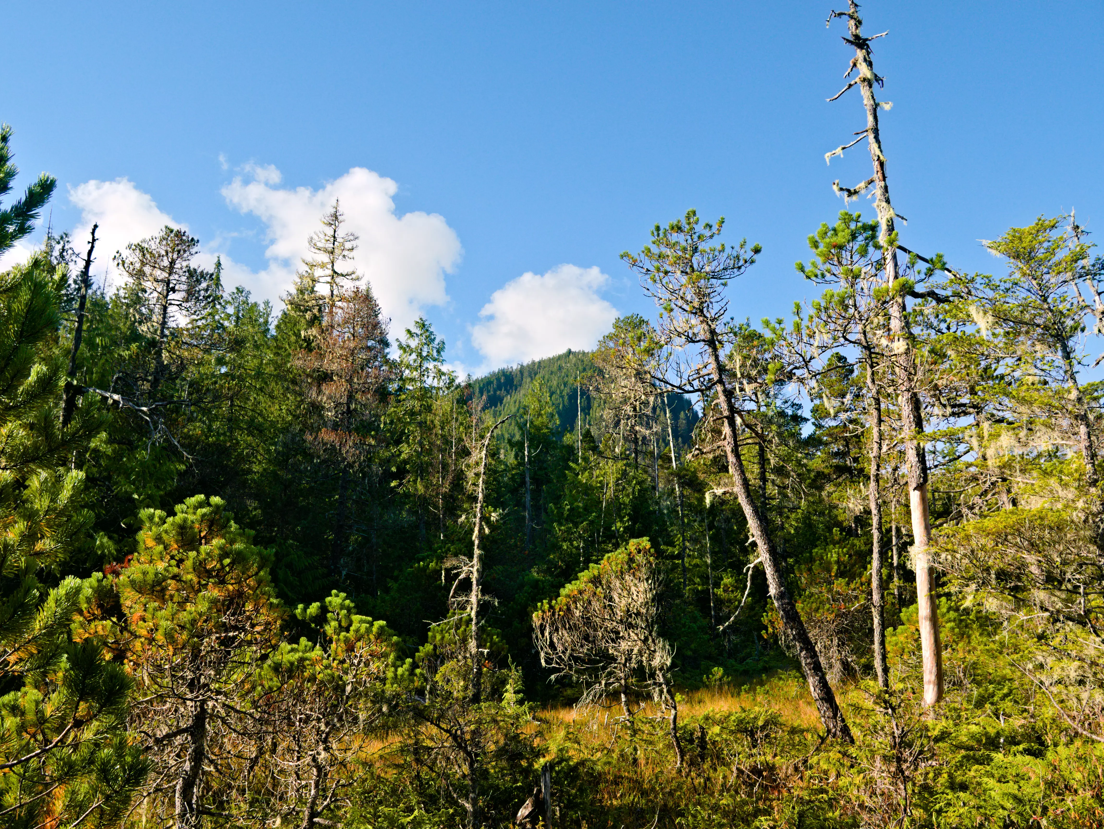
A dense forest landscape with a mix of evergreen trees and standing dead trees against a clear blue sky, featuring a boggy ground surface in the foreground.
A view of the bog woodland and conifer forest landscape in Diana Lake Provincial Park.

Diana Lake Provincial Park wildlife and species highlights

Wildlife values at Diana Lake Provincial Park are closely tied to its freshwater systems, its coastal rainforest, and its blanket bogs. The lake and creeks form the most prominent wildlife story, supporting all five species of Pacific salmon, an uncommon level of diversity that reflects the integrity of stream habitats and their connectivity to larger watershed systems. These include Chinook, coho, chum, pink, and sockeye salmon, alongside steelhead, rainbow trout, and Dolly Varden trout.

The surrounding coastal temperate rainforest provides habitat typical of the North Coast, where old-growth conifers and dense understory create shelter and forage for a range of mammals and birds. Species associated with this habitat type, including deer, small carnivores, and a variety of songbirds and forest raptors, are characteristic of the broader region and rely on the structural complexity of these forests.

Blanket bogs add a quieter but ecologically important wildlife dimension. These open, wet habitats host distinct plant communities and provide foraging and breeding conditions for wetland-associated birds and invertebrates. Together, the park's lake, creeks, forest, and bog mosaic supports a wildlife profile that, while not the subject of detailed species counts in publicly available material, is representative of the productivity and diversity for which British Columbia's North Coast is known.
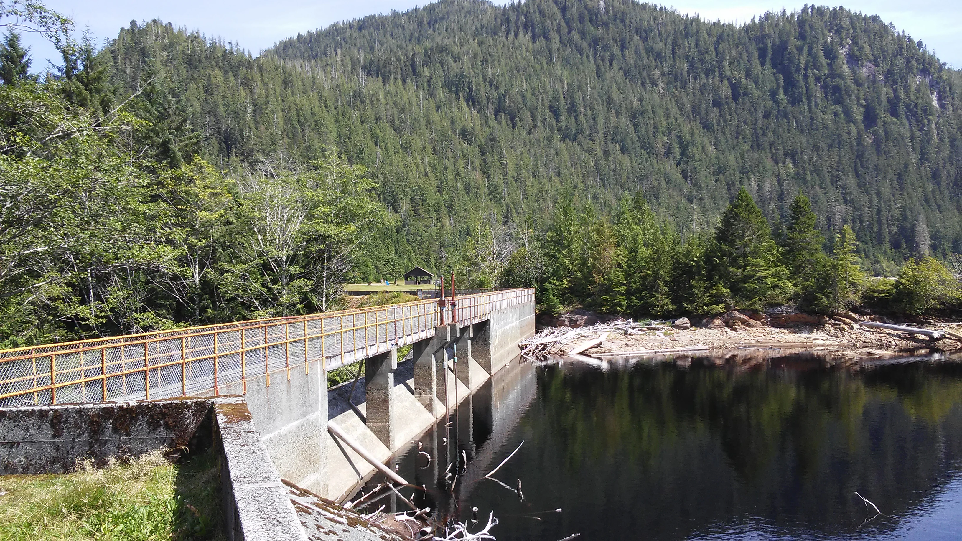
A concrete dam with a metal railing crossing a section of Diana Lake, backed by a densely forested mountainside.
A view of the dam structure and Diana Lake with the surrounding forest and mountains.

Diana Lake Provincial Park conservation status and protection priorities

Diana Lake Provincial Park's conservation significance lies in its combination of freshwater, coastal temperate rainforest, and blanket bog habitats within a single compact area on British Columbia's North Coast. Although small at 233 hectares, it preserves a representative slice of several sensitive ecosystems that face pressures from forestry, development, and climate change elsewhere in the region.

The park's intact stream and lake systems, capable of supporting all five Pacific salmon species along with steelhead, rainbow trout, and Dolly Varden, indicate functioning aquatic habitat and intact riparian forests. This makes the park an important reference site for watershed condition on the North Coast.

Its blanket bogs and surrounding coastal rainforest also contribute to landscape-level conservation values. Bogs act as long-term carbon stores and support specialized hydrological processes, while the old-growth forest provides habitat structure for wildlife and helps regulate local water cycles. Managed by BC Parks since 1980, the park forms a durable node in the network of protected natural areas along the Highway 16 corridor, safeguarding ecological processes that extend well beyond its boundaries.

Top sights and standout views in Diana Lake Provincial Park

Diana Lake Provincial Park's most distinctive quality is the way it compresses multiple North Coast ecosystems into one small, accessible area. Visitors encounter coastal temperate rainforest along Diana Creek, open blanket bogs on the route toward MacDonald Peak, and the broad freshwater expanse of Diana Lake itself, all within a short distance of Prince Rupert.

The park's freshwater richness is a defining highlight: the presence of all five Pacific salmon species, alongside steelhead, rainbow trout, and Dolly Varden trout, elevates the lake and creeks to a genuinely productive salmonid habitat. Combined with its scenic shoreline, rugged forest trails, and proximity to the Highway 16 corridor, the park stands out as a compact, ecosystem-rich gateway to the wider North Coast landscape.

Best time to visit Diana Lake Provincial Park

Diana Lake Provincial Park operates as a seasonal day-use area, generally accessible from mid-May through mid-September, and visiting within this window allows the full range of trail and lake experiences. Late spring and early summer bring fresh green growth to the rainforest and active conditions along Diana Creek, while the longer daylight hours of midsummer make lake and trail exploration more comfortable.

Season choice also shapes what visitors see. The wetter months emphasize the lushness of the rainforest and the saturation of the blanket bogs, while drier spells in mid to late summer can provide calmer lake conditions and clearer views across the water. Wildlife interest remains a constant, with salmon runs typically punctuating the warmer months and forest and bog habitats supporting bird and mammal activity throughout the accessible season.
Monthly climate preview

Long term temperature ranges and monthly precipitation averages for British Columbia

Diana Lake Provincial Park Climate Normals and Annual Weather Patterns

Diana Lake Provincial Park records measured monthly temperature values spanning from negative lows to warm summer maximums alongside varying precipitation rates across the year. Reviewing the complete twelve month profile provides deeper insight into long term climate normals and representative point measurements.
Annual mean5 °C
-1 °C13 °C
Jan-1°
Feb-1°
Mar
Apr
May
Jun11°
Jul13°
Aug13°
Sep11°
Oct
Nov
Dec-1°
Warmest month
August

13.2 °C

Coolest month
January

-1.3 °C

Wettest month
November

10.7 mm/day

Driest month
May

4.4 mm/day

Park location guide

Geography guide, regional context, and park location map for Diana Lake Provincial Park

Diana Lake Provincial Park park geography, regions, and map view in Canada

Understand where Diana Lake Provincial Park sits in Canada through a broader geographic reading of the surrounding landscape, nearby location context, and its mapped position within the national park landscape.

How Diana Lake Provincial Park fits into Canada

Canada is a federal parliamentary constitutional monarchy spanning North America from the Atlantic to the Pacific and Arctic Oceans. With a population of over 41 million, it is officially bilingual in English and French at the federal level. The country gained independence from the United Kingdom through a gradual process culminating in 1982.

Wider geography shaping Diana Lake Provincial Park in Canada

Canada occupies the northern portion of North America, sharing its longest international border with the United States. The country extends from the Atlantic Ocean to the Pacific Ocean and northward into the Arctic Ocean, giving it the longest coastline of any nation.

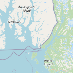
Map view of Diana Lake Provincial Park

Use this park location map to pinpoint Diana Lake Provincial Park in Canada, understand its exact geographic position, and read its mapped placement within the surrounding landscape more clearly.

Pigeon | © OpenStreetMap contributors

Location context for Diana Lake Provincial Park

British Columbia

Examine coastal rainforests, freshwater lakes, and wetland terrain through park imagery

Diana Lake Provincial Park Photos and Landscapes: Visual Scenery Explorer

Visual documentation reveals the layered geography of Diana Lake Provincial Park, spanning coastal temperate rainforests, freshwater lakeshores, and open blanket bogs. Photographic archives provide clear reference value for understanding North Coast ecosystems, riparian habitats, and upland terrain profiles.

A wide, scenic view of a calm, reflective lake surrounded by dark evergreen forest and mountains in the distance, with a fallen tree branch in the foreground.

A teepee-shaped sculpture made of light-colored driftwood poles standing on a sandy lakeshore with a green, tree-covered mountain in the background under a blue sky with white clouds.

A calm, reflective wetland pool surrounded by a dense temperate forest with tall trees and dappled sunlight filtering through the canopy.

A dense forest landscape with a mix of evergreen trees and standing dead trees against a clear blue sky, featuring a boggy ground surface in the foreground.

A concrete dam with a metal railing crossing a section of Diana Lake, backed by a densely forested mountainside.

Park atlas

Compare regional coastal rainforests, freshwater lakes, and connected North Coast protected landscapes

Explore Other Parks Near Diana Lake Provincial Park and Surrounding Protected Areas

Browse nearby national parks and protected areas sharing the maritime climate and aquatic geography of Diana Lake Provincial Park. Comparing adjacent reserves reveals broader ecological patterns across the rugged temperate rainforests and wetland corridors of coastal British Columbia.
A soft watercolor painting of a winding river flowing through a lush, green landscape with forested hills in the background.
Nature reserveBritish Columbia
About 9.6 km away#1 closest

East

Gamble Creek Ecological Reserve: Protected Nature Reserve Geography and Forest Map

British Columbia North Coast forest and peatland research landscape.

Situated on the North Coast of British Columbia, Gamble Creek Ecological Reserve is a designated nature reserve comprising forest and bog ecosystems. The protected area serves as an important site for studying plant communities, including sphagnum moss and coastal bog species, within a unique altitudinal transition between coastal hemlock and subalpine zones.

Area
10.26 km²
Established
1991
IUCN
Ia
Relief
Mixed relief
Watercolor painting of a coastal scene with green islands, coniferous trees, and soft, hazy mountains in the background, set against a white background.
Marine protected areaBritish Columbia
About 11 km away#2 closest

Southwest

Kitson Island Marine Provincial Park Map and Coastal Protected Area Atlas

Protected island and estuarine landscape in British Columbia

Kitson Island Marine Provincial Park encompasses a vital coastal island and the adjacent Flora Bank at the mouth of the Skeena River. This protected marine environment provides a rare example of accessible sandy beach terrain on the North Coast. Use this atlas resource to understand the park boundaries, island geography, and estuarine interface within the broader Inside Passage conservation network.

Area
0.45 km²
Established
1993
IUCN
II
Relief
Lowland
State or regional parkBritish Columbia
About 52 km away#3 closest

Northeast

Khutzeymateen Provincial Park: Protected Wilderness and Coastal Forest Geography

North Coast British Columbia protected area and estuary map.

Khutzeymateen Provincial Park represents a pivotal conservation achievement on the British Columbia North Coast. This wilderness sanctuary protects a critical estuarine complex where rugged mountain ranges meet a sheltered Pacific inlet. Beyond its designation as a grizzly bear stronghold, the park holds globally significant old-growth Sitka spruce forests, providing a rare look at an intact temperate rainforest landscape.

Area
450.52 km²
Established
1994
IUCN
Ib
Relief
Mountain
A soft watercolor illustration depicting a calm river scene with evergreen trees, a grassy riverbank, and distant rolling hills in pale green and pink tones.
State or regional parkBritish Columbia
About 58 km away#4 closest

East

Exchamsiks River Provincial Park: Protected Old-Growth Forest Geography in British Columbia

A rare maritime Sitka spruce landscape in the Skeena River estuary

Situated at the meeting of the Exchamsiks and Skeena rivers, this provincial park protects a significant stand of unlogged old-growth coastal rainforest. The terrain provides a compact, ecologically essential example of the temperate habitat characteristic of British Columbia's north coast, featuring moisture-loving spruce and salmonberry understory landscapes.

Area
0.182 km²
Established
1956
Relief
Lowland
Climate
Temperate
A horizontal watercolor painting showing a calm inlet surrounded by forested hills and distant mountains.
State or regional parkBritish Columbia
About 68 km away#5 closest

Southeast

Klewnuggit Inlet Marine Provincial Park: Regional Geography and Protected Area Mapping

Coastal inlet, freshwater lakes, and northern forest ecosystems.

Klewnuggit Inlet Marine Provincial Park showcases the dramatic meeting of mountain, forest, and sea. Spanning from the sheltered waters of the Grenville Channel to inland freshwater systems, the park offers a detailed study of northern coastal geography, fjord-like marine channels, and diverse bird and marine wildlife habitats.

Area
18 km²
Established
1993
IUCN
II
Relief
Mixed relief
State or regional parkBritish Columbia
About 106 km away#6 closest

Northeast

Kitsumkalum Provincial Park: Geography and Landscape Atlas of Northern British Columbia

Mapped protected areas and forest terrain in the Skeena region

Kitsumkalum Provincial Park serves as a compact protected node within the mountainous landscape of northern British Columbia. This record details the park's transition from lake to river outlet, the surrounding coniferous forests, and the geographic significance of the Skeena watershed. Gain spatial insight into the park boundaries and the historical context of its shoreline where early homesteading once flourished.

Area
0.4 km²
Established
1946
IUCN
II
Relief
Lowland
A soft watercolor illustration depicting a winding creek bordered by pine forests, with rolling mountains in the background, set against a plain white background.
State or regional parkBritish Columbia
About 122 km away#7 closest

East

Kleanza Creek Provincial Park: Coast Mountains Canyon and Salmon Protected Landscape

Regional protected geography in northwestern British Columbia

Kleanza Creek Provincial Park offers an intimate look at a rugged Coast Mountains landscape. The area is defined by its deep, forested rock canyons and the cascading waters of Kleanza Creek, which serve as essential habitat for spawning pink salmon. This protected site retains historical significance from nineteenth-century placer mining and provides a compact example of the complex terrain found in this part of British Columbia.

Area
2.69 km²
Established
1956
Relief
Mountain
Climate
Temperate
Protected landscapeBritish Columbia
About 154 km away#8 closest

West

Duu Guusd Heritage Site/Conservancy: Coastal Geography and Protected Land Map

A unified land and sea protected landscape in Haida Gwaii, British Columbia

Spanning over 227,000 hectares, Duu Guusd Heritage Site/Conservancy creates a massive protected corridor along the Pacific coast of British Columbia. This area links terrestrial forest ecosystems with marine waters, preserving complex island landscapes and significant Haida cultural sites throughout the northwestern corner of Graham Island.

Area
2,277.12 km²
Established
2008
IUCN
II
Relief
Mixed relief

Common questions about visiting, size, designation, and location context for Diana Lake Provincial Park

Diana Lake Provincial Park FAQs for park facts, access, geography, and protected area context

Find quick answers about Diana Lake Provincial Park, including protected-area facts, park geography, trail and visitor context, and how the park fits into its surrounding country and regional landscape.
MoriAtlas Explorer

Continue Your Protected Areas Search Across the Global Atlas

Deepen your exploration by continuing the structured search for national parks and protected areas worldwide. Utilize the comprehensive filtering capabilities to compare different conservation landscapes and refine your understanding of global park geography. Discover more about the distribution and characteristics of protected natural areas.

Global natural geography