

Mori Atlas logo
Nature reserveDippelsdorfer Teich

A comprehensive look at the geography, heritage railway embankments, and managed pond environment.

Dippelsdorfer Teich Nature Reserve: Exploring the Historic Saxon Pond Landscape in Meißen

Dippelsdorfer Teich stands as a prominent feature within the historic Moritzburg pond landscape near Dresden. This nature reserve, located in the Landkreis Meißen, showcases the long tradition of Saxon water management and cultural landscape engineering. The area is defined by its open water surface, surrounding woodland edges, and the narrow gauge railway embankment that runs directly across the water.

pond lakehistoric reservoirTeichwirtschaftMoritzburg TeichgebietSaxon pond landscapenature protection area
A flat-style digital illustration showing a waterfall in the distance flowing into a body of water, with a small building on the shore, trees, and tall reeds in the foreground.

Dippelsdorfer Teich

Nature reserve

Park overview

Structured park overview, official facts, and landscape profile for Dippelsdorfer Teich

Dippelsdorfer Teich park facts, protected area profile, and essential visitor context

Review the core facts for Dippelsdorfer Teich, including designation, size, terrain, visitor scale, habitats, and operating context in one park-focused overview.

About Dippelsdorfer Teich

The Dippelsdorfer Teich is a constructed freshwater pond located in the Saxon countryside north of Dresden, within the Landkreis Meißen. It forms part of the broader Moritzburger Teichgebiet, a tightly knit cluster of pond landscapes that has defined the rural character of the area between Radebeul, Moritzburg, and the northern outskirts of Dresden for several hundred years. The pond takes its name from the cluster of houses known as Dippelsdorf, a hamlet that today is part of the Friedewald locality in the municipality of Moritzburg.

Like many of the Moritzburg ponds, the Dippelsdorfer Teich is a deliberately engineered water body rather than a natural lake. It was created through the damming of the Lößnitzbach, and a diversion also brings in water from the Reichenberger Bach. Together, these inflows feed the pond and drain eastward via the Lößnitzbach toward the Elbe. The pond's dam is approximately 170 meters long and 6 meters across the crest, and the pond functions as a reservoir with a usable storage volume in the low hundreds of thousands of cubic meters. These proportions make it a medium-scale but architecturally significant water feature within the wider pond network.

The lake is a true multi-use landscape. It serves practical water-management and fisheries functions, supports designated nature protection areas within the Landkreis Meißen, and at the same time acts as a focal point for nearby recreation. The Strandbad Friedewald-Dippelsdorf provides a long-established lakeside bathing area with its distinctive red building on the shore, and the adjacent Bad Sonnenland camping area extends the lake's role as a regional leisure destination. Across the water, a roughly 210-meter-long embankment carries the tracks of the Lößnitzgrundbahn, one of Saxon's best-known narrow-gauge heritage railways, connecting Radebeul Ost with Moritzburg and beyond to Dippelsdorf.

The cultural and historical character of the Dippelsdorfer Teich extends beyond engineering and tourism. The early Expressionist painter Ernst Ludwig Kirchner, closely associated with the artistic life of nearby Dresden, painted the figure composition 'Vier Badende' at the Friedewald lido next to the pond, embedding the site in the history of modern German art. In this combination of historic water engineering, ongoing ecological management, recreational use, low-key visitor infrastructure, and an unexpected railway crossing, the Dippelsdorfer Teich captures the layered identity of the Moritzburg pond landscape as a whole.

Quick facts and research context for Dippelsdorfer Teich

The Dippelsdorfer Teich lies in the Landkreis Meißen in the Free State of Saxony, Germany, north of the city of Dresden. It belongs to the larger Moritzburger Teichgebiet, a connected system of historic ponds that has shaped the regional landscape for centuries. The pond is fed by the Lößnitzbach and, via a diversion, by the Reichenberger Bach, with the Lößnitzbach serving as its outflow. Its water surface is generally given as around 69 hectares, with an older figure of about 42 hectares also appearing in older sources. The pond dam is roughly 170 meters long and approximately 6 meters wide, and the pond is estimated to have a storage volume of around 0.45 million cubic meters drawing on a catchment of about 5.1 square kilometers. The area is part of a designated nature protection zone within the Landkreis Meißen and serves multiple functions, including fish farming, nature conservation, and local recreation.

Protection and recognition

Examine documented protection scope, management details, and recognition data.

Dippelsdorfer Teich Protection Status and Terrestrial Conservation Records

Terrestrial protection records for Dippelsdorfer Teich outline established conservation boundaries and administrative frameworks. Verified status facts provide clear context for ongoing management scope without assuming external designations.

Protection details

Protection scope
Terrestrial
Transboundary protection
No
Park context

Deeper park guide and search-rich context for Dippelsdorfer Teich

Dippelsdorfer Teich history, landscape, wildlife, and travel context

Explore Dippelsdorfer Teich through its history, landscape character, ecosystems, wildlife, conservation priorities, cultural context, and seasonal travel timing in a structured park guide built for atlas discovery and search intent.

Why Dippelsdorfer Teich stands out

The Dippelsdorfer Teich is best known as one of the defining ponds of the historic Moritzburg pond landscape, a centuries-old reservoir system north of Dresden. It is particularly recognizable for the unusual sight of the Lößnitzgrundbahn, a narrow-gauge heritage railway, crossing its surface on a low dam between Dippelsdorf and Moritzburg. The pond also carries cultural weight beyond its practical water-management role: the early 20th-century Expressionist painter Ernst Ludwig Kirchner created the work 'Vier Badende' (Four Bathers) at the Strandbad Friedewald on its shore, anchoring the lake in Saxon art history. Together, the combination of historic pond economy, ongoing nature protection, and cultural associations with Kirchner's modernist masterpiece gives the Dippelsdorfer Teich a distinctive identity within the Moritzburg region.
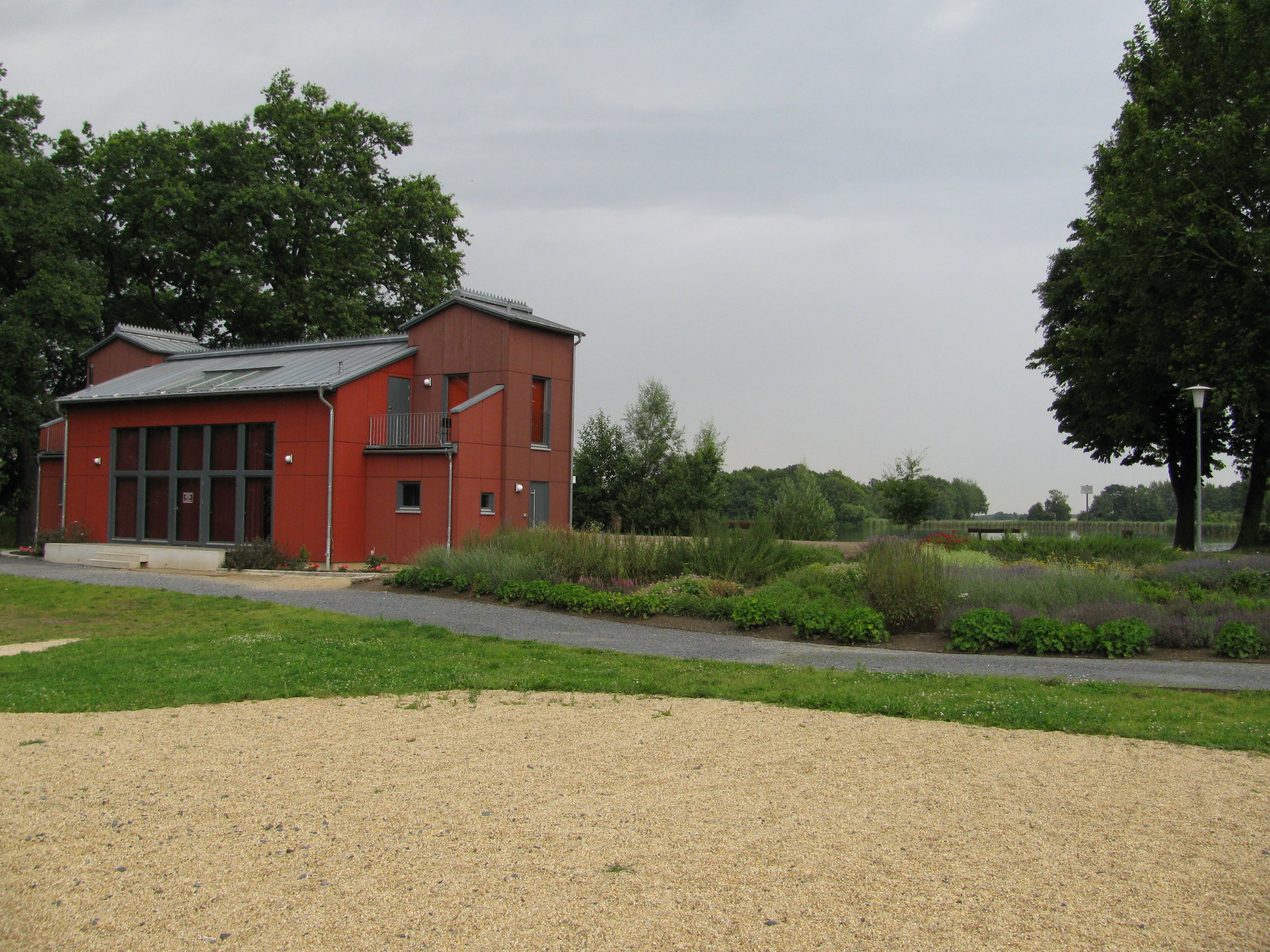
A modern two story red building with a gray metal roof stands next to a paved path, surrounded by grass and low shrubs under an overcast sky.
The distinctive red building on the shores of Dippelsdorfer Teich.

Dippelsdorfer Teich history and protected-area timeline

The Dippelsdorfer Teich was created as part of the systematic development of the Moritzburg pond landscape in the 16th century. The most commonly cited founding year is 1528, though this date is regarded as approximate and based on the traditional construction timeline of the surrounding Moritzburger Teiche.

Like other ponds in this system, it was built by damming the Lößnitzbach and connecting additional inflow through a diversion of the Reichenberger Bach. This reflects the classic Saxon approach to pond landscapes, in which streams were carefully redirected and impounded to create controlled reservoirs serving fisheries, water regulation, and later landscape and recreational purposes. Over the following centuries, the pond became an embedded part of the rural economy around Moritzburg and the surrounding villages, including the hamlet of Dippelsdorf from which it takes its modern name.

In the 20th century, the Dippelsdorfer Teich gained a cultural layer beyond its practical origins. The Strandbad Friedewald on its shore became a favored recreation spot for residents of Dresden and the surrounding towns, and it was here that Ernst Ludwig Kirchner painted the work 'Vier Badende', giving the pond a notable place in the history of German Expressionism. The construction of the railway embankment for the Lößnitzgrundbahn, which continues to operate as a heritage line, added another structural and touristic landmark, and the pond itself gained formal recognition within the nature protection framework of the Landkreis Meißen.

Dippelsdorfer Teich landscape and geographic character

The Dippelsdorfer Teich occupies a gentle lowland setting typical of the northern Dresden countryside, framed by woods, meadows, and the small rural settlements of the Moritzburg region. Its open water surface, generally given as close to 69 hectares, sits within a shallow basin shaped by centuries of human water management, with gently sloping banks along stretches of shoreline and reed and wetland vegetation in calmer bays.

The defining man-made feature of the landscape is the dam, approximately 170 meters long and around 6 meters wide at the crest, which closes off the basin and holds back the waters of the Lößnitzbach and the diverted Reichenberger Bach. A 210-meter embankment extension carries the Lößnitzgrundbahn across the pond between Dippelsdorf and Moritzburg, creating the unusual visual of a narrow-gauge railway running low across the water surface. On the banks, the red Strandbad Friedewald-Dippelsdorf building and associated bathing grounds form a recognizable local landmark, while the broader surroundings include mixed forest, farmland, and other ponds belonging to the connected Moritzburger Teichgebiet.

Because the pond sits within a managed pond landscape rather than a wild natural basin, the terrain feels openly cultivated: trimmed embankment lines, occasional viewing clearances, and gentle transitions into neighboring fields and woodlands. This combination of engineered water body and gently rolling Saxon countryside gives the Dippelsdorfer Teich its particular character as a working cultural landscape.
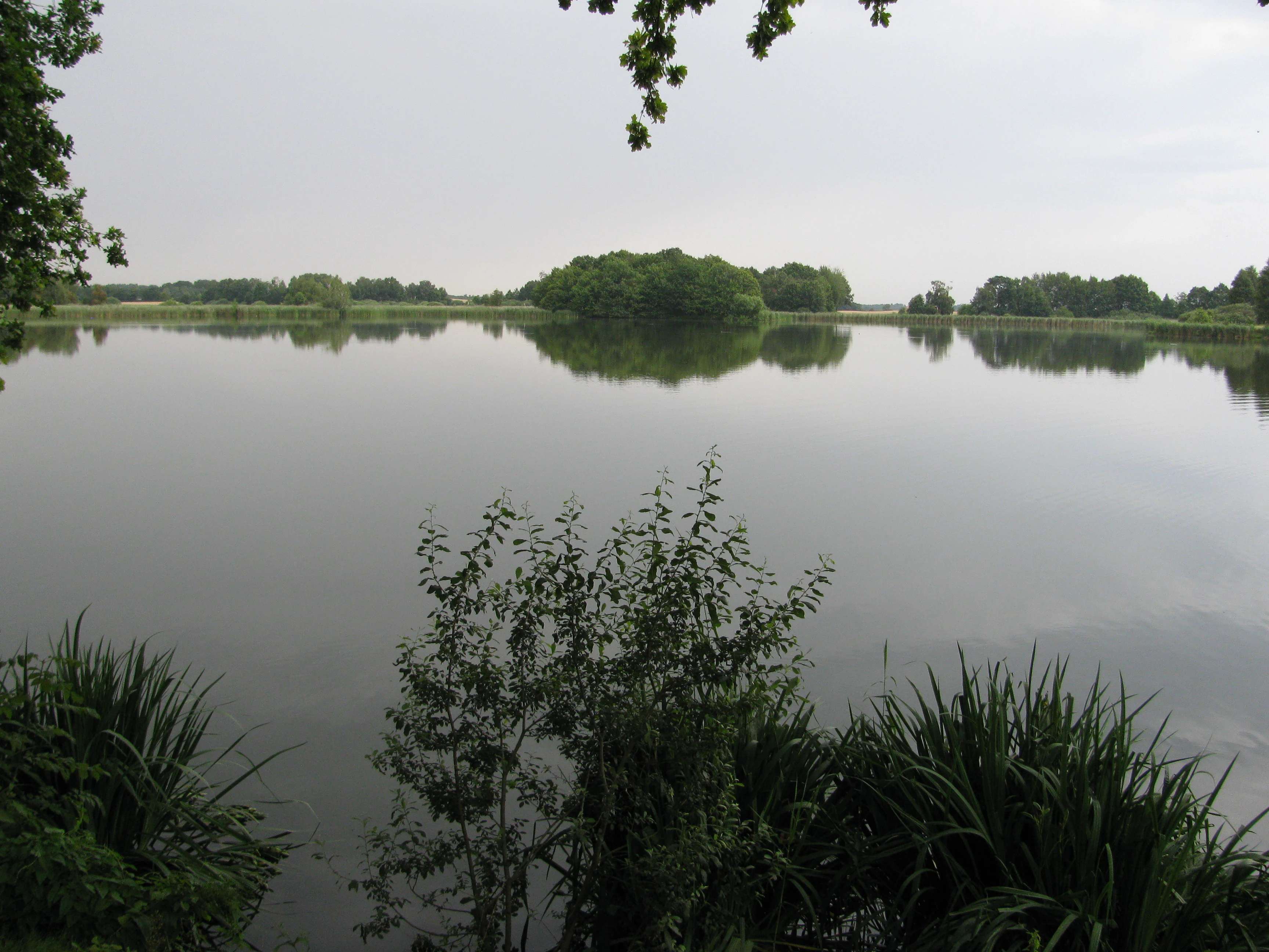
A wide, calm pond with reflective water surrounded by green trees and shrubs on an overcast day.
A calm view across the Dippelsdorfer Teich in Moritzburg.

Dippelsdorfer Teich ecosystems, habitats, and plant life

Ecologically, the Dippelsdorfer Teich exemplifies a managed Saxon pond habitat. Its inflows and outflows, riparian shallows, and adjacent woodland edges support a mix of aquatic, wetland, and forest-edge communities that are characteristic of the Moritzburger Teichgebiet as a whole.

The pond is especially valuable for waterbird habitat and freshwater ecology. Quiet bays, reed fringes, and the lake's relatively shallow character offer feeding and resting conditions for ducks, herons, and other water-associated birds, while the connecting streams and small inlets provide spawning and refuge areas for native fish species relevant to regional fisheries. Surrounding woodland and meadow belts add terrestrial habitat for small mammals, amphibians, and a wide range of typical central European forest species.

Because the Dippelsdorfer Teich lies within a network of nature protection areas in the Landkreis Meißen, its ecological function forms part of a larger landscape-level conservation system rather than an isolated site. Management balances fish farming, water-level control, and habitat protection, allowing the pond to continue functioning as a working fishery while also contributing to the mosaic of protected freshwater and wetland habitats in the northern Dresden region.

Dippelsdorfer Teich wildlife and species highlights

The wildlife profile of the Dippelsdorfer Teich reflects its character as a managed lowland pond within a broader pond and forest landscape. Waterbirds are the most visible faunal feature, with the lake and its fringes providing habitat for typical central European pond species, including various ducks, coots, and moorhens, as well as wading birds such as herons along the reed-lined and shallow sections.

Fish are another central component of the lake's fauna, given its long-standing role in regional fish farming. Common pond species typical of Saxon Teichwirtschaft, including carp and associated coarse fish, inhabit the basin and are part of the ongoing managed fishery. Amphibians such as frogs and toads likely use the shoreline shallows and adjacent wet areas during their breeding season, taking advantage of the quieter zones of the lake.

In the surrounding woodlands and meadows, the pond blends with broader Saxon lowland fauna. Small mammals, woodland birds, and the usual cast of forest-edge species occupy the banks and connecting forest belts. While the site does not host large charismatic mammals, the combination of aquatic and terrestrial habitats around the Dippelsdorfer Teich gives it a representative and ecologically meaningful wildlife character for the Moritzburg region.

Dippelsdorfer Teich conservation status and protection priorities

Within the Landkreis Meißen, the Dippelsdorfer Teich is formally recognized as part of the regional system of protected areas. It is listed among the Naturschutzgebiete of the district and functions as a component of the larger Friedewald und Moritzburger Teichgebiet, a protected landscape complex that safeguards the historic pond systems north of Dresden.

Its conservation value lies primarily in the landscape-scale mosaic it preserves. Managed freshwater habitats, reed margins, riparian woodland, and meadow transitions combine into a coherent ecological network that supports waterbirds, amphibians, and fish populations while also maintaining traditional fisheries. Because the pond is embedded within a wider protected area, its importance extends beyond the water itself to the way it connects with neighboring ponds, streams, and forest patches.

Active management balances fish production, controlled water levels, recreational use, and habitat preservation. This multi-use framework ensures that the Dippelsdorfer Teich continues to serve as both a working fishery and a functioning nature protection area, illustrating the Saxon approach of integrating centuries-old pond culture with modern ecological objectives.

Dippelsdorfer Teich cultural meaning and human context

The Dippelsdorfer Teich is embedded in the rural cultural landscape around Moritzburg, a region strongly associated with the Moritzburg Castle hunting estate and the long tradition of pond cultivation in northern Saxony. The nearby hamlet of Dippelsdorf, after which the pond is named, is one of several small historic villages that grew alongside the development of the pond system.

The most striking cultural association of the lake is its link to Ernst Ludwig Kirchner, a leading figure of German Expressionism and part of the Die Brücke group that emerged in Dresden. Kirchner painted 'Vier Badende' at the Strandbad Friedewald on the lake's shore, embedding the Dippelsdorfer Teich in early 20th-century modernist art history. A few decades later, the establishment of the Lößnitzgrundbahn as a heritage narrow-gauge railway added a distinct industrial and touristic cultural layer, turning the dam across the pond into a familiar regional landmark.

Together, the pond reflects a layered Saxon identity: medieval and early modern water management, regional village life around Moritzburg, modernist artistic memory, and a contemporary heritage railway culture that continues to draw visitors to the lakeside.

Top sights and standout views in Dippelsdorfer Teich

Among the Dippelsdorfer Teich's strongest distinguishing features are the railway embankment of the Lößnitzgrundbahn that runs across the water, the historic 16th-century damming of the Lößnitzbach that gave the lake its present shape, and the association with Ernst Ludwig Kirchner's Expressionist painting 'Vier Badende' from the Friedewald lido.

The lake also stands out as a well-integrated example of the Saxon Teichwirtschaft tradition, combining active fish farming with formal nature protection status within the Landkreis Meißen. The combination of the Strandbad Friedewald-Dippelsdorf lido, the Bad Sonnenland camping area, and the network of neighboring Moritzburg ponds adds a strong recreational and landscape-level dimension, making the Dippelsdorfer Teich both a working historical landscape and a recognizable nature-based destination in the northern Dresden countryside.

Best time to visit Dippelsdorfer Teich

As a working pond in a Saxon lowland setting, the Dippelsdorfer Teich offers different experiences across the seasons. Late spring and summer are the most vivid periods, when the Strandbad Friedewald-Dippelsdorf is open, the camping area is in full use, and the surrounding woodlands and meadows are at their greenest. This is also when waterbird activity along the reed fringes is easiest to observe.

Autumn brings quieter conditions, softer light over the water, and the most atmospheric sight of the Lößnitzgrundbahn steam or diesel services crossing the dam. Winter visits tend to be calmer and more low-key; weather conditions and any seasonal operation of recreation facilities can affect access, but the open pond landscape retains its gentle rural character year-round. Broadly speaking, late spring through early autumn offers the richest mix of natural scenery, recreational activity, and typical Saxon pond-landscape atmosphere.

Monthly climate preview

Long-term representative measurements of temperature and precipitation rhythm in Meißen

Dippelsdorfer Teich Climate Normals and Monthly Weather Patterns

Temperature and precipitation measurements for Dippelsdorfer Teich trace a recorded annual cycle from subzero winter minima to warm summer maximums across twelve distinct months. Examining the complete monthly climate normals provides deeper context regarding long-term environmental averages at this specific protected coordinate.
Annual mean8 °C
-2 °C19 °C
Jan-2°
Feb-1°
Mar
Apr
May13°
Jun17°
Jul19°
Aug19°
Sep14°
Oct
Nov
Dec-1°
Warmest month
July

19.1 °C

Coolest month
January

-1.8 °C

Wettest month
July

2.8 mm/day

Driest month
April

1.3 mm/day

Park location guide

Geography guide, regional context, and park location map for Dippelsdorfer Teich

Dippelsdorfer Teich park geography, regions, and map view in Germany

Understand where Dippelsdorfer Teich sits in Germany through a broader geographic reading of the surrounding landscape, nearby location context, and its mapped position within the national park landscape.

How Dippelsdorfer Teich fits into Germany

Germany is a federal republic in Western and Central Europe with a population of over 83 million across sixteen constituent states. It is Europe's largest economy by nominal GDP and a major global exporter and importer. The capital is Berlin, and the country borders Denmark, Poland, Czech Republic, Austria, Switzerland, France, Luxembourg, Belgium, and the Netherlands.

Wider geography shaping Dippelsdorfer Teich in Germany

Germany is located in Western and Central Europe, spanning 357,022 km². It borders Denmark to the north, Poland and the Czech Republic to the east, Austria and Switzerland to the south, and France, Luxembourg, Belgium, and the Netherlands to the west. The country has coastlines on the Baltic Sea and North Sea to the north, with the Alps located in the southern region.

Map view of Dippelsdorfer Teich

Use this park location map to pinpoint Dippelsdorfer Teich in Germany, understand its exact geographic position, and read its mapped placement within the surrounding landscape more clearly.

Pigeon | © OpenStreetMap contributors

Location context for Dippelsdorfer Teich

MeißenSaxony

Explore protected area views, historical water management infrastructure, and lowland wetland habitats.

Dippelsdorfer Teich Photos and Landscape Scenery: Visualizing the Historic Moritzburg Pond Environment

Visual documentation captures the unique wetland terrain, engineering heritage, and surrounding woodland margins of Dippelsdorfer Teich. Examining these field photographs reveals the distinct character of a managed Saxon cultural landscape and its protected aquatic habitats.

A modern two story red building with a gray metal roof stands next to a paved path, surrounded by grass and low shrubs under an overcast sky.

A vintage steam locomotive pulling passenger carriages across a bridge over a lake, with dense forest in the background.

A wide, calm pond with reflective water surrounded by green trees and shrubs on an overcast day.

Park atlas

Compare adjacent lowland waters, regional ponds, and protected Saxon landscapes.

Explore Protected Areas and Parks Near Dippelsdorfer Teich

Browse other parks near Dippelsdorfer Teich to discover connected water management basins and surrounding nature reserves across the region. Regional comparisons reveal how historical pond systems shape the broader protected terrain north of Dresden.
A watercolor painting showing a calm pond with a small island of green trees and distant rolling hills under a soft pink and yellow sky.
Nature reserveMeißen District
About 4.8 km away#1 closest

Northeast

Frauenteich Moritzburg: Mapping the Protected Wetland Landscapes of Meißen District

Glacial pond basins and diverse forest habitats in Saxony.

Frauenteich Moritzburg serves as a core component of Saxony's pond landscape, protecting a rich sequence of shoreline vegetation and open water. Its geography reflects the results of ancient glacial activity, creating a unique environment where sandy ridges and wet meadows coexist. This nature reserve provides essential refuge for bird populations, making it a focal point for understanding the natural, protected terrain within the broader Meißen District environment.

Area
2.02 km²
Established
1954
IUCN
IV
Relief
Lowland
Nature reserveSachsen
About 11 km away#2 closest

Northeast

Waldmoore bei Großdittmannsdorf: A Protected Wetland Landscape in Sachsen, Germany

Mapping forest mires and rare swamp woodland habitats

Waldmoore bei Großdittmannsdorf represents a carefully maintained nature reserve in eastern Germany, spanning roughly 93 hectares of forest mire and bog structures. The site supports a rare transition of swamp woodland, sedge-rich wet stands, and spring flushes within the Laußnitzer Heide. As a designated Natura 2000 area, it plays a key role in safeguarding regional wetland connectivity and providing a refuge for specialist flora and fauna in the Saxon landscape.

Area
0.935 km²
Established
2000
IUCN
IV
Nature reserveSachsen
About 15 km away#3 closest

Northwest

Winzerwiese und Gosebruch: Protected Nature Reserve and Valley Geography in Sachsen

Mapping protected wet meadows and floodplain woodlands

Winzerwiese und Gosebruch is a distinctive nature reserve in Sachsen, Germany, centered on a small valley along the Gosebach stream. This protected area creates a dense mosaic of wet meadow, marshy woodland, and dry deciduous forest, offering a significant look at the region's diverse botanical landscape and river-valley geography.

Area
0.116 km²
Established
1967
IUCN
IV
A pale, soft watercolor painting depicting a small arched bridge crossing a gentle stream within a rolling green valley.
Protected landscapeSaxony
About 15 km away#4 closest

East

Seifersdorfer Tal Protected Landscape and Cultural Heritage in Saxony

A historic garden monument and river valley ecosystem

The Seifersdorfer Tal is a protected landscape defining the Große Röder valley. Beyond its cultural status as one of Germany's earliest English-style landscape gardens, the area serves as a vital riverine corridor and nature reserve. The terrain offers a unique blend of rocky outcrops, wooded slopes, and meadows linked by historic footpaths and 18th-century allegorical monuments.

Area
2.88 km²
Established
1960
Relief
Upland
Climate
Temperate
Nature reserveFreistaat Sachsen
About 16 km away#5 closest

South

Windberg Nature Reserve: Mapping the Forested Ridge and Protected Landscape of Saxony

Geology, mining heritage, and protected oak-beech forest ecosystems

Windberg serves as the prominent local landmark for Freital, defined by its elongated forested plateau and complex tectonic geography. This nature reserve offers a study in the intersection of environmental conservation and human industrial history, featuring Saxony's deepest cave and varied habitats within the eastern Ore Mountains foothills.

Established
1967
Relief
Mountain
Climate
Temperate
Access
Easy access
Watercolor painting of a soft landscape featuring distant hills and foreground vegetation in shades of green, yellow, and soft red.
Nature reserveSachsen
About 18 km away#6 closest

Southeast

Dresdner Elbtalhänge Nature Reserve: Geography, Mapped Boundaries, and Landscape Context

An essential nature reserve along the Elbe valley in Sachsen

Dresdner Elbtalhänge captures the striking transition between the flat Elbe floodplain and the Westlausitz hill region. This detailed atlas entry covers the reserve's unique geomorphology, including its incised ravine systems, south-facing oak forests, and exposed rock formations that define its protected character within Sachsen.

Area
203.6 km²
Established
2007
IUCN
IV
A soft, light-toned watercolor painting of a low, rolling landscape with green hills, sparse vegetation, and a suggestion of wetland or pond in the foreground.
Nature reserveSachsen
About 19 km away#7 closest

Northwest

Seußlitzer und Gauernitzer Gründe: Protected Nature Reserve Map and Landscape Overview

Regional geography and habitat boundaries in the Sachsen Elbe valley.

Spanning steep slopes and narrow brook valleys on both sides of the Elbe, Seußlitzer und Gauernitzer Gründe is a defining nature reserve in Sachsen. This protected area supports a diverse mix of dry herbaceous vegetation and mature deciduous forest, serving as a critical component of the local ecological network within the broader Upper Elbe landscape.

Area
3.57 km²
Established
2013
IUCN
IV
Relief
Upland
A pale, soft watercolor illustration showing a horizontal landscape of light green trees, shrubs, and rolling grassy plains on a white background.
Nature reserveGermany
About 21 km away#8 closest

Southeast

Elbinseln Pillnitz und Gauernitz: A Study in Protected Saxon River Landscapes

Examining floodplain geography and rare river island ecosystems

Located in the Elbe valley between Dresden and Meissen, Elbinseln Pillnitz und Gauernitz preserves the final natural river islands within the state of Saxony. This protected nature reserve anchors a vital network of alluvial soils, riparian woodlands, and unarmored riverbanks, offering a unique perspective on the dynamic floodplain geography of Germany's major river corridors.

Area
0.235 km²
Established
2006
IUCN
IV
Relief
Lowland

Common questions about visiting, size, designation, and location context for Dippelsdorfer Teich

Dippelsdorfer Teich FAQs for park facts, access, geography, and protected area context

Find quick answers about Dippelsdorfer Teich, including protected-area facts, park geography, trail and visitor context, and how the park fits into its surrounding country and regional landscape.
MoriAtlas Explorer

Continue Your Protected Areas Search Across the Global Atlas

Deepen your exploration by continuing the structured search for national parks and protected areas worldwide. Utilize the comprehensive filtering capabilities to compare different conservation landscapes and refine your understanding of global park geography. Discover more about the distribution and characteristics of protected natural areas.

Global natural geography