Mori Atlas logo
Nature reserveRezerwat przyrody Doły Szczeckie

Tracing the mapped ravines, beech woodland boundaries, and upland terrain of this protected landscape

Rezerwat przyrody Doły Szczeckie: A Detailed Geographic Atlas of Poland's Karst Nature Reserve

Rezerwat przyrody Doły Szczeckie sits within the rolling Wzniesienia Urzędowskie hills of the Lublin Voivodeship, acting as a protected mosaic of karst landforms and mature broadleaf forests. This nature reserve, established in 1997, preserves a complex network of gorges and dry valleys that serve as a crucial refuge for European beech near the northeastern limit of the species range. The atlas data provides a clear view into the topography and forest community structures that define this upland region.

nature reservebroadleaf forestbeech forestkarst landscaperavines and gorgesupland terrain

Rezerwat przyrody Doły Szczeckie

Nature reserve

Park overview

Structured park overview, official facts, and landscape profile for Doły Szczeckie Nature Reserve

Doły Szczeckie Nature Reserve park facts, protected area profile, and essential visitor context

Review the core facts for Doły Szczeckie Nature Reserve, including designation, size, terrain, visitor scale, habitats, and operating context in one park-focused overview.

About Doły Szczeckie Nature Reserve

Doły Szczeckie Nature Reserve occupies a section of the Wzniesienia Urzędowskie hills, a mesoregion in the western part of the Lublin Voivodeship that forms a transitional upland landscape between the broader Polish uplands and the Vistula basin. The reserve lies within the Gościeradów commune in Kraśnik County and is managed as part of the Gościeradów Forest District, which oversees the surrounding state forest lands.

The character of the reserve is defined by the interplay between geology and forest cover. The underlying terrain exhibits karst and erosional features that have produced a strongly dissected topography of ravines, gorges, and dry valleys. Rather than forming an open karst landscape, these landforms are cloaked in natural forest, giving the area a wooded, rugged appearance that combines ecological value with scenic quality. Elevations within the reserve range from approximately 185 meters to about 270 meters above sea level.

The forest communities of Doły Szczeckie are notably diverse despite the relatively modest size of the protected area. In the more level sections, the woodland tends toward single-species or mixed stands dominated by beech and hornbeam. On the slopes and along the edges of dry valleys and gorges, the forest composition shifts toward mixed broadleaf communities incorporating sycamore maple, small-leaved linden, aspen, and additional hornbeam, reflecting the variation in soil moisture, exposure, and microclimate created by the dissected terrain.

Ecologically, the reserve is significant because it protects clustered populations of European beech near the northeastern boundary of the species' natural range in Poland. These beech stands are recognized as important for both scientific study and education, and the reserve's formal conservation purpose frames them explicitly in these terms. The reserve also preserves a layer of protected plant species in the shrub and herb layers, including several orchids and woodland perennials characteristic of mature deciduous forest.

A nature and forestry trail runs through the reserve, while a fragment of the county-level bicycle route known as "Rowerem do Europy" (By Bicycle to Europe) follows a hardened forest road along the reserve's boundary, providing accessible approaches to the area without intruding into the protected interior.

Quick facts and research context for Doły Szczeckie Nature Reserve

Doły Szczeckie is a partial, landscape and forest nature reserve under the management of the Gościeradów Forest District. It was created by order of the Minister of Environmental Protection, Natural Resources, and Forestry on 25 July 1997 and covers roughly 204 hectares, of which about 198 hectares are forested.

The reserve sits within the Wzniesienia Urzędowskie mesoregion of the Lublin Voivodeship, in the Gościeradów commune of Kraśnik County. Its defining features are karst landforms cut into the landscape as ravines, gorges, and dry valleys, and a forest cover dominated by beech and hornbeam with oak and mixed broadleaf communities on the slopes.

Protection and recognition

Documented terrestrial protection scope and administrative recognition records

Rezerwat przyrody Doły Szczeckie Protection Status and Conservation Data

Rezerwat przyrody Doły Szczeckie maintains a documented terrestrial protection scope within the regional conservation framework. Official records compile available management parameters and administrative designations for structured geographic analysis.

Protection details

Protection scope
Terrestrial
Park context

Deeper park guide and search-rich context for Doły Szczeckie Nature Reserve

Doły Szczeckie Nature Reserve history, landscape, wildlife, and travel context

Explore Doły Szczeckie Nature Reserve through its history, landscape character, ecosystems, wildlife, conservation priorities, cultural context, and seasonal travel timing in a structured park guide built for atlas discovery and search intent.

Why Doły Szczeckie Nature Reserve stands out

Doły Szczeckie is best known for protecting karst landforms overgrown by natural forest, and in particular for its clustered stands of European beech near the northeastern limit of the species' natural range in Poland. The reserve combines two strongly linked conservation values: a dissected, scenic topography of ravines, gorges, and dry valleys, and a broadleaf woodland system in which beech and hornbeam play a central role. It is also notable for a rich understory of protected herbaceous and shrub species typical of mature Central European deciduous forest.

Doły Szczeckie Nature Reserve history and protected-area timeline

Doły Szczeckie was formally designated as a nature reserve on 25 July 1997, through an order issued by the Minister of Environmental Protection, Natural Resources, and Forestry. The legal basis was published in the Polish Monitor of 1997, issue 56, item 532, which set out the reserve's boundaries, protection regime, and conservation purpose.

The reserve was created to safeguard a specific combination of natural assets: karst landforms carved into the local landscape and overgrown by natural forest, together with stands of European beech located near the northeastern edge of the species' natural distribution in Poland. Its stated purpose combines scientific study with educational use, reflecting a tradition in Polish nature protection of pairing ecological preservation with public understanding of forest ecosystems.

Following its establishment, the reserve has continued to be managed by the Gościeradów Forest District, which administers the surrounding state-owned forest lands. The reserve is designated as a partial protection reserve, allowing regulated forest use to continue under defined conditions rather than imposing full restrictions.

Doły Szczeckie Nature Reserve landscape and geographic character

The landscape of Doły Szczeckie is shaped by karst processes and subsequent erosion, which together have carved the local terrain into a network of ravines, gorges, and dry valleys. These features give the area its scenic, picturesque character and create the varied topography that defines the reserve.

The reserve lies within the Wzniesienia Urzędowskie mesoregion, a section of upland terrain in the western part of the Lublin Voivodeship. Local elevations span from about 185 meters to around 270 meters above sea level, producing clear differences in slope, exposure, and microclimate across short distances. The dissected hills, combined with dense forest cover, give Doły Szczeckie a wooded and visually enclosed character.

Doły Szczeckie Nature Reserve ecosystems, habitats, and plant life

Ecologically, Doły Szczeckie functions as a stronghold of natural broadleaf forest within the Wzniesienia Urzędowskie hills. Its habitats include more uniform beech and hornbeam stands on relatively level ground, as well as mixed broadleaf communities on the slopes and along the margins of ravines and dry valleys, where tree species composition becomes more varied.

The reserve's protection focuses on preserving these natural forest communities and the geological landforms they inhabit. Beech stands near the edge of the species' natural range are an especially important ecological feature, while the overall mosaic of forest types reflects the influence of topography and slope on woodland development.

In the shrub and herb layers, the reserve supports a notable community of protected plant species, including several woodland perennials and species associated with mature deciduous forest, contributing to the broader botanical value of the protected area.

Doły Szczeckie Nature Reserve conservation status and protection priorities

Doły Szczeckie was established to preserve a combination of geological and ecological values that complement each other: karst and erosional landforms overgrown by natural forest, and clustered stands of European beech near the northeastern limit of the species' natural range in Poland. The reserve's stated conservation purpose combines scientific research with educational use, recognizing these beech populations as important objects of study at a biogeographically significant boundary of the species' native distribution.

As a partial protection reserve, Doły Szczeckie maintains regulated forest management within defined limits rather than imposing complete restrictions. Management is carried out by the Gościeradów Forest District, which oversees both the reserve and the surrounding state forest lands, helping to integrate the protected area into the broader forested landscape of the region.

Top sights and standout views in Doły Szczeckie Nature Reserve

Among the most distinctive elements of Doły Szczeckie are its karst landforms: ravines, gorges, and dry valleys that give the reserve its scenic, dissected topography. Equally distinctive is its forest character, dominated by European beech and hornbeam in many stands, with mixed broadleaf communities on the slopes.

The reserve's protected plant community in the shrub and herb layers adds another layer of botanical interest, while the presence of a nature and forestry trail through the reserve and a segment of a county bicycle route along its boundary make the protected landscape approachable for visitors without compromising its core values.

Best time to visit Doły Szczeckie Nature Reserve

The reserve is most appealing in late spring and summer, when the broadleaf canopy is in full leaf and the understory of protected plant species is at its most visible. Autumn also offers a vivid display of forest color, while the geological features of the landscape remain visible year-round. Because the reserve is partially protected, visits are oriented around the designated nature and forestry trail and the boundary forest road rather than unrestricted access to the interior.
Monthly climate preview

Long-term temperature ranges and monthly precipitation records for Lublin Voivodeship

Rezerwat przyrody Doły Szczeckie Climate Normals and Annual Weather Patterns

Representative coordinates record mean monthly temperatures shifting from sub-zero winter minimums to warm summer peaks alongside steady precipitation rhythms. Detailed twelve-month climate tables provide complete statistical depth for analyzing long-term environmental patterns across the terrain.
Annual mean8 °C
-4 °C20 °C
Jan-4°
Feb-2°
Mar
Apr
May14°
Jun18°
Jul20°
Aug20°
Sep14°
Oct
Nov
Dec-2°
Warmest month
July

20.3 °C

Coolest month
January

-3.8 °C

Wettest month
July

2.7 mm/day

Driest month
January

1.2 mm/day

Park location guide

Geography guide, regional context, and park location map for Doły Szczeckie Nature Reserve

Doły Szczeckie Nature Reserve park geography, regions, and map view in Poland

Understand where Doły Szczeckie Nature Reserve sits in Poland through a broader geographic reading of the surrounding landscape, nearby location context, and its mapped position within the national park landscape.

How Doły Szczeckie Nature Reserve fits into Poland

Poland, officially the Republic of Poland, is a Central European country spanning from the Baltic Sea in the north to the Carpathian Mountains in the south. It borders Germany, Czech Republic, Slovakia, Ukraine, Belarus, Lithuania, and Kaliningrad Oblast. The country has a temperate climate, diverse landscapes, and is known for its rich history, cultural heritage, and strong economic position within the EU.

Wider geography shaping Doły Szczeckie Nature Reserve in Poland

Poland occupies 312,696 km2 in Central Europe, extending from the Baltic Sea coast in the north to the Sudetes and Carpathian Mountains in the south. It borders Germany to the west, Czech Republic and Slovakia to the south, Ukraine and Belarus to the east, and Lithuania and Kaliningrad Oblast to the northeast. The landscape includes lowland plains, uplands, and mountain ranges.

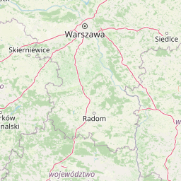
Map view of Doły Szczeckie Nature Reserve

Use this park location map to pinpoint Doły Szczeckie Nature Reserve in Poland, understand its exact geographic position, and read its mapped placement within the surrounding landscape more clearly.

Pigeon | © OpenStreetMap contributors

Location context for Doły Szczeckie Nature Reserve

Lublin Voivodeship
Park atlas

Compare surrounding upland reserves, forest communities, and karst terrain

Parks Near Rezerwat przyrody Doły Szczeckie, Exploring Regional Protected Landscapes

Browse other parks near Rezerwat przyrody Doły Szczeckie to examine similar upland forest ecosystems and karst topography across the surrounding region. Extending the geographic review helps trace connected protected landscapes and regional conservation patterns beyond a single reserve.
Nature reserveLubelskie Voivodeship
Mapped location lies within the park boundary#1 closest

Southeast

Szczecyn Nature Reserve: Mapping Protected Deciduous Forest Habitats in Eastern Poland

A vital mosaic of oak-hornbeam forest enclaves and nature reserves.

Szczecyn functions as a specialized Natura 2000 conservation landscape, spanning four forest enclaves across the border of the Lubelskie and Podkarpackie voivodeships. This site provides an essential reference for lowland deciduous forest protection, emphasizing the preservation of old-growth oak-hornbeam stands and thermophilic habitats. The area serves as a critical refuge for rare flora and invertebrates within a broader agricultural mosaic.

Area
9.325 km²
Established
2011
Relief
Upland
Climate
Temperate
Nature reserveLublin Voivodeship
About 5.4 km away#2 closest

Northeast

Rezerwat przyrody Marynopole: Mapping the Upland Forest Landscapes of Lublin Voivodeship

Protected silver fir and oak stands in the Wzniesienia Urzędowskie hills

Rezerwat przyrody Marynopole acts as a critical conservation site for silver fir and mature oak forest within the Lublin Voivodeship of southeastern Poland. This nature reserve offers deep insight into upland ecology, protecting old-growth stands that thrive across the rolling, loamy terrain of the Wzniesienia Urzędowskie mesoregion.

Area
1.57 km²
Established
1976
Relief
Upland
Scope
Terrestrial
Protected areaPoland
About 7.3 km away#3 closest

Southeast

Uroczyska Lasów Janowskich: Protected Forest and Wetland Geography in Eastern Poland

Mapping the extensive Natura 2000 lowland forest and peatland complexes

Spanning the Biłgoraj Plain and San River valley, Uroczyska Lasów Janowskich is a notable lowland forest complex in Poland. Its terrain integrates mature oak-hornbeam woods with diverse peatland systems, offering a clear look at how layered conservation strategies protect rare European habitats within a single continuous geographic block.

Area
345.443 km²
Established
2009
Relief
Lowland
Climate
Temperate
Protected landscapeTarnobrzeska Dolina Wisły
About 22 km away#4 closest

Southwest

Tarnobrzeska Dolina Wisły Protected Landscape: Mapped Riverine Geography and Habitat Corridor

A sprawling Vistula valley floodplain site in southeastern Poland.

The Tarnobrzeska Dolina Wisły protected area encompasses a 4,060-hectare corridor of rare lowland habitats. This map-focused site highlights an ecologically active river system composed of riparian forests, shifting banks, and extensive wetlands that define the regional geography of the middle Vistula basin.

Area
40.597 km²
Established
2011
Scope
Terrestrial
Water
Major water bodies
Protected landscapeLubelskie Voivodeship
About 29 km away#5 closest

North

Wrzelowiecki Park Krajobrazowy: Geographic Atlas and Protected Landscape Overview

Mapped upland terrain and Vistula valley geomorphology

Analyze the landform composition of Wrzelowiecki Park Krajobrazowy through its loess ravines, Cretaceous fossil exposures, and wetland river systems. This protected landscape preserves the regional integrity of the Wzniesienia Urzędowskie, offering a structured look at the interplay between highland forests and historic Polish river valley settlements.

Area
49.89 km²
Established
1990
Relief
Upland
Climate
Temperate
Nature reserveŚwiętokrzyskie Voivodeship
About 41 km away#6 closest

Northwest

Rezerwat przyrody Modrzewie: Protected Oak-Lime and Polish Larch Forest Reserve

Forest landscape discovery in the Świętokrzyskie region of Poland.

Located in the Kamienna Valley, Rezerwat przyrody Modrzewie acts as a vital protected area for mature, near-primary oak-lime forest. This nature reserve provides essential botanical context for the Polish larch, embedding a rich woodland fragment within the wider geographical tapestry of the Świętokrzyskie Voivodeship.

Area
0.047 km²
Established
1971
Relief
Lowland
Climate
Temperate
Nature reserveświętokrzyskie
About 43 km away#7 closest

Southwest

Ostoja Żyznów Protected Landscape: Loess Ravines and River Valleys of Świętokrzyskie

A dense mosaic of xerothermic grasslands and mixed forest ecosystems

Ostoja Żyznów protects a compact yet ecologically rich region characterized by deep loess gullies and the meandering paths of the Koprzywianka and Kacanka rivers. The area creates a striking transitional landscape, shifting from flat agricultural plateaus to steep, forest-covered ravines and cliff-like river walls. This site offers significant value for understanding regional biodiversity, featuring a rare combination of warm-dry grasslands and moisture-dependent peatland habitats in the heart of Poland.

Area
44.8 km²
Established
2011
Relief
Mixed relief
Climate
Temperate
Nature reserveLublin Voivodeship
About 46 km away#8 closest

Southeast

Kacze Błota Nature Reserve: Mapping the Protected Peatland Landscapes of Lublin Voivodeship

A study of high bogs and sandy dune forest terrain.

Kacze Błota is a protected nature reserve in Poland known for its sequence of transition mires and boggy coniferous woods. Positioned on the northern slopes of the Roztocze region, this site preserves unique plant species within its waterlogged depressions and acid-soil sandy ridges. The area remains a crucial example of historical landscape preservation in the Lublin Voivodeship, bridging the gap between upland forests and lowland river basins.

Area
1.679 km²
Established
1988
Relief
Lowland
Climate
Temperate

Common questions about visiting, size, designation, and location context for Doły Szczeckie Nature Reserve

Doły Szczeckie Nature Reserve FAQs for park facts, access, geography, and protected area context

Find quick answers about Doły Szczeckie Nature Reserve, including protected-area facts, park geography, trail and visitor context, and how the park fits into its surrounding country and regional landscape.
MoriAtlas Explorer

Continue Your Protected Areas Search Across the Global Atlas

Deepen your exploration by continuing the structured search for national parks and protected areas worldwide. Utilize the comprehensive filtering capabilities to compare different conservation landscapes and refine your understanding of global park geography. Discover more about the distribution and characteristics of protected natural areas.

Global natural geography