Mori Atlas logo
Nature reserveRezerwat przyrody Dolina Gwdy

A study of geomorphology and protected river corridors in the Pomeranian lake district

Rezerwat przyrody Dolina Gwdy: Mapping the Riverine Landscapes and Ancient Forested Terrain

Rezerwat przyrody Dolina Gwdy preserves a complex stretch of the Gwda River and its tributary the Czernica, characterized by a unique sequence of meanders, flood terraces, and deep ravines. Located within the Pomeranian Voivodeship, this nature reserve protects roughly 425 hectares of waterlogged alder swamp forests and veteran coniferous stands. The terrain reflects historical hydrological patterns, offering a clear view into the region's riverine geomorphology and ancient forest ecosystems.

river valleymeandersfloodplainwetland forestalder swampold-growth trees

Rezerwat przyrody Dolina Gwdy

Nature reserve

Park overview

Structured park overview, official facts, and landscape profile for Dolina Gwdy Nature Reserve

Dolina Gwdy Nature Reserve park facts, protected area profile, and essential visitor context

Review the core facts for Dolina Gwdy Nature Reserve, including designation, size, terrain, visitor scale, habitats, and operating context in one park-focused overview.

About Dolina Gwdy Nature Reserve

Dolina Gwdy Nature Reserve is a compact but ecologically rich protected area in the lake-district region of northern Poland. It lies in the gmina of Czarne, in Człuchowski County, part of the Pomeranian Voivodeship, and focuses on a defining segment of the Gwda River valley. The reserve is administered as a biocenotic and physiocenotic reserve, meaning it protects both living communities and physical features of the environment: the natural landforms of the valley, its hydrology, and the plant communities that have developed around them.

At the heart of the reserve is the meandering course of the Gwda and its tributary the Czernica. Over time these waters have shaped a system of river meanders, floodplain terraces, and erosional ravines, producing a varied topography in which wet hollows, drier terraces, and steep valley sides lie in close proximity. This mosaic of landforms supports a similarly varied mosaic of vegetation, ranging from waterlogged alder swamps on the lowest, wettest surfaces to coniferous forests on better-drained ground.

Beyond its natural features, the reserve preserves elements of regional forest-settlement landscape, including traditional buildings associated with the historical occupation of the valley by forest-based communities. It also contains the remains of an older infrastructure of small water-regulation and energy installations, now mostly ruined, that once influenced how water moved through the valley. The combination of river geomorphology, ancient forests, and these traces of human landscape use gives Dolina Gwdy a layered, integrated character rarely found in such a small reserve.

Quick facts and research context for Dolina Gwdy Nature Reserve

Dolina Gwdy Nature Reserve is a landscape-type (krajobrazowy) nature reserve in northern Poland, situated in the Pomeranian Voivodeship within Człuchowski County, in the gmina of Czarne. It was created by regulation of the Minister of Environmental Protection, Natural Resources, and Forestry on 21 December 1998, and is administered under the supervision of the Regional Director of Environmental Protection in Gdańsk, with the territory lying within the Czarne Człuchowskie Forest District (Nadleśnictwo Czarne Człuchowskie).

The reserve covers 424.60 hectares, slightly revised from the 428.20 hectares stated in its founding act. It protects landforms typical of the Gwda River valley and its Czernica tributary, including river meanders, flood terraces, ravines, alder swamp forests, and pine-dominated forests with old, large-diameter trees. The site borders the Wałeckie Lakeland and Gwda Valley Protected Landscape Area to the west.

Protection and recognition

Examine terrestrial protected area status and official recognition history.

Rezerwat przyrody Dolina Gwdy Protection Status and Designation Facts

Rezerwat przyrody Dolina Gwdy maintains a documented terrestrial protection status within its regional conservation landscape. Structured records outline the established management scope and verified designation data for this protected area.

Protection details

Protection scope
Terrestrial
Park context

Deeper park guide and search-rich context for Dolina Gwdy Nature Reserve

Dolina Gwdy Nature Reserve history, landscape, wildlife, and travel context

Explore Dolina Gwdy Nature Reserve through its history, landscape character, ecosystems, wildlife, conservation priorities, cultural context, and seasonal travel timing in a structured park guide built for atlas discovery and search intent.

Why Dolina Gwdy Nature Reserve stands out

The reserve is best known for its preserved river valley morphology: a sequence of meanders cut by the Gwda River and its tributary the Czernica, flanked by floodplain terraces and erosional ravines. It is also distinguished by its old-growth riparian forests, in particular alder swamp (ols) communities mixed with pine stands, where many trees have reached exceptional age and size for the region. Together, the hydrological landforms and the ancient, waterlogged woodland form the core identity of the protected area.

Dolina Gwdy Nature Reserve history and protected-area timeline

The Dolina Gwdy Nature Reserve was established in 1998, founded by a regulation of the Minister of Environmental Protection, Natural Resources, and Forestry dated 21 December 1998. The founding act set the reserve's area at 428.20 hectares, while the currently registered extent is 424.60 hectares, reflecting minor boundary adjustments made over time. The reserve was created as a landscape reserve (rezerwat krajobrazowy) of biocenotic and physiocenotic character, with the formal goal of preserving the landforms of the Gwda and Czernica valleys together with their associated natural plant communities.

Administrative responsibility for the reserve has rested with the Regional Director of Environmental Protection in Gdańsk, while the land itself falls under the management of the Czarne Człuchowskie Forest District. Although the reserve does not yet have a dedicated protection plan, its establishment placed the valley's meanders, terraces, ravines, and old-growth forests under legal protection and integrated it into the wider system of protected landscapes along the Gwda River corridor, where it now borders the Wałeckie Lakeland and Gwda Valley Protected Landscape Area.

Dolina Gwdy Nature Reserve landscape and geographic character

The landscape of Dolina Gwdy Nature Reserve is defined by the work of flowing water. The Gwda River and its tributary the Czernica have cut a series of pronounced meanders through this part of the Pomeranian lake district, leaving behind curved river bends, abandoned or partly abandoned channels, and gently sloping floodplain terraces on either side of the active stream. Where the rivers encounter more resistant material, the valley sides steepen into ravines and gullies, producing a varied terrain in a relatively compact area.

The combination of low-lying, periodically flooded meadows and terraces above the high-water line creates a clear vertical structure within the valley. Lower surfaces remain saturated or seasonally inundated, while higher terraces and slope edges are drier and support different vegetation. This landform diversity is one of the main features the reserve was created to protect, as it shapes both the soils and the plant communities of the area and gives the valley its distinctive, irregular shape.

Dolina Gwdy Nature Reserve ecosystems, habitats, and plant life

Ecologically, the reserve reflects the transitional character of the Gwda valley between open water, wetland, and forest. The lowest and wettest zones support alder swamp forest (ols), a community of black alder and related broadleaf species adapted to waterlogged, boggy soils. These swamp forests intergrade with pine-dominated stands on slightly better-drained ground, producing mixed woodland patterns in which coniferous and deciduous elements alternate depending on elevation and soil conditions.

A defining feature of the reserve's woodlands is the presence of notably old and large individual trees within both the alder swamp and the coniferous forest. The reserve's founding declaration explicitly highlights these veteran trees as part of the value being protected. The mix of semi-natural plant communities, boggy ground, and disturbance patterns from river dynamics supports a habitat mosaic that is characteristic of larger river valleys in the Pomeranian lake district, even though it is concentrated into a relatively small reserve.

Dolina Gwdy Nature Reserve wildlife and species highlights

The wildlife value of Dolina Gwdy is closely tied to its habitat mosaic of meandering river channels, swamp forests, coniferous stands, and floodplain terraces. Wet alder woodlands and boggy edges provide habitat typical of northern Polish river valleys, supporting communities of amphibians, wetland birds, and invertebrates associated with slow-moving, vegetated waters.

The presence of large old trees within both deciduous and coniferous stands increases habitat complexity, providing nesting sites, deadwood resources, and structural diversity that benefit a range of forest-dwelling species. While detailed species inventories are not documented in the source material, the reserve's combination of riverine waters, swamp forest, and old-growth trees makes it an ecologically meaningful refuge within the broader Gwda valley landscape.

Dolina Gwdy Nature Reserve conservation status and protection priorities

From a conservation standpoint, Dolina Gwdy Nature Reserve protects a representative example of the natural landforms and vegetation of the Gwda River valley, including meanders, flood terraces, ravines, and old-growth riparian forests. By safeguarding these features together rather than separately, the reserve maintains the ecological linkages between hydrology, soils, and plant communities that define the valley's character.

The reserve also has broader landscape-scale importance. It lies within the territory of the Czarne Człuchowskie Forest District and directly borders the Wałeckie Lakeland and Gwda Valley Protected Landscape Area, extending the effective protection of the Gwda River corridor east of that larger protected landscape zone. Although the reserve does not yet have an adopted protection plan, its formal designation ensures that its landforms and vegetation remain under legal protection under Polish nature conservation law.

Dolina Gwdy Nature Reserve cultural meaning and human context

The cultural dimension of Dolina Gwdy is tied to the historical forest-settlement character of the Gwda valley. Traditional rural buildings associated with forest-based communities are preserved within the reserve, reflecting a way of life once common in the wooded lowlands of northern Poland. These structures are part of the regional built heritage tied directly to the valley's landscape.

The reserve also preserves traces of an older, largely ruined infrastructure of water-regulation and small-scale energy installations that once shaped how water flowed through the valley. Although now largely derelict, these features are integrated into the reserve's protected scope as elements of regional landscape history linked to the river system.

Top sights and standout views in Dolina Gwdy Nature Reserve

Dolina Gwdy stands out for the close integration of river geomorphology and forest cover: meanders, terraces, and ravines are immediately accompanied by corresponding wetland and dry-ground forest communities. The presence of notably old and large trees in both alder swamp and coniferous stands gives the reserve a maturity often lacking in younger or disturbed forests in the region.

Its position adjoining the Wałeckie Lakeland and Gwda Valley Protected Landscape Area places it within a continuous corridor of protection along the Gwda River, reinforcing its role as a focal point of conservation in this part of the Pomeranian lake district.

Best time to visit Dolina Gwdy Nature Reserve

The reserve is most atmospheric in late spring and early summer, when rising river levels highlight the active meanders and floodplain terraces, and when wetland vegetation is at its most expressive. Late summer and early autumn bring drier conditions and good visibility into the forest interiors, while the structural character of the old trees stands out in the softer light of these seasons.

Winter, when snow cover reveals the meander patterns of the Gwda and Czernica and the contrast between open river channels and forested terraces, can also offer a memorable, quiet experience of the landscape, though visitors should be prepared for typical northern Polish winter conditions.
Monthly climate preview

Long-term representative temperature and precipitation metrics recorded at a fixed coordinate

Rezerwat przyrody Dolina Gwdy Climate Normals and Monthly Weather Patterns

Representative coordinates for Rezerwat przyrody Dolina Gwdy record recorded monthly variations in long-term temperature and precipitation normals from 1991 to 2020. Deeper monthly climate comparisons provide complete numerical distributions for every calendar cycle.
Annual mean8 °C
-3 °C19 °C
Jan-3°
Feb-1°
Mar
Apr
May13°
Jun16°
Jul19°
Aug19°
Sep14°
Oct
Nov
Dec-1°
Warmest month
July

18.8 °C

Coolest month
January

-2.6 °C

Wettest month
July

2.7 mm/day

Driest month
April

1.2 mm/day

Park location guide

Geography guide, regional context, and park location map for Dolina Gwdy Nature Reserve

Dolina Gwdy Nature Reserve park geography, regions, and map view in Poland

Understand where Dolina Gwdy Nature Reserve sits in Poland through a broader geographic reading of the surrounding landscape, nearby location context, and its mapped position within the national park landscape.

How Dolina Gwdy Nature Reserve fits into Poland

Poland, officially the Republic of Poland, is a Central European country spanning from the Baltic Sea in the north to the Carpathian Mountains in the south. It borders Germany, Czech Republic, Slovakia, Ukraine, Belarus, Lithuania, and Kaliningrad Oblast. The country has a temperate climate, diverse landscapes, and is known for its rich history, cultural heritage, and strong economic position within the EU.

Wider geography shaping Dolina Gwdy Nature Reserve in Poland

Poland occupies 312,696 km2 in Central Europe, extending from the Baltic Sea coast in the north to the Sudetes and Carpathian Mountains in the south. It borders Germany to the west, Czech Republic and Slovakia to the south, Ukraine and Belarus to the east, and Lithuania and Kaliningrad Oblast to the northeast. The landscape includes lowland plains, uplands, and mountain ranges.

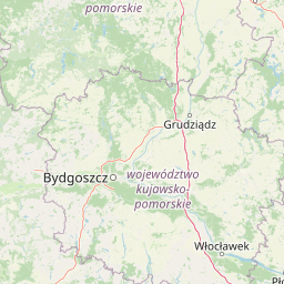
Map view of Dolina Gwdy Nature Reserve

Use this park location map to pinpoint Dolina Gwdy Nature Reserve in Poland, understand its exact geographic position, and read its mapped placement within the surrounding landscape more clearly.

Pigeon | © OpenStreetMap contributors

Location context for Dolina Gwdy Nature Reserve

Pomeranian Voivodeship
Park atlas

Compare nearby regional reserves and connected river valley ecosystems

Parks Near Rezerwat przyrody Dolina Gwdy and Surrounding Protected Landscapes

Browse protected areas near Rezerwat przyrody Dolina Gwdy to examine similar river valley corridors and wetland forest reserves. Comparing adjacent regional geography reveals broader conservation patterns across the Pomeranian lake district.
Nature reservePomeranian Voivodeship
About 20 km away#1 closest

East

Rezerwat przyrody Miłachowo: Protected Xerothermic Grassland and Nature Reserve Atlas

Mapping relict steppe communities in the Pomeranian Voivodeship

Located in the Krajeńskie Lakeland, Rezerwat przyrody Miłachowo preserves rare dry-grassland and shrub ecosystems. This nature reserve protects thermophilic vegetation on glacial valley slopes, providing vital ecological continuity for species adapted to sun-exposed, dry terrain far from their primary European strongholds.

Area
0.038 km²
Established
1976
Relief
Upland
Climate
Temperate
A soft watercolor painting showing a wide expanse of heathland with rolling green hills, patches of low-lying vegetation, and distant pale mountains.
Nature reserveWest Pomeranian Voivodeship
About 25 km away#2 closest

West

Diabelskie Pustacie Nature Reserve: Mapping the Largest Inland Heathland in Poland

Glacial sandr plains and protected lowland habitat geography.

Located in the West Pomeranian Voivodeship, Diabelskie Pustacie Nature Reserve is defined by its wide open sandr plains and complex glacial relief. This protected site integrates dry heathlands and moist depressions within a unique post-military landscape, offering deep insights into the region's natural terrain and conservation status.

Area
9.325 km²
Established
2008
Relief
Upland
Climate
Temperate
Nature reserveGreater Poland Voivodeship
About 28 km away#3 closest

Southeast

Uroczyska Kujańskie Nature Reserve: A Geographic Overview of the Krajeńskie Lakeland

Mapped protected landscapes, glacial lakes, and old-growth oak forests.

Uroczyska Kujańskie provides a rare study in post-glacial landscape architecture. Situated in the Greater Poland Voivodeship, this site links dystrophic lakes, travertine-forming spring fens, and extensive acid oak forests. Use our atlas data to understand the complex ecological boundaries and hydrological features that define this protected Natura 2000 habitat.

Area
10.182 km²
Relief
Lowland
Scope
Terrestrial
Water
Major water bodies
A watercolor painting of a serene landscape with soft green hills and distant mountains.
Nature reserveGreater Poland Voivodeship
About 32 km away#4 closest

Southwest

Rezerwat przyrody Diabli Skok: Protected Forest and Glacial Ravine Geography

A sheltered microclimate and moraine reserve in Greater Poland.

Rezerwat przyrody Diabli Skok protects a sharp, deeply incised gorge that contrasts with the surrounding flat glacial plains. This site is defined by its old-growth beech woodland and numerous groundwater springs, providing a critical habitat for diverse plant species and montane moss communities within the regional geography of the Greater Poland Voivodeship.

Area
0.21 km²
Established
1961
Relief
Upland
Climate
Temperate
Nature reserveKuyavian-Pomeranian Voivodeship
About 33 km away#5 closest

Southeast

Rezerwat przyrody Dęby Krajeńskie: Mapping Forest Biodiversity and Protected Land

Nature reserve geography in Kuyavian-Pomeranian Voivodeship

Dęby Krajeńskie stands as a significant lowland woodland reserve featuring old-growth oak and beech stands. Located within the Krajeński Landscape Park, it represents a core protected area for regional avian populations and spring-flowering forest herbs. Explore the terrain characteristics and ecological significance of this preserved Polish woodland environment.

Area
0.458 km²
Established
2001
Relief
Lowland
Scope
Terrestrial
Nature reserveZachodniopomorskie
About 36 km away#6 closest

Southwest

Rezerwat przyrody Dolina Rurzycy: Mapped Geography and Protected Area Data

A glacial river valley reserve in the West Pomeranian landscape

Trace the ecological profile of Rezerwat przyrody Dolina Rurzycy. This entry provides map-based context for its deeply incised river valley, interconnected glacial lake chain, and rare calcareous spring communities within the Wałcz Forests region.

Area
5.547 km²
Established
2005
Relief
Upland
Climate
Temperate
Protected landscapePomeranian Voivodeship
About 38 km away#7 closest

Northeast

Zaborski Park Krajobrazowy: Geographic Profile of a Polish Protected Landscape Area

Tuchola Forest region, Pomeranian Voivodeship

Investigate the unique terrain of Zaborski Park Krajobrazowy, a protected landscape defined by its dense network of glacial lakes and sandy outwash plains. This territory provides a comprehensive view of northern Polish lowland geography, highlighting the ecological significance of its river valleys and relic forest habitats within the broader Tuchola Forest ecosystem.

Area
340.3 km²
Established
1990
Relief
Lowland
Climate
Temperate
Nature reservePomeranian Voivodeship
About 39 km away#8 closest

Northeast

Jezioro Sporackie Nature Reserve: Mapped Geography and Protected Area Context

Exploring the lobelia lake and peatland mosaic in Pomeranian Voivodeship

Jezioro Sporackie Nature Reserve protects a vital ecological gradient ranging from nutrient-poor aquatic habitats to wooded terrestrial margins. The site preserves Sporacz, a glacial lake recognized for its specialized flora, alongside the surrounding transitional mire and forest compartments that form its primary buffer zone in Northern Poland.

Area
0.176 km²
Established
1965
Relief
Lowland
Climate
Temperate

Common questions about visiting, size, designation, and location context for Dolina Gwdy Nature Reserve

Dolina Gwdy Nature Reserve FAQs for park facts, access, geography, and protected area context

Find quick answers about Dolina Gwdy Nature Reserve, including protected-area facts, park geography, trail and visitor context, and how the park fits into its surrounding country and regional landscape.
MoriAtlas Explorer

Continue Your Protected Areas Search Across the Global Atlas

Deepen your exploration by continuing the structured search for national parks and protected areas worldwide. Utilize the comprehensive filtering capabilities to compare different conservation landscapes and refine your understanding of global park geography. Discover more about the distribution and characteristics of protected natural areas.

Global natural geography