
Mori Atlas logo
Nature reserveRezerwat przyrody Dolina Mnikowska

A detailed geographic study of protected karst terrain and diverse woodland ecosystems

Rezerwat przyrody Dolina Mnikowska: Mapped Limestone Gorge and Protected Forest Landscapes

Rezerwat przyrody Dolina Mnikowska stands as a protected limestone landscape deeply incised into the Garb Tenczyński upland of southern Poland. This nature reserve maps a compact mosaic of oak-hornbeam forests, xerothermic rock-sward communities, and towering cliff formations carved by the Sanka River. Explore the intricate topography of this karst environment, where rock gates, pinnacles, and historic caves define a distinct regional geography near Kraków.

limestone gorgekarst landscaperock formationsriver gorgePolish Juraoak-hornbeam forest
A graphic illustration showing a narrow wooden footbridge crossing a shallow river inside a limestone gorge, surrounded by tall slender trees.

Rezerwat przyrody Dolina Mnikowska

Nature reserve

Park overview

Structured park overview, official facts, and landscape profile for Dolina Mnikowska Nature Reserve

Dolina Mnikowska Nature Reserve park facts, protected area profile, and essential visitor context

Review the core facts for Dolina Mnikowska Nature Reserve, including designation, size, terrain, visitor scale, habitats, and operating context in one park-focused overview.

About Dolina Mnikowska Nature Reserve

Dolina Mnikowska Nature Reserve protects one of the more scenically concentrated stretches of the Tenczyński upland, a wooded limestone ridge northwest of Kraków in southern Poland. Although small in extent, it captures an unusually varied cross-section of the ecosystems that characterize this part of the Polish Jura, from forested ravine slopes to warm, sun-baked rock swards, all within a single short valley.

The core of the reserve is a gorge of the Sanka River. Over the course of geologic time, the stream has cut down through Jurassic limestone to create cliffs that in places reach around 80 meters in height. On these cliffs, weathering and erosion have produced a gallery of distinctive rock forms: freestanding pillars and pinnacles, rock towers, natural arches, and grouped needles that give the valley its picturesque character. Mid-valley, where a broader amphitheater-like niche known as the Cyrk opens up, several rock shelters and small caves are found, including the well-known Jaskinia za Matką Boską.

Ecologically, the reserve stands out for the heterogeneity of its vegetation. Calcareous outcrops and the deeper, shaded ravine create very different microclimates across short distances. Oak-hornbeam forest dominates on better-developed soils, mixed boreal-style coniferous stands occupy drier slopes, and narrow strips of riparian forest line the Sanka itself. On the warmer, south-facing rocks, xerothermic sward communities host warmth-loving plants that would not normally occur alongside species such as common mayflower (Convallaria majalis) and martagon lily found in the more mesic woodland. The valley is also notable for several hundred-year-old ivy plants growing on rock faces.

The reserve sits within the larger Tenczyński Park Krajobrazowy and partially overlaps the Natura 2000 habitat site Dolina Sanki (PLH120059), extending its conservation significance beyond Poland's national reserve system. Despite this layered protection, as of early 2021 the reserve still lacked a formal management plan, leaving its day-to-day conservation status shaped mostly by regional landscape park oversight. Together, its geological drama, ecological diversity, and proximity to Kraków make Dolina Mnikowska a significant small reserve for researchers, conservation planners, and visitors interested in the natural heritage of the Polish Jura.

Quick facts and research context for Dolina Mnikowska Nature Reserve

Dolina Mnikowska Nature Reserve lies in the gmina of Liszki in Kraków County, Lesser Poland Voivodeship, fully within the broader Tenczyński Park Krajobrazowy and partially overlapping the Natura 2000 habitat site Dolina Sanki (PLH120059). The reserve was established in early 1963 following an order by the Minister of Forestry and the Wood Industry.

It covers roughly 21 hectares of forested valley and cliffs along the Sanka River and is part of the Garb Tenczyński mesoregion of the Polish Jura. Approximately 85% of its area is wooded, combining deciduous, mixed, and riparian forest types with rocky grassland communities that together form one of the most habitat-diverse small reserves in the Kraków area.

Protection and recognition

Examine documented terrestrial protection metrics and official conservation status details.

Rezerwat przyrody Dolina Mnikowska Protection Status and Designated Area Record

Rezerwat przyrody Dolina Mnikowska maintains a documented terrestrial protection scope within its regional landscape. Structured records outline the official conservation status and administrative designation history associated with this protected natural area.

Protection details

Protection scope
Terrestrial
Transboundary protection
No
Park context

Deeper park guide and search-rich context for Dolina Mnikowska Nature Reserve

Dolina Mnikowska Nature Reserve history, landscape, wildlife, and travel context

Explore Dolina Mnikowska Nature Reserve through its history, landscape character, ecosystems, wildlife, conservation priorities, cultural context, and seasonal travel timing in a structured park guide built for atlas discovery and search intent.

Why Dolina Mnikowska Nature Reserve stands out

Dolina Mnikowska is best known for its deeply carved limestone gorge on the Sanka River, where sheer rock faces rise up to 80 meters above the streambed. The cliffs and exposed rock formations create a striking limestone landscape within an otherwise gentle part of the Polish Jura. The reserve is also recognized for its rich mosaic of habitats compressed into a small area, where oak-hornbeam forests, mixed coniferous stands, and riparian woodland meet xerothermic sward vegetation on sunny rocks. Among the named attractions are the rock amphitheater known as the Cyrk and the pilgrimage cave Jaskinia za Matką Boską.
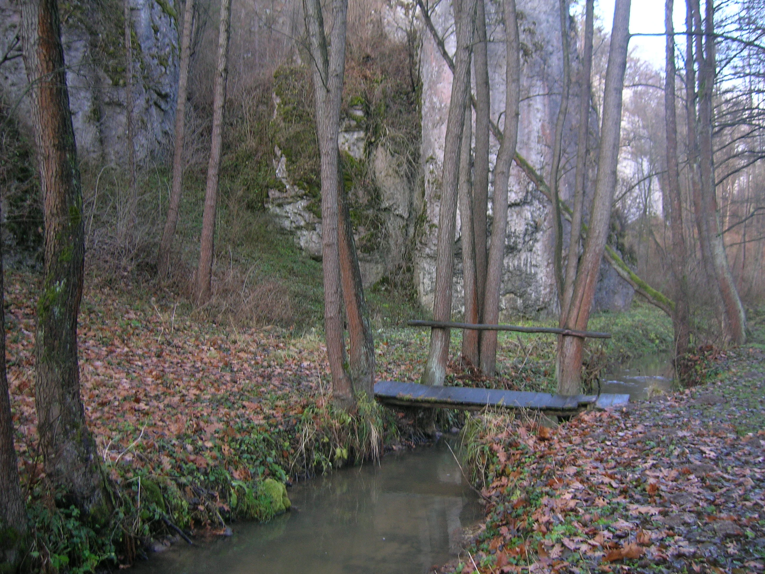
A small, narrow stream flows through a woodland setting with limestone rock faces visible in the background and a simple wooden footbridge crossing the water.
The Sanka stream flowing through the forested landscape of Dolina Mnikowska nature reserve.

Dolina Mnikowska Nature Reserve history and protected-area timeline

Dolina Mnikowska was designated as a landscape nature reserve on 16 February 1963 under Order No. 7 of the Minister of Forestry and the Wood Industry, dated 14 January 1963. The legal basis was published in the Polish Monitor (Monitor Polski) of 1963, No. 13, item 76, a standard form of regulatory announcement used by the Polish government at the time.

The establishment order defined the purpose of protection as preserving the picturesque rocky gorge, along with its geological curiosities and its living natural assets, for scientific, educational, and tourist reasons. That triple mandate reflects mid-twentieth-century conservation thinking in Poland, when many small reserves were created around distinctive landscape features with both research and recreational value in mind.

The reserve was later incorporated into the wider Tenczyński Park Krajobrazowy, and its valley partially coincides with the EU-level Natura 2000 habitat site Dolina Sanki, formally designated as PLH120059. As of January 2021, the reserve had not yet been covered by a dedicated protection plan or set of conservation tasks, a common situation for older Polish reserves whose original designation predated modern planning frameworks.

Dolina Mnikowska Nature Reserve landscape and geographic character

The landscape of Dolina Mnikowska is defined by a narrow limestone gorge roughly cut into the Garb Tenczyński, one of the wider upland ridges that mark the northern edge of the Kraków-Częstochowa Upland. The Sanka River, an eventual tributary of the Vistula, has incised the Jurassic limestone bedrock to form a valley whose cliffs reach about 80 meters in depth.

Within this gorge, erosion has shaped a remarkable variety of rock forms. Towers, grouped needles, isolated pinnacles, and rock gates line the valley walls, and the middle section broadens into an amphitheater-like niche known locally as the Cyrk, where the cliff face curves inward and shelters several rock caves and shelters. The most widely recognized of these is Jaskinia za Matką Boską, a chamber that has long attracted visitors and pilgrims.

Outside the deepest part of the cut, the topography transitions into gentler forested slopes typical of the Tenczyński upland. This contrast between enclosed rocky gorge and surrounding woodland terrain gives the reserve its characteristic visual rhythm of tightly framed cliff views opening into broader leafy vistas. A blue tourist trail follows the valley floor from Mników toward Zabierzów, allowing the landscape transitions to be observed on foot.

Dolina Mnikowska Nature Reserve ecosystems, habitats, and plant life

Ecologically, Dolina Mnikowska is essentially a forest reserve threaded through a limestone canyon. Approximately 85% of its area is wooded, with the remainder made up of exposed rock, narrow cliff ledges, and small patches of scrub.

The dominant forest communities reflect the variability of soil and slope conditions across the gorge. Oak-hornbeam forest, a classic Central European woodland type, occupies mesic sites on deeper soils. Mixed coniferous stands of pine and spruce, often with birch, cover the drier, sandier slopes. Along the banks of the Sanka itself, a ribbon of riparian forest persists, tolerant of periodic flooding and high groundwater. Together these woodlands create a multilayered canopy and understory that supports a diverse community of woodland plants.

The exposed rock faces and sunny ledges introduce a markedly different flora. Xerothermic swards and rock-ledge vegetation thrive on the warm, dry, calcareous substrate, hosting species that would normally be found much farther south or east. These open communities sit in striking contrast to the shaded forest interior just meters away, producing one of the reserve's signature features: the ability to move from thermophilic grassland to mesic woodland within a few steps. Centuries-old ivy plants further illustrate the longevity and ecological continuity of the rocky habitats.

Dolina Mnikowska Nature Reserve wildlife and species highlights

Wildlife information specific to Dolina Mnikowska is relatively limited in available sources, and most observation of fauna occurs in the broader context of the Tenczyński Park Krajobrazowy and the Natura 2000 habitat site Dolina Sanki. The reserve's mosaic of habitats, including cliffs, caves, deciduous forest, coniferous forest, riparian woodland, and rock swards, suggests niches for a typical range of upland and valley wildlife for this region of the Polish Jura.

Rock shelters and caves provide roosting and sheltering sites that are often significant for bats and cave-dwelling invertebrates, while the mix of mature broadleaf and coniferous stands offers habitat for woodland birds typical of Central European upland forests. The Sanka corridor itself functions as a small-scale wildlife corridor through agricultural surroundings northwest of Kraków. Without species-specific records in the source material, more detailed wildlife content cannot be reliably supplied.

Dolina Mnikowska Nature Reserve conservation status and protection priorities

Dolina Mnikowska is significant for conservation because it anchors, in a small area, a combination of habitats that are individually uncommon in this part of the Polish Jura. The co-occurrence of calcareous cliffs, oak-hornbeam forest, mixed coniferous forest, and xerothermic rock swards within a single short valley makes the reserve a reference site for studying how these habitats interact on calcareous substrates.

The reserve sits fully inside the Tenczyński Park Krajobrazowy, a regional landscape park that provides a broader layer of landscape-scale protection. Beyond national-level protection, part of the reserve overlaps the Natura 2000 habitat site Dolina Sanki (PLH120059), giving it European-level recognition for its habitat value.

The original establishment order cited the protection of a picturesque rocky gorge together with its scientific, educational, and touristic values, an unusually broad framing that underscores the reserve's role as a natural-monument landscape as much as an ecological site. As of January 2021, however, the reserve still lacked a formal protection plan and defined conservation tasks, a gap that can complicate active management despite the multiple legal layers under which the valley is shielded.

Dolina Mnikowska Nature Reserve cultural meaning and human context

The valley carries cultural weight beyond its natural features. A tradition of pilgrimage is anchored at the chapel and rock cave known as Matka Boża Skalska, located in the gorge. A set of Stations of the Cross (Droga Krzyżowa) was installed along the path between the village of Mników and the cave, beginning near the church of Saint Brother Albert in Mników, transforming the natural valley into a spiritual landscape as well as a natural one.

Locally, the villages of Mników and Czułów border the reserve, and the valley has long functioned as a place for both quiet nature observation and modest local recreation, linked historically to its proximity to Kraków. The combination of religious heritage, scenic beauty, and convenient access has shaped how residents and visitors relate to the gorge over the twentieth and twenty-first centuries.

Top sights and standout views in Dolina Mnikowska Nature Reserve

Dolina Mnikowska's strongest features center on the dramatic limestone gorge itself: sheer cliffs, isolated rock towers, grouped pinnacles, and rock gates squeezed between wooded slopes. The central amphitheater, known as the Cyrk, and the pilgrimage cave Jaskinia za Matką Boską give the reserve focal points that are easily understood by visitors.

Ecological richness out of proportion to its size is a second highlight: oak-hornbeam stands, coniferous slopes, riparian woodland, and xerothermic swards meet within a single short valley that also hosts centuries-old ivy and regionally rare plants such as martagon lily and Daphne mezereum (wawrzynek wilczełyko). The valley is also one of the more accessible natural sites northwest of Kraków, reached via a marked blue trail that links the villages of Mników and Zabierzów.

Best time to visit Dolina Mnikowska Nature Reserve

Dolina Mnikowska reads differently across the seasons. Spring is often the most rewarding period for plant interest, as woodland wildflowers such as mayflower and martagon lily emerge and the fresh green of the foliage intensifies the visibility of limestone outcrops and cliff formations along the gorge.

Summer brings full leaf cover that accentuates the depth of the valley and adds cool shade at the bottom, though dense foliage can partly obscure rock features from the trail. Autumn, with its lower sun and colored canopy, casts long shadows into the gorge, often producing the most atmospheric experience for those interested in the scenic landscape itself. In winter, when leaves are gone, the architecture of the cliffs, towers, and rock gates becomes most visible, and snow can highlight the karst sculpting of the valley walls.


Monthly climate preview

Long-term temperature ranges and monthly precipitation recorded at the representative coordinate

Rezerwat przyrody Dolina Mnikowska Climate Normals and Annual Weather Patterns

Historical data records monthly temperature variations and precipitation totals measured across the representative coordinate at Rezerwat przyrody Dolina Mnikowska. Detailed twelve-month climate normals provide complete metrics for evaluating long-term environmental patterns.
Annual mean8 °C
-3 °C20 °C
Jan-3°
Feb-2°
Mar
Apr
May14°
Jun17°
Jul20°
Aug19°
Sep14°
Oct
Nov
Dec-2°
Warmest month
July

19.6 °C

Coolest month
January

-3.2 °C

Wettest month
July

3.5 mm/day

Driest month
December

1.3 mm/day

Park location guide

Geography guide, regional context, and park location map for Dolina Mnikowska Nature Reserve

Dolina Mnikowska Nature Reserve park geography, regions, and map view in Poland

Understand where Dolina Mnikowska Nature Reserve sits in Poland through a broader geographic reading of the surrounding landscape, nearby location context, and its mapped position within the national park landscape.

How Dolina Mnikowska Nature Reserve fits into Poland

Poland, officially the Republic of Poland, is a Central European country spanning from the Baltic Sea in the north to the Carpathian Mountains in the south. It borders Germany, Czech Republic, Slovakia, Ukraine, Belarus, Lithuania, and Kaliningrad Oblast. The country has a temperate climate, diverse landscapes, and is known for its rich history, cultural heritage, and strong economic position within the EU.

Wider geography shaping Dolina Mnikowska Nature Reserve in Poland

Poland occupies 312,696 km2 in Central Europe, extending from the Baltic Sea coast in the north to the Sudetes and Carpathian Mountains in the south. It borders Germany to the west, Czech Republic and Slovakia to the south, Ukraine and Belarus to the east, and Lithuania and Kaliningrad Oblast to the northeast. The landscape includes lowland plains, uplands, and mountain ranges.

Map view of Dolina Mnikowska Nature Reserve

Use this park location map to pinpoint Dolina Mnikowska Nature Reserve in Poland, understand its exact geographic position, and read its mapped placement within the surrounding landscape more clearly.

Pigeon | © OpenStreetMap contributors

Location context for Dolina Mnikowska Nature Reserve

Lesser Poland Voivodeship

Visual research guide to the terrain, limestone cliffs, and diverse forest habitats of the reserve.

Rezerwat przyrody Dolina Mnikowska Photos: Limestone Gorge Scenery and Protected Landscapes

Photographic records reveal the dramatic limestone gorge, sheer rock towers, and forested slopes that define the protected terrain of Rezerwat przyrody Dolina Mnikowska. Visual exploration highlights the complex mosaic of oak-hornbeam woods and rare plant habitats across the surrounding upland landscape.

A small, narrow stream flows through a woodland setting with limestone rock faces visible in the background and a simple wooden footbridge crossing the water.

Park atlas

Compare nearby limestone gorges and regional nature reserves across southern Poland.

Parks Near Rezerwat przyrody Dolina Mnikowska and Surrounding Protected Landscapes

Browse protected areas and connected forest reserves located close to Rezerwat przyrody Dolina Mnikowska. Regional park comparisons reveal shared limestone topography and upland habitat patterns across the surrounding territory.
Protected areaLesser Poland Voivodeship
About 4.3 km away#1 closest

Southwest

Rudniańskie Modraszki, Kajasówka: Protected Area Geography and Habitat Mapping

Lesser Poland Voivodeship, Southern Poland

Rudniańskie Modraszki, Kajasówka represents a core conservation zone defined by its rare xerothermic and molinia meadow habitats. Spanning the transition between ridge and depression landscapes, this area provides a structured look at how small-scale habitat protection supports essential butterfly populations within the diverse geography of southern Poland.

Area
4.25 km²
Established
2011
Relief
Upland
Scope
Terrestrial
Protected landscapeLesser Poland Voivodeship
About 5.9 km away#2 closest

Northwest

Tenczyński Park Krajobrazowy: Protected Landscape and Karst Geography in Lesser Poland

Mapped limestone ridges and forest corridors near Kraków

Discover Tenczyński Park Krajobrazowy, a protected landscape park located in Lesser Poland Voivodeship. This geographic study covers the Garb Tenczyński ridge, where karst limestone formations, small caves, and volcanic outcrops shape a diverse terrain spanning from marshy lowlands to upland forest ridges.

Area
136.581 km²
Established
1981
Relief
Upland
Climate
Temperate
A soft watercolor painting of a winding stream flowing through a green valley with light trees, under a pale pink and yellow sky.
Nature reservePoland
About 7.4 km away#3 closest

West

Rezerwat przyrody Dolina Potoku Rudno: Nature Reserve and Protected Landscape Atlas

Geographic map and protected forest terrain in Lesser Poland

Situated in the Rudno Stream valley, this nature reserve offers a detailed look at preserved alder floodplain ecosystems and rocky gorge formations. The area provides a critical protected woodland link within the Kraków-Częstochowa Upland. Use the atlas data to examine the reserve boundaries, geological exposures, and regional landscape connections in Poland.

Area
0.959 km²
Established
2001
Relief
Upland
Climate
Temperate
A pale, minimalist watercolor illustration depicting a soft, winding river valley surrounded by distant hills and coniferous forests.
Protected landscapeLesser Poland Voivodeship
About 10 km away#4 closest

East

Bielańsko-Tyniecki Park Krajobrazowy Protected Landscape and Regional Geography

Limestone terrain and Vistula valley river corridors in Lesser Poland

Bielańsko-Tyniecki Park Krajobrazowy anchors a complex protected landscape near Kraków, featuring dramatic limestone rock groups, ancient forest complexes, and extensive river meadows. This detailed overview maps its karst caves, Natura 2000 sites, and cultural heritage, documenting the rare overlap of upland ridges and alluvial floodplains within the Lesser Poland Voivodeship.

Area
63.591 km²
Established
1981
Relief
Upland
Climate
Temperate
A horizontal watercolor painting of a green meadow, wetland area, and a soft forest line against distant hills.
Nature reserveLesser Poland Voivodeship
About 12 km away#5 closest

Southeast

Skawiński obszar łąkowy Nature Reserve: Geography and Protected Landscape Atlas

Lesser Poland regional meadow habitat mapping.

The Skawiński obszar łąkowy nature reserve protects a mosaic of wet, variable-moisture meadows that support rare butterfly populations. Situated on the southern fringe of the Kraków region, this site represents a crucial example of traditional lowland grassland conservation within a busy urban corridor. Access geographic context and boundary information for this essential Lesser Poland protected area.

Area
0.441 km²
Established
2011
Relief
Lowland
Scope
Terrestrial
Watercolor painting of a valley landscape with rolling hills, limestone rock formations on the right, and soft green vegetation.
Nature reserveLesser Poland Voivodeship
About 12 km away#6 closest

North

Rezerwat przyrody Dolina Racławki: Protected Limestone Valley and Karst Geography

Explore the forest mosaic and geological cliff features in Lesser Poland

The Rezerwat przyrody Dolina Racławki landscape reserve is a significant protected area in the Olkuska Upland. Spanning a long limestone valley, the reserve features a network of caves, rock shelters, and steep cliffs built from Carboniferous and Jurassic bedrock. Its combination of layered forest communities and protected orchid populations marks it as a vital site for understanding the natural heritage and regional geography of southern Poland.

Area
4.739 km²
Established
1962
Relief
Upland
Climate
Temperate
Watercolor painting of a pastoral landscape featuring soft, rolling hills, a line of trees, and muted earth tones, presented as a wide, horizontal strip.
Nature reserveLesser Poland Voivodeship
About 13 km away#7 closest

Northwest

Dolina Eliaszówki Nature Reserve: Protected Karst Valley and Forest Geography in Lesser Poland

A study of limestone outcrops and mature forest habitats in southern Poland

Dolina Eliaszówki Nature Reserve encompasses a deeply incised limestone valley characterized by diverse forest communities and complex karst geomorphology. The reserve protects an integrated network of rock outcrops, caves, and springs, framing historical monastic landmarks within a continuous protected forest corridor. It offers an essential view into the layered natural and cultural history of the Kraków-Częstochowa Upland.

Area
1.096 km²
Established
1989
Relief
Upland
Climate
Temperate
A flat-style vector illustration showing a winding river flowing through a lush green valley towards a large mountain with a waterfall, surrounded by trees and stylized clouds.
Nature reserveLesser Poland Voivodeship
About 13 km away#8 closest

Northeast

Rezerwat przyrody Dolina Kluczwody: Karst Valley and Protected Nature Reserve Geography

Exploring the limestone cliffs of Lesser Poland Voivodeship

Dolina Kluczwody represents a quintessential limestone valley landscape in southern Poland, featuring a blend of forest cover and exposed rock swards. As a protected nature reserve, it forms a crucial habitat within the Dolinki Krakowskie complex, preserving unique karst terrain and stream-fed ecosystems for scientific and environmental monitoring.

Area
0.352 km²
Established
1989
Relief
Upland
Climate
Temperate

Common questions about visiting, size, designation, and location context for Dolina Mnikowska Nature Reserve

Dolina Mnikowska Nature Reserve FAQs for park facts, access, geography, and protected area context

Find quick answers about Dolina Mnikowska Nature Reserve, including protected-area facts, park geography, trail and visitor context, and how the park fits into its surrounding country and regional landscape.
MoriAtlas Explorer

Continue Your Protected Areas Search Across the Global Atlas

Deepen your exploration by continuing the structured search for national parks and protected areas worldwide. Utilize the comprehensive filtering capabilities to compare different conservation landscapes and refine your understanding of global park geography. Discover more about the distribution and characteristics of protected natural areas.

Global natural geography